It looks like you're using an Ad Blocker.
Please white-list or disable AboveTopSecret.com in your ad-blocking tool.
Thank you.
Some features of ATS will be disabled while you continue to use an ad-blocker.

Quake Watch 2013
page: 81share:
See what I said? and now 3 5ers today...
and this has nothing to do with prediction. this is just a normal cycle. I hope some people on this forum will learn this one day.
Even though that are the ones that are not in the quake watch threads.
and this has nothing to do with prediction. this is just a normal cycle. I hope some people on this forum will learn this one day.
Even though that are the ones that are not in the quake watch threads.
Tomorrow this quake will drop off the 7 days listings. GFZ and EMSC both have, and have always had, it at 6.1 but USGS had maintained 5.9 despite that
fact that their wphase moment tensor shows 6.0. Their body MT
used to but has been changed.
Will it get changed and how long?
Prov,Date/Time UTC,Latitude,Longitude,Magnitude,Depth(Km),Location
emsc,2013-04-22 01:16:38, 18.239, -102.043, 6.1, 70.0, Michoacan Mexico
usgs,2013-04-22 01:16:33, 18.158, -102.080, 5.9, 28.5, 21Km Ne Of Las Guacamayas. Mexico (5) [F]
gfzp,2013-04-22 01:16:33, 18.150, -102.070, 6.1, 29.0, Michoacan. Mexico
Will it get changed and how long?
reply to post by PuterMan
Was located at the south pacific ocean were this mag 5 is at
Type: Earthquake
Magnitude: 5
DateTime: Monday April 29 2013, 10:30:45 UTC
Region: east central Pacific Ocean
Depth: 10 km
Source: USGS Feed
Location
5.482°N, 99.153°W
On a side note. The Los Angeles Quake Cam is really active today
volcanic activity ???
abclocal.go.com...
Was located at the south pacific ocean were this mag 5 is at
Type: Earthquake
Magnitude: 5
DateTime: Monday April 29 2013, 10:30:45 UTC
Region: east central Pacific Ocean
Depth: 10 km
Source: USGS Feed
Location
5.482°N, 99.153°W
edit on 7/30/2012 by dreamfox1 because:
On a side note. The Los Angeles Quake Cam is really active today
volcanic activity ???
abclocal.go.com...
edit on 7/30/2012 by dreamfox1 because: (no reason given)
edit on 7/30/2012 by
dreamfox1 because: ?
Biggish one in the Azores near the triple junction
geofon.gfz-potsdam.de...
More in a mo
EMSC
geofon.gfz-potsdam.de...
More in a mo
Magnitude M 5.9
Region AZORES ISLANDS, PORTUGAL
Date time 2013-04-30 06:25:23.0 UTC
Location 37.51 N ; 25.02 W
Depth 10 km
Distances 1397 km W of Lisbon, Portugal / pop: 517,802 / local time: 07:25:23.0 2013-04-30
62 km SE of Ponta Delgada / pop: 20,056 / local time: 06:25:00.0 2013-04-30
39 km SE of Furnas, Portugal / pop: 1,599 / local time: 06:25:23.0 2013-04-30
EMSC
edit on 30/4/2013 by PuterMan because: (no reason given)
reply to post by PuterMan
wow what going on that side ????
Magnitude: 6
DateTime: Tuesday April 30 2013, 06:25:23 UTC
Region: Azores Islands, Portugal.
Depth: 15 km
Source: GeoScience Australia
and then
Magnitude: 5.8
DateTime: Tuesday April 30 2013, 06:25:22 UTC
Region: Azores Islands Region
Depth: 2 km
Source: CSEM-EMSC Feed
and also
Magnitude: 5.6
DateTime: Tuesday April 30 2013, 06:56:49 UTC
Region: Antigua and Barbuda region, Leeward Islands
Depth: 38 km
Source: USGS Feed
edit on 7/30/2012 by dreamfox1 because: ???
@ dreamfox1
Ionospheric map for 6:00UTC
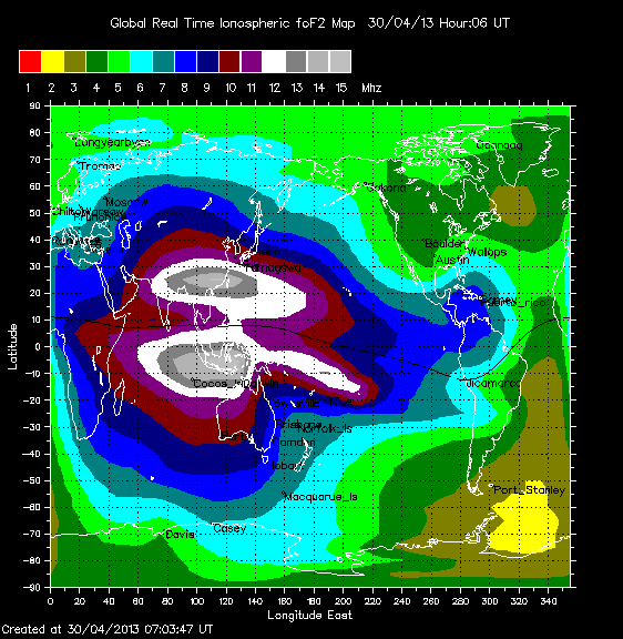
what say ye?
That theory has been dis-credited, again.
Where's the Java quake?
oh its over in the Azores
Ionospheric map for 6:00UTC
what say ye?
That theory has been dis-credited, again.
Where's the Java quake?
oh its over in the Azores
reply to post by dreamfox1
This seismogram is from a station on the island where the quake was just 16km off the coast.
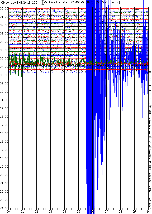
What is going on? Who knows? Biggie on the way? Maybe!
This seismogram is from a station on the island where the quake was just 16km off the coast.
What is going on? Who knows? Biggie on the way? Maybe!
This 5.7 off the coast of Japan is getting awfully close to the triple junction!
earthquake.usgs.gov...
earthquake.usgs.gov...
April 2013 interactive maps, 17,212 events
[color=8BB381 ]click on the name to go to the relevant map
New Zealand total= 1,362, TTNT= 6,164
Chile total= 312, TTNT= 8,760
Japan total= 7,579, TTNT= 1,093,510
Italy total 1,256, TTNT= 43
Greece total =1,752, TTNT= 1,408
Turkey total= 2,414, TTNT= 2,171
China total= 1,935, TTNT= 681,238
Thailand/Burma total= 49, TTNT= 6,411
Iran total= 262, TTNT= 5,396,325
Puerto Rico total= 119, TTNT= 57
Spain/Canaries/Azores total= 676, TTNT=1,554
Egypt total= 89, TTNT= 18
Iceland total= 1159, TTNT= 1,098
there are some duplications, such as some Greece/Turkey and China/Japan/Burma
Japan is not quite there, 9 hours short of the end of the month, due to JMA review proceedure taking 3 days.
Sources:
GNS GeoNet Rapid earthquake catalogue
Servicio Sismológico Universidad de Chile
JMA unified hypocenter catalog
ISIDe-Istituto Nazionale di Geofisica e Vulcanologia (INGV)
Institute of Geodynamics, National Observatory of Athens, Greece
DDA Catalog, Turkish Republic Disaster and Emergency Management Presedency
China Earthquake Networks Center
Seismological Bureau , Thai Meteorological Department
International Institute of Earthquake Engineering and Seismology, Iran
Puerto Rico Seismic Network
Instituto Geográfico Nacional
National Research Institute of Astronomy and Geophisics
Icelandic Meteorological Office
Iceland was the hardest, they way they present their dates is a nightmare for Excel to format, and I gave up trying to get the location names.
[color=8BB381 ]click on the name to go to the relevant map
New Zealand total= 1,362, TTNT= 6,164
Chile total= 312, TTNT= 8,760
Japan total= 7,579, TTNT= 1,093,510
Italy total 1,256, TTNT= 43
Greece total =1,752, TTNT= 1,408
Turkey total= 2,414, TTNT= 2,171
China total= 1,935, TTNT= 681,238
Thailand/Burma total= 49, TTNT= 6,411
Iran total= 262, TTNT= 5,396,325
Puerto Rico total= 119, TTNT= 57
Spain/Canaries/Azores total= 676, TTNT=1,554
Egypt total= 89, TTNT= 18
Iceland total= 1159, TTNT= 1,098
there are some duplications, such as some Greece/Turkey and China/Japan/Burma
Japan is not quite there, 9 hours short of the end of the month, due to JMA review proceedure taking 3 days.
Sources:
GNS GeoNet Rapid earthquake catalogue
Servicio Sismológico Universidad de Chile
JMA unified hypocenter catalog
ISIDe-Istituto Nazionale di Geofisica e Vulcanologia (INGV)
Institute of Geodynamics, National Observatory of Athens, Greece
DDA Catalog, Turkish Republic Disaster and Emergency Management Presedency
China Earthquake Networks Center
Seismological Bureau , Thai Meteorological Department
International Institute of Earthquake Engineering and Seismology, Iran
Puerto Rico Seismic Network
Instituto Geográfico Nacional
National Research Institute of Astronomy and Geophisics
Icelandic Meteorological Office
edit on 1-5-2013 by muzzy because: who needs USGS!, unless you live in the US of course! and 95.49% ot the worlds population
doesn't!
Iceland was the hardest, they way they present their dates is a nightmare for Excel to format, and I gave up trying to get the location names.
edit on 1-5-2013 by muzzy because: (no reason given)
Why does the USGS keep posting, removing, and then reposting earthquakes? I have earthquake 3D. If I move it to show me just today's quakes none of
those around yellowstone show up in spite of them being there only 1 hour ago. If I tell it to show me the past 7 days they are showing that 8
happened today (5/113). If I put it on 2, 3, or 4 day history it shows nothing. All have today's data but you have to go back 7 days to have them
show up. Then intellicast is showing two that happened on 4/30i n these areas that the USGS erased and did not repost.
All have been posted 4/30 and 5/1 in real time
4/30 erased about 12 hours later even though in distinct spots (Idaho and Montana). Have not been put back on
5/1 posted in real time
All but two of 5/1 quakes taken off
All 5/1 quakes put back on as happening today but if set to show quakes for today, last 2 days, etc not there. Have to go to 7 day history.
Probably a glitch with my ipad but it just seems strange as all else is working.
I have taken pictures of the earthquakes that have appeared and disappeared from places like Idaho, Montana, and Utah but am unable to upload them for lack of a link.
One killed and over 20 injured in J&K 5.8 scale earthquake on May 1, 2013
Srinagar, May 1 (IBNS): At least one person was killed and 20 others were injured as earthquake measuring 5.8 on the Richter Scale rocked Jammu and Kashmir on Wednesday, reports said.
The tremors were felt in parts of north India, including New Delhi, reports said.
One person was killed in the quake at Chenab valley in the state.
Several buildings in the area developed cracks, an official said.
The quake occurred at around 12.27 pm.
The epicentre of the quake was located at latitude 33.1 degrees North and longitude 75.8 degrees East in Jammu and Kashmir, the India Meteorological Department (IMD) website said.
Jammu and Kashmir Chief Minister Omar Abdullah tweeted: "Yup, I felt those tremors in Srinagar. Strange thing was that I heard the rumble before the house started to shake."
www.indianoon.com...
reply to post by Dianec
I was experiencing difficulties with the USGS Beta recent quakes page. It would load okay with any setting (I use 7 day, show all), but once it would do an automatic update, it would only show quakes thru 30 April at 23:59:59 UTC.
It seems to be better today. Maybe USGS is just working out some kinks on their end...
Yesterday USGS upgraded the Mexico quake which everyone has had at 6.1.
I said they would do it after the 7 days were passed an lo and behold, upgrade from 5.9 to 6.0
QVSData program
comcat.cr.usgs.gov...
Here is what I said at the time
Why do they do this when we know, and therefore they must know, that they are going to raise it up?
(Lucky git gets to sing lovely songs with a full orchestral backing. All I have is my guitar!)
I said they would do it after the 7 days were passed an lo and behold, upgrade from 5.9 to 6.0
Upgraded quake
mag=6|place=21km NE of Las Guacamayas. Mexico|time=1366593393200|updated=1367323467839|tz=-420|url=http://earthquake.usgs.gov/earthquakes/eventpage/usb000gda9|felt=90|cdi=5.6|mmi=5.9|alert= green|status=REVIEWED|tsunami=null|sig=604|net=us|code=b000gda9|ids=.pt13112000.usb000gda9.|sources=.pt.us.|types=.cap.dyfi.general-link.geoserve.loss pager.moment-tensor.nearby-cities.origin.p-wave-travel-times.phase-data.scitech-link.shakemap.tectonic-summary.|nst=96|dmin=1.72835861|rms=1.41|gap=82 .8|magnitudeType=Mw|type=Point|coordinates=-102.08,18.158,28.5
Log closed 185827
QVSData program
comcat.cr.usgs.gov...
Here is what I said at the time
Why do they do this when we know, and therefore they must know, that they are going to raise it up?
(Lucky git gets to sing lovely songs with a full orchestral backing. All I have is my guitar!)
edit on 2/5/2013 by PuterMan because: (no reason
given)
reply to post by Dianec
From 26 April to 01 May inclusive USGS has had some serious data problems that I can see, I have multiple additions and deletions of quakes over that period of time - Afghanistan, Bolivia, Oregon, British Virgins , Nevada, Oklahoma and several in California and a great bunch in Alaska.
None in Yellowstone however so maybe the list I use was not affected?
These are the quakes that I have for Yellowstone in the past 7 days (M1+)
Prov,Date/Time UTC,Latitude,Longitude,Magnitude,Depth(Km),Location
usgs,2013-05-01 14:43:24, 44.820, -110.794, 1.6, 5.2, 30Km Ne Of West Yellowstone. Montana
usgs,2013-05-01 13:42:52, 44.796, -111.538, 1.1, 10.2, 37Km Wnw Of West Yellowstone. Montana
usgs,2013-04-30 14:37:25, 44.647, -110.915, 1.1, 9.5, 15Km E Of West Yellowstone. Montana
usgs,2013-04-30 14:14:16, 44.645, -110.916, 1.0, 10.3, 15Km E Of West Yellowstone. Montana
usgs,2013-04-28 07:52:08, 44.786, -110.998, 1.2, 5.6, 16Km Nne Of West Yellowstone. Montana
edit on 2/5/2013 by PuterMan because: Dummy - helps if you add the list!!!
reply to post by PuterMan
Here's what I'm showing today (all listed as 5/2/13) on earthquake 3D and using USGS1 or USGS7 doesn't make a difference.
1.5 yellowstone 4:34:36 GMT 10 km deep
1.0 yellowstone 4:34:46 GNT 2 km deep
1.0 yellowstone 4:34:57 GMT 2 km deep
1.1 yellowstone 4:38:44 GMT 3 km deep
1.4 yellowstone 4:42:39 GMT 7 km deep
1.5 yellowstone 4:43:26 GMT 11 km deep
1.1 yellowstone 4:43:42 GMT 5 km deep
1.9 yellowstone 4:52:14 GMT 10 km deep
2.0 western MT 15:47:14 GMT 24 km deep
2.9 Colorado 13:11:12 5 km deep
1.1 Utah 2:54:15 GMT 4 km deep
2.6 Colorado 13:16:21 5 km deep
1.1 Utah 14:05:44 2 km deep
I will get those I took pics of yesterday (dated 5/1) to see if they are duplicates. I counted 16 in the general area so far today so hope I listed them all. Not too worried but also confused about how maps are showing them.
reply to post by Dianec
Okay here are the three I didn't get in my list
1.3 western mt 04:25:31 GMT 13 km deep
1.5 yellowstone 05:18:06 6 km deep
2.1 southern Idaho 10:46:15 21 km deep
All dated 5/2/13.
Okay here are the three I didn't get in my list
1.3 western mt 04:25:31 GMT 13 km deep
1.5 yellowstone 05:18:06 6 km deep
2.1 southern Idaho 10:46:15 21 km deep
All dated 5/2/13.
reply to post by Dianec
I'm fairly certain the USGS site is screwed up but here is what I had/have on my map for 5/1
1.4 utah 21:3028 GMT 2 km deep. (This one is listed twice on the map)
1.4 Utah 21:35:42 GMT 1 km deep
1.6 Utah 21:36:57 GMT 4 km deep
1.5 Utah 22:22:59 GMT 4 km deep
1.3 Utah 20:49:29 GMT 2 km deep
1.2 Utah 19:56:33 GMT 1 km deep
Ones that were there and then removed or switched to one of the above dates/times
1.6 Utah 04:59:55 3 km deep
1.1 western mt 13:42:52 10 km deep
1.6 yellowstone 14:43:24 5 km deep
1.5 Utah 15:43:49 1 km deep
1.2 Utah 18:37:49 1 km deep
1.3 Utah 07:55:44 1 km deep
1.1 Utah 08:54:07 1km deep
I think why I even started to pay attention was because I was driving on highway 395 out of lakeview oregon and when going by lake abert my son asked me if we were at yellowstone. In looking at the lake there was a spout of water off in the distance and other areas of steam looking vents. The smell of sulpher was strong and we even drove through some steam. I used my iPhone to get some pics but its an iPhone so they didn't capture it as well as I would have liked (yet still show something). We knew it was active due to the smell of sulphur and the fact that it was 3:00 pm and not morning fog burn off from air/water interactions. When I got home I had realized a couple of quakes had happened near that area in addition to Idaho and others you listed so assumed a small crack (quake) opened up a vent (its supposedly dormant yet used to be seismically active in this area of oregon/california). When these quakes disappeared from my map and I couldn't find them I began to question it but overall I feel there are some glitches in the system.
reply to post by Dianec
USGS stands for Useless System for Guessing Siesmicity
You are better off to use the local state providers.
quake.utah has 16 quakes above 1.0 on that map, but all below 2.0 , last 7 days
Having said that its all best-guess/estimates/interpretation, regardless of who is doing it.
Even JMA have two goes at it (NIED Hi-Net and JMA Unified) and take 3 days to finalize data, and they have the most modern, efficient and comprehensive monitoring system on the Planet.
edit on 2-5-2013 by muzzy because: phew just made it in with the edit with 1 minute to spare with the utah link
new topics
-
The Baloney aka BS Detection Kit
Social Issues and Civil Unrest: 44 minutes ago -
Suspected Iranian agent working for Pentagon while U.S. coordinated defense of Israel
US Political Madness: 57 minutes ago -
How does my computer know
Education and Media: 3 hours ago -
USO 10 miles west of caladesi island, Clearwater beach Florida
Aliens and UFOs: 8 hours ago
top topics
-
Tesla cutting 14,000 jobs
Global Meltdown: 17 hours ago, 6 flags -
Israel ufo shoot down drones?
Aliens and UFOs: 17 hours ago, 6 flags -
USO 10 miles west of caladesi island, Clearwater beach Florida
Aliens and UFOs: 8 hours ago, 6 flags -
Abortions in first 12 weeks should be legalised in Germany, commission says
Medical Issues & Conspiracies: 16 hours ago, 5 flags -
On this Day in History, April 15, 1865, Abraham Lincoln Passed Away.
General Chit Chat: 17 hours ago, 4 flags -
Suspected Iranian agent working for Pentagon while U.S. coordinated defense of Israel
US Political Madness: 57 minutes ago, 2 flags -
How does my computer know
Education and Media: 3 hours ago, 1 flags -
The Baloney aka BS Detection Kit
Social Issues and Civil Unrest: 44 minutes ago, 1 flags
active topics
-
-@TH3WH17ERABB17- -Q- ---TIME TO SHOW THE WORLD--- -Part- --44--
Dissecting Disinformation • 473 • : F2d5thCavv2 -
End of cash coming to uk soon
Political Issues • 128 • : purplemer -
Suspected Iranian agent working for Pentagon while U.S. coordinated defense of Israel
US Political Madness • 1 • : Lazy88 -
Are the 'Abrahamic Religions' all Really the Worshipping the Same Abrahamic God?
Conspiracies in Religions • 172 • : purplemer -
How does my computer know
Education and Media • 3 • : annonentity -
Nakedeye Mother of Dragons Comet Is Here!
Space Exploration • 2 • : Astyanax -
The Baloney aka BS Detection Kit
Social Issues and Civil Unrest • 0 • : ADVISOR -
Running Through Idiot Protestors Who Block The Road
Rant • 46 • : FlyersFan -
Reason of the Existence
The Gray Area • 18 • : andy06shake -
Fossils in Greece Suggest Human Ancestors Evolved in Europe, Not Africa
Origins and Creationism • 48 • : strongfp