It looks like you're using an Ad Blocker.
Please white-list or disable AboveTopSecret.com in your ad-blocking tool.
Thank you.
Some features of ATS will be disabled while you continue to use an ad-blocker.

Quake Watch 2013
page: 69share:
reply to post by aLLeKs
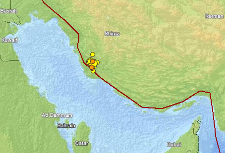
There was actually one foreshock. A mag 3.7 about 6 hours before but that could only possibly be determined after the event. There is possibly another on the 7th
2013-04-07 04:34:08, 28.784, 51.736, 4.2, 30.0, Southern Iran [Ma p]
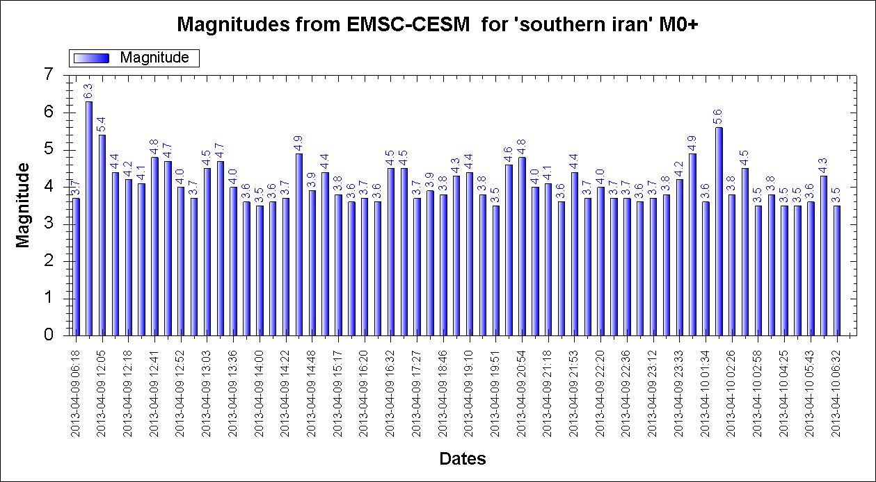
9th to 10th (Click for full size)
There was actually one foreshock. A mag 3.7 about 6 hours before but that could only possibly be determined after the event. There is possibly another on the 7th
2013-04-07 04:34:08, 28.784, 51.736, 4.2, 30.0, Southern Iran [Ma p]
9th to 10th (Click for full size)

continuation of post by PuterMan
61 events so far from EMSC
61 events so far from EMSC
Prov,Date/Time UTC,Latitude,Longitude,Magnitude,Depth(Km),Location
emsc,2013-04-10 06:32:04, 28.462, 51.748, 3.5, 30.0, Southern Iran
emsc,2013-04-10 06:18:38, 28.501, 51.798, 4.3, 30.0, Southern Iran
emsc,2013-04-10 05:43:12, 28.099, 51.717, 3.6, 18.0, Southern Iran
emsc,2013-04-10 05:17:19, 28.076, 51.752, 3.5, 22.0, Southern Iran
emsc,2013-04-10 04:25:17, 28.448, 51.702, 3.5, 30.0, Southern Iran
emsc,2013-04-10 03:35:54, 28.405, 51.656, 3.8, 29.0, Southern Iran
emsc,2013-04-10 02:58:14, 28.529, 52.036, 3.5, 30.0, Southern Iran
emsc,2013-04-10 02:48:04, 28.318, 52.036, 4.5, 8.0, Southern Iran
emsc,2013-04-10 02:26:59, 28.348, 51.893, 3.8, 26.0, Southern Iran
emsc,2013-04-10 01:58:28, 28.440, 51.745, 5.6, 10.0, Southern Iran
emsc,2013-04-10 01:34:15, 28.134, 51.893, 3.6, 10.0, Southern Iran
emsc,2013-04-10 01:29:36, 36.037, 53.535, 3.6, 10.0, Northern Iran
emsc,2013-04-10 01:00:22, 28.422, 51.714, 4.9, 10.0, Southern Iran
emsc,2013-04-09 23:33:34, 28.521, 51.904, 4.2, 10.0, Southern Iran
emsc,2013-04-09 23:19:22, 28.156, 51.524, 3.8, 8.0, Southern Iran
emsc,2013-04-09 23:12:34, 28.375, 51.684, 3.7, 10.0, Southern Iran
emsc,2013-04-09 22:51:09, 28.493, 51.405, 3.6, 36.0, Southern Iran
emsc,2013-04-09 22:36:12, 28.047, 51.493, 3.7, 18.0, Southern Iran
emsc,2013-04-09 22:23:32, 28.311, 51.453, 3.7, 15.0, Southern Iran
emsc,2013-04-09 22:20:45, 28.445, 51.496, 4.0, 25.0, Southern Iran
emsc,2013-04-09 22:15:34, 28.383, 51.483, 3.7, 18.0, Southern Iran
emsc,2013-04-09 21:53:41, 28.427, 51.687, 4.4, 20.0, Southern Iran
emsc,2013-04-09 21:41:49, 28.459, 51.676, 3.6, 19.0, Southern Iran
emsc,2013-04-09 21:18:23, 28.629, 51.707, 4.1, 2.0, Southern Iran
emsc,2013-04-09 21:01:50, 28.301, 51.422, 4.0, 2.0, Southern Iran
emsc,2013-04-09 20:54:21, 28.423, 51.737, 4.8, 40.0, Southern Iran
emsc,2013-04-09 20:06:53, 28.458, 51.638, 4.6, 17.0, Southern Iran
emsc,2013-04-09 19:51:36, 28.409, 51.531, 3.5, 18.0, Southern Iran
emsc,2013-04-09 19:37:09, 28.307, 51.618, 3.8, 14.0, Southern Iran
emsc,2013-04-09 19:10:33, 28.336, 51.588, 4.4, 10.0, Southern Iran
emsc,2013-04-09 18:59:08, 28.474, 51.631, 4.3, 10.0, Southern Iran
emsc,2013-04-09 18:46:51, 28.468, 51.579, 3.8, 17.0, Southern Iran
emsc,2013-04-09 18:03:25, 28.329, 51.659, 3.9, 12.0, Southern Iran
emsc,2013-04-09 17:27:55, 28.412, 51.709, 3.7, 23.0, Southern Iran
emsc,2013-04-09 17:21:00, 28.526, 51.710, 4.5, 10.0, Southern Iran
emsc,2013-04-09 16:32:33, 28.494, 51.650, 4.5, 10.0, Southern Iran
emsc,2013-04-09 16:27:04, 28.382, 51.509, 3.6, 23.0, Southern Iran
emsc,2013-04-09 16:20:24, 28.492, 51.739, 3.7, 30.0, Southern Iran
emsc,2013-04-09 15:26:18, 28.497, 51.748, 3.6, 34.0, Southern Iran
emsc,2013-04-09 15:17:40, 28.546, 51.518, 3.8, 18.0, Southern Iran
emsc,2013-04-09 15:05:46, 28.224, 51.758, 4.4, 10.0, Southern Iran
emsc,2013-04-09 14:48:24, 28.360, 51.878, 3.9, 12.0, Southern Iran
emsc,2013-04-09 14:44:53, 28.420, 51.622, 4.9, 10.0, Southern Iran
emsc,2013-04-09 14:22:27, 28.435, 51.392, 3.7, 35.0, Southern Iran
emsc,2013-04-09 14:16:53, 28.418, 51.512, 3.6, 33.0, Southern Iran
emsc,2013-04-09 14:00:44, 28.294, 51.597, 3.5, 33.0, Southern Iran
emsc,2013-04-09 13:42:12, 28.903, 51.706, 3.6, 36.0, Southern Iran
emsc,2013-04-09 13:36:37, 28.460, 51.642, 4.0, 18.0, Southern Iran
emsc,2013-04-09 13:30:44, 28.524, 51.656, 4.7, 10.0, Southern Iran
emsc,2013-04-09 13:03:26, 28.530, 51.565, 4.5, 15.0, Southern Iran
emsc,2013-04-09 12:58:32, 28.411, 51.426, 3.7, 15.0, Southern Iran
emsc,2013-04-09 12:52:56, 28.487, 51.505, 4.0, 37.0, Southern Iran
emsc,2013-04-09 12:47:51, 28.522, 51.715, 4.7, 30.0, Southern Iran
emsc,2013-04-09 12:41:04, 28.386, 51.664, 4.8, 10.0, Southern Iran
emsc,2013-04-09 12:31:37, 28.400, 51.465, 4.1, 18.0, Southern Iran
emsc,2013-04-09 12:18:11, 28.510, 51.446, 4.2, 36.0, Southern Iran
emsc,2013-04-09 12:15:12, 28.401, 51.564, 4.4, 26.0, Southern Iran
emsc,2013-04-09 12:05:39, 28.436, 51.606, 5.4, 10.0, Southern Iran
emsc,2013-04-09 11:52:50, 28.487, 51.582, 6.3, 10.0, Southern Iran
emsc,2013-04-09 06:18:58, 28.943, 57.900, 3.7, 10.0, Southern Iran
emsc,2013-04-07 04:34:08, 28.784, 51.736, 4.2, 30.0, Southern Iran
Have those been posted? Found this, there was a M8 doublet - 2009 at Samoa/Tonga.
Published on same Nature journal issue, 2 proposals by 2 groups on how the doublet was triggered.
The 1st left a public comment on the 2nd and maintain their view.
Relates to event
Magnitude 8.1 - SAMOA ISLANDS REGION 2009 September 29 17:48:10 UTC
earthquake.usgs.gov/earthquakes/eqinthenews/2009/us2009mdbi/
www.nature.com/nature/journal/v466/n7309/abs/nature09214.html
www.nature.com/nature/journal/v466/n7309/abs/nature09292.html
Published on same Nature journal issue, 2 proposals by 2 groups on how the doublet was triggered.
The 1st left a public comment on the 2nd and maintain their view.
Relates to event
Magnitude 8.1 - SAMOA ISLANDS REGION 2009 September 29 17:48:10 UTC
earthquake.usgs.gov/earthquakes/eqinthenews/2009/us2009mdbi/
www.nature.com/nature/journal/v466/n7309/abs/nature09214.html
The 2009 Samoa–Tonga great earthquake triggered doublet
Nature 466, 964–968 (19 August 2010) doi:10.1038/nature09214
Received 23 February 2010 Accepted 24 May 2010
Thorne Lay,
Charles J. Ammon,
Hiroo Kanamori,
Luis Rivera,
Keith D. Koper
& Alexander R. Hutko
Department of Earth and Planetary Sciences, University of California Santa Cruz, Santa Cruz, California 95064, USA
Thorne Lay
Department of Geosciences, The Pennsylvania State University, 440 Deike Building, University Park, Pennsylvania 16802, USA
Charles J. Ammon
Seismological Laboratory, California Institute of Technology, MS 252-21, Pasadena, California 91125, USA
Hiroo Kanamori
Institut de Physique du Globe de Strasbourg, UMR7516, Université de Strasbourg/CNRS, France
Luis Rivera
Department of Earth and Atmospheric Sciences, Saint Louis University, 3642 Lindell Boulevard, St Louis, Missouri 63108, USA
Keith D. Koper
US Geological Survey, NEIC, MS 966 Box 2504, DFC, Denver, Colorado 80225, USA
Alexander R. Hutko
Great earthquakes (having seismic magnitudes of at least 8) usually involve abrupt sliding of rock masses at a boundary between tectonic plates. Such interplate ruptures produce dynamic and static stress changes that can activate nearby intraplate aftershocks, as is commonly observed in the trench-slope region seaward of a great subduction zone thrust event1, 2, 3, 4. The earthquake sequence addressed here involves a rare instance in which a great trench-slope intraplate earthquake triggered extensive interplate faulting, reversing the typical pattern and broadly expanding the seismic and tsunami hazard. On 29 September 2009, within two minutes of the initiation of a normal faulting event with moment magnitude 8.1 in the outer trench-slope at the northern end of the Tonga subduction zone, two major interplate underthrusting subevents (both with moment magnitude 7.8), with total moment equal to a second great earthquake of moment magnitude 8.0, ruptured the nearby subduction zone megathrust. The collective faulting produced tsunami waves with localized regions of about 12 metres run-up that claimed 192 lives in Samoa, American Samoa and Tonga. Overlap of the seismic signals obscured the fact that distinct faults separated by more than 50 km had ruptured with different geometries, with the triggered thrust faulting only being revealed by detailed seismic wave analyses. Extensive interplate and intraplate aftershock activity was activated over a large region of the northern Tonga subduction zone.
2010-08-19 11:56 AM comment #12882
Thorne Lay said:
Subsequent to publication, and motivated by the GPS and tsunami models of the paper by Beavan et al., we further examined the seismic ground motions preceding the arrival of the P waves from the normal faulting event. Stacking F-Net stations in Japan and Transportable Array stations in the USA indicates no visible precursory seismic radiation, and assuming a 200 s time scale, we can bound any precursory seismic radiation to less than a magnitude 6.5 event. Since we account for all of the seismic moment needed to explain the GPS observations with thrust faulting after the normal faulting event, we continue to prefer the notion that the thrust faulting was triggered by shaking from the normal faulting.
www.nature.com/nature/journal/v466/n7309/abs/nature09292.html
Near-simultaneous great earthquakes at Tongan megathrust and outer rise in September 2009
Nature 466, 959–963 (19 August 2010) doi:10.1038/nature09292
Received 21 January 2010 Accepted 21 June 2010
J. Beavan,
X. Wang,
C. Holden,
K. Wilson,
W. Power,
G. Prasetya,
M. Bevis
& R. Kautoke
GNS Science, PO Box 30368, Lower Hutt 5040, New Zealand
J. Beavan,
X. Wang,
C. Holden,
K. Wilson,
W. Power &
G. Prasetya
School of Earth Sciences, Ohio State University, Columbus, Ohio 43210, USA
M. Bevis
Ministry of Lands, Survey, Natural Resources and Environment, PO Box 5, Nuku’alofa, Tonga
R. Kautoke
The Earth’s largest earthquakes and tsunamis are usually caused by thrust-faulting earthquakes on the shallow part of the subduction interface between two tectonic plates, where stored elastic energy due to convergence between the plates is rapidly released1, 2. The tsunami that devastated the Samoan and northern Tongan islands on 29 September 2009 was preceded by a globally recorded magnitude-8 normal-faulting earthquake in the outer-rise region, where the Pacific plate bends before entering the subduction zone. Preliminary interpretation suggested that this earthquake was the source of the tsunami3. Here we show that the outer-rise earthquake was accompanied by a nearly simultaneous rupture of the shallow subduction interface, equivalent to a magnitude-8 earthquake, that also contributed significantly to the tsunami. The subduction interface event was probably a slow earthquake with a rise time of several minutes that triggered the outer-rise event several minutes later. However, we cannot rule out the possibility that the normal fault ruptured first and dynamically triggered the subduction interface event. Our evidence comes from displacements of Global Positioning System stations and modelling of tsunami waves recorded by ocean-bottom pressure sensors, with support from seismic data and tsunami field observations. Evidence of the subduction earthquake in global seismic data is largely hidden because of the earthquake’s slow rise time or because its ground motion is disguised by that of the normal-faulting event. Earthquake doublets where subduction interface events trigger large outer-rise earthquakes have been recorded previously4, but this is the first well-documented example where the two events occur so closely in time and the triggering event might be a slow earthquake. As well as providing information on strain release mechanisms at subduction zones, earthquakes such as this provide a possible mechanism for the occasional large tsunamis generated at the Tonga subduction zone5, where slip between the plates is predominantly aseismic6.
edit on 10-4-2013 by wujotvowujotvowujotvo because: (no reason given)
geofon.gfz-potsdam.de...
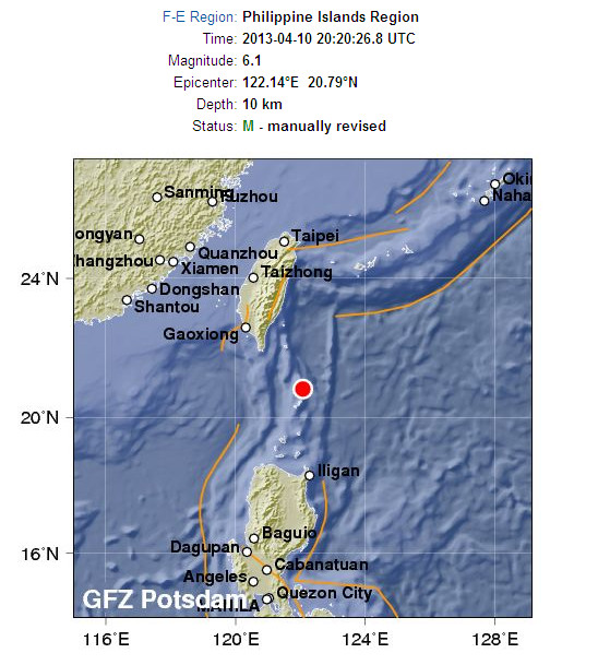
Not come up in USGS yet. 5.8 in EMSC
USGS and EMSC now both 6.1
Magnitude 6.1 - Batan Islands Region. Philippines
Location in Google Maps
- Date-Time: Wednesday, April 10, 2013 @ 20:20:27 UTC
- Earthquake location: 20.852°N, 122.121°E,
- Earthquake depth: 15.9 km
- Distances:
29km (18mi) ENE of Itbayat, Philippines
191km (118mi) SE of Hengchun, Taiwan
233km (144mi) SSE of Taitung City, Taiwan
270km (167mi) SE of Kaohsiung, Taiwan
701km (435mi) N of Manila, Philippines
- Event ID: usb000g4ca
Derived from Event Data Source: USGS
Powered by QVSData
edit on 10/4/2013 by PuterMan because: (no reason given)
reply to post by PuterMan
Do you know if there have been any tsunami warnings?
Lot's of small Islands there about!
Do you know if there have been any tsunami warnings?
Lot's of small Islands there about!
reply to post by azureskys
No tsunami warnings that I can see yet.
Interestingly GFZ has now revised again and brought it down to 5.9 Mw
This is probably going to drop. The USGS have it as 5.8 Mw in the body moment tensor. Just a matter of how many days it takes!
EMSC have just come down to 6.0 Mw
No tsunami warnings that I can see yet.
Interestingly GFZ has now revised again and brought it down to 5.9 Mw
This is probably going to drop. The USGS have it as 5.8 Mw in the body moment tensor. Just a matter of how many days it takes!
EMSC have just come down to 6.0 Mw
edit on 10/4/2013 by PuterMan because: (no reason given)
There was also one in Honduras...power and internet outages, but no reports of injuries as yet.
Most important Earthquake Data:
Magnitude : 5.4
Local Time (conversion only below land) : 2013-04-10 13:14:04
GMT/UTC Time : 2013-04-10 19:14:04
Depth (Hypocenter) : 10 km
Depth and Magnitude updates in the list below.
earthquake-report.com...
Rainbows
Jane
Most important Earthquake Data:
Magnitude : 5.4
Local Time (conversion only below land) : 2013-04-10 13:14:04
GMT/UTC Time : 2013-04-10 19:14:04
Depth (Hypocenter) : 10 km
Depth and Magnitude updates in the list below.
earthquake-report.com...
Rainbows
Jane
update to post by PuterMan
Amazingly USGS have already devalued the quake and it is now 5.8 Mw. EMSC sits alone in the M6 bracket.
Amazingly USGS have already devalued the quake and it is now 5.8 Mw. EMSC sits alone in the M6 bracket.
sorry been busy at work this week
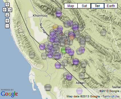
interactive map of Khormog 6.2Ml aftershocks according to IIEES
67 aftershocks, only one mag two, a 2.8
I took them off their main list, will have a look later at the search results, that goes down to 2.5
interactive map of Khormog 6.2Ml aftershocks according to IIEES
67 aftershocks, only one mag two, a 2.8
I took them off their main list, will have a look later at the search results, that goes down to 2.5
reply to post by wujotvowujotvowujotvo
yeah I heard they were two 7.9Mw's
a while back
they still haven't recovered on the main island still houses in piles of debris from the tsunami.
yeah I heard they were two 7.9Mw's
a while back
they still haven't recovered on the main island still houses in piles of debris from the tsunami.
My mobile phone does not have a camera and does not connect to the internet. It is what is says, a mobile phone and as a grumpy old man that's the way
I like it BUT for those of you whose mobile phone takes pictures, cooks the dinner, cleans the house and reports your whereabouts to the world at all
times including to the Gubbermint, you may like this USGS beta site - a list for mobiles
earthquake.usgs.gov...
Actually not a bad quick list for the PC as well.
By the way they have finally sorted out the KML file for Google Earth which now goes to the new pages instead of the old ones. You will find it at the bottom of the feeds page.
Alternatively just download it from this link USGS Earthquakes KML Feed
earthquake.usgs.gov...
Actually not a bad quick list for the PC as well.
edit on 11/4/2013 by PuterMan because: grr spelling. Can the mobile phone sort that out as well?
By the way they have finally sorted out the KML file for Google Earth which now goes to the new pages instead of the old ones. You will find it at the bottom of the feeds page.
Alternatively just download it from this link USGS Earthquakes KML Feed
edit on 11/4/2013 by PuterMan because: (no reason given)
The USGS have created a poster for the Iranian earthquake if anyone is interested
earthquake.usgs.gov...
earthquake.usgs.gov...
reply to post by PuterMan
Another mixed signal on boundaries.
In the poster the plate edge is way north and they say
their Real Time gives much nearer to shore and to the earthquake, implying not INTRA but INTER
Another mixed signal on boundaries.
In the poster the plate edge is way north and they say
intraplate event, occurring almost 300 km south of the main plate boundary, and since the event likely did not break the surface, precise identification of the causative fault is difficult at this time
their Real Time gives much nearer to shore and to the earthquake, implying not INTRA but INTER
reply to post by muzzy
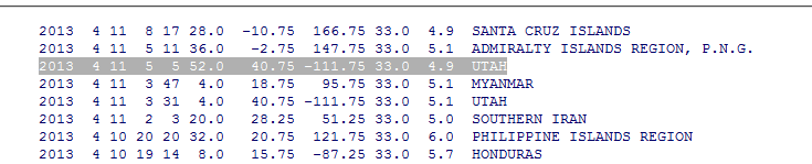
Huh? A 5.1 & a 4.9!
I'm not seeing anything listed anywhere else though!
Wonder what's up? Wonder if it's on the seismos?
I was surprised to see the 2.6 in Hawaii near Oahu too!
I used to live there, didn't remember any that close.
The 1973 to present map doesn't show any either!
earthquake.usgs.gov...
Things that make you say hmmm.....
WOQ
In a hurry, but I did find this one, can't see it!
Especially two that big!
www.seis.utah.edu...
edit on 11-4-2013 by wasobservingquietly because: (no reason given)
reply to post by wujotvowujotvowujotvo
Yeah thats weird, I use the USGS Plate Boundries KML file on my maps and it shows it in the same place as the usgsinteractivemapthingy image you posted for this quake.
Mag 6.1 was 15km north of the Continental Convergent Boundary according to IIEES
updated interactive map of the IIEES data results with elapsed time in the popup tags below;
[color=lime](click image for interactive map, opens in new tab/window)
edit on 11-4-2013 by muzzy because: add new map
reply to post by wasobservingquietly
TCU.UU..HHZ.2013.101
Stuff did happen.
Here is a bigger version - click the image
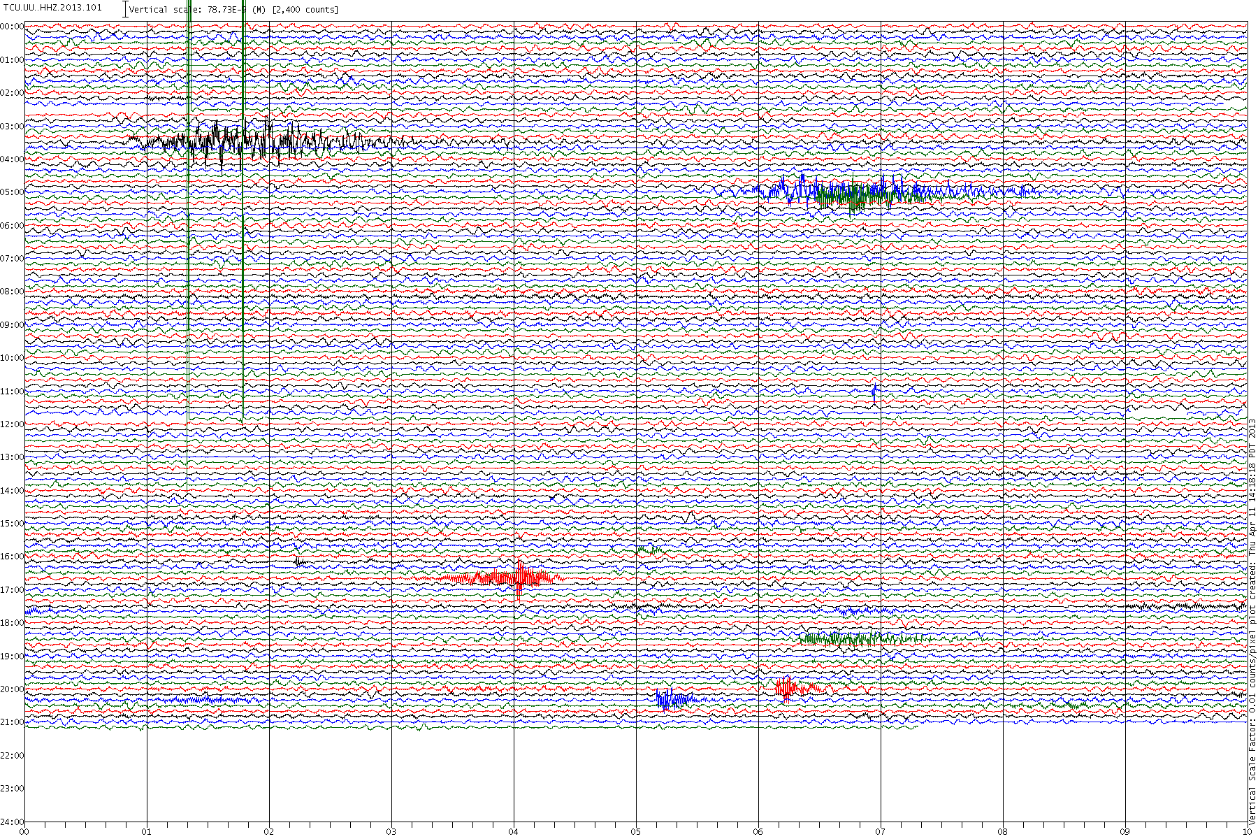
A 'surface wave' it might be, but I don't think it is an earthquake. It actually looks more like a fluid event.
I am going to have a little download of the data and see what I can hear.
TCU.UU..HHZ.2013.101
Stuff did happen.
Here is a bigger version - click the image

A 'surface wave' it might be, but I don't think it is an earthquake. It actually looks more like a fluid event.
I am going to have a little download of the data and see what I can hear.
edit on 11/4/2013 by PuterMan because: (no reason given)
reply to post by PuterMan
The seismos that show the 'event' the closest are those that are pretty much ON the great salt lake.
SNUT.UU..EHZ.2013.101
NAIU.UU..EHZ.2013.101
SAIU.UU..EHZ.2013.101
Where a station has a normal and an accelerometer (N) channel the N channel is not really showing anything.
I know nothing about the great salt lake. Could this be an ice related event?
reply to post by PuterMan
thanks for checking that out, definitely something happened.
When I seen it on LDEO and not USGS I came here expecting the Americans to be all over it.4.9 and 5.1 is pretty big for an ice crack.
Does the Salt Lake even get ice? no idea.
Hmmm.
thanks for checking that out, definitely something happened.
When I seen it on LDEO and not USGS I came here expecting the Americans to be all over it.4.9 and 5.1 is pretty big for an ice crack.
Does the Salt Lake even get ice? no idea.
Hmmm.
new topics
-
Las Vegas UFO Spotting Teen Traumatized by Demon Creature in Backyard
Aliens and UFOs: 3 hours ago -
2024 Pigeon Forge Rod Run - On the Strip (Video made for you)
Automotive Discussion: 4 hours ago -
Gaza Terrorists Attack US Humanitarian Pier During Construction
Middle East Issues: 4 hours ago -
The functionality of boldening and italics is clunky and no post char limit warning?
ATS Freshman's Forum: 5 hours ago -
Meadows, Giuliani Among 11 Indicted in Arizona in Latest 2020 Election Subversion Case
Mainstream News: 6 hours ago -
Massachusetts Drag Queen Leads Young Kids in Free Palestine Chant
Social Issues and Civil Unrest: 6 hours ago -
Weinstein's conviction overturned
Mainstream News: 7 hours ago -
Supreme Court Oral Arguments 4.25.2024 - Are PRESIDENTS IMMUNE From Later Being Prosecuted.
Above Politics: 9 hours ago -
Krystalnacht on today's most elite Universities?
Social Issues and Civil Unrest: 9 hours ago -
Chris Christie Wishes Death Upon Trump and Ramaswamy
Politicians & People: 9 hours ago
top topics
-
Krystalnacht on today's most elite Universities?
Social Issues and Civil Unrest: 9 hours ago, 9 flags -
Supreme Court Oral Arguments 4.25.2024 - Are PRESIDENTS IMMUNE From Later Being Prosecuted.
Above Politics: 9 hours ago, 8 flags -
Weinstein's conviction overturned
Mainstream News: 7 hours ago, 7 flags -
University of Texas Instantly Shuts Down Anti Israel Protests
Education and Media: 12 hours ago, 6 flags -
Massachusetts Drag Queen Leads Young Kids in Free Palestine Chant
Social Issues and Civil Unrest: 6 hours ago, 5 flags -
Gaza Terrorists Attack US Humanitarian Pier During Construction
Middle East Issues: 4 hours ago, 5 flags -
Meadows, Giuliani Among 11 Indicted in Arizona in Latest 2020 Election Subversion Case
Mainstream News: 6 hours ago, 5 flags -
Las Vegas UFO Spotting Teen Traumatized by Demon Creature in Backyard
Aliens and UFOs: 3 hours ago, 3 flags -
Chris Christie Wishes Death Upon Trump and Ramaswamy
Politicians & People: 9 hours ago, 2 flags -
2024 Pigeon Forge Rod Run - On the Strip (Video made for you)
Automotive Discussion: 4 hours ago, 2 flags
active topics
-
University of Texas Instantly Shuts Down Anti Israel Protests
Education and Media • 202 • : CriticalStinker -
British TV Presenter Refuses To Use Guest's Preferred Pronouns
Education and Media • 163 • : rigel4 -
SHORT STORY WRITERS CONTEST -- April 2024 -- TIME -- TIME2024
Short Stories • 23 • : DontTreadOnMe -
Meadows, Giuliani Among 11 Indicted in Arizona in Latest 2020 Election Subversion Case
Mainstream News • 13 • : xuenchen -
-@TH3WH17ERABB17- -Q- ---TIME TO SHOW THE WORLD--- -Part- --44--
Dissecting Disinformation • 684 • : daskakik -
Any one suspicious of fever promotions events, major investor Goldman Sachs card only.
The Gray Area • 10 • : Caver78 -
Chris Christie Wishes Death Upon Trump and Ramaswamy
Politicians & People • 21 • : WhitewaterSquirrel -
Supreme Court Oral Arguments 4.25.2024 - Are PRESIDENTS IMMUNE From Later Being Prosecuted.
Above Politics • 78 • : chr0naut -
The Acronym Game .. Pt.3
General Chit Chat • 7750 • : bally001 -
Las Vegas UFO Spotting Teen Traumatized by Demon Creature in Backyard
Aliens and UFOs • 7 • : rickymouse