It looks like you're using an Ad Blocker.
Please white-list or disable AboveTopSecret.com in your ad-blocking tool.
Thank you.
Some features of ATS will be disabled while you continue to use an ad-blocker.

Quake Watch 2013
page: 61share:
reply to post by Olivine
Thanks to you and Puterman for all the info.... much needed and I am not confused any longer. Whooo Hoooo!
Wetcoast where are you located exactly? California I'm assuming?
Thanks to you and Puterman for all the info.... much needed and I am not confused any longer. Whooo Hoooo!
Wetcoast where are you located exactly? California I'm assuming?
Here is an interesting article posted at LiveScience concerning
foreshocks along plate boundary faults. The research paper that it references is behind a paywall at
nature geoscience.
Does this possibly describe what we are seeing in southern California along the San Jacinto fault?
While the pattern for each plate boundary earthquake was unique, on average, the seismicity along the faults was nearly constant until about two months before a big earthquake, when there was a small but noticeable increase, the researchers found.
The increase became more pronounced about 20 days before the main event. Earthquake frequency continued accelerating about two days before, then a few hours before, and kept increasing until the final convulsion, the study found.
Does this possibly describe what we are seeing in southern California along the San Jacinto fault?
reply to post by Olivine
What do you think? Feel free to reason and rationalize "out loud" on here. I won't mind listening to (reading) what you have to say.
I can only say, time will tell. I have no idea how to tell if there has been an uptick in activity or not. It seems as though there is, however I have no data to back it up.
Does this possibly describe what we are seeing in southern California along the San Jacinto fault?
What do you think? Feel free to reason and rationalize "out loud" on here. I won't mind listening to (reading) what you have to say.
I can only say, time will tell. I have no idea how to tell if there has been an uptick in activity or not. It seems as though there is, however I have no data to back it up.
reply to post by MamaJ
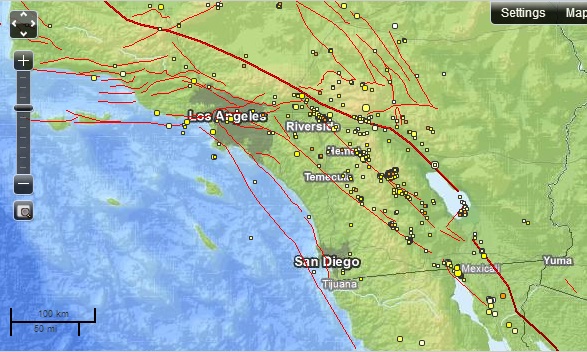
I haven't looked at the numbers either MamaJ. But it does look and feel like the small quakes in SoCal have been on the rise. Here is the USGS map of the area over the past month--mag 1.0 and larger. (over 900 eqs).
There seems to have been mag 6.2 200 kms deep in Guatemala. Only mild shaking reported so far. That's good.
I was not thaaaaat far of with puerto rico damn... I should have posted "near Gulf of Mexico"
this is where things get lost in the conversion.
seems a big quake with the bold 6.2 red text
but its only a 5.2ML according to USGS
Mw = 6.2 (72), mb = 6.1 (453) ML = 5.2 ( 2)
and a 5.6ML according to INETER ( Nicaragua)
13/03/25 17:02:17 14.934N 90.027W 15.0 5.6ML
I wonder how many more mag 6's we would have here on the books if all the 5's were translated into mb and Mw?
GFZ are running with 5.8 for now probably mb
yeah the Russians haven't even bothered to convert it to Ms, they have 5.6mb too
Chinese say 6.1Ms
always good to get a few quotes and not go for the highest bidder
edit on 25-3-2013 by muzzy because: (no reason given)
edit
on 25-3-2013 by muzzy because: (no reason given)
M6.2 - 6km NNW of San Jose Pinula, Guatemala
2013-03-25 23:02:14 UTC
2013-03-25 23:02:14 UTC
2013-03-25 17:02:14 UTC-06:00 at epicenter
2013-03-25 19:02:14 UTC-04:00 system time
Location
14.599°N 90.428°W depth=200.5km (124.6mi)
Nearby Cities
6km (4mi) NNW of San Jose Pinula, Guatemala
8km (5mi) ENE of Santa Catarina Pinula, Guatemala
10km (6mi) ESE of Guatemala City, Guatemala
10km (6mi) SW of Palencia, Guatemala
14km (9mi) SSE of Chinautla, Guatemala
(Reuters) - A powerful earthquake struck Guatemala close to the capital city on Monday, though emergency services said there were no initial reports of damage or injuries.
The epicenter of the 6.2 magnitude earthquake, initially reported as a magnitude 5.8, was only 6 miles southeast of Guatemala City but it was at a depth of 124.6 miles, lessening its effect.
David de Leon, a spokesman for Guatemala's emergency agency, CONRED, said he had no reports of damage or victims.
2013-03-25 23:02:14 UTC
2013-03-25 23:02:14 UTC
2013-03-25 17:02:14 UTC-06:00 at epicenter
2013-03-25 19:02:14 UTC-04:00 system time
Location
14.599°N 90.428°W depth=200.5km (124.6mi)
Nearby Cities
6km (4mi) NNW of San Jose Pinula, Guatemala
8km (5mi) ENE of Santa Catarina Pinula, Guatemala
10km (6mi) ESE of Guatemala City, Guatemala
10km (6mi) SW of Palencia, Guatemala
14km (9mi) SSE of Chinautla, Guatemala
(Reuters) - A powerful earthquake struck Guatemala close to the capital city on Monday, though emergency services said there were no initial reports of damage or injuries.
The epicenter of the 6.2 magnitude earthquake, initially reported as a magnitude 5.8, was only 6 miles southeast of Guatemala City but it was at a depth of 124.6 miles, lessening its effect.
David de Leon, a spokesman for Guatemala's emergency agency, CONRED, said he had no reports of damage or victims.
edit on 25-3-2013 by
kennvideo because: more info
Canary Islands can pose a grave danger as they have in the past.
If El Hierro blows the tsunami would only take 8 hours to hit US East Coast
earthquake-report.com...
Lots of info at this link please see whats happening!
earthquake-report.com...
If El Hierro blows the tsunami would only take 8 hours to hit US East Coast
earthquake-report.com...
El Hierro Volcano activity report – +200 earthquakes listed so far today, in reality much more
2013-03-25 21:07 UTC
- A new set of stronger earthquakes has started at 20:55 UTC. They are not yet listed but we expect them to be in the M3 to M3.5 range.
- Badly predicted as it was finally M3.8 at a depth of 13 km. Epicenter approx. 10 km out in the Ocean.
- So far 40 earthquakes of M3.0 or more today
- 193 earthquakes listed by IGN so far today BUT in reality there are hundreds of earthquakes, even more of them below M2 than above it.
Lots of info at this link please see whats happening!
earthquake-report.com...
reply to post by Olivine
Well, there we go huh? I wonder if it will be in the 5's before its over with?
The anticipation is still around though...... time will tell.
Well, there we go huh? I wonder if it will be in the 5's before its over with?
The anticipation is still around though...... time will tell.
reply to post by azureskys
I have noticed that you posted this on TA's thread about La Palma.....now you are getting it muddled up here too.
El Hierro has submarine volcano forming, ie under the sea. La Palma/ Cumbre Viejo is another island entirely about 50 miles appart. What will happen there is not even volcanic.
Rainbows
Jane
reply to post by angelchemuel
Ok.
On TrueAmerican's thread, I only posted the link because he/she made reference to El Hirro as a possible
explanation for his/her findings.
The link states over 200 earthquakes 25th of March.
Operative word : earthquakes
I don't believe I am "getting it muddled up here too" as
this is a thread on "quakes isn't it ?
Ok.
On TrueAmerican's thread, I only posted the link because he/she made reference to El Hirro as a possible
explanation for his/her findings.
Originally posted by TrueAmerican
Originally posted by whatnext21
And here is a link to latest activity reporting
www.volcano-news.com...
That's funny, and not one single WORD about what I am reporting in this thread. I dunno, it's possible no one else has caught it... But, that is extremely unlikely. Scientists are too darn smart these days, and have too many accurate tools NOT to see it.
Seismicity, and even tremor, is not necessarily indicative of an eruption. Happens all the time at many volcanoes all over the world. But once tremor starts, it usually raises some eyebrows, and initiates further checking, and often further testing, for ground deformation and increased gas emissions, as well as thermal signatures, hydrothermal tests, and more. More? Yeah. Magnetic anomalies, for example. So there is lots that can be done, and the IGN has an extensive website, with all kinds of stuff like that. I've been poking around to try and find out more. But the focus right now is on El Hierro seismicity.
So yeah, anyone want to try and help, then poke around their site and see what you can come up with regarding any of the above mentioned other symptoms. If this is tremor at La Palma, which I believe it is, it still is not so strong and persistent that I am all that really worried about anything imminent. And also, I can't say that I've seen any recent seismicity that usually accompanies such tremor- although I stress that could be easily hidden in what is perceived to be El Hierro seismicity- unless you had access to the raw data and were looking at zoomed in waveforms where you can see the separation of P&S waves more clearly. El Hierro is so close to make that distinction, you would really need the raw data. And I don't have access to that. Scientists would though.
Since tremor usually indicates some kind of fluid or gas movement, these events could be indicative of a deep intrusion, under or near La Palma, and the addition of more magma/gas. Could be it is related somehow to what's going on at El Hierro.
The link states over 200 earthquakes 25th of March.
Operative word : earthquakes
I don't believe I am "getting it muddled up here too" as
this is a thread on "quakes isn't it ?
edit on 26-3-2013 by azureskys because: added on(no reason given)
edit on 26-3-2013 by
azureskys because: added quote
reply to post by azureskys
No, I am going to disagree again...You El Hierro post IMHO would be better place on this thread Volcano Watch 2013...found here
www.abovetopsecret.com...
or even here
www.abovetopsecret.com...
But that is just my view. At least your post is getting peoples attention besides mine
Rainbows
Jane
No, I am going to disagree again...You El Hierro post IMHO would be better place on this thread Volcano Watch 2013...found here
www.abovetopsecret.com...
or even here
www.abovetopsecret.com...
But that is just my view. At least your post is getting peoples attention besides mine
Rainbows
Jane
edit on 26-3-2013 by angelchemuel because: (no reason given)
Type: Earthquake
2 hours ago
Magnitude: 5.5
DateTime: Tuesday March 26 2013, 13:04:48 UTC
Region: offshore Oaxaca, Mexico
Depth: 10 km
Source: USGS Feed
quakes.globalincidentmap.com...
Type: Earthquake
2 hours ago
Magnitude: 5.1
DateTime: Tuesday March 26 2013, 13:12:19 UTC
Region: Oaxaca, Mexico
Depth: 12.9 km
Source: USGS Feed
quakes.globalincidentmap.com...
Originally posted by azureskys
reply to post by angelchemuel
Ok.
On TrueAmerican's thread, I only posted the link because he/she made reference to El Hirro as a possible
explanation for his/her findings.
The link states over 200 earthquakes 25th of March.
Operative word : earthquakes
I don't believe I am "getting it muddled up here too" as
this is a thread on "quakes isn't it ?
reply to post by angelchemuel
No, I am going to disagree again...You El Hierro post IMHO would be better place on this thread Volcano Watch 2013...
I'm not an earthquake expert.... just a layman. To me, it seems that the discussion is a chicken and egg scenario:
Did the earthquake cause the volcanic activity, or did the magna flow in the volcano create the earthquake?
Does this sound close?
edit on 26/3/2013 by MarkJS because: (no reason given)
posted this over on the QW2009 pages, seemed more appropriate over there
L'Aquila page finally published, started it about 6 weeks ago.
483 foreshocks in the 90 days prior
17,039 aftershocks over 9 months
22 maps
4 graphs
1 table ............................ read more here
I took this awesome screenshot at 5km above the ground, you can almost see the ground shaking
 (finger is the 6.3Mw)
 reply to post by MamaJ
I live on Vancouver Island. I have been feeling quite a few "micro-quakes" over the last few months(not everyday but at least a couple of times a week).
I live on Vancouver Island. I have been feeling quite a few "micro-quakes" over the last few months(not everyday but at least a couple of times a week).
reply to post by azureskys
Have a read back on the later Volcano Watch 2011 pages, starts about here, El Hierro had thousands of small quakes then and all that happened was some jacuzzi action in the sea
I covered it for a while, 28/09/2011-05/11/2011 here Volcanic Tremors (Hierro) click "Newer Entries>>>" for more pages with maps and graphs, the way its set up it goes backwards from page 7 (the start) to page 1 (the end)
As has been said so many times before on ATS, El Hierro is not La Palma where the landslide/collapse story relates to, and even that story has been discredited.
IGN data for the Canaries goes back to 22/05/1964, 19,698 terremotos (quakes), of those 17,993 since 19/07/201 at Hierro, I might plot the rest of those one day on those Tremors journal pages.
I notice Armand (earthquake-report) didn't put a link on to this page of IGN, has the Hierro maps, but not interactive.www.ign.es...
Have a read back on the later Volcano Watch 2011 pages, starts about here, El Hierro had thousands of small quakes then and all that happened was some jacuzzi action in the sea
I covered it for a while, 28/09/2011-05/11/2011 here Volcanic Tremors (Hierro) click "Newer Entries>>>" for more pages with maps and graphs, the way its set up it goes backwards from page 7 (the start) to page 1 (the end)
As has been said so many times before on ATS, El Hierro is not La Palma where the landslide/collapse story relates to, and even that story has been discredited.
edit on 26-3-2013 by muzzy because: (no reason given)
IGN data for the Canaries goes back to 22/05/1964, 19,698 terremotos (quakes), of those 17,993 since 19/07/201 at Hierro, I might plot the rest of those one day on those Tremors journal pages.
I notice Armand (earthquake-report) didn't put a link on to this page of IGN, has the Hierro maps, but not interactive.www.ign.es...
edit on 26-3-2013 by muzzy because: (no reason given)
not that far from me, across on the other side of Cook Strait, didn't feel it though, I think I was asleep
Public ID 2013p227990
Universal Time March 26 2013 at 8:33:26
NZ Daylight Time Tuesday, March 26 2013 at 9:33:26 pm
Latitude, Longitude -41.67, 173.76
Intensity ? light
Focal Depth 63 km
Magnitude 4.7
Location 25 km south-west of Blenheim
Agency WEL(GNS_Primary)
Status ? reviewed
www.geonet.org.nz...
reply to post by azureskys
Yup, it is,and discussion of quakes on El Herro is definitely 'on topic'. You are however misunderstanding what 'Little Miss Rainbows' is saying.
You, along with many others, are refer to Cumbre Veija and El Hierro in the same breath as one and the same thing. They are not.
The 'muddling' comes from this statement:
This appears to be a combination of the relatively peaceful volcanic activity at El Hierro and the flank collapse at Cumbre Veija which were it to happen again would result in a 'tsunami' of
I don't believe I am "getting it muddled up here too" as
this is a thread on "quakes isn't it ?
Yup, it is,and discussion of quakes on El Herro is definitely 'on topic'. You are however misunderstanding what 'Little Miss Rainbows' is saying.
You, along with many others, are refer to Cumbre Veija and El Hierro in the same breath as one and the same thing. They are not.
The 'muddling' comes from this statement:
If El Hierro blows the tsunami would only take 8 hours to hit US East Coast
This appears to be a combination of the relatively peaceful volcanic activity at El Hierro and the flank collapse at Cumbre Veija which were it to happen again would result in a 'tsunami' of
reply to post by muzzy
I also covered it for a while. Some links to my data here
Too many other things to attend to at present so i shall not be covering it again unless it gets really interesting.
I also covered it for a while. Some links to my data here
Too many other things to attend to at present so i shall not be covering it again unless it gets really interesting.
new topics
-
God's Righteousness is Greater than Our Wrath
Religion, Faith, And Theology: 1 hours ago -
Electrical tricks for saving money
Education and Media: 4 hours ago -
VP's Secret Service agent brawls with other agents at Andrews
Mainstream News: 6 hours ago -
Sunak spinning the sickness figures
Other Current Events: 6 hours ago -
Nearly 70% Of Americans Want Talks To End War In Ukraine
Political Issues: 7 hours ago -
Late Night with the Devil - a really good unusual modern horror film.
Movies: 8 hours ago -
Cats Used as Live Bait to Train Ferocious Pitbulls in Illegal NYC Dogfighting
Social Issues and Civil Unrest: 10 hours ago
top topics
-
Florida man's trip overseas ends in shock over $143,000 T-Mobile phone bill
Social Issues and Civil Unrest: 17 hours ago, 8 flags -
Cats Used as Live Bait to Train Ferocious Pitbulls in Illegal NYC Dogfighting
Social Issues and Civil Unrest: 10 hours ago, 8 flags -
VP's Secret Service agent brawls with other agents at Andrews
Mainstream News: 6 hours ago, 8 flags -
Electrical tricks for saving money
Education and Media: 4 hours ago, 4 flags -
Bobiverse
Fantasy & Science Fiction: 17 hours ago, 3 flags -
HORRIBLE !! Russian Soldier Drinking Own Urine To Survive In Battle
World War Three: 14 hours ago, 3 flags -
Nearly 70% Of Americans Want Talks To End War In Ukraine
Political Issues: 7 hours ago, 3 flags -
Sunak spinning the sickness figures
Other Current Events: 6 hours ago, 3 flags -
Late Night with the Devil - a really good unusual modern horror film.
Movies: 8 hours ago, 2 flags -
The Good News According to Jesus - Episode 1
Religion, Faith, And Theology: 12 hours ago, 1 flags
active topics
-
Electrical tricks for saving money
Education and Media • 4 • : Lumenari -
Cats Used as Live Bait to Train Ferocious Pitbulls in Illegal NYC Dogfighting
Social Issues and Civil Unrest • 19 • : WeMustCare -
VP's Secret Service agent brawls with other agents at Andrews
Mainstream News • 38 • : SchrodingersRat -
New whistleblower Jason Sands speaks on Twitter Spaces last night.
Aliens and UFOs • 54 • : Ophiuchus1 -
DONALD J. TRUMP - 2024 Candidate for President - His Communications to Americans and the World.
2024 Elections • 514 • : WeMustCare -
The Acronym Game .. Pt.3
General Chit Chat • 7744 • : bally001 -
Truth Social goes public, be careful not to lose your money
Mainstream News • 128 • : Astyanax -
Sunak spinning the sickness figures
Other Current Events • 5 • : glen200376 -
SETI chief says US has no evidence for alien technology. 'And we never have'
Aliens and UFOs • 44 • : MikeDeGrasseTyson -
HORRIBLE !! Russian Soldier Drinking Own Urine To Survive In Battle
World War Three • 31 • : budzprime69