It looks like you're using an Ad Blocker.
Please white-list or disable AboveTopSecret.com in your ad-blocking tool.
Thank you.
Some features of ATS will be disabled while you continue to use an ad-blocker.

Quake Watch 2013
page: 56share:
I can explain the Nied4maps+MeSO-netSound test as far as I know.
and I don't believe in this earthquake prediction site, but I would not say it is somehow totally off to say that there will be a big one soon. maybe not today, but give it 2 or 3 days and something over 6.5 will happen. it is no magic or prediction. it is normal somewhere in Japan
btw. If I predict something, it would be 7.0+ between papua new guinea and santa cruz within 5 days from now
About the monitor alarm sound Strong (7/11/2011)]
If the condition becomes colored more than 20%, or more green points observed within the 15x15 pixels around the point that is the green or yellow is the center of the display frame above lasted for more than four seconds, Earthquake alarm will sound to determine the occurrence. Also displays the alert mark at the same time.
Please note that for example, when widespread strong shaking, but there are things that the alarm will sound intermittently for a long period of time.
Rather than by way of earthquake early warning, alarm sound, so this is what you are to judge from the number of strong-motion color on the monitor only, please refer to each institution, such as those of the actual earthquake information.
About the audio (2011/6/29 ~)]
Has put out a sine wave of 30Hz ~ 10kHz in proportion to the (absolute value) of the amplitude of the vibration waveform (Rch) Ibaraki (Lch) · Chiba (Center) · Tokyo MeSO-net.
Vibration data that is being supplied by MeSO-net is 20 seconds sample /, it is changing the pitch every 0.05 seconds.
The higher the sound is now shaking big lot.
About the graph of MeSO-net]
Graph Eventhough "14" factor drawing is the default for confusing shaking detailed in "14", here is "lower 11" upper graph is based on a state that increases the sensitivity slightly as "13".
The upper and lower graphs in time and amplitude the same data are displayed only different.
It is a unit of amplitude, especially since there is no notation on page Eventhough, this does not know what it's cm, width or shaking.
"In addition, Ibaraki" "Chiba" "Tokyo" in the upstream (left graph), "(junior high Yamanakako) Yamanashi Lake Yamanaka" "(Shonangakuen) Fujisawa, Kanagawa," "(Elementary School Bessho) Hachioji, Tokyo" Show (right graph) are.
(From HP was examined MeSO-net related code data capture additional observation point)
Location and each observation point
E139.76035 N35.71855: Yayoi Earthquake Research Institute (Tokyo)
E139.90047 N35.8136: High School bridle bridge Matsudo (Chiba)
E140.12936 N36.09506: Museum of History and Folklore (Ibaraki)
and I don't believe in this earthquake prediction site, but I would not say it is somehow totally off to say that there will be a big one soon. maybe not today, but give it 2 or 3 days and something over 6.5 will happen. it is no magic or prediction. it is normal somewhere in Japan
btw. If I predict something, it would be 7.0+ between papua new guinea and santa cruz within 5 days from now
edit on 13-3-2013 by aLLeKs
because: (no reason given)
Originally posted by MamaJ
reply to post by muzzy
Was there any warning of this???? absolutely! Lucky it wasn't a Mag 6 instead of a Mag 4.7!
What were the warning signs and do you think it could still produce a Mag 6?
taking the 61 earthquakes (foreshocks) in the 148 hrs (6.1days) prior to the 4.7 and using the formula (y = 0.0136x3 - 1683.1x2 + 7E+07x - 1E+12) gives the polynomial trend (blue) line shown in the graph image below (upwards)
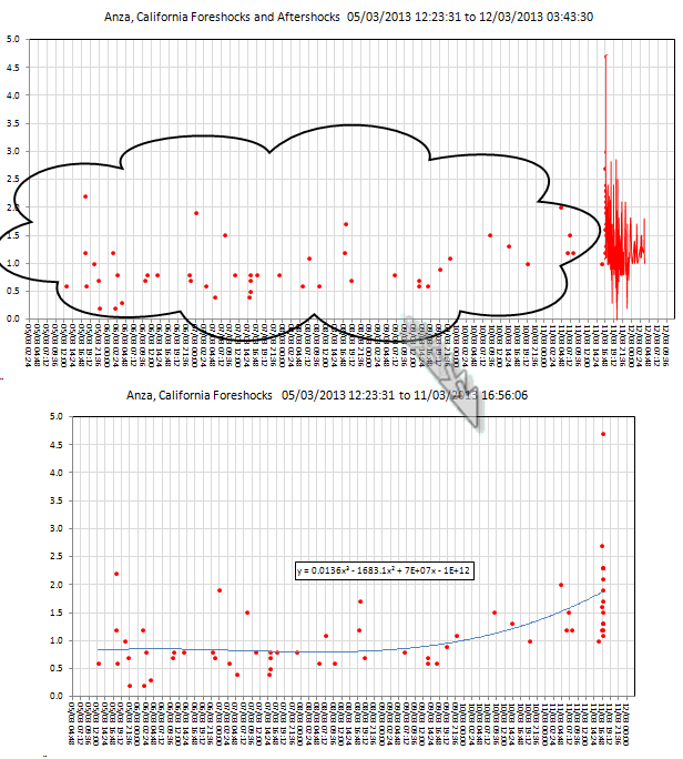
also in the 19 minutes before the 4.7 there were 15 earthquakes
When, Mag, Time before Mainshock
11/03/2013 16:56:06, 4.7, 0:00:00
11/03/2013 16:55:50, 2.3, 0:00:16
11/03/2013 16:55:43, 2.1, 0:00:23
11/03/2013 16:55:21, 1.7, 0:00:45
11/03/2013 16:54:55, 1.1, 0:01:11
11/03/2013 16:54:48, 1.2, 0:01:18
11/03/2013 16:54:20, 1.3, 0:01:46
11/03/2013 16:54:02, 1.3, 0:02:04
11/03/2013 16:51:47, 1.5, 0:04:19
11/03/2013 16:51:25, 1.9, 0:04:41
11/03/2013 16:51:09, 2.3, 0:04:57
11/03/2013 16:50:52, 2.3, 0:05:14
11/03/2013 16:39:02, 1.2, 0:17:04
11/03/2013 16:37:27, 1.6, 0:18:39
11/03/2013 16:36:12, 2.7, 0:19:54
I would say that given the previous 46 earthquakes, then an upsurge in the 20 minutes before the Main Shock of 15 quakes/20 minutes there was adequate warning.
Currently doing a project on L'Aquilla my mind is on what happened there, where there was plenty of warning.
Not so obvious to the analysts in California maybe, because not so many events to work with, but still an alert/warning could have been issued 10 minutes before.
Look at Japan, they have the technology in place and working to give 30 seconds warning across to the other side of the country of a large event occurring, enough time to prepare/brace yourself, or say if you were working on a 30ft ladder or something? time to climb down so you don't fall on your head when the quake hits. (assuming its a text alert on your mobile phone)
Of course this doesn't work everywhere, California (San Andreas in particular) is one of the few areas where there are foreshocks to Main quakes on a regular basis.
I hope someone at USGS studies all these earthquake series and can see the same thing happening. How long do they wait before alerting the public, 100 quakes? 200?
Brawley was a classic example, they waited until the Mag 5's before anything was said, luckily some folks on ATS seen the trend going on.
A Mag 6?, of course, WHEN is the big question.
edit on 13-3-2013 by muzzy because: just couldn't get a clean post!, even doing it on Notepad I didn't see I had a ? in the wrong
place!
Of course the people who find the earthquakes haven't got the time to analyze them right away, but given the billions of $ damage that a even a moderate-strong quake can cause and the deaths and injuries resulting, wouldn't it make sense to have a few people on a $50,000 a year salary sitting around keeping an eye on the incoming data? The more time spent doing it the better they would get at it. There are plenty of people out there looking for a job. Put them on something useful rather than paying them to sit at home on the dole.
Even the Insurance industry could fund it.
Geonet (NZ) is partly funded by the Earthquake Commission (which partly pays out for damage caused by earthquakes), but it doesn't go far enough IMO.
edit on 13-3-2013 by muzzy because: (no reason given)
reply to post by muzzy
latimesblogs.latimes.com...
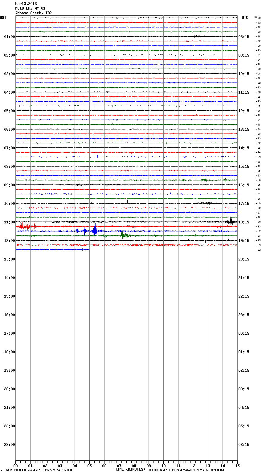
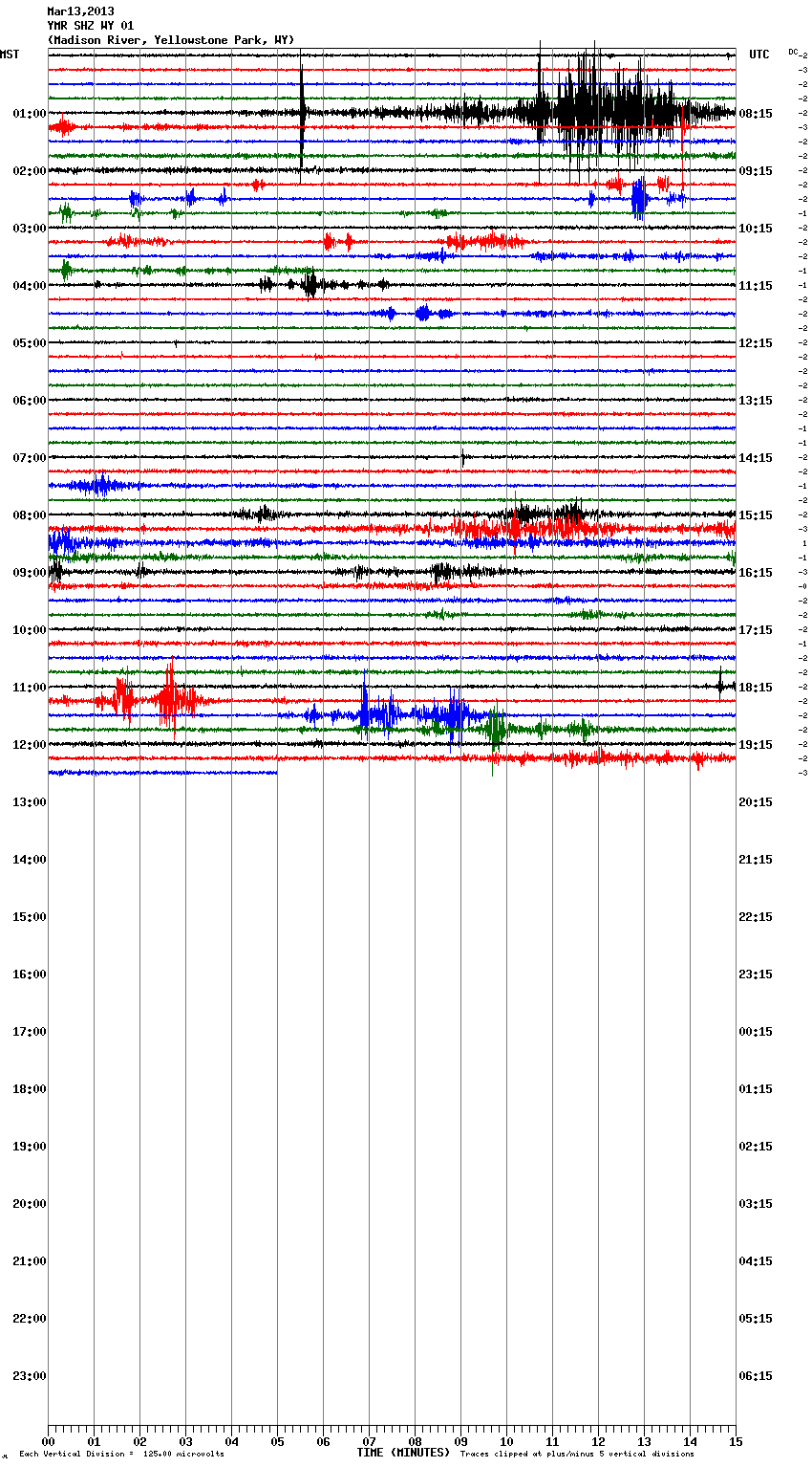
I'm going to use this post to continue a rant from a week or so ago. I'll post two shots of Yellowstone. It's not local noise, because it's widespread. Heck, maybe mining. Forget most of the noise on YMR. Whatever it was, it appears to be something near the park and moving. Hence, my paranoid view that helicopters are monitoring The park because of some changes. ???
what do i know
latimesblogs.latimes.com...
I'm going to use this post to continue a rant from a week or so ago. I'll post two shots of Yellowstone. It's not local noise, because it's widespread. Heck, maybe mining. Forget most of the noise on YMR. Whatever it was, it appears to be something near the park and moving. Hence, my paranoid view that helicopters are monitoring The park because of some changes. ???
what do i know
edit on 13-3-2013 by ericblair4891 because: (no reason given)
reply to post by muzzy
Oh, thank you so much for the in depth analysis along with the data.
I agree.... You would think they would fund such a position. There are many looking for jobs and this is something that would indeed save lives.
Thankfully we have ATS Quake Watch experts such as you and PM ...but... it would be nice if they paid you to do what you do. Its a lot of work and I know we all appreciate ALL the hard work you guys and gals do.
reply to post by MamaJ
You are welcome. I am doing a 30+ page report for work (about a leaky roof) and needed to do something else this morning before I went mental.
You are welcome. I am doing a 30+ page report for work (about a leaky roof) and needed to do something else this morning before I went mental.
reply to post by ericblair4891
some of those signals look like they have a long period between the P wave and the S wave, which means "distant", you would need to check the times against a list events of the whole planet to eliminate distant quakes.
For example that black one on the 04:00 line on the 2nd graph is probably the Eastern Siberia 5.8 and the Red one on the 08:00 would be the Alaska 5.0
There are others who write on this thread who can read those graphs better than I can though.
reply to post by muzzy
Sorry, shoud have been more specific. UTC time on the right, it starts about 18:14. Normally, I'd say it was just noise, but it shows elsewhere, and far away. And, I can't find anything on USGS to account for it. I've come to reconize most of the mining signals. These just don't fit somehow.
Sorry, shoud have been more specific. UTC time on the right, it starts about 18:14. Normally, I'd say it was just noise, but it shows elsewhere, and far away. And, I can't find anything on USGS to account for it. I've come to reconize most of the mining signals. These just don't fit somehow.
MAN.....!
Take a look at California! It looks like a war zone
earthquake.usgs.gov...
Or maybe the beginnings of one giant super volcano
Take a look at California! It looks like a war zone
earthquake.usgs.gov...
Or maybe the beginnings of one giant super volcano
reply to post by ericblair4891
Well then, if UTC is on the right, the only one that fits is the 8:15 line Alaska 5.0
Well then, if UTC is on the right, the only one that fits is the 8:15 line Alaska 5.0
reply to post by radpetey
the only ones that really count for anything on that map are;
3.4 2013/03/13 04:21:13 33.513 -116.475 11.8 19 km ( 12 mi) ESE of Anza, CA
3.0 2013/03/11 16:56:57 33.508 -116.448 14.5 21 km ( 13 mi) ESE of Anza, CA
4.7 2013/03/11 16:56:06 33.502 -116.457 13.1 21 km ( 13 mi) ESE of Anza, CA
the rest are very-minor or micro, probably not even felt by humans
MAG. DEP.
quakes.globalincidentmap.com...
Thursday March 14 2013, 09:29:09 UTC 58 minutes ago Northern California 1.2 3.6 USGS
Thursday March 14 2013, 09:24:45 UTC 63 minutes ago Northern California 1.0 0.5 USGS
Thursday March 14 2013, 09:20:42 UTC 67 minutes ago Northern California 1.0 1.6 USGS
Thursday March 14 2013, 09:20:42 UTC 67 minutes ago Northern California 1.0 1.6 USGS
Thursday March 14 2013, 09:18:31 UTC 69 minutes ago Northern California 1.7 1.8 USGS
Thursday March 14 2013, 09:17:53 UTC 69 minutes ago Northern California 1.5 0.9 USGS
Thursday March 14 2013, 09:17:23 UTC 70 minutes ago Northern California 1.4 0.7 USGS
Thursday March 14 2013, 09:16:41 UTC 71 minutes ago Northern California 1.2 4.7 USGS
Thursday March 14 2013, 09:15:59 UTC 71 minutes ago Northern California 2.2 1.1 USGS
Thursday March 14 2013, 09:14:55 UTC 72 minutes ago Northern California 1.8 0.9 USGS
Thursday March 14 2013, 09:14:14 UTC 73 minutes ago Northern California 1.2 0.9 USGS
Thursday March 14 2013, 09:12:46 UTC 75 minutes ago Northern California 2.9 0.0 USGS
Thursday March 14 2013, 09:12:28 UTC 75 minutes ago Coquimbo, Chile 2.5 67.0 CSEM-EMSC
Thursday March 14 2013, 09:12:22 UTC 75 minutes ago Northern California 1.3 0.2 USGS
Thursday March 14 2013, 09:09:23 UTC 78 minutes ago Northern California 4.6 2.0 USGS
Thursday March 14 2013, 09:09:23 UTC 78 minutes ago Offshore Northern California 4.6 12.0 CSEM-EMSC
quakes.globalincidentmap.com...
I have a question to somebody who keeps track of worldwide quakes. maybe muzzy or puterman.
Is it just my feeling, of did we see more M4+ quakes and less
Is it just my feeling, of did we see more M4+ quakes and less
Originally posted by muzzy
reply to post by radpetey
the only ones that really count for anything on that map are;
3.4 2013/03/13 04:21:13 33.513 -116.475 11.8 19 km ( 12 mi) ESE of Anza, CA
3.0 2013/03/11 16:56:57 33.508 -116.448 14.5 21 km ( 13 mi) ESE of Anza, CA
4.7 2013/03/11 16:56:06 33.502 -116.457 13.1 21 km ( 13 mi) ESE of Anza, CA
the rest are very-minor or micro, probably not even felt by humans
I am referring to the sheer number of... within the hour epicenter markings(red boxes).
That's what it looks like after a big 8er.... and over such a big area to boot!
edit on 14-3-2013 by radpetey because: (no reason given)
reply to post by radpetey
Im wondering as well, and keeping a keen eye too!
What am I missing? I can't seem to find a lot of after shocks for the one in Northern California today. Are they micro and that is why I do not see them listed? Help a girl out would ya?
Im wondering as well, and keeping a keen eye too!
What am I missing? I can't seem to find a lot of after shocks for the one in Northern California today. Are they micro and that is why I do not see them listed? Help a girl out would ya?
Originally posted by MamaJ
reply to post by radpetey
Im wondering as well, and keeping a keen eye too!
What am I missing? I can't seem to find a lot of after shocks for the one in Northern California today. Are they micro and that is why I do not see them listed? Help a girl out would ya?
I see them on USGS. You have to select all quakes for 7 days, it's default setting is 2.5 and higher.
A new area to keep are eyes on
Friday March 15 2013, 00:05:01 UTC Queen Charlotte Islands, Canada region 4.5
Friday March 15 2013, 00:05:04 UTC Queen Charlotte Islands, Canada region 4.6
Friday March 15 2013, 00:46:55 UTC Queen Charlotte Islands, Canada region 4.3
Friday March 15 2013, 00:55:44 UTC Queen Charlotte Islands, Canada region 4.4
Friday March 15 2013, 02:28:04 UTC Queen Charlotte Islands, Canada region 4.4
earthquake.usgs.gov...:eyJyZXFjb25maWciOnsiZW5hYmxlVVRDIjpmYWxzZSwiYXV0b1VwZGF0ZUludGVydmFsIjozMDAwMDAsImF1dG9VcGRhdGUiOnRyd WV9LCJmaWx0ZXIiOnsibGltaXQiOnsibGltaXQiOjEwMCwidmFsdWUiOm51bGx9LCJhZ2UiOnsibWluaW11bSI6bnVsbCwibWF4aW11bSI6NywibWluIjpudWxsLCJtYXgiOm51bGx9LCJtYWduaXR 1ZGUiOnsibWluaW11bSI6Mi41LCJtYXhpbXVtIjpudWxsLCJtaW4iOm51bGwsIm1heCI6bnVsbH0sImRlcHRoIjp7Im1pbmltdW0iOm51bGwsIm1heGltdW0iOm51bGwsIm1pbiI6bnVsbCwibWF4I jpudWxsfSwibWF4bW1pIjp7Im1pbmltdW0iOm51bGwsIm1heGltdW0iOm51bGwsIm1pbiI6bnVsbCwibWF4IjpudWxsfX0sIm1hcCI6eyJjZW50ZXIiOnsibGF0aXR1ZGUiOjM1LjM2NzA2NjUyMTQ 2OSwibG9uZ2l0dWRlIjoxNjAuNDI5NjU4OTEyMDd9LCJtYXB0eXBlIjoiU3RyZWV0IE1hcCIsInpvb20iOjAsIm92ZXJsYXlzIjpbeyJuYW1lIjoiUGxhdGVzIiwidmlzaWJsZSI6InRydWUifSx7I m5hbWUiOiJGYXVsdHMiLCJ2aXNpYmxlIjoidHJ1ZSJ9LHsibmFtZSI6Ikdsb2JhbCBIYXphcmQiLCJ2aXNpYmxlIjoiZmFsc2UifSx7Im5hbWUiOiJVUyBIYXphcmQiLCJ2aXNpYmxlIjoiZmFsc2U ifSx7Im5hbWUiOiJFYXJ0aHF1YWtlcyIsInZpc2libGUiOiJ0cnVlIn1dfSwibGlzdCI6eyJkZWZhdWx0U29ydCI6InRpbWUiLCJzb3J0QXNjZW5kaW5nIjpmYWxzZX0sImZlZWQiOiJhbGx3ZWVrI n0g
Oh o
Friday March 15 2013, 01:16:38 UTC 17 minutes ago Greater Los Angeles area, California 1.4
Friday March 15 2013, 01:16:00 UTC 18 minutes ago Greater Los Angeles area, California 1.3
Friday March 15 2013, 01:13:07 UTC 21 minutes ago Greater Los Angeles area, California 2.2
Friday March 15 2013, 01:32:09 UTC 118 seconds ago Greater Los Angeles area California 1.5
Friday March 15 2013, 00:05:01 UTC Queen Charlotte Islands, Canada region 4.5
Friday March 15 2013, 00:05:04 UTC Queen Charlotte Islands, Canada region 4.6
Friday March 15 2013, 00:46:55 UTC Queen Charlotte Islands, Canada region 4.3
Friday March 15 2013, 00:55:44 UTC Queen Charlotte Islands, Canada region 4.4
Friday March 15 2013, 02:28:04 UTC Queen Charlotte Islands, Canada region 4.4
earthquake.usgs.gov...:eyJyZXFjb25maWciOnsiZW5hYmxlVVRDIjpmYWxzZSwiYXV0b1VwZGF0ZUludGVydmFsIjozMDAwMDAsImF1dG9VcGRhdGUiOnRyd WV9LCJmaWx0ZXIiOnsibGltaXQiOnsibGltaXQiOjEwMCwidmFsdWUiOm51bGx9LCJhZ2UiOnsibWluaW11bSI6bnVsbCwibWF4aW11bSI6NywibWluIjpudWxsLCJtYXgiOm51bGx9LCJtYWduaXR 1ZGUiOnsibWluaW11bSI6Mi41LCJtYXhpbXVtIjpudWxsLCJtaW4iOm51bGwsIm1heCI6bnVsbH0sImRlcHRoIjp7Im1pbmltdW0iOm51bGwsIm1heGltdW0iOm51bGwsIm1pbiI6bnVsbCwibWF4I jpudWxsfSwibWF4bW1pIjp7Im1pbmltdW0iOm51bGwsIm1heGltdW0iOm51bGwsIm1pbiI6bnVsbCwibWF4IjpudWxsfX0sIm1hcCI6eyJjZW50ZXIiOnsibGF0aXR1ZGUiOjM1LjM2NzA2NjUyMTQ 2OSwibG9uZ2l0dWRlIjoxNjAuNDI5NjU4OTEyMDd9LCJtYXB0eXBlIjoiU3RyZWV0IE1hcCIsInpvb20iOjAsIm92ZXJsYXlzIjpbeyJuYW1lIjoiUGxhdGVzIiwidmlzaWJsZSI6InRydWUifSx7I m5hbWUiOiJGYXVsdHMiLCJ2aXNpYmxlIjoidHJ1ZSJ9LHsibmFtZSI6Ikdsb2JhbCBIYXphcmQiLCJ2aXNpYmxlIjoiZmFsc2UifSx7Im5hbWUiOiJVUyBIYXphcmQiLCJ2aXNpYmxlIjoiZmFsc2U ifSx7Im5hbWUiOiJFYXJ0aHF1YWtlcyIsInZpc2libGUiOiJ0cnVlIn1dfSwibGlzdCI6eyJkZWZhdWx0U29ydCI6InRpbWUiLCJzb3J0QXNjZW5kaW5nIjpmYWxzZX0sImZlZWQiOiJhbGx3ZWVrI n0g
edit on 7/30/2012 by dreamfox1 because: quakes.globalincidentmap.com...
edit on 7/30/2012 by dreamfox1 because: Just
love how big the usgs site address is lol
Oh o
Friday March 15 2013, 01:16:38 UTC 17 minutes ago Greater Los Angeles area, California 1.4
Friday March 15 2013, 01:16:00 UTC 18 minutes ago Greater Los Angeles area, California 1.3
Friday March 15 2013, 01:13:07 UTC 21 minutes ago Greater Los Angeles area, California 2.2
Friday March 15 2013, 01:32:09 UTC 118 seconds ago Greater Los Angeles area California 1.5
edit on 7/30/2012 by dreamfox1
because: (no reason given)
Now this thread came up
Report predicts massive death, destruction from overdue Pacific Northwest mega-quake
Posted by goou111
"A report published by the Oregon Seismic Safety Policy Advisory Commission,said More than 10,000 people could die when — not if — a monster earthquake and tsunami occur just off the Pacific Northwest coast
They told Oregon legislators after the Legislature authorized the study of what would happen if a quake and tsunami such as the one that devastated Japan hit the Pacific Northwest
Oregon legislators requested the study so they could better inform themselves about what needs to be done to prepare and recover from such a giant natural disaster
The report says that geologically, Oregon and Japan are mirror images but Japan was way more prepared for such an event because it had spent billions on technology to reduce the damage "
www.abovetopsecret.com...
edit on 7/30/2012 by dreamfox1 because:
www.staradvertiser.com...
edit on 7/30/2012 by dreamfox1 because: www.abovetopsecret.com...
edit on 7/30/2012 by
dreamfox1 because: www.pnsn.org...
Not surprised USGS haven't got this one,
but am surprised LDEO haven't caught it, they are usually good with open ocean quakes
just NE of the middle of nowhere (French Polynesia)
EMSC are being unkind not to list Papeete pop 26,017 (August 2007 census)
The urban area of Papeete had a total population of 131,695 inhabitants at the August 2007 census [wiki]
location on Gmaps
but am surprised LDEO haven't caught it, they are usually good with open ocean quakes
just NE of the middle of nowhere (French Polynesia)
EMSC are being unkind not to list Papeete pop 26,017 (August 2007 census)
The urban area of Papeete had a total population of 131,695 inhabitants at the August 2007 census [wiki]
Magnitude mb 5.2
Region SOUTH PACIFIC OCEAN
Date time 2013-03-13 03:07:03.0 UTC
Location 8.71 S ; 132.32 W
Depth 10 km
Distances 4550 km SW Guadalajara (pop 1,640,589 ; local time 21:07:03.9 2013-03-12)
4346 km SE Honolulu (pop 384,241 ; local time 17:07:03.9 2013-03-12)
2095 km NE Mahina (pop 14,224 ; local time 17:07:03.9 2013-03-12)
www.emsc-csem.org...
location on Gmaps
edit on 15-3-2013 by muzzy because: (no reason given)
new topics
-
Pentagon acknowledges secret UFO project, the Kona Blue program | Vargas Reports
Aliens and UFOs: 56 minutes ago -
Boston Dynamics say Farewell to Atlas
Science & Technology: 1 hours ago -
I hate dreaming
Rant: 1 hours ago -
Is the origin for the Eye of Horus the pineal gland?
Philosophy and Metaphysics: 3 hours ago -
Man sets himself on fire outside Donald Trump trial
Mainstream News: 3 hours ago -
Biden says little kids flip him the bird all the time.
2024 Elections: 3 hours ago -
The Democrats Take Control the House - Look what happened while you were sleeping
US Political Madness: 4 hours ago -
Sheetz facing racial discrimination lawsuit for considering criminal history in hiring
Social Issues and Civil Unrest: 4 hours ago -
In an Historic First, In N Out Burger Permanently Closes a Location
Mainstream News: 6 hours ago -
MH370 Again....
Disaster Conspiracies: 6 hours ago
top topics
-
In an Historic First, In N Out Burger Permanently Closes a Location
Mainstream News: 6 hours ago, 14 flags -
The Democrats Take Control the House - Look what happened while you were sleeping
US Political Madness: 4 hours ago, 10 flags -
Thousands Of Young Ukrainian Men Trying To Flee The Country To Avoid Conscription And The War
Other Current Events: 17 hours ago, 8 flags -
A man of the people
Medical Issues & Conspiracies: 11 hours ago, 8 flags -
Man sets himself on fire outside Donald Trump trial
Mainstream News: 3 hours ago, 7 flags -
Biden says little kids flip him the bird all the time.
2024 Elections: 3 hours ago, 6 flags -
4 plans of US elites to defeat Russia
New World Order: 13 hours ago, 4 flags -
Is the origin for the Eye of Horus the pineal gland?
Philosophy and Metaphysics: 3 hours ago, 4 flags -
Sheetz facing racial discrimination lawsuit for considering criminal history in hiring
Social Issues and Civil Unrest: 4 hours ago, 3 flags -
Are you ready for the return of Jesus Christ? Have you been cleansed by His blood?
Religion, Faith, And Theology: 9 hours ago, 3 flags
active topics
-
12 jurors selected in Trump criminal trial
US Political Madness • 107 • : Xtrozero -
Man sets himself on fire outside Donald Trump trial
Mainstream News • 30 • : HatesFreshAir -
The Democrats Take Control the House - Look what happened while you were sleeping
US Political Madness • 36 • : DBCowboy -
The defamation of Mary Magdalene
Religion, Faith, And Theology • 14 • : DISRAELI2 -
Mood Music Part VI
Music • 3063 • : lilzazz -
Russian intelligence officer: explosions at defense factories in the USA and Wales may be sabotage
Weaponry • 176 • : BernnieJGato -
-@TH3WH17ERABB17- -Q- ---TIME TO SHOW THE WORLD--- -Part- --44--
Dissecting Disinformation • 543 • : SideEyeEverything1 -
Elites disapearing
Political Conspiracies • 33 • : 0bserver1 -
Fossils in Greece Suggest Human Ancestors Evolved in Europe, Not Africa
Origins and Creationism • 78 • : strongfp -
Pentagon acknowledges secret UFO project, the Kona Blue program | Vargas Reports
Aliens and UFOs • 2 • : Macenroe1982