It looks like you're using an Ad Blocker.
Please white-list or disable AboveTopSecret.com in your ad-blocking tool.
Thank you.
Some features of ATS will be disabled while you continue to use an ad-blocker.

Quake Watch 2013
page: 51share:
Nikko Nat Park Honshu still going off after that 6.2 on 25/02/2013, mostly micros or very minor size now
Geophysical report of this last week now done except volcanoes -
run out of time and have to go out.
New section this week onwards tracking Solar Flux Units and the AP Index, nTeslas and other stuff - some still to be added.
ETA: Looks like I forgot to change my signature to reflect the report for the week ending 22 Feb so apologies for that and here is a link to it
New section this week onwards tracking Solar Flux Units and the AP Index, nTeslas and other stuff - some still to be added.
ETA: Looks like I forgot to change my signature to reflect the report for the week ending 22 Feb so apologies for that and here is a link to it
edit on 3/3/2013 by PuterMan because: (no reason given)
earthquake.usgs.gov/earthquakes/eqarchives/fm/neic_c000fff5_fmt.php
geofon.gfz-potsdam.de/data/alerts/2013/gfz2013ehwy/mt.txt
30 injured in southwest China quake
English.news.cn 2013-03-04 00:18:00
news.xinhuanet.com/english/china/2013-03/04/c_132205114.htm
USGS Body-Wave Moment Tensor Solution
YUNNAN, CHINA
13/03/03 05:41:20.10
Epicenter: 25.968 99.815
MW 5.2
USGS MOMENT TENSOR SOLUTION
Depth 8 No. of sta: 19
geofon.gfz-potsdam.de/data/alerts/2013/gfz2013ehwy/mt.txt
GFZ Event gfz2013ehwy
13/03/03 05:41:19.33
Yunnan, China
Epicenter: 25.94 99.67
MW 5.4
GFZ MOMENT TENSOR SOLUTION
Depth 15 No. of sta: 54
30 injured in southwest China quake
English.news.cn 2013-03-04 00:18:00
news.xinhuanet.com/english/china/2013-03/04/c_132205114.htm
KUNMING, March 3 (Xinhua) -- Thirty people have been confirmed injured, including three seriously, after a 5.5-magnitude earthquake hit southwest China's Yunnan Province on Sunday afternoon.
Some 12,000 people have also been evacuated, said the provincial Civil Affairs Department.
The quake hit Eryuan County, Dali Bai Autonomous Prefecture at 1:41 p.m.. The epicenter was in Xishan Township with a depth of 9 km.
Latest statistics showed 92,000 residents were affected by the quake, while 83,434 houses were damaged and 1,781 others collapsed. Infrastructure including schools, transportation and communications systems, water and power lines was damaged to various degrees.
The Yunnan provincial government initiated a grade-III emergency response earlier and later upgraded it to grade-II.
The Civil Affairs Department said 3,000 tents, 7,000 cotton quilts and 7,000 coats were being sent to the quake-hit area.
A quake relief team consisting of more than 400 policemen, fire fighters and soldiers has been dispatched.
Some 34 aftershocks have been recorded after the quake.
In history, 19 earthquakes of magnitude 5 or above occurred within a 50-km radius of the epicenter.
Editor: yan
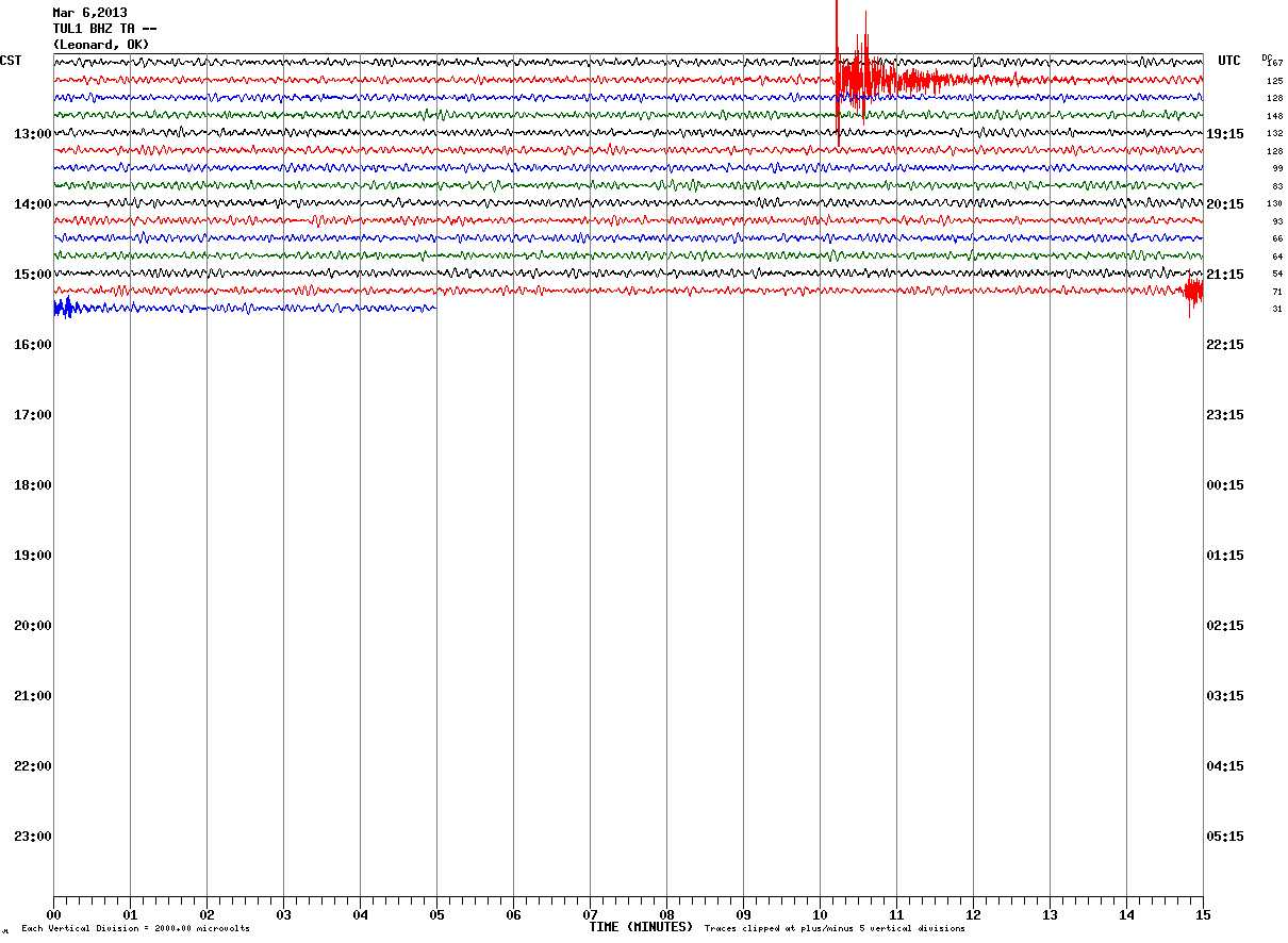
The newest Oklahoma earthquake is a frackquake.
It is in a new area to the south, much removed from the other "swarm zone" near Oklahoma City.
The area to the south of the epicenter is littered with frack pads and it looks like there's a refinery/natural gas storage facility in the neighbourhood as well.
I wonder if they are storing the Liquid Natural Gas LNG underground in some sort of salt dome like they had in Lousiana which produced that monster sinkhole. If so, they are doing so by a resovoir and lake. Brilliant. maybe
frack 'em
Why can't I learn not to take a second look. There's a nice wild refuge near those gas fields. I'm sure the water is fine and there's no need to worry about them polluting the water. In Hamilton, Ontario, Canada, there's a habour where there's a dead zone. As well, there's one in the Gulf of Mexico. And so on...
edit on 4-3-2013 by ericblair4891 because: (no reason given)
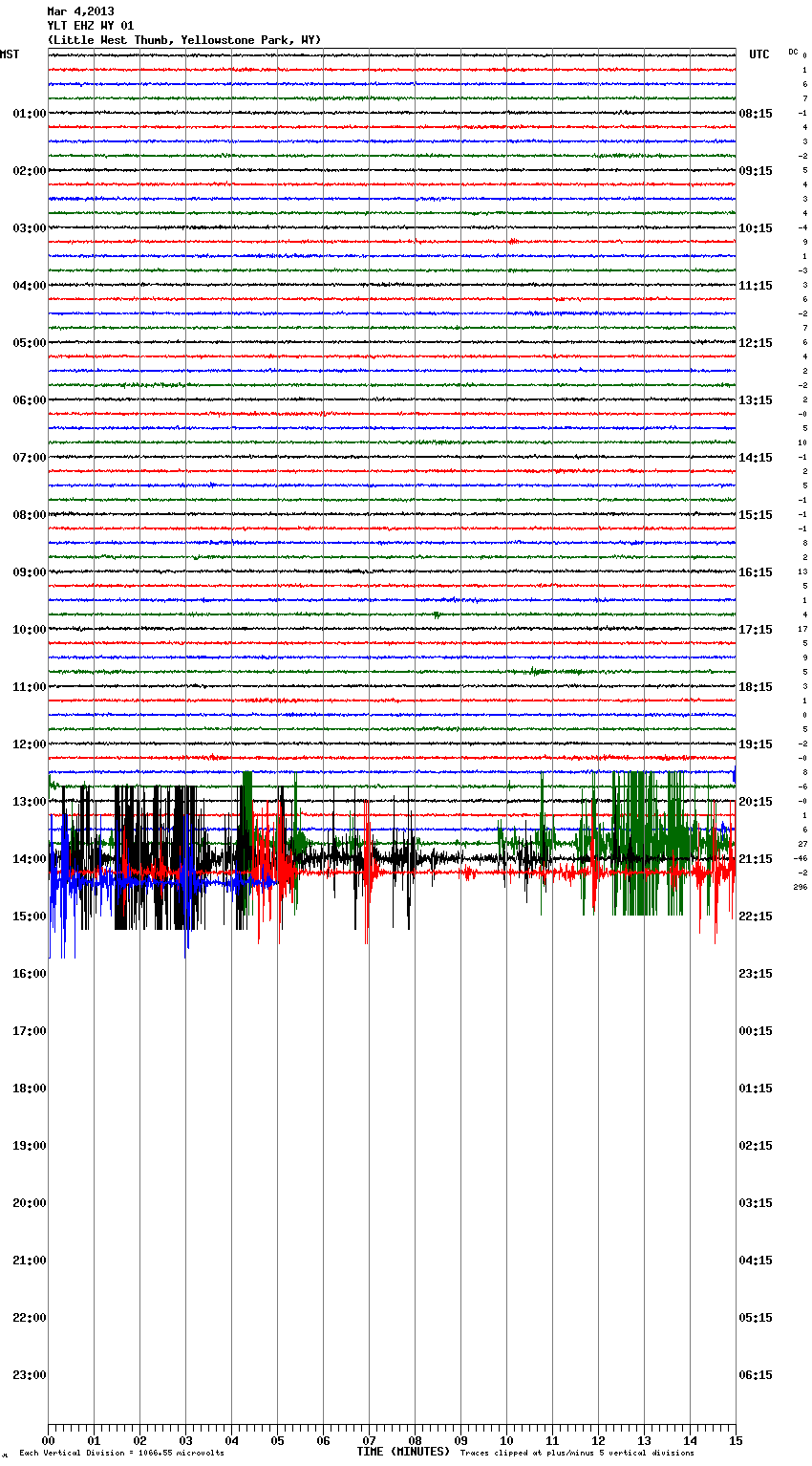
whatever it is, (it's siesmic on one sort or another because it shows on multiple stations- my guess hydrothermal since it appears to be under the lake) it seems to be continuing as i watch gee
i had been watching due to tiny quakes near Madison Plateau
edit on 4-3-2013 by ericblair4891 because: (no reason given)
edit
on 4-3-2013 by ericblair4891 because: (no reason given)
seems to have quieted now.
edit on 4-3-2013 by ericblair4891 because: (no reason given)
reply to post by ericblair4891
Those are 3 quakes West-North/West from Lake Yellow Stone.
earthquake.usgs.gov...
earthquake.usgs.gov...
earthquake.usgs.gov...
Those are 3 quakes West-North/West from Lake Yellow Stone.
earthquake.usgs.gov...
earthquake.usgs.gov...
earthquake.usgs.gov...
Originally posted by wujotvowujotvowujotvo
news.xinhuanet.com/english/china/2013-03/04/c_132205114.htm
KUNMING, March 3 (Xinhua) -- Thirty people have been confirmed injured, including three seriously
83,434 houses were damaged and 1,781 others collapsed.
In history, 19 earthquakes of magnitude 5 or above occurred within a 50-km radius of the epicenter.
Editor: yan
8-15km, shallow, quite a strong quake given the damage.
We do tend to get too casual about those mid to high 5's when so many of them are offshore and don't cause any damage.
also details from CENC
1970-2012 mag5+ map
Some 34 aftershocks have been recorded after the quake.
I hate it when the MSM say that, but don't link to the source, so where is the data?
It takes a bit of finding (actually bothering to look for it)
China Earthquake Networks earthquake catalog (1 week) (translated to English) [color=lime]* muzzy's find of the week
They do get quite a few quakes, 774 (mostly micro [less than mag2] or very-minor [mag2-3]on this interactive map I created from that data (centered on Eryuan County, Dali Bai Autonomous Prefecture, Yunnan, the epicenter in question) (zoom out for the whole country)
goo.gl...
edit on 5-3-2013 by muzzy because: I feel a new page on Earthquake Archives coming on
edit on 5-3-2013 by muzzy because:
changed the GMaps link, had UTC when it was local time, and had a bracket wrong in the html so the time didn't show on the popup tag text
anyway
found the search page (one of them) here
starts on 2009-01-02 @ 10:43:33.4, mag 0.1+
there are a couple of other catalog's linked on that page, one has mag 3+ data from January 1, 1970 to 2012, a total of 147,633 events
edit on 5-3-2013 by muzzy because: (no reason given)
www.okgeosurvey1.gov...
This the site for Oklahoma. All the recent activity has broke there network. Or, are they hiding something. I've tried to get good graphs and find good stations, but even Puterman gave up. So, just assume the activity is constant. Never ending. Soon to growing again as they reconfigure the sub-surface which took eons to form. I'm sure their tinkering with it will come to much good for all. mutter mutter rabble rabble
Well, I might not be able to look at Oklahoma, but I can look at Yellowstone.
0.9 2013/03/05 00:15:02 44.091N 110.449W 4.3 58 km (36 mi) NE of Alta, WY
2.2 2013/03/04 14:01:24 44.477N 110.570W 2.9 47 km (29 mi) ESE of West Yellowstone, MT
2.6 2013/03/04 13:57:42 44.472N 110.564W 3.8 48 km (30 mi) ESE of West Yellowstone, MT
1.4 2013/03/04 13:57:37 44.472N 110.562W 4.8 48 km (30 mi) ESE of West Yellowstone, MT
1.5 2013/03/04 13:57:14 44.469N 110.572W 5.1 47 km (29 mi) ESE of West Yellowstone, MT
0.2 2013/03/04 13:56:49 44.477N 110.571W 6.9 47 km (29 mi) ESE of West Yellowstone, MT
1.8 2013/03/04 13:49:18 44.426N 110.444W 2.8 59 km (36 mi) ESE of West Yellowstone, MT
1.4 2013/03/04 13:49:10 44.479N 110.576W 2.4 47 km (29 mi) ESE of West Yellowstone, MT
0.7 2013/03/04 12:44:51 44.286N 110.463W 9.9 66 km (41 mi) SE of West Yellowstone, MT
0.3 2013/03/04 12:02:37 44.727N 111.022W 1.3 10 km ( 6 mi) NE of West Yellowstone, MT
1.0 2013/03/04 10:01:47 44.719N 111.035W 7.2 8 km ( 5 mi) NE of West Yellowstone, MT
0.8 2013/03/04 08:58:46 44.719N 111.024W 7.3 9 km ( 6 mi) NE of West Yellowstone, MT
0.9 2013/03/04 08:27:46 44.714N 111.024W 7.3 9 km ( 5 mi) NE of West Yellowstone, MT
0.6 2013/03/03 19:23:18 44.707N 111.032W 7.0 8 km ( 5 mi) NE of West Yellowstone, MT
0.8 2013/03/03 01:35:07 44.678N 110.454W 3.2 45 km (28 mi) SSE of Gardiner, MT
1.3 2013/03/02 05:35:35 44.448N 110.614W 5.2 46 km (28 mi) ESE of West Yellowstone, MT
1.1 2013/03/02 03:31:58 44.519N 110.914W 5.9 22 km (14 mi) SE of West Yellowstone, MT
0.9 2013/03/01 23:51:59 44.522N 110.918W 3.0 22 km (13 mi) SE of West Yellowstone, MT
1.1 2013/03/01 23:50:56 44.521N 110.917W 5.6 22 km (13 mi) SE of West Yellowstone, MT
0.6 2013/03/01 11:49:21 44.771N 110.962W 7.3 17 km (10 mi) NE of West Yellowstone, MT
0.7 2013/03/01 06:16:47 44.236N 110.847W 3.7 40 km (25 mi) ENE of Warm River, ID
1.4 2013/03/01 00:15:51 44.243N 110.788W 4.8 45 km (28 mi) ENE of Warm River, ID
1.5 2013/03/01 00:15:50 44.228N 110.770W 3.8 45 km (28 mi) ENE of Warm River, ID
1.2 2013/02/27 09:50:18 44.724N 111.160W 12.3 8 km ( 5 mi) NNW of West Yellowstone, MT
0.9 2013/02/26 21:24:44 44.612N 111.141W 8.4 6 km ( 4 mi) SSW of West Yellowstone, MT
my guess is still hydro-thermal
edit on 5-3-2013 by ericblair4891 because: (no reason given)
Hmm what about this M5.0+ ones near Papua New Guinea? How do you guys think it will develop? Somehow similar to Santa Cruz or not? I mean before the
big one
edit on 6-3-2013 by aLLeKs because: (no reason given)
It won't be long before another big quake hits. Who knows where this time. Their growing in frequency and in strength. I know where I live they're
not real common, but there has been an increase in recent weeks.
So.... Prince Edward Islands seems to be doing a little swarm dance.
earthquake.usgs.gov...
MAP 4.3 2013/03/06 07:30:48 -43.309 40.072 10.0 PRINCE EDWARD ISLANDS REGION
MAP 5.0 2013/03/06 12:28:15 -43.381 39.690 10.0 PRINCE EDWARD ISLANDS REGION
MAP 4.9 2013/03/06 12:24:33 -43.387 39.564 10.0 PRINCE EDWARD ISLANDS REGION
MAP 5.2 2013/03/06 10:30:54 -43.483 39.961 9.4 PRINCE EDWARD ISLANDS REGION
MAP 4.6 2013/03/06 08:57:44 -43.361 40.187 10.0 PRINCE EDWARD ISLANDS REGION
MAP 4.5 2013/03/06 08:19:19 -43.407 39.979 14.8 PRINCE EDWARD ISLANDS REGION
earthquake.usgs.gov...
like I posted before, we will start seeing a bit more activity arround the world
NZ Update, 3 hot spots ( data from last 7 days )
a band across Central North Island
East to West;
North Madden Bank, South of Cape Kidnappers/ Ocean Beach
Elsthorpe/Waipukurau
South Taranaki Bight SW of Wanganui
interactive map
nothing major, bit of subduction going on.
a band across Central North Island
East to West;
North Madden Bank, South of Cape Kidnappers/ Ocean Beach
Elsthorpe/Waipukurau
South Taranaki Bight SW of Wanganui
interactive map
nothing major, bit of subduction going on.
reply to post by MamaJ
LDEO has more;
www.ldeo.columbia.edu...
LDEO has more;
2013 3 6 12 28 16.0 -43.25 39.75 33.0 5.2 PRINCE EDWARD ISLANDS REGION
2013 3 6 12 24 24.0 -43.25 39.75 33.0 5.1 PRINCE EDWARD ISLANDS REGION
2013 3 6 10 30 48.0 -43.25 40.25 33.0 5.6 PRINCE EDWARD ISLANDS REGION
2013 3 6 8 57 44.0 -43.25 40.25 33.0 5.3 PRINCE EDWARD ISLANDS REGION
2013 3 6 8 47 4.0 -43.25 40.25 33.0 5.3 PRINCE EDWARD ISLANDS REGION
2013 3 6 8 19 12.0 -43.25 40.25 33.0 [color=9E7BFF]4.9 PRINCE EDWARD ISLANDS REGION
2013 3 6 7 56 32.0 -43.25 40.25 33.0 5.1 PRINCE EDWARD ISLANDS REGION
2013 3 6 7 30 40.0 -43.25 40.25 33.0 5.0 PRINCE EDWARD ISLANDS REGION
2013 3 6 4 47 44.0 -43.25 40.25 33.0 5.2 PRINCE EDWARD ISLANDS REGION
www.ldeo.columbia.edu...
edit on 6-3-2013 by muzzy because: add some colour, Note* these
mags are Ms
reply to post by sc1981
Are you sure about that?
If you take away aftershocks (particularily Santa Cruz) I'd say activity is down for 2013 so far, or "normal"
Are you sure about that?
If you take away aftershocks (particularily Santa Cruz) I'd say activity is down for 2013 so far, or "normal"
reply to post by aLLeKs
I must have missed your post before. Why do you suppose more activity will come into play across the world???
I must have missed your post before. Why do you suppose more activity will come into play across the world???
I'm always paranoid. In the words of the Great Johnny Fever, "When everybody is out to get you, paranoia is just good thinking."
Could some one check the Okie site to see if it works. Or, is it just me?
www.okgeosurvey1.gov...
There's been another sizeable one I believe. Although, it's not listed yet. I'll say 3m. Why not.
It's hard to catch all them though. The smaller ones aren't always picked up by public stations.
Hehehehehe. They just listed it when I checked back.
earthquake.usgs.gov...
Frackquake. Google earth shows the gasboys figerprints all over the epicenter.
Natural!?
My frackin ass.
There seems to be another smaller on following along.
May not get listed due to it's size. It's so damned hard to tell.
edit on 6-3-2013 by ericblair4891 because: (no reason given)
edit on 6-3-2013 by ericblair4891 because: (no reason
given)
Originally posted by MamaJ
reply to post by aLLeKs
I must have missed your post before. Why do you suppose more activity will come into play across the world???
no it was just pretty quiet for 1 or 2 days, so I was not suprised to see so many (or normal activity level now) of M5.0+ quakes. I just said we will start seeing a bit more.
It will slow down again, it is just a regular up and down somehow.
new topics
-
Weinstein's conviction overturned
Mainstream News: 38 minutes ago -
Supreme Court Oral Arguments 4.25.2024 - Are PRESIDENTS IMMUNE From Later Being Prosecuted.
Above Politics: 2 hours ago -
Krystalnacht on today's most elite Universities?
Social Issues and Civil Unrest: 2 hours ago -
Chris Christie Wishes Death Upon Trump and Ramaswamy
Politicians & People: 2 hours ago -
University of Texas Instantly Shuts Down Anti Israel Protests
Education and Media: 4 hours ago -
Any one suspicious of fever promotions events, major investor Goldman Sachs card only.
The Gray Area: 7 hours ago -
God's Righteousness is Greater than Our Wrath
Religion, Faith, And Theology: 11 hours ago
top topics
-
VP's Secret Service agent brawls with other agents at Andrews
Mainstream News: 15 hours ago, 11 flags -
Nearly 70% Of Americans Want Talks To End War In Ukraine
Political Issues: 16 hours ago, 6 flags -
Krystalnacht on today's most elite Universities?
Social Issues and Civil Unrest: 2 hours ago, 6 flags -
Sunak spinning the sickness figures
Other Current Events: 16 hours ago, 5 flags -
Supreme Court Oral Arguments 4.25.2024 - Are PRESIDENTS IMMUNE From Later Being Prosecuted.
Above Politics: 2 hours ago, 5 flags -
Weinstein's conviction overturned
Mainstream News: 38 minutes ago, 4 flags -
Electrical tricks for saving money
Education and Media: 14 hours ago, 4 flags -
University of Texas Instantly Shuts Down Anti Israel Protests
Education and Media: 4 hours ago, 2 flags -
Any one suspicious of fever promotions events, major investor Goldman Sachs card only.
The Gray Area: 7 hours ago, 2 flags -
Chris Christie Wishes Death Upon Trump and Ramaswamy
Politicians & People: 2 hours ago, 1 flags
active topics
-
Supreme Court Oral Arguments 4.25.2024 - Are PRESIDENTS IMMUNE From Later Being Prosecuted.
Above Politics • 19 • : namehere -
Weinstein's conviction overturned
Mainstream News • 8 • : hangedman13 -
-@TH3WH17ERABB17- -Q- ---TIME TO SHOW THE WORLD--- -Part- --44--
Dissecting Disinformation • 670 • : cherokeetroy -
Nearly 70% Of Americans Want Talks To End War In Ukraine
Political Issues • 78 • : Consvoli -
University of Texas Instantly Shuts Down Anti Israel Protests
Education and Media • 100 • : CriticalStinker -
British TV Presenter Refuses To Use Guest's Preferred Pronouns
Education and Media • 159 • : 5thHead -
HORRIBLE !! Russian Soldier Drinking Own Urine To Survive In Battle
World War Three • 40 • : Myhandle -
President BIDEN Vows to Make Americans Pay More Federal Taxes in 2025 - Political Suicide.
2024 Elections • 144 • : underpass61 -
Sunak spinning the sickness figures
Other Current Events • 19 • : Freeborn -
Candidate TRUMP Now Has Crazy Judge JUAN MERCHAN After Him - The Stormy Daniels Hush-Money Case.
Political Conspiracies • 746 • : matafuchs