It looks like you're using an Ad Blocker.
Please white-list or disable AboveTopSecret.com in your ad-blocking tool.
Thank you.
Some features of ATS will be disabled while you continue to use an ad-blocker.

Quake Watch 2013
page: 31share:
The new layout now uses Flinn-Engdahl regions...after the 8/7.9 earthquake, it changed.
earthquake.usgs.gov/earthquakes/map/
EMSC-CSEM is the first to downgrade to 7.9 Mw.
GFZ still have their preliminary tensor issued at night with 37 stations.
Columbia LDEO GCMT so far only issued a tensor for the immediate previous foreshock of Mw 6 at 00:07 GMT/UTC
USGS tensors - WPhase 8 Mw, 112 stations ; Centroid 7.9 Mw, 202 stations
earthquake.usgs.gov/earthquakes/map/
8.0 SANTA CRUZ ISLANDS 2013-02-06 01:12:27 10.738°S 165.138°E 28.7
5.3 89km W of Lata, Solomon Islands 2013-02-06 00:46:01 10.871°S 165.029°E 9.5
EMSC-CSEM is the first to downgrade to 7.9 Mw.
GFZ still have their preliminary tensor issued at night with 37 stations.
Columbia LDEO GCMT so far only issued a tensor for the immediate previous foreshock of Mw 6 at 00:07 GMT/UTC
USGS tensors - WPhase 8 Mw, 112 stations ; Centroid 7.9 Mw, 202 stations
edit on 6-2-2013 by wujotvowujotvowujotvo because: (no reason
given)
reply to post by PuterMan
What I was referring to (not sure about Olivine) is the fact both (blogger and MariaLida) said the Santa Cruz EQ's were foreshocks and both expected "bigger one". The bigger one came. MariaLida said to expect bigger one because dangerous time for the area.
Not sure how either knew, maybe it was just instinct??
reply to post by muzzy
Did you take into account that my list includes some precursor quakes from as far back as January?
Thats interesting USGS have 20 more quakes than Geofon, are they making them up now?
Did you take into account that my list includes some precursor quakes from as far back as January?
Columbia/LDEO/GCMT Centroid Moment Tensor - 7.9 Mw / 8.0 Ms
www.emsc-csem.org/Earthquake/mtfull.php?id=303577
www.globalcmt.org/cgi-bin/globalcmt-cgi-bin/CMT4/form?itype=ymd&yr=2013&mo=2&day=6&oyr=1976&omo=1&oday=1&jyr=1976&jday=1&ojyr=1976&ojday=1&otype= nd&nday=1&lmw=0&umw=10&lms=0&ums=10&lmb=0&umb=10&llat=-90&ulat=90&llon=-180&ulon=180&lhd=0&uhd=1000<s=-9999&uts=9999&lpe1=0&upe1=90&lpe2=0&upe2=90&l ist=0
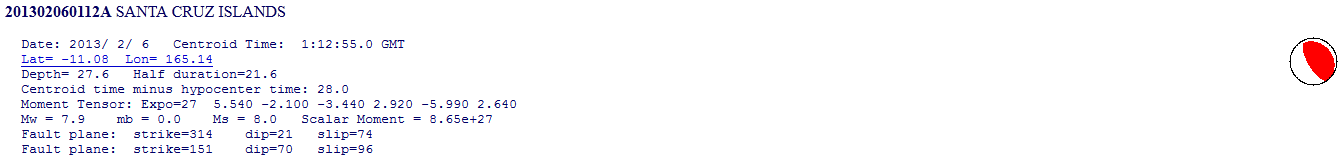
201302060112A SANTA CRUZ ISLANDS
Date: 2013/ 2/ 6 Centroid Time: 1:12:55.0 GMT
Lat= -11.08 Lon= 165.14
Depth= 27.6 Half duration=21.6
Centroid time minus hypocenter time: 28.0
Moment Tensor: Expo=27 5.540 -2.100 -3.440 2.920 -5.990 2.640
Mw = 7.9 mb = 0.0 Ms = 8.0 Scalar Moment = 8.65e+27
Fault plane: strike=314 dip=21 slip=74
Fault plane: strike=151 dip=70 slip=96
This area is complex...
Normally, we think of the Pacific plate doing the subducting--diving under continental crust, but not in this area.
According to the USGS Summary page of the Santa Cruz mag 8.0, the Australian plate is subducting under the Pacific plate in this location.
I marked up the USGS real-time map (zoomed into the region) to help me understand this, using information from the summary page.
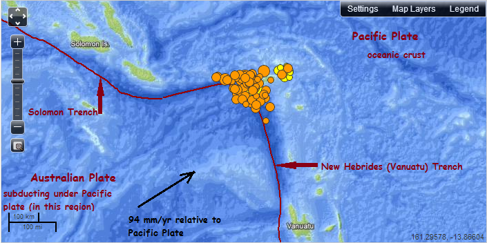
So, is this a case of oceanic crust subducting under oceanic crust?
I guess because Australia is a continent, I thought the Pacific would be the subducting plate. And it is, further to the east, at the Tonga/Kermadec Trench.
You can check out the slab-depth models for each of these trenches here.
Normally, we think of the Pacific plate doing the subducting--diving under continental crust, but not in this area.
According to the USGS Summary page of the Santa Cruz mag 8.0, the Australian plate is subducting under the Pacific plate in this location.
I marked up the USGS real-time map (zoomed into the region) to help me understand this, using information from the summary page.
So, is this a case of oceanic crust subducting under oceanic crust?
I guess because Australia is a continent, I thought the Pacific would be the subducting plate. And it is, further to the east, at the Tonga/Kermadec Trench.
You can check out the slab-depth models for each of these trenches here.
reply to post by Olivine
The slab model shows, as I suspected, that it finishes as it meets the bend.
I still think that all of this is a rip and not subduction as they are all shallow. The Pacific plate was twisted during the Japan quake and this is the lower part springing away on that bend tearing the corner as it goes. But I am probably wrong.
reply to post by wujotvowujotvowujotvo
Naming convention reversed to the new format. Flinn-Engdahl regions lasted some 12 hours...
The new layout now uses Flinn-Engdahl regions
Naming convention reversed to the new format. Flinn-Engdahl regions lasted some 12 hours...
is there a facebook group or page that is similar to the activity on this thread? i tried to search but came up with nothing. anyone know?
i'm guessing there's not but i wish there was.
here is that map I was working on last night
[color=lime](click image for interactive map, opens in new tab/window)
The Foreshocks and Aftershocks are split into two separate files so you can click either one on or off.
I gave the GFZ's 7.9 a blue icon as it probably was 8.0Ms
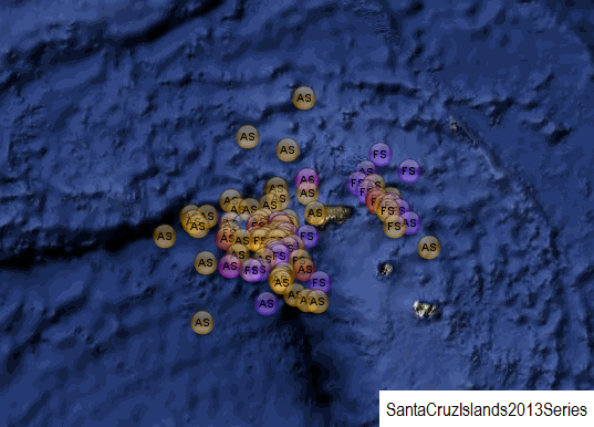
[color=lime](click image for interactive map, opens in new tab/window)
The Foreshocks and Aftershocks are split into two separate files so you can click either one on or off.
I gave the GFZ's 7.9 a blue icon as it probably was 8.0Ms
reply to post by PuterMan
I think your ripping idea is quite possible, Puterman. Check out the notes to the Broadband solution for the Mag 8.0Mww (USGS value).
The summary of the big event I linked in my previous post, talks about the activity in the month leading up to today's quake.
I'm guessing it will take months to get a more complete characterization of how the area ruptured.
I think your ripping idea is quite possible, Puterman. Check out the notes to the Broadband solution for the Mag 8.0Mww (USGS value).
Complex earthquake, with at least one larger event occurring about 10 seconds after the onset, observed on broadband displacement seismograms. Depth based on second event.
The summary of the big event I linked in my previous post, talks about the activity in the month leading up to today's quake.
Faulting mechanisms for these earthquakes suggest a mixture of strike-slip, normal and thrust faulting events.
I'm guessing it will take months to get a more complete characterization of how the area ruptured.
edit on 2/6/2013 by Olivine because: (no reason given)
So Olivine, do you expect something more, or do you think that is it?
Originally posted by AlexanderM
So Olivine, do you expect something more, or do you think that is it?
Not a clue!
I humbly have no expectations of the Earth. She's going to do, what she is going to do.
reply to post by Olivine
There is every possibility that this quake could end up being 2 x 7.9's as happened with the Samoa 8.1Ms of 2009.
the shape of the Santa Cruz "bend" is very similar to the Tonga Arc "bend".
BTW what ever happened to that USGS page that had the Google Earth KML file with the arrows on it showing the planets plate movement, I can't
seem to find it any more.
Edit: Never mind, I found it, its part of the Real Time Feeds & Data KML under the Plate Boundries as a sub file.
I had taken Plate Convergence out of the Plate Boundries file I had saved some time back as the arrows are too big to put on Google Maps
There is every possibility that this quake could end up being 2 x 7.9's as happened with the Samoa 8.1Ms of 2009.
the shape of the Santa Cruz "bend" is very similar to the Tonga Arc "bend".
Edit: Never mind, I found it, its part of the Real Time Feeds & Data KML under the Plate Boundries as a sub file.
I had taken Plate Convergence out of the Plate Boundries file I had saved some time back as the arrows are too big to put on Google Maps
edit on 6-2-2013 by muzzy because: (no reason given)
reply to post by Olivine
There seem to be a few differences between USGS and GFZ. Both are missing one the other has.
There seem to be a few differences between USGS and GFZ. Both are missing one the other has.
Prov,Date/Time UTC,Latitude,Longitude,Magnitude,Depth(Km),Location
gfzp,2013-02-06 13:54:54, -10.650, 166.490, 5.9 M, 10.0, Santa Cruz Isls.
usgs,2013-02-06 13:54:53, -10.797, 166.492, 6.0 mb, 10.1, Santa Cruz Isls.
-------------------------------------------------
gfzp,2013-02-06 12:44:30, -11.520, 165.600, 5.8 M, 10.0, Santa Cruz Isls.
usgs,2013-02-06 12:44:29, -11.582, 165.499, 5.5 M, 9.8, Santa Cruz Isls.
-------------------------------------------------
gfzp,2013-02-06 11:53:55, -11.270, 165.690, 6.0 M, 10.0, Santa Cruz Isls.
usgs,2013-02-06 11:53:54, -11.254, 165.734, 5.9 M, 9.9, Santa Cruz Isls.
-------------------------------------------------
gfzp,2013-02-06 11:03:49, -10.690, 165.150, 5.8 M, 31.0, Santa Cruz Isls.
-------------------------------------------------
usgs,2013-02-06 11:03:45, -10.729, 165.137, 5.6 mb, 9.8, Santa Cruz Isls.
-------------------------------------------------
gfzp,2013-02-06 10:33:19, -10.760, 164.720, 5.9 M, 10.0, Santa Cruz Isls. Region
usgs,2013-02-06 10:33:17, -10.635, 164.808, 5.7 mb, 9.9, Santa Cruz Isls. Region
-------------------------------------------------
usgs,2013-02-06 10:20:34, -10.869, 165.272, 5.5 mb, 10.0, Santa Cruz Isls.
gfzp,2013-02-06 10:20:34, -10.810, 165.230, 5.8 M, 10.0, Santa Cruz Isls.
-------------------------------------------------
usgs,2013-02-06 06:53:20, -10.634, 164.967, 5.6 mb, 10.0, Santa Cruz Isls. Region
gfzp,2013-02-06 06:53:20, -10.690, 165.030, 5.6 M, 10.0, Santa Cruz Isls.
-------------------------------------------------
usgs,2013-02-06 06:35:19, -10.784, 164.512, 6.3 Mw, 10.1, Santa Cruz Isls. Region
gfzp,2013-02-06 06:35:19, -10.860, 164.630, 5.9 M, 10.0, Santa Cruz Isls. Region
-------------------------------------------------
gfzp,2013-02-06 03:49:47, -10.860, 165.450, 6.0 M, 10.0, Santa Cruz Isls.
usgs,2013-02-06 03:49:46, -10.893, 165.473, 5.6 mb, 18.3, Santa Cruz Isls.
-------------------------------------------------
gfzp,2013-02-06 03:11:53, -10.110, 165.520, 5.5 M, 29.0, Santa Cruz Isls.
-------------------------------------------------
gfzp,2013-02-06 03:01:06, -9.600, 165.690, 5.5 M, 10.0, Santa Cruz Isls.
-------------------------------------------------
usgs,2013-02-06 03:01:03, -11.032, 165.105, 5.6 mb, 20.4, Santa Cruz Isls.
-------------------------------------------------
usgs,2013-02-06 02:58:22, -10.663, 165.127, 5.5 mb, 16.9, Santa Cruz Isls.
-------------------------------------------------
usgs,2013-02-06 02:30:49, -10.822, 164.980, 5.6 mb, 32.5, Santa Cruz Isls. Region
gfzp,2013-02-06 02:30:47, -10.830, 164.960, 5.6 M, 10.0, Santa Cruz Isls. Region
-------------------------------------------------
gfzp,2013-02-06 02:06:23, -10.650, 165.340, 5.5 M, 10.0, Santa Cruz Isls.
-------------------------------------------------
gfzp,2013-02-06 02:06:18, -10.530, 165.720, 5.5 M, 10.0, Santa Cruz Isls.
-------------------------------------------------
gfzp,2013-02-06 01:54:16, -10.400, 165.720, 7.0 M, 16.0, Santa Cruz Isls.
usgs,2013-02-06 01:54:15, -10.513, 165.733, 6.6 mb, 10.2, Santa Cruz Isls.
-------------------------------------------------
usgs,2013-02-06 01:48:42, -11.627, 165.936, 5.7 mb, 10.0, Santa Cruz Isls.
gfzp,2013-02-06 01:48:42, -11.590, 165.990, 5.7 M, 10.0, Santa Cruz Isls.
-------------------------------------------------
usgs,2013-02-06 01:33:37, -10.921, 165.085, 5.6 mb, 10.0, Santa Cruz Isls.
-------------------------------------------------
gfzp,2013-02-06 01:23:21, -11.240, 164.950, 7.0 M, 10.0, Santa Cruz Isls. Region
usgs,2013-02-06 01:23:19, -11.232, 164.921, 6.4 mb, 10.1, Santa Cruz Isls. Region
-------------------------------------------------
gfzp,2013-02-06 01:22:19, -11.790, 164.670, 5.7 M, 10.0, Santa Cruz Isls. Region
usgs,2013-02-06 01:22:12, -11.365, 165.767, 5.6 mb, 10.1, Santa Cruz Isls.
-------------------------------------------------
gfzp,2013-02-06 01:16:38, -10.970, 164.920, 6.1 M, 10.0, Santa Cruz Isls. Region
-------------------------------------------------
usgs,2013-02-06 01:12:27, -10.737, 165.137, 8.0 Mi, 28.7, Santa Cruz Isls.
gfzp,2013-02-06 01:12:23, -10.840, 165.090, 7.9 M, 10.0, Santa Cruz Isls.
continuation of post by PuterMan
I think you / muzzy are most likely right when you say that it will take a long time to sort out / this may be 2 x 7.9
There will be several additions/deletions I feel but at least it should settle down into an aftershock pattern now and give the resident of the Islands some peace! (for a while)
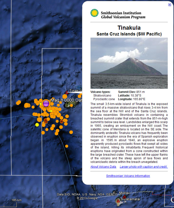
So will this add a volcano into the mix???
(The white lines are the FE region boundaries.)
I think you / muzzy are most likely right when you say that it will take a long time to sort out / this may be 2 x 7.9
There will be several additions/deletions I feel but at least it should settle down into an aftershock pattern now and give the resident of the Islands some peace! (for a while)
So will this add a volcano into the mix???
(The white lines are the FE region boundaries.)
edit on 6/2/2013 by PuterMan because: (no reason given)
reply to post by wujotvowujotvowujotvo
thanks for the link to GCMT, saved me filling in the form
see the 2 x 7's aftershocks in Mw.
I wonder why USGS has not converted these from mb.
GFZ had them in Mw right away.
Are they trying to downplay the seriousness of this series I wonder?
thanks for the link to GCMT, saved me filling in the form
see the 2 x 7's aftershocks in Mw.
201302060123A SANTA CRUZ ISLANDS REGIO
Date: 2013/ 2/ 6 Centroid Time: 1:23:30.2 GMT
Lat= -11.26 Lon= 164.84
Depth= 20.2 Half duration= 8.3
Centroid time minus hypocenter time: 10.5
Moment Tensor: Expo=26 -4.950 0.472 4.470 0.217 1.290 -1.400
Mw = 7.1 mb = 0.0 Ms = 6.4 Scalar Moment = 5.1e+26
Fault plane: strike=336 dip=39 slip=-100
Fault plane: strike=169 dip=52 slip=-82
201302060154A SANTA CRUZ ISLANDS
Date: 2013/ 2/ 6 Centroid Time: 1:54:23.3 GMT
Lat= -10.40 Lon= 165.56
Depth= 14.4 Half duration= 7.7
Centroid time minus hypocenter time: 8.1
Moment Tensor: Expo=26 -0.148 2.520 -2.370 0.241 -0.731 -2.930
Mw = 7.0 mb = 0.0 Ms = 6.6 Scalar Moment = 3.89e+26
Fault plane: strike=70 dip=79 slip=-179
Fault plane: strike=340 dip=89 slip=-11
I wonder why USGS has not converted these from mb.
GFZ had them in Mw right away.
Are they trying to downplay the seriousness of this series I wonder?
edit on 6-2-2013 by muzzy because: (no reason given)
They have converted one of them now
Location in Google Maps
Derived from Event Data Source: USGS
Powered by QVSData
This was the 6.6 mb
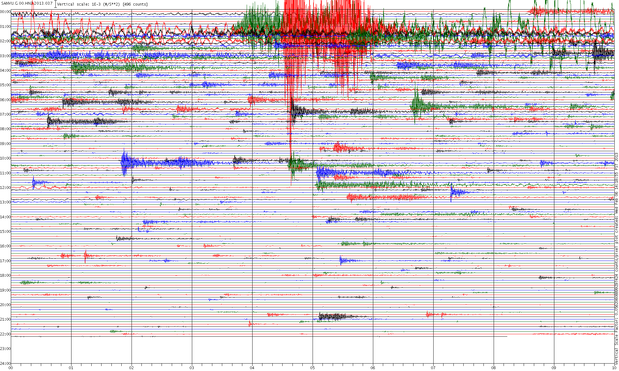
Here is the SANVU seismogram for the day so far (click for a very much larger image 1200 high x 2000 wide I have just added (22:20 UTC)
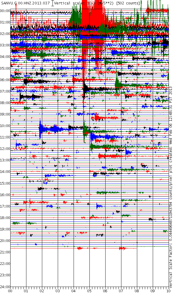
The spectrogram signals compared to disatnce and size are quite interesting. The Mag 8 @01:12 is about the same distance from the station as the Mag 7 @01:54 (Just 15 km in it) and not a huge difference in the signal yet the Mag 7 (Currently 6.4 mb USGS) shows very much stronger even though it is only 40km closer. Maybe it is because it is the other side of the trench?
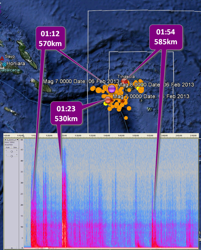
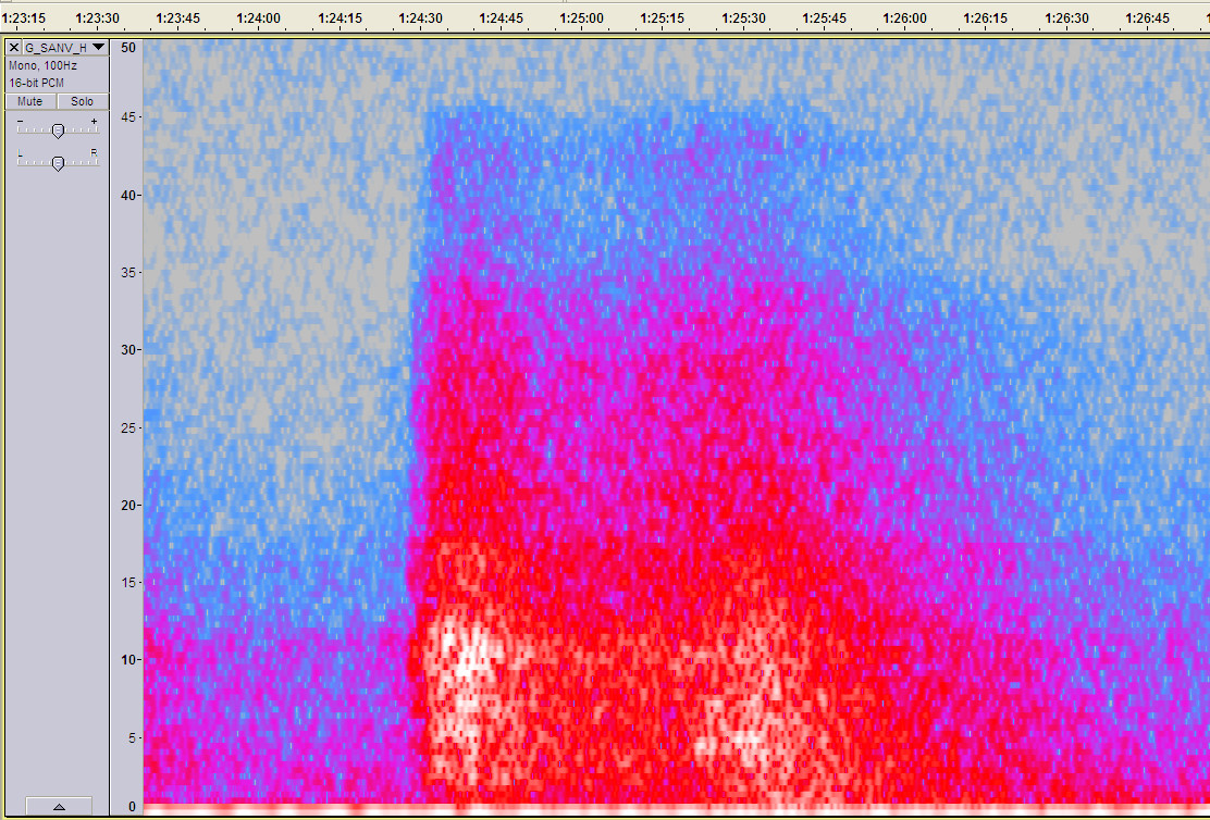
That 01:23 also appears to be two events with about 1 minute separation (click for larger image). No one has posted the second yet. Of course it could just be a large surface wave rolling through.
ETA: Should have checked first.
neic.usgs.gov...
Magnitude 7.0 - Santa Cruz Islands
Location in Google Maps
- Date-Time: Wednesday, February 06, 2013 @ 01:54:15 UTC
- Earthquake location: 10.479°S, 165.772°E,
- Earthquake depth: 9.8 km
- Distances:
27km (16mi) NNW of Lata, Solomon Islands
579km (359mi) NNW of Luganville, Vanuatu
648km (402mi) E of Honiara, Solomon Islands
848km (526mi) NNW of Port-Vila, Vanuatu
1166km (724mi) N of We, New Caledonia
- Event ID: usc000f1ts
Derived from Event Data Source: USGS
Powered by QVSData
This was the 6.6 mb
Here is the SANVU seismogram for the day so far (click for a very much larger image 1200 high x 2000 wide I have just added (22:20 UTC)
The spectrogram signals compared to disatnce and size are quite interesting. The Mag 8 @01:12 is about the same distance from the station as the Mag 7 @01:54 (Just 15 km in it) and not a huge difference in the signal yet the Mag 7 (Currently 6.4 mb USGS) shows very much stronger even though it is only 40km closer. Maybe it is because it is the other side of the trench?
That 01:23 also appears to be two events with about 1 minute separation (click for larger image). No one has posted the second yet. Of course it could just be a large surface wave rolling through.
ETA: Should have checked first.
HNR ePn 01:24:37.42 -0.4X 5.2 290 HNR
eSn 01:25:42.27 S res = 4.3
neic.usgs.gov...

edit on 6/2/2013 by PuterMan because: (no reason given)
I know everyone is focused on these big quakes but today there was a 2.9 near Sutter CA. No big deal except its about 30 miles above Folsom dam. I
know someone who lives right near the dam and they felt the shaking.
You don't want a quake around that dam, it could send a wall of water in populated valley within minutes.
You don't want a quake around that dam, it could send a wall of water in populated valley within minutes.
reply to post by Cherryontop
As far as I can tell it must be this one
Location in Google Maps
Derived from Event Data Source: USGS
Powered by QVSData
That seems to be about 38 miles from the Folsom dam.
Anyone know what this area is? (Click for slightly bigger image)
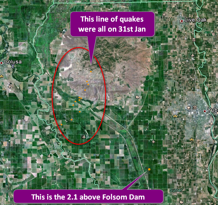
As far as I can tell it must be this one
Magnitude 2.1 - Northern California
Location in Google Maps
- Date-Time: Wednesday, February 06, 2013 @ 18:59:04 UTC
- Earthquake location: 39.054°N, 121.725°W,
- Earthquake depth: 21.3 km
- Distances:
10km (6mi) SW of South Yuba City, California
13km (8mi) SW of Yuba City, California
15km (9mi) WSW of Olivehurst, California
15km (9mi) SW of Marysville, California
56km (34mi) NNW of Sacramento, California
- Event ID: nc71932625
Derived from Event Data Source: USGS
Powered by QVSData
That seems to be about 38 miles from the Folsom dam.
Anyone know what this area is? (Click for slightly bigger image)

edit on 6/2/2013 by PuterMan because: (no reason given)
new topics
-
University of Texas Instantly Shuts Down Anti Israel Protests
Education and Media: 1 hours ago -
Any one suspicious of fever promotions events, major investor Goldman Sachs card only.
The Gray Area: 3 hours ago -
God's Righteousness is Greater than Our Wrath
Religion, Faith, And Theology: 7 hours ago -
Electrical tricks for saving money
Education and Media: 11 hours ago
top topics
-
VP's Secret Service agent brawls with other agents at Andrews
Mainstream News: 12 hours ago, 10 flags -
Cats Used as Live Bait to Train Ferocious Pitbulls in Illegal NYC Dogfighting
Social Issues and Civil Unrest: 16 hours ago, 8 flags -
Nearly 70% Of Americans Want Talks To End War In Ukraine
Political Issues: 13 hours ago, 4 flags -
Sunak spinning the sickness figures
Other Current Events: 13 hours ago, 4 flags -
Electrical tricks for saving money
Education and Media: 11 hours ago, 4 flags -
Late Night with the Devil - a really good unusual modern horror film.
Movies: 15 hours ago, 2 flags -
Any one suspicious of fever promotions events, major investor Goldman Sachs card only.
The Gray Area: 3 hours ago, 2 flags -
University of Texas Instantly Shuts Down Anti Israel Protests
Education and Media: 1 hours ago, 1 flags -
God's Righteousness is Greater than Our Wrath
Religion, Faith, And Theology: 7 hours ago, 0 flags
active topics
-
Any one suspicious of fever promotions events, major investor Goldman Sachs card only.
The Gray Area • 7 • : seekshelter -
Nearly 70% Of Americans Want Talks To End War In Ukraine
Political Issues • 34 • : crayzeed -
Hate makes for strange bedfellows
US Political Madness • 42 • : network dude -
University of Texas Instantly Shuts Down Anti Israel Protests
Education and Media • 2 • : pianopraze -
Sunak spinning the sickness figures
Other Current Events • 12 • : andy06shake -
-@TH3WH17ERABB17- -Q- ---TIME TO SHOW THE WORLD--- -Part- --44--
Dissecting Disinformation • 663 • : MetalThunder -
Russia Ukraine Update Thread - part 3
World War Three • 5731 • : Freeborn -
President BIDEN Vows to Make Americans Pay More Federal Taxes in 2025 - Political Suicide.
2024 Elections • 137 • : CriticalStinker -
I think this life means something.
Philosophy and Metaphysics • 59 • : seekshelter -
Late Night with the Devil - a really good unusual modern horror film.
Movies • 5 • : chiefsmom