It looks like you're using an Ad Blocker.
Please white-list or disable AboveTopSecret.com in your ad-blocking tool.
Thank you.
Some features of ATS will be disabled while you continue to use an ad-blocker.

Quake Watch 2013
page: 19share:
reply to post by MariaLida
2013-01-27 20:57:31.7 13min ago 27.49 N 128.29 E 10 5.2 RYUKYU ISLANDS, JAPAN
Magnitude M 5.2
Region RYUKYU ISLANDS, JAPAN
Date time 2013-01-27 20:57:36.0 UTC
Location 27.47 N ; 128.28 E
Depth 60 km
Distances 710 km S Fukuoka (pop 1,392,289 ; local time 05:57:36.7 2013-01-28)
135 km N Okinawa (pop 125,483 ; local time 05:57:36.7 2013-01-28)
102 km N Nago (pop 59,587 ; local time 05:57:36.7 2013-01-28)
www.emsc-csem.org...
nevermind
edit on 1/27/2013 by Olivine because: (no reason given)
GFZ Potsdam detected a Wyoming earthquake before USGS
geofon.gfz-potsdam.de/eqinfo/event.php?id=gfz2013bxag
geofon.gfz-potsdam.de/eqinfo/event.php?id=gfz2013bxag
Originally posted by wujotvowujotvowujotvo
GFZ Potsdam detected a Wyoming earthquake before USGS
geofon.gfz-potsdam.de/eqinfo/event.php?id=gfz2013bxag
Nop that report was before 3 hrs, nothing from USGS ..
Only GFZ report this ..
2013-01-27 19:47:06.6 3hr 37min ago 44.32 N 105.27 W 10 4.4 WYOMING
www.emsc-csem.org...
Magnitude M 4.4
Region WYOMING
Date time 2013-01-27 19:47:06.6 UTC
Location 44.32 N ; 105.27 W
Depth 10 km
Distances 1334 km NE Phoenix (pop 1,428,509 ; local time 12:47:06.6 2013-01-27)
418 km NW Fort collins (pop 129,252 ; local time 12:47:06.6 2013-01-27)
20 km E Gillette (pop 23,101 ; local time 12:47:06.6 2013-01-27)
15 km NE Sleepy hollow (pop 1,154 ; local time 12:47:06.6 2013-01-27)
edit on 27-1-2013 by MariaLida because: (no reason given)
Looks like was really EQ but way USGS did not report hmm ..
Can't find closer seismogram to EQ report ..
19:47:06.6 UTC
www.isthisthingon.org...
www.isthisthingon.org...
quake.utah.edu...
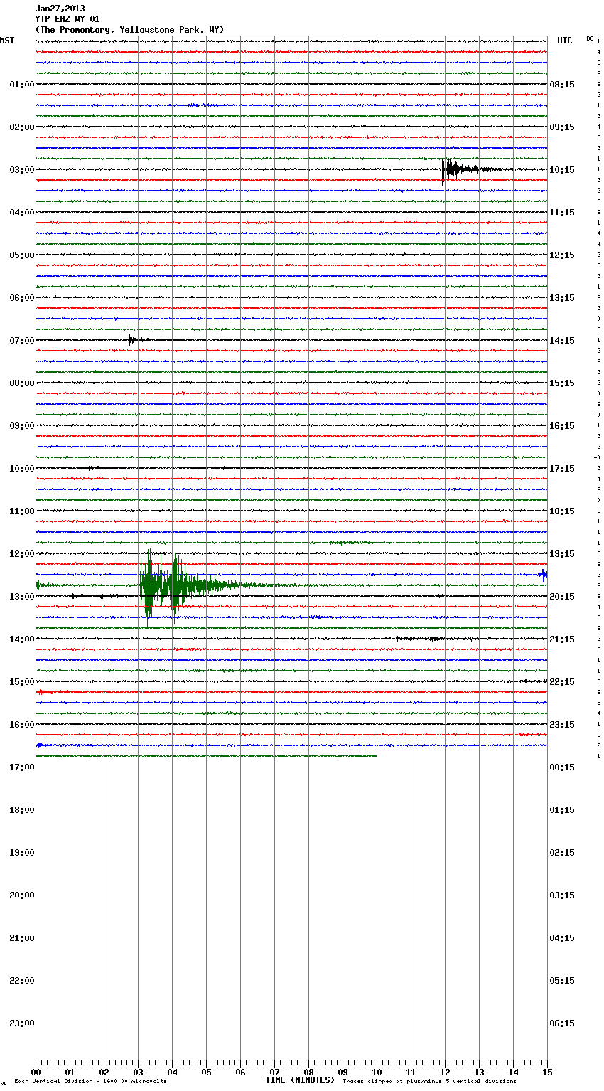
www.emsc-csem.org...
Can't find closer seismogram to EQ report ..
19:47:06.6 UTC
www.isthisthingon.org...
www.isthisthingon.org...
quake.utah.edu...
www.emsc-csem.org...
edit on 27-1-2013 by MariaLida because: (no reason given)
reply to post by MariaLida
It looks like that may have been a false trigger due to the mag 5.2 Southern East Pacific Rise quake at 19:32:41UTC. Looking at the estimated travel time of 12/13 minutes for the first P-waves to hit Wyoming, it seems close.
It looks like that may have been a false trigger due to the mag 5.2 Southern East Pacific Rise quake at 19:32:41UTC. Looking at the estimated travel time of 12/13 minutes for the first P-waves to hit Wyoming, it seems close.
Originally posted by muzzy
Hokkaido/ Eastern Sea of Japan 22/01/2013 mag 4.9 - 5.8
Geez NIED sure went over the top on that one, never seen them be so far away from what JMA eventually put on their page.
Will have to wait 3 days for reviewed data on that.
(click on table for interactive map)
learned a new trick , been testing it at Japan Preliminary Earthquake Maps NIED
www.jma.go.jp...edit on 23-1-2013 by muzzy because: (no reason given)
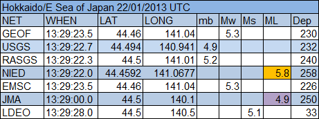
Well NIED came in at 5.4Mw for this one on the 3 day review.
Originally posted by Olivine
reply to post by MariaLida
It looks like that may have been a false trigger due to the mag 5.2 Southern East Pacific Rise quake at 19:32:41UTC. Looking at the estimated travel time of 12/13 minutes for the first P-waves to hit Wyoming, it seems close.
Thank you for sharing that info but I don't think so ..
Report was too far from Pacific Rise EQ also was not strong one ..
reply to post by muzzy
Darn I hate it when these people do this unannounced. Now I have going to have to go and check if the Chile collection in the QVSData program works.
If it it ain't broke, don't fix it. Motto of the Taureans. (Along with never do today what you can put off until tomorrow)
The Geophysical report for this week is done - the earthquake part. This thing is getting to be a monster and takes up vast amounts of time. The report is split into two parts now with quakes and then volcanoes and storms in another post.
Because I have nothing better to do and time hangs heavy on my hands I have embarked on a massive project to show, or not, that earthquakes are on the decrease. I have started at 2002 and am now up to 2007. It involves creating a slot for each day, adding the energy for Mag 6 quakes on that day and then converting back to a magnitude. The global rolling magnitude equivalent is then charted, along with the rolling number of events and the rolling days between events.
So far it has taken 2 full days so don't expect the results before next week at the earliest. Then I have to do Mag 7, and Mag 8+
Needles to say I will not even attempt Mag 5s. Once I have 2002 - 2013 I want to work backwards as far as I can (1970?)
edit on 28/1/2013 by PuterMan because: (no reason given)
reply to post by MariaLida
Not reported because it is most likely a mining explosion. First the location is Gillette. That should be a big clue as they have a tendency to blow things up around those parts.
Second, USGS have not reported a 4.4? Unlikely. Yes the event did happen - no doubt about that but I suspect that EMSC and Potsdam are erroneously attributing this to a quake OR USGS have not published yet because they are deciding which it is.
Not on the Mining blasts list yet however.
More info: The lists are updated at 3am Mountain time (UTC -7) so the last update was 2000 UTC on the 27th and therefore before the event. It will be on the next update I have no doubt.
ETA: You can check out once they do appear using the phase data for the blasts
edit on 28/1/2013 by PuterMan because: (no reason given)
reply to post by PuterMan
Hey Puterman, I sympathize with you on the work, very time consuming. I feel for ya, but it's too bad that you aren't doing the small quakes. I'm not sure how others feel, but for me I'm already convinced the larger quakes aren't on the rise. It's the smaller quakes I question.
Hey Puterman, I sympathize with you on the work, very time consuming. I feel for ya, but it's too bad that you aren't doing the small quakes. I'm not sure how others feel, but for me I'm already convinced the larger quakes aren't on the rise. It's the smaller quakes I question.
reply to post by Rezlooper
I hear what you are saying, but globally the small quakes are not significant if we are talking about < Mag 5. It is a possibility that I could eventually include Mag 5, but the problem there is that as far as I am concerned Mag 5 data from USGS is NOT complete, especially if one is looking at converting mb values to Mw (approximately) to try and get some sort of level playing field.
I don't believe that it would be possible to get an accurate figure and bear in mind that on USGS quake (converted) we are looking at well in excess of 6000 quakes a year. At around 17 events daily that is a massive amount of effort to get what would probably be an inaccurate result.
In my opinion Mag 5 and under are essentially local events and need to be treated as such. I have enough problem keeping up with the global events, let alone doing localised investigations - much as I would like to!
PS there is Mag 5 stuff in the Geophysical but it won't be in the 2002-2013 charts I think unless I can find a way to speed this up (I am working on it)
edit on 28/1/2013 by PuterMan because: (no reason given)
Magnitude 6.0 - Eastern Kazakhstan
Location in Google Maps
- Date-Time: Monday, January 28, 2013 @ 16:38:53 UTC
- Earthquake location: 42.604°N, 79.696°E,
- Earthquake depth: 10.9 km
- Distances:
60km (37mi) SE of Kegen, Kazakhstan
107km (66mi) E of Karakol, Kyrgyzstan
109km (67mi) E of Tyup, Kyrgyzstan
142km (88mi) ENE of Kyzyl-Suu, Kyrgyzstan
419km (260mi) E of Bishkek, Kyrgyzstan
- Event ID: usc000ewqq
Derived from Event Data Source: USGS
Powered by QVSData
Originally posted by Rezlooper
reply to post by PuterMan
Hey Puterman, I sympathize with you on the work, very time consuming. I feel for ya, but it's too bad that you aren't doing the small quakes. I'm not sure how others feel, but for me I'm already convinced the larger quakes aren't on the rise. It's the smaller quakes I question.
I agree, the large quakes may be on the decline but I am seeing more small ones. especially in the U S and near active volcanoes worldwide.
@PuterMan - It has been one hell of a weekend for me. I spent most of it in bed on pain killers. I haven't forgot our little discourse but it will take some time to get back to it. I do want to go through the Excel file of Nevada area quakes first since one of my points pivots on them. And that will take some time considering the size of the file.
Earthquake unnerves Kazakhstan's largest city
AP – 2 minutes ago
www.google.com...
2013-01-28 17:09:21.41hr 11min ago 42.63 N 79.61 E 1 4.3 EASTERN KAZAKHSTAN
2013-01-28 16:38:53.01hr 41min ago 42.64 N 79.76 E 10 6.1 EASTERN KAZAKHSTAN
www.emsc-csem.org... ; static2.emsc.eu... ; static2.emsc.eu...
GFZ also report M 6.1 ..
geofon.gfz-potsdam.de...
AP – 2 minutes ago
ALMATY, Kazakhstan (AP) — A magnitude 6.0 earthquake has hit southeastern Kazakhstan, causing apartment buildings to sway in the country's largest city, Almaty.
The shallow tremors were also felt in the capital of neighboring Kyrgyzstan. No damage had been reported by late Monday.
www.google.com...
2013-01-28 17:09:21.41hr 11min ago 42.63 N 79.61 E 1 4.3 EASTERN KAZAKHSTAN
2013-01-28 16:38:53.01hr 41min ago 42.64 N 79.76 E 10 6.1 EASTERN KAZAKHSTAN
www.emsc-csem.org... ; static2.emsc.eu... ; static2.emsc.eu...
GFZ also report M 6.1 ..
geofon.gfz-potsdam.de...
edit on 28-1-2013 by MariaLida because: (no reason given)
State lawmaker backs early earthquake warning system for California
January 28, 2013 | 8:31 am
latimesblogs.latimes.com...
January 28, 2013 | 8:31 am
A state lawmaker is proposing legislation that would seek to create an early earthquake warning system for California. Details were expected to be released at a news conference Monday.
Earthquake experts welcomed the attention from Sacramento. California has struggled to develop an early warning system that can give seconds of crucial warning that an earthquake is headed their way.
Japan and Mexico have already established quake warning systems. An extensive warning system would require the construction of a network of sensors in the ground. When waves from a quake start moving through the ground, electronic signals -- which move far faster than a quake itself -- can send an alert that the shaking will come soon.
A temblor along the San Andreas fault around the Salton Sea, for instance, could give up to a full minute of warning time before shaking occurred in Los Angeles.
Researchers have been testing a prototype in California called Shake Alert, but the system still has “fragilities that would probably not allow it to work during a very large earthquake,” Given said.
latimesblogs.latimes.com...
edit on 28-1-2013 by MariaLida
because: (no reason given)
Garfagnana Update at 72:23:54 (h:mm:ss) after Main shock
[color=lime](click image for interactive map, opens in new tab/window)
Summary
mag
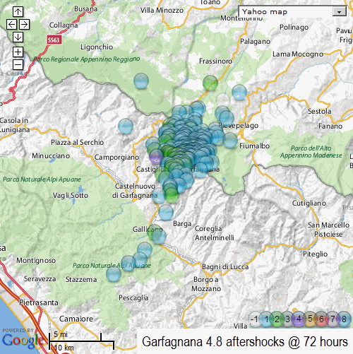
[color=lime](click image for interactive map, opens in new tab/window)
Summary
mag
This seems like the best place to ask this question as i am certain i will get a proper answer.
Could this be related to the possible explosion at the Fordow Nuclear Facility?
More Info Here
It seems to be about 20 minutes after that this is reported.
M5.3 - 38km ENE of Kerman, Iran
2013-01-21 19:49:02 UTC
Iran - USGS
Could this be related to the possible explosion at the Fordow Nuclear Facility?
More Info Here
According to a source in the security forces protecting Fordow, an explosion on Monday at 11:30 a.m. Tehran time rocked the site, which is buried deep under a mountain and immune not only to airstrikes but to most bunker-buster bombs. The report of the blast came via Hamidreza Zakeri, formerly with the Islamic regime’s Ministry of Intelligence and National Security, The blast shook facilities within a radius of three miles. Security forces have enforced a no-traffic radius of 15 miles, and the Tehran-Qom highway was shut down for several hours after the blast, the source said.
It seems to be about 20 minutes after that this is reported.
M5.3 - 38km ENE of Kerman, Iran
2013-01-21 19:49:02 UTC
Iran - USGS
edit on 28-1-2013 by Thorneblood because: (no reason given)
Originally posted by Thorneblood
This seems like the best place to ask this question as i am certain i will get a proper answer.
Could this be related to the possible explosion at the Fordow Nuclear Facility?
More Info Here
According to a source in the security forces protecting Fordow, an explosion on Monday at 11:30 a.m. Tehran time rocked the site, which is buried deep under a mountain and immune not only to airstrikes but to most bunker-buster bombs. The report of the blast came via Hamidreza Zakeri, formerly with the Islamic regime’s Ministry of Intelligence and National Security, The blast shook facilities within a radius of three miles. Security forces have enforced a no-traffic radius of 15 miles, and the Tehran-Qom highway was shut down for several hours after the blast, the source said.
It seems to be about 20 minutes after that this is reported.
M5.3 - 38km ENE of Kerman, Iran
2013-01-21 19:49:02 UTC
Iran - USGS
edit on 28-1-2013 by Thorneblood because: (no reason given)
I thought the same, but I was too lazy to check the times, because I am in my exam period right now and have a lot of work to do
edit on 28-1-2013 by aLLeKs because: (no reason given)
reply to post by Thorneblood
Don't think so, It's more of 10 hrs differences also locations ..
Kerman - Iran
GMT +3:30
localtimes.info...
The alleged blast was said to have erupted at 11.30am last Monday, that' was 09:00am UTC ..
EQ was 2013-01-21 19:49:03.0, 43 km E of Kerman ..
www.telegraph.co.uk...
rt.com...
www.emsc-csem.org...
static2.emsc.eu...
edit on 28-1-2013 by MariaLida because: (no reason given)
new topics
-
whistleblower Captain Bill Uhouse on the Kingman UFO recovery
Aliens and UFOs: 3 hours ago -
1980s Arcade
General Chit Chat: 5 hours ago -
Deadpool and Wolverine
Movies: 6 hours ago -
Teenager makes chess history becoming the youngest challenger for the world championship crown
Other Current Events: 7 hours ago -
CIA botched its handling of sexual assault allegations, House intel report says
Breaking Alternative News: 8 hours ago -
Lawsuit Seeks to ‘Ban the Jab’ in Florida
Diseases and Pandemics: 10 hours ago
top topics
-
Lawsuit Seeks to ‘Ban the Jab’ in Florida
Diseases and Pandemics: 10 hours ago, 20 flags -
Starburst galaxy M82 - Webb Vs Hubble
Space Exploration: 12 hours ago, 12 flags -
The Superstition of Full Moons Filling Hospitals Turns Out To Be True!
Medical Issues & Conspiracies: 14 hours ago, 8 flags -
CIA botched its handling of sexual assault allegations, House intel report says
Breaking Alternative News: 8 hours ago, 8 flags -
whistleblower Captain Bill Uhouse on the Kingman UFO recovery
Aliens and UFOs: 3 hours ago, 6 flags -
15 Unhealthiest Sodas On The Market
Health & Wellness: 13 hours ago, 5 flags -
Teenager makes chess history becoming the youngest challenger for the world championship crown
Other Current Events: 7 hours ago, 3 flags -
Deadpool and Wolverine
Movies: 6 hours ago, 3 flags -
1980s Arcade
General Chit Chat: 5 hours ago, 3 flags
active topics
-
Definitive 9.11 Pentagon EVIDENCE.
9/11 Conspiracies • 419 • : SchrodingersRat -
They Killed Dr. Who for Good
Rant • 61 • : Cymru -
How ageing is" immune deficiency"
Medical Issues & Conspiracies • 26 • : RookQueen2 -
The Democrats Take Control the House - Look what happened while you were sleeping
US Political Madness • 105 • : SchrodingersRat -
Starburst galaxy M82 - Webb Vs Hubble
Space Exploration • 4 • : SchrodingersRat -
Non-Human Operate Within The Visual Spectrum 'We Cannot See' - ULTRATERRESTRIALS EXIST!
Paranormal Studies • 136 • : burritocat -
New whistleblower Jason Sands speaks on Twitter Spaces last night.
Aliens and UFOs • 39 • : RookQueen2 -
23,000 Dead People Registered Within a Two Week Period In One State
US Political Madness • 39 • : Audreagassulke -
1980s Arcade
General Chit Chat • 7 • : Freeborn -
Europe declares war on Russia?
World War Three • 59 • : Freeborn