It looks like you're using an Ad Blocker.
Please white-list or disable AboveTopSecret.com in your ad-blocking tool.
Thank you.
Some features of ATS will be disabled while you continue to use an ad-blocker.

Quake Watch 2013
page: 141share:
reply to post by Olivine
cool, I see the bigger S even for the smaller quake
yes I got all riled up with about the new version of ATS ( didn't like the test run) but decided to get with the youngsters and changed my signature ( no colours) and then changed my avatar as well
its the "confused" smiley
but I'm still getting the old ATS now, 5 days after the launch was supposed to happen
Magnitude mb 4.8
Region ROMANIA
Date time 2013-09-08 13:22:13.0 UTC
Location 45.58 N ; 22.88 E
Depth 2 km
Distances 208 km NE of Belgrade, Serbia / pop: 1,273,651 / local time: 15:22:13.0 2013-09-08
18 km S of Hunedoara, Romania / pop: 69,136 / local time: 16:22:13.0 2013-09-08
1 km N of Toteşti, Romania / pop: 1,990 / local time: 16:22:13.0 2013-09-08
Emsc
any time I want a bit of a laugh I go read EMSC felt reports.
from this quake
CRETE, GREECE
Magnitude: 5.0mb
Depth: 10 km
Date time 2013-09-08 04:59:30.0 UTC
Location 34.80 N ; 25.01 E
maybe things get lost in translation, but I find it pretty amazing that someone can know they are about to wake up while they are still asleep
I find I just wake up without any premonitions or plans to do so
from this quake
CRETE, GREECE
Magnitude: 5.0mb
Depth: 10 km
Date time 2013-09-08 04:59:30.0 UTC
Location 34.80 N ; 25.01 E
Witness location : Heraklion (Greece) (61 km N from epicenter)
I was just about to wake up when I was alarmed by the faint tremble and noise
to me, it was of instant duration (`2 sec)
maybe things get lost in translation, but I find it pretty amazing that someone can know they are about to wake up while they are still asleep
I find I just wake up without any premonitions or plans to do so
edit on 8-9-2013 by muzzy because: maybe they meant "get up"
www.emsc-csem.org... 5.7 initial report Hawaii Island region
phew update saying 5.0
phew update saying 5.0
edit on 8-9-2013 by slidingdoor because: (no reason given)
reply to post by muzzy
Central European Summer Time = UTC +2 makes it 7am. Alarm set for 7 am probably so just about to wake up when the quake did it instead of the alarm clock.
Just my guess.
but I find it pretty amazing that someone can know they are about to wake up while they are still asleep
Central European Summer Time = UTC +2 makes it 7am. Alarm set for 7 am probably so just about to wake up when the quake did it instead of the alarm clock.
Just my guess.
Alert for NZ. Energy Released on 08/09/2013 was below 10, at 8.372TTNT
usually within a few days a m5+ hits
just a quick glnce at GFZ list shows the whole planet is pretty quiet, m5.2 x 2 at Santa Cruz Is the biggest
NB the new ATS style kicked in this morning here when I opened........... I was ready with my minimalist avatar and colourless signature
next thing you know I'll be getting a smart phone so I can post from work at 49c a minute
edit on 9-9-2013 by muzzy because: (no reason
given)
What is with all these quarry blasts today... I notice Useless is showing them as triangles now? I can't sort them but here is a couple from
today.
1.5
Quarry Blast 5km S of Princeton, Canada
2013-09-10 17:16:23 UTC-04:000.0 km
1.1
Quarry Blast 2km WSW of Quarry at CUSHENBURY
2013-09-10 16:13:02 UTC-04:000.0 km
1.6
Quarry Blast 4km NNE of Yakima, Washington
2013-09-10 15:08:28 UTC-04:000.0 km
1.4
Quarry Blast 0km WSW of Quarry at MOJAVE
2013-09-10 13:23:48 UTC-04:000.0 km
1.1
Quarry Blast 3km WSW of Quarry at CUSHENBURY
2013-09-10 11:36:45 UTC-04:000.0 km
further to post by muzzy
doesn't really count though, as is located 3/4 the distance to Raoul Island.
Still on ALERT, take that quakes value of 604.795 TTNT off the daily total of 609.411TTNT for the 10th Sept UTC leaves just 4.616TTNT, which is not much, and only 27 quakes total too, thats like the old 1-2 a day low count before Geonets SeisComp3 came on line with the auto readings in 2012.
5.07ML
2013p683303
10/09/2013 19:43:14
-178.8011 -33.731
52.1 km
South Of Kermadec Islands
www.geonet.org.nz...
doesn't really count though, as is located 3/4 the distance to Raoul Island.
Still on ALERT, take that quakes value of 604.795 TTNT off the daily total of 609.411TTNT for the 10th Sept UTC leaves just 4.616TTNT, which is not much, and only 27 quakes total too, thats like the old 1-2 a day low count before Geonets SeisComp3 came on line with the auto readings in 2012.
edit on 11-9-2013 by muzzy because: didn't like the Font in the ex tags so I changed the whole post to The Great Escape Font just to be
annoying
reply to post by steve95988
Oh? odd in what way?
 (click image for interactive map, opens in new tab/window)
results ANSS 22/08/1963 to today, 500km radius from -4.6484,-104.8181, m4+
mag4= 246 , mag5= 116 , mag6= 12 , total= 374
Oh? odd in what way?
results ANSS 22/08/1963 to today, 500km radius from -4.6484,-104.8181, m4+
mag4= 246 , mag5= 116 , mag6= 12 , total= 374
One positive thing out of the new ATS 5.3 version is that when you upload images, the latest added are first.
Saves scrolling kilometers down the page to get your url for the image
Saves scrolling kilometers down the page to get your url for the image
reply to post by muzzy
well you must fell special to correct others wrongs... to me it seemed an odd quake as in recent activity..
wwooww
well you must fell special to correct others wrongs... to me it seemed an odd quake as in recent activity..
wwooww
Never mind...fried brain!
WOQ
WOQ
edit on 11-9-2013 by wasobservingquietly because: (no reason given)
reply to post by steve95988
you presuppose that recent activity is connected in some way?
what way?
perhaps this is more likely the start of a new set of activity, because this was on a spreading ridge, not quite in the middle of the Pacific Ocean
you presuppose that recent activity is connected in some way?
what way?
perhaps this is more likely the start of a new set of activity, because this was on a spreading ridge, not quite in the middle of the Pacific Ocean
edit on 12-9-2013 by muzzy because: (no reason given)
California Major Quake might occur with in .....Twin Valley and Goat Mountain. Activity is high here.
39.232 N 122.716 W Location.
Activity so far
M2.4 - 16km NE of Nice, California
2013-09-12 19:02:02 UTC
Location
39.234°N 122.722°W depth=0.1km (0.1mi)
Nearby Cities
16km (10mi) NE of Nice, California
31km (19mi) NNW of Clearlake, California
43km (27mi) ENE of Ukiah, California
70km (43mi) N of Healdsburg, California
128km (80mi) NW of Sacramento, California
and then
M3.4 - 17km NNE of Lucerne, California
2013-09-12 19:02:43 UTC
Location
39.227°N 122.703°W depth=12.3km (7.6mi)
Nearby Cities
17km (11mi) NNE of Lucerne, California
30km (19mi) NNW of Clearlake, California
44km (27mi) ENE of Ukiah, California
69km (43mi) NNE of Healdsburg, California
126km (78mi) NW of Sacramento, California
now this
M2.1
16km NNE of Lucerne, California
2013-09-12 12:25:18 UTC-07:006.3 km
Location
39.233°N 122.725°W depth=6.3km (3.9mi)
Nearby Cities
16km (10mi) NNE of Lucerne, California
31km (19mi) NNW of Clearlake, California
42km (26mi) ENE of Ukiah, California
70km (43mi) N of Healdsburg, California
128km (80mi) NW of Sacramento, California
Total quake list in area
M2.2
15km NE of Nice, California
2013-09-12 12:26:27 UTC-07:004.9 km
M2.1
16km NNE of Lucerne, California
2013-09-12 12:25:18 UTC-07:006.3 km
M3.4
17km NNE of Lucerne, California
2013-09-12 12:02:43 UTC-07:0012.3 km
M2.4
16km NE of Nice, California
2013-09-12 12:02:02 UTC-07:000.1 km
M2.2
16km NNE of Lucerne, California
2013-09-12 12:00:49 UTC-07:007.2 km
M2.3
16km NE of Nice, California
2013-09-12 10:52:44 UTC-07:005.7 km
earthquake.usgs.gov... ain%22%2C%22autoUpdate%22%3Atrue%2C%22restrictListToMap%22%3Atrue%2C%22timeZone%22%3A%22local%22%2C%22mapposition%22%3A%5B%5B39.08557063444842%2C237.1 4401245117185%5D%2C%5B39.30056486146251%2C237.55874633789062%5D%5D%2C%22overlays%22%3A%7B%22plates%22%3Atrue%7D%2C%22viewModes%22%3A%7B%22map%22%3Atru e%2C%22list%22%3Atrue%2C%22settings%22%3Afalse%2C%22help%22%3Afalse%7D%7D
Another area to watch is
Location 38.805 N 122.787 W
Mayacmas Mountains
List of quakes in this area
M0.9
7km WNW of Cobb, California
2013-09-12 12:20:59 UTC-07:002.6 km
M0.3
1km WSW of Cobb, California
2013-09-12 10:48:38 UTC-07:003.4 km
M2.0
1km SW of Cobb, California
2013-09-12 10:44:59 UTC-07:002.4 km
M1.0
6km NW of The Geysers, California
2013-09-12 09:49:35 UTC-07:003.6 km
M1.1
5km NW of The Geysers, California
2013-09-12 09:48:16 UTC-07:003.9 km
M1.0
8km NW of The Geysers, California
2013-09-12 09:22:35 UTC-07:002.7 km
M0.4
1km ENE of The Geysers, California
2013-09-12 05:42:21 UTC-07:002.2 km
M1.2
1km ENE of The Geysers, California
2013-09-12 04:19:23 UTC-07:001.9 km
M1.0
6km NW of The Geysers, California
2013-09-12 03:22:06 UTC-07:002.6 km
M1.4
8km NW of The Geysers, California
2013-09-12 03:17:03 UTC-07:002.7 km
M0.6
4km WNW of The Geysers, California
2013-09-12 02:02:50 UTC-07:004.9 km
M0.2
10km W of Cobb, California
2013-09-12 01:06:43 UTC-07:002.2 km
M0.9
8km W of Cobb, California
2013-09-12 01:04:54 UTC-07:002.3 km
M1.2
7km W of Cobb, California
2013-09-12 00:36:31 UTC-07:001.9 km
M1.3
6km WNW of The Geysers, California
2013-09-11 21:53:28 UTC-07:001.1 km
M0.4
9km WNW of Cobb, California
2013-09-11 20:52:45 UTC-07:002.7 km
M0.9
6km NW of The Geysers, California
2013-09-11 18:36:08 UTC-07:003.5 km
0.4
6km WNW of Cobb, California
2013-09-11 17:49:08 UTC-07:001.9 km
M1.8
1km NNW of The Geysers, California
2013-09-11 17:37:13 UTC-07:002.8 km
M1.5
6km NW of The Geysers, California
2013-09-11 16:49:38 UTC-07:003.1 km
M0.5
6km WNW of The Geysers, California
2013-09-11 16:29:38 UTC-07:003.6 km
M0.9
7km NW of The Geysers, California
2013-09-11 15:21:57 UTC-07:003.1 km
M0.6
6km NW of The Geysers, California
2013-09-11 13:33:33 UTC-07:004.0 km
edit on 7/30/2012 by dreamfox1 because: ( )
edit on 7/30/2012 by dreamfox1
because: (no reason given)
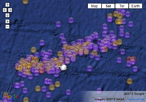
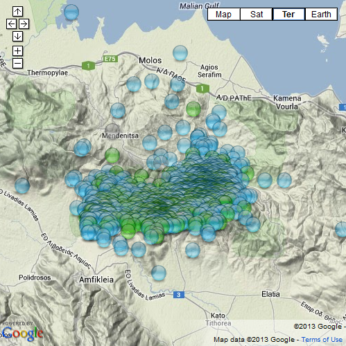
Remember the 5.3Mw of 07/08/2013 near Atalanti, Greece? ( page 121)
F-E Region: Greece
Time: 2013-08-07 09:06:53.5 UTC
Magnitude: 5.3 (Mw)
Epicenter: 22.65°E 38.76°N
Depth: 16 km
up to the end of August, according to NOA, there were;
mag1= 738, ,mag2= 41, mag3=71, mag4= 7
total= 1231 aftershocks
That is quite a few for what is considered a single "moderate" quake !
 (click image for interactive map, opens in new tab/window)
F-E Region: Greece
Time: 2013-08-07 09:06:53.5 UTC
Magnitude: 5.3 (Mw)
Epicenter: 22.65°E 38.76°N
Depth: 16 km
up to the end of August, according to NOA, there were;
mag1= 738, ,mag2= 41, mag3=71, mag4= 7
total= 1231 aftershocks
That is quite a few for what is considered a single "moderate" quake !
Mammoth Lakes Swarm
M0.7
2km ESE of Mammoth Lakes, California
2013-09-12 23:20:13 UTC-07:008.2 km
M2.2
11km E of Mammoth Lakes, California
2013-09-12 23:09:58 UTC-07:008.9 km
M1.4
11km E of Mammoth Lakes, California
2013-09-12 23:07:49 UTC-07:008.6 km
M0.6
11km E of Mammoth Lakes, California
2013-09-12 23:03:39 UTC-07:008.9 km
M0.8
11km E of Mammoth Lakes, California
2013-09-12 22:58:38 UTC-07:009.2 km
M1.8
11km ESE of Mammoth Lakes, California
2013-09-12 22:53:35 UTC-07:002.1 km
M1.9
11km E of Mammoth Lakes, California
2013-09-12 22:49:58 UTC-07:008.7 km
M1.5
11km E of Mammoth Lakes, California
2013-09-12 22:49:13 UTC-07:008.6 km
M1.0
8km E of Mammoth Lakes, California
2013-09-12 22:48:26 UTC-07:003.8 km
M1.2
11km E of Mammoth Lakes, California
2013-09-12 22:47:12 UTC-07:009.4 km
M0.8
12km E of Mammoth Lakes, California
2013-09-12 22:46:43 UTC-07:007.7 km
M1.6
11km E of Mammoth Lakes, California
2013-09-12 22:46:09 UTC-07:009.0 km
M1.5
12km E of Mammoth Lakes, California
2013-09-12 22:45:38 UTC-07:009.1 km
M2.6
11km E of Mammoth Lakes, California
2013-09-12 22:45:07 UTC-07:008.2 km
M1.0
11km E of Mammoth Lakes, California
2013-09-12 22:44:02 UTC-07:008.8 km
M1.2
11km E of Mammoth Lakes, California
2013-09-12 22:43:39 UTC-07:009.1 km
M1.1
0km NW of San Fernando, California
2013-09-12 22:40:59 UTC-07:002.3 km
M1.1
11km E of Mammoth Lakes, California
2013-09-12 22:40:48 UTC-07:008.2 km
M1.1
11km E of Mammoth Lakes, California
2013-09-12 22:39:38 UTC-07:008.9 km
edit on 7/30/2012 by dreamfox1 because:
earthquake.usgs.gov...
ain%22%2C%22autoUpdate%22%3Atrue%2C%22restrictListToMap%22%3Atrue%2C%22timeZone%22%3A%22local%22%2C%22mapposition%22%3A%5B%5B-77.07878389624943%2C-415
.546875%5D%2C%5B83.19489563661588%2C-3.8671874999999996%5D%5D%2C%22overlays%22%3A%7B%22plates%22%3Atrue%7D%2C%22viewModes%22%3A%7B%22map%22%3Atrue%2C%
22list%22%3Atrue%2C%22settings%22%3Afalse%2C%22help%22%3Afalse%7D%7D
edit on 7/30/2012 by dreamfox1 because: (no reason
given)
reply to post by steve95988
I guess it is all a matter of perception. From Muzzy's figures that is an average of 7.48 quakes a year so that suggests that we don't see them pop up all that often, and I admit that when I saw that one I did think it kind of rare.
Perhaps not an oddity as in for example a Mag 6 off the coast of Cornwall (*PM continues amongst the rushing noise of people searching to prove this is not odd*) but rare enough to be noteworthy so no harm done in mentioning it.
On another note and nothing to do with the fact that this is Friday the 13th.
Overnight 157 quakes (sum of four providers) and not one of them a 5+. I always get concerned when the 5s get so low as it often means a big one in the offing.
This chart does not show right up to date as it takes a massive amount of time to process all the data and I have been on this from time to time for several weeks. The chart shows the total of Mag 5 quakes, calculated values as per my Geophysical reports, as 52 week rolling totals thus each point represents a years worth if counts. The numbers for the yearly total rise up and down with the incidence of major quakes, but it is the BIG quakes that seem to affect it worldwide meaning Great quakes (8+) as opposed to Major quakes (7-7.9)
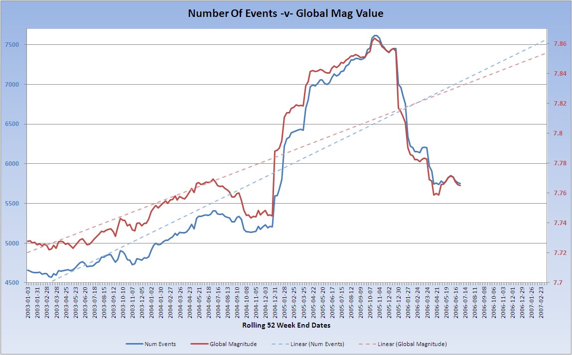
This is only a small lice of data which starts from 2002 and ends 2006 so far but the lowest annual total on this chart is ~4600 counts.
I cannot show you at present but I believe that currently we are at the lowest count of mag 5, (4609) at the end of last week, since the 2002/3 value on the chart.
Does this have significance? Not sure yet as I need to see what happened before the Japan quake but if we don't get a Great quake today I don't think it will be too long (less than a year).
new topics
-
Any one suspicious of fever promotions events, major investor Goldman Sachs card only.
The Gray Area: 2 hours ago -
God's Righteousness is Greater than Our Wrath
Religion, Faith, And Theology: 6 hours ago -
Electrical tricks for saving money
Education and Media: 9 hours ago -
VP's Secret Service agent brawls with other agents at Andrews
Mainstream News: 10 hours ago -
Sunak spinning the sickness figures
Other Current Events: 11 hours ago -
Nearly 70% Of Americans Want Talks To End War In Ukraine
Political Issues: 11 hours ago
top topics
-
VP's Secret Service agent brawls with other agents at Andrews
Mainstream News: 10 hours ago, 9 flags -
Cats Used as Live Bait to Train Ferocious Pitbulls in Illegal NYC Dogfighting
Social Issues and Civil Unrest: 14 hours ago, 8 flags -
Electrical tricks for saving money
Education and Media: 9 hours ago, 4 flags -
Nearly 70% Of Americans Want Talks To End War In Ukraine
Political Issues: 11 hours ago, 3 flags -
Sunak spinning the sickness figures
Other Current Events: 11 hours ago, 3 flags -
Late Night with the Devil - a really good unusual modern horror film.
Movies: 13 hours ago, 2 flags -
Any one suspicious of fever promotions events, major investor Goldman Sachs card only.
The Gray Area: 2 hours ago, 2 flags -
The Good News According to Jesus - Episode 1
Religion, Faith, And Theology: 16 hours ago, 1 flags -
God's Righteousness is Greater than Our Wrath
Religion, Faith, And Theology: 6 hours ago, 0 flags
active topics
-
Sunak spinning the sickness figures
Other Current Events • 9 • : Ohanka -
God's Righteousness is Greater than Our Wrath
Religion, Faith, And Theology • 16 • : randomuser2034 -
The Acronym Game .. Pt.3
General Chit Chat • 7748 • : bally001 -
Nearly 70% Of Americans Want Talks To End War In Ukraine
Political Issues • 22 • : lincolnriley -
HORRIBLE !! Russian Soldier Drinking Own Urine To Survive In Battle
World War Three • 37 • : FlyersFan -
Any one suspicious of fever promotions events, major investor Goldman Sachs card only.
The Gray Area • 3 • : seekshelter -
-@TH3WH17ERABB17- -Q- ---TIME TO SHOW THE WORLD--- -Part- --44--
Dissecting Disinformation • 662 • : F2d5thCavv2 -
SETI chief says US has no evidence for alien technology. 'And we never have'
Aliens and UFOs • 61 • : andy06shake -
The Reality of the Laser
Military Projects • 47 • : F2d5thCavv2 -
Definitive 9.11 Pentagon EVIDENCE.
9/11 Conspiracies • 423 • : Lazy88