It looks like you're using an Ad Blocker.
Please white-list or disable AboveTopSecret.com in your ad-blocking tool.
Thank you.
Some features of ATS will be disabled while you continue to use an ad-blocker.

Quake Watch 2013
page: 140share:
The only thing they don't seem to take into account is the intensity felt by humans when it comes to appointing an estimate to the magnitude.
Case in point that S of Taranaki quake in July of 2012 was given 6.2/3/4 in the end, depending on what network you follow, but started at Geonet at 7.148ML. I can assure you that even at the distance and depth from me it was WAY stronger than the recent July 2013 Cook Strait 6.5 which was shallower and closer. It was a 7.1 at least as far as I was concerned.
The subsequent Cook Strait 6.6 this August was a totally different fish again, swaying rather than rock shaking.
If you go back pre-1900 most of the data on earthquakes is based on intensity reports.
I prefer the "very strong" description for these size quakes, 5.7 through to 6.7, which encompasses the 5.9/6.0 clash that seems to occur regularly between the networks.
edit on 6-9-2013 by muzzy because: (no reason given)
reply to post by muzzy
That is very very true,but you cannot back in time more than 200 years data to analyze on a longer period of time,to see what can be ahead.
reply to post by piequal3because14
Oh?
I believe you can, I have collected m8+ ("major") events back to 314AD, that is 1700 years give or take 8 months
All Mag 8 + Quakes 314/4/11 - 2013/05/24
m7+ ("very-strong") is harder, only back to 1910 for me so far, but the global data goes back to 2000BC
Oh?
I believe you can, I have collected m8+ ("major") events back to 314AD, that is 1700 years give or take 8 months
All Mag 8 + Quakes 314/4/11 - 2013/05/24
m7+ ("very-strong") is harder, only back to 1910 for me so far, but the global data goes back to 2000BC
Originally posted by muzzy
I prefer the "very strong" description for these size quakes, 5.7 through to 6.7, which encompasses the 5.9/6.0 clash that seems to occur regularly between the networks.edit on 6-9-2013 by muzzy because: (no reason given)
I meant "strong", not "very strong" which is about m6.7 to m7.7
too many sites give say a mag 5.5 the "strong" description, when in reality it is best described as "moderate"
Depends how much stuff falls over
reply to post by muzzy
I believe the usual definition is this
< 2.0, Micro
2.0–3.9, Minor
4.0–4.9, Light
5.0–5.9, Moderate
6.0–6.9, Strong
7.0–7.9, Major
8.0+, Great
According to Richter???? I guess it depends who you read - more confusion then!!!
This is what I use for the initial automated posts when the magnitude could change.
reply to post by PuterMan
I'm not sure where I cobbled this from, as it was done 7 years ago, it is what I use on my earthquake blogs for the icon colouring
micro=
I'm not sure where I cobbled this from, as it was done 7 years ago, it is what I use on my earthquake blogs for the icon colouring
micro=
Another 6.5 in Central America
www.emsc-csem.org...
A real 6 fest going on these days.....sure beats a seven or 8 fest.
But I really think that's coming.
www.emsc-csem.org...
A real 6 fest going on these days.....sure beats a seven or 8 fest.
But I really think that's coming.
edit on 6-9-2013 by radpetey because: (no reason given)
reply to post by muzzy
just based on ANSS data, going from m6.6, that would add 15 more "very-strong " quakes to the 16 that wriggled their way onto the 2013 Significant Map as 7.0+ through multiple network results.
just based on ANSS data, going from m6.6, that would add 15 more "very-strong " quakes to the 16 that wriggled their way onto the 2013 Significant Map as 7.0+ through multiple network results.
reply to post by radpetey
based on todays discussions that wouldn't quite make it into the "very-strong" category
unless ....
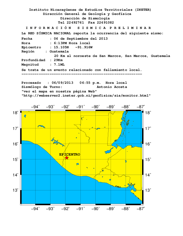
you used the Nicaraguan INETER estimate of m6.8ML
in fact they have 2 lines/events, a 6.8 and a 6.6
13/09/06 18:13:27, 14.701N, 92.419W, 15.0, 6.8ML
13/09/06 18:20:36, 13.718N, 92.270W, 15.0, 6.6ML
webserver2.ineter.gob.ni...
not sure what that's about, one may be deleted later, when I looked a couple of hours ago just the 6.6 was there, but with the time of 18:13:27
Times are local
hmm maybe not, they could be right
Retalhuleu station, Guatemala
www.iris.edu...
Mexicans have two also, but smaller magnitudes
m6.1, 2013-09-06 19:13:27, 14.25, -92.21, 66, 48 km al SUR de CD HIDALGO, CHIS
m5.4, 2013-09-06 19:20:39, 14.14, -92.0, 51, 62 km al SURESTE de CD HIDALGO, CHIS
heres an interactive map of that INETER list
goo.gl...
based on todays discussions that wouldn't quite make it into the "very-strong" category
unless ....
you used the Nicaraguan INETER estimate of m6.8ML
in fact they have 2 lines/events, a 6.8 and a 6.6
13/09/06 18:13:27, 14.701N, 92.419W, 15.0, 6.8ML
13/09/06 18:20:36, 13.718N, 92.270W, 15.0, 6.6ML
webserver2.ineter.gob.ni...
not sure what that's about, one may be deleted later, when I looked a couple of hours ago just the 6.6 was there, but with the time of 18:13:27
Times are local
edit on 7-9-2013 by muzzy because: (no reason given)
hmm maybe not, they could be right
Retalhuleu station, Guatemala
www.iris.edu...
edit on 7-9-2013 by muzzy because: (no
reason given)
Mexicans have two also, but smaller magnitudes
m6.1, 2013-09-06 19:13:27, 14.25, -92.21, 66, 48 km al SUR de CD HIDALGO, CHIS
m5.4, 2013-09-06 19:20:39, 14.14, -92.0, 51, 62 km al SURESTE de CD HIDALGO, CHIS
edit on 7-9-2013 by muzzy because: put some commas in for clarity
heres an interactive map of that INETER list
goo.gl...
edit on 7-9-2013 by muzzy because: (no reason given)
reply to post by muzzy
Yes but what if the event occurred let's say 100,000 thousand years ago,and it might repeat now.
reply to post by muzzy
Which of course in the scheme I use it was but you highlight the problem with this scale that it is based on intensity and intensity varies according to terrain. That variation however no bearing on the magnitude which is M0 and from which the Mw scale is derived and as such is pretty much a constant.
But then we come full circle. Who makes the right calculation? This really is not different from who perceives the right intensity of shaking - which of course is subjective.
At the end of the day one should use the scale of magnitude or of intensity that best fits your purpose. There is never ever going to be agreement - you only have to look at the range of magnitudes in the phase data to realise that.
I would say however that the rather more imprecise, for example, 'Major earthquake MMI VII' is probably more descriptive of the event in lay terms' as it indicates the severity of the quake at the epicentre based on it's effect on the locality rather than it's scientific force.
At the higher end, ask the Chileans what category the 8.6 of 2008 was? I bet it was a great quake in their eyes.
Which of course in the scheme I use it was but you highlight the problem with this scale that it is based on intensity and intensity varies according to terrain. That variation however no bearing on the magnitude which is M0 and from which the Mw scale is derived and as such is pretty much a constant.
But then we come full circle. Who makes the right calculation? This really is not different from who perceives the right intensity of shaking - which of course is subjective.
At the end of the day one should use the scale of magnitude or of intensity that best fits your purpose. There is never ever going to be agreement - you only have to look at the range of magnitudes in the phase data to realise that.
I would say however that the rather more imprecise, for example, 'Major earthquake MMI VII' is probably more descriptive of the event in lay terms' as it indicates the severity of the quake at the epicentre based on it's effect on the locality rather than it's scientific force.
reply to post by muzzy
I am not sure where they are getting 2 big quakes from. The main quake at 00:13 and the subsequent one at 00:20 which is shown by the three main data providers as ranging from 4.9 to 5.4 is obviously not a 6.6!
You can see this clearly on the chart you linked to which by the way was an accelerometer channel, and also on the HHZ version. On neither of these is it the same size.
This time series plot makes it a bit clearer
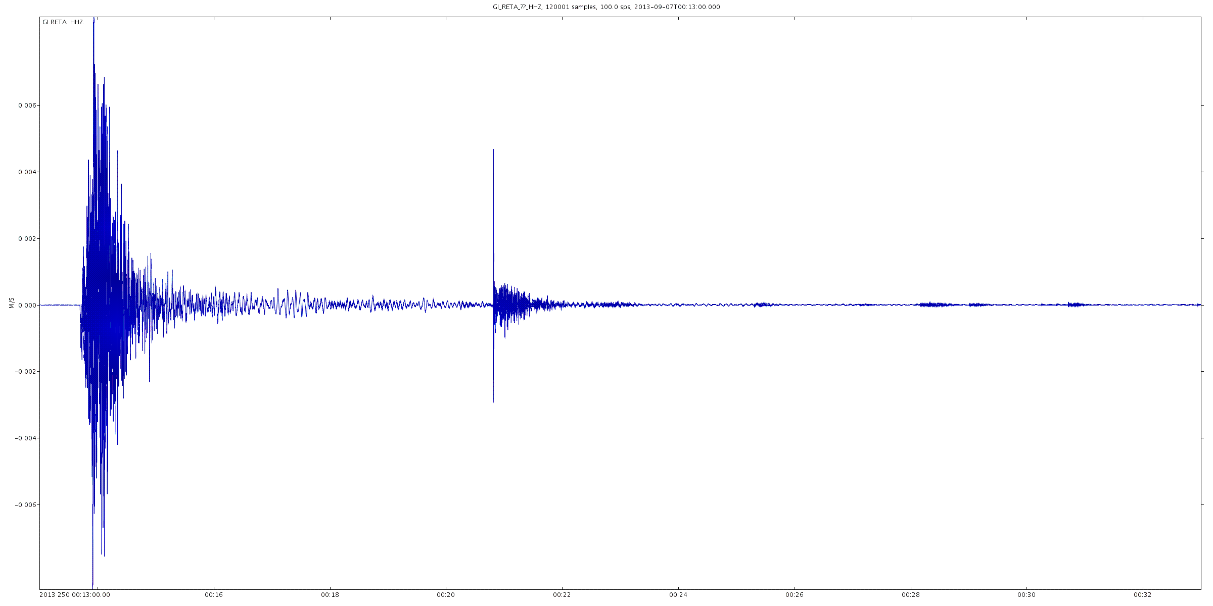
No they are not right, no maybe about it.
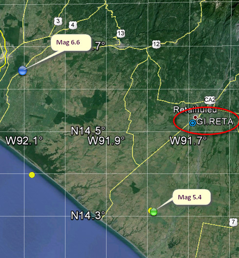
GI.RETA is ~50km from the first event and ~25km from the second event so possibly because it is closer they have it wrong but that hardly seems likely.
I note that in the text file you linked they have
If you look at the image from GE and this line from the Mag 5.4 event
2013-09-07 00:20:38, 14.309, -91.784, 5.4, 64.9, 14Km E Of Champerico. Guatemala [F] +-+07+Sep+13++00%3A20%3A38+UTC)&ll=14.30980,-91.78440& spn=2,2&f=d&t=h&hl=e][Map]
you can see that they appear to have a problem with the location of the smaller event.
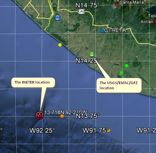
This probably explains the big difference as the software is calculating on a different location.
Yup IMHO they are wrong.
The three main providers give this data:
GFZ is useless as a location as it is only to two decimal places, but the EMSC location gives an idea of what that GFZ location was to three decimal places.
USGS is different again, but none of these match the INETER value which is 3dp, but is not even a rounded version of the USGS value which is closest to it.
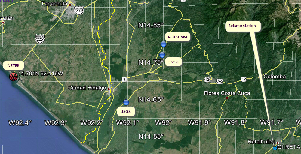
Welcome to the imprecise world of earthquake location.
I see INTER have or had 7.1 ML
I am not sure where they are getting 2 big quakes from. The main quake at 00:13 and the subsequent one at 00:20 which is shown by the three main data providers as ranging from 4.9 to 5.4 is obviously not a 6.6!
Prov,Date/Time UTC,Latitude,Longitude,Magnitude,Depth(Km),Location
gfzp,2013-09-07 00:20:38, 14.370, -91.770, 5.3, 78.0, Guatemala
usgs,2013-09-07 00:20:38, 14.309, -91.784, 5.4, 64.9, 14Km E Of Champerico. Guatemala [F]
emsc,2013-09-07 00:20:42, 14.444, -91.582, 4.9, 114.0, Guatemala
You can see this clearly on the chart you linked to which by the way was an accelerometer channel, and also on the HHZ version. On neither of these is it the same size.
This time series plot makes it a bit clearer

No they are not right, no maybe about it.
GI.RETA is ~50km from the first event and ~25km from the second event so possibly because it is closer they have it wrong but that hardly seems likely.
I note that in the text file you linked they have
13/09/06 18:13:27 14.701N 92.419W 15.0 6.8ML
13/09/06 18:20:36 13.718N 92.270W 15.0 6.6ML
If you look at the image from GE and this line from the Mag 5.4 event
2013-09-07 00:20:38, 14.309, -91.784, 5.4, 64.9, 14Km E Of Champerico. Guatemala [F] +-+07+Sep+13++00%3A20%3A38+UTC)&ll=14.30980,-91.78440& spn=2,2&f=d&t=h&hl=e][Map]
you can see that they appear to have a problem with the location of the smaller event.
This probably explains the big difference as the software is calculating on a different location.
Yup IMHO they are wrong.
The three main providers give this data:
Prov,Date/Time UTC,Latitude,Longitude,Magnitude,Depth(Km),Location
usgs,2013-09-07 00:13:29, 14.643, -92.104, 6.6, 67.0, 5Km Ese Of Ciudad Tecun Uman. Guatemala [F]
emsc,2013-09-07 00:13:30, 14.771, -92.003, 6.5, 67.0, Guatemala
gfzp,2013-09-07 00:13:32, 14.800, -92.000, 6.4, 87.0, Nr. Coast Of Chiapas. Mexico
GFZ is useless as a location as it is only to two decimal places, but the EMSC location gives an idea of what that GFZ location was to three decimal places.
USGS is different again, but none of these match the INETER value which is 3dp, but is not even a rounded version of the USGS value which is closest to it.

Welcome to the imprecise world of earthquake location.
edit on 7/9/2013 by PuterMan because: (no reason given)
I see INTER have or had 7.1 ML
edit on 7/9/2013 by PuterMan because: (no reason given)
reply to post by piequal3because14
I think the Plates are in different positions than they were 100,000 years ago, so repeat locations/occurrences probably won't apply. Especially for the "new" lands like New Zealand, Vanuatu, Solomon Is, PNG etc
maybe for China and the Middle East, but even then when was the last "major" quake in the Levant? 2050BC
Recurrence periods don't really help us much now as often these "new" m8.6+ occur in the mean time in places away from previous historic locations Sure enough earthquakes were probably occurring in the SW Pacific Arc at the same time as those in the Levant, and possibly of higher magnitudes due to volcanic activity, but no one recorded them that we know of.
I guess I should add a note in case anyone is weeing their panties about having so many quakes (if you believe the USGS lies - they say 10 in the last
6 days, the rest say 6 (GFZ) and 5(EMSC))
It has happened before. In fact it happened in November 2012 when there were 10 ratified in 9 days (which is the same as 6 in 6 days) and many others including 6 in 4 days in April 2011 not connected to Japan.
I have only gone back as far as 2011 and only visually scanned them but I am sure there are many more instances.
edit on 7/9/2013 by PuterMan because: (no reason given)
Magnitude mb 5.3
Region WESTERN TURKEY
Date time 2013-09-07 16:59:08.2 UTC
Location 39.90 N ; 27.50 E
Depth 200 km
Distances 391 km NE of Athens, Greece / pop: 729,137 / local time: 19:59:08.2 2013-09-07
43 km NW of Balıkesir, Turkey / pop: 238,151 / local time: 19:59:08.2 2013-09-07
18 km N of Balya, Turkey / pop: 1,765 / local time: 19:59:08.2 2013-09-07
EMSC
Originally posted by muzzy
reply to post by piequal3because14
Sure enough earthquakes were probably occurring in the SW Pacific Arc at the same time as those in the Levant, and possibly of higher magnitudes due to volcanic activity, but no one recorded them that we know of.
Which raises the question, what sort of earthquakes accompanied the Taupo super volcano Oruanui eruption, about 26,500 years ago, and the Taupo Hatepe Eruption, about 1,800 years ago?
Often big eruptions have a m7+ somewhere either side of them time wise, but the Oruanui eruption pretty well blew the guts out of the North Island, so I'm picking it might have had a m8+ or two around that time.
More research is required, like checking out the earthquakes recorded around the Krakatoa eruption for comparison.
Indonesia is one area I haven't looked at using Utsu's data yet.
Anybody every heard of a tsunami earthquake before?
I found this term while researching something completely unrelated. It doesn't refer to all tsunamigenic earthquakes.
These subduction zone thrust quakes are different because they have really slow rupture velocities, and long period (low frequency) waves. The surface wave magnitudes (Ms) are significantly smaller than the moment magnitudes (Mw).
Because of the abnormally small surface waves, and relatively light shaking, this type of earthquake is extremely dangerous. The following tsunami takes people by surprise.
Here are some of the causes of this particular type of thrust quake:
Further reading found modelling that shows pore pressure changes in the accretionary wedge during slow velocity ruptures can lead to extensive areas of seafloor uplift. (I think that's what this paper is saying--bits of it were way over my head, lol)
The 1992 Nicaragua earthquake was the 1st quake of this type recorded by broadband seismometers. It killed 116 people and left over 13,000 homeless.
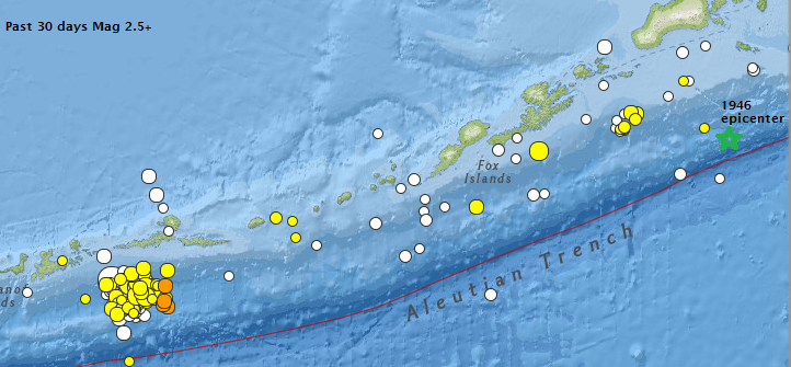
In 1946, the quake from the Aleutian Islands, Alaska had a moment mag of Mw 8.1, but the surface mag was only Ms 7.3. It generated waves up to 135 ft high, killing 6 in Alaska and 159 in Hawaii. source
The recent activity near Atka, Alaska bears watching, since it is located in the same environment as the 1946 quake. (the green star shows the 1946 epicenter, the map is set to past 30 days, mag 2.5+
USGS recent eq
After reading this info, I won't be so quick to dismiss the tsunami-generating potential of smaller subduction zone quakes, without first getting a good look at the waveform.
I found this term while researching something completely unrelated. It doesn't refer to all tsunamigenic earthquakes.
These subduction zone thrust quakes are different because they have really slow rupture velocities, and long period (low frequency) waves. The surface wave magnitudes (Ms) are significantly smaller than the moment magnitudes (Mw).
Because of the abnormally small surface waves, and relatively light shaking, this type of earthquake is extremely dangerous. The following tsunami takes people by surprise.
Here are some of the causes of this particular type of thrust quake:
Slow rupture velocities are linked to propagation through relatively weak material, such as poorly consolidated sedimentary rocks. Most tsunami earthquakes have been linked to rupture within the uppermost part of a subduction zone, where an accretionary wedge is developed in the hanging wall of the megathrust. Tsunami earthquakes have also been linked to the presence of a thin layer of subducted sedimentary rock along the uppermost part of the plate interface, as is thought to be present in areas of significant topography at the top of the oceanic crust, and where propagation was in an up-dip direction, possibly reaching the seafloor.
Further reading found modelling that shows pore pressure changes in the accretionary wedge during slow velocity ruptures can lead to extensive areas of seafloor uplift. (I think that's what this paper is saying--bits of it were way over my head, lol)
The 1992 Nicaragua earthquake was the 1st quake of this type recorded by broadband seismometers. It killed 116 people and left over 13,000 homeless.
In 1946, the quake from the Aleutian Islands, Alaska had a moment mag of Mw 8.1, but the surface mag was only Ms 7.3. It generated waves up to 135 ft high, killing 6 in Alaska and 159 in Hawaii. source
The recent activity near Atka, Alaska bears watching, since it is located in the same environment as the 1946 quake. (the green star shows the 1946 epicenter, the map is set to past 30 days, mag 2.5+
USGS recent eq
After reading this info, I won't be so quick to dismiss the tsunami-generating potential of smaller subduction zone quakes, without first getting a good look at the waveform.
edit on 9/7/2013 by Olivine because: edit
reply to post by Olivine
A trace of each as examples would be handy, to see the difference, but I can't find any off the wiki kinks.
These recent Andreanof quakes already have grandparents;
Map of them ones
A trace of each as examples would be handy, to see the difference, but I can't find any off the wiki kinks.
These recent Andreanof quakes already have grandparents;
Date/Time: 1957/3/9 14:22:32.6 UTC
Lat: 51.556 Long: -175.392
Location: USA: Andreanof Islands coast, Aleutians, Alaska
Magnitude: 9.1 M
Depth: 30 km
Date/Time: 1986/5/7 1:47:- -
Lat: 51.52 Long: -174.776
Location: USA:Andreanof Islands, Aleutian Islands, Alaska
Magnitude: 8 M
Source: National Earthquake Information Centre, United States Geological Survey
Map of them ones
reply to post by muzzy
Here is one Muzzy. This image compares the Nicaraguan quake (top waveform), with the 1992 Landers quake below. Take note of the time scale at the bottom.
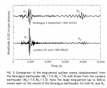
This image and one other can be seen in Kanamori's paper published in the journal Nature, 25 February 1993, and at the Caltech link above.
The magnitudes given in this paper are different than the magnitudes I listed above. I believe they have been revised several times through the years.
I wonder if this type of quake is possible on the Cascadia subduction zone? It certainly has plenty of sediments in the trench, some of which could have already made there way into the plate interface via previous quakes over the millennia.
BTW Muzzy, I notice an avatar change. Is that from a chrome page not loading, or the ATS 5.3 smiley collection?
Here is one Muzzy. This image compares the Nicaraguan quake (top waveform), with the 1992 Landers quake below. Take note of the time scale at the bottom.
This image and one other can be seen in Kanamori's paper published in the journal Nature, 25 February 1993, and at the Caltech link above.
The magnitudes given in this paper are different than the magnitudes I listed above. I believe they have been revised several times through the years.
I wonder if this type of quake is possible on the Cascadia subduction zone? It certainly has plenty of sediments in the trench, some of which could have already made there way into the plate interface via previous quakes over the millennia.
BTW Muzzy, I notice an avatar change. Is that from a chrome page not loading, or the ATS 5.3 smiley collection?
edit on 9/7/2013 by Olivine
because: add a thought
edit on 9/7/2013 by Olivine because: (no reason given)
reply to post by muzzy
Plates are certainly in different positions,but not with big differences,so we do not know if they behave the same way as 100,000 years ago,or
how they behaved.
new topics
-
God's Righteousness is Greater than Our Wrath
Religion, Faith, And Theology: 45 minutes ago -
Electrical tricks for saving money
Education and Media: 3 hours ago -
VP's Secret Service agent brawls with other agents at Andrews
Mainstream News: 5 hours ago -
Sunak spinning the sickness figures
Other Current Events: 5 hours ago -
Nearly 70% Of Americans Want Talks To End War In Ukraine
Political Issues: 6 hours ago -
Late Night with the Devil - a really good unusual modern horror film.
Movies: 7 hours ago -
Cats Used as Live Bait to Train Ferocious Pitbulls in Illegal NYC Dogfighting
Social Issues and Civil Unrest: 9 hours ago -
The Good News According to Jesus - Episode 1
Religion, Faith, And Theology: 11 hours ago
top topics
-
Florida man's trip overseas ends in shock over $143,000 T-Mobile phone bill
Social Issues and Civil Unrest: 16 hours ago, 8 flags -
Cats Used as Live Bait to Train Ferocious Pitbulls in Illegal NYC Dogfighting
Social Issues and Civil Unrest: 9 hours ago, 8 flags -
VP's Secret Service agent brawls with other agents at Andrews
Mainstream News: 5 hours ago, 8 flags -
Bobiverse
Fantasy & Science Fiction: 16 hours ago, 3 flags -
HORRIBLE !! Russian Soldier Drinking Own Urine To Survive In Battle
World War Three: 13 hours ago, 3 flags -
Electrical tricks for saving money
Education and Media: 3 hours ago, 3 flags -
Nearly 70% Of Americans Want Talks To End War In Ukraine
Political Issues: 6 hours ago, 3 flags -
Sunak spinning the sickness figures
Other Current Events: 5 hours ago, 3 flags -
Late Night with the Devil - a really good unusual modern horror film.
Movies: 7 hours ago, 2 flags -
The Good News According to Jesus - Episode 1
Religion, Faith, And Theology: 11 hours ago, 1 flags
active topics
-
VP's Secret Service agent brawls with other agents at Andrews
Mainstream News • 34 • : WeMustCare -
New whistleblower Jason Sands speaks on Twitter Spaces last night.
Aliens and UFOs • 53 • : pianopraze -
Sunak spinning the sickness figures
Other Current Events • 5 • : glen200376 -
SETI chief says US has no evidence for alien technology. 'And we never have'
Aliens and UFOs • 44 • : MikeDeGrasseTyson -
HORRIBLE !! Russian Soldier Drinking Own Urine To Survive In Battle
World War Three • 31 • : budzprime69 -
How ageing is" immune deficiency"
Medical Issues & Conspiracies • 33 • : rickymouse -
The Reality of the Laser
Military Projects • 46 • : Zaphod58 -
God's Righteousness is Greater than Our Wrath
Religion, Faith, And Theology • 0 • : randomuser2034 -
President BIDEN Vows to Make Americans Pay More Federal Taxes in 2025 - Political Suicide.
2024 Elections • 136 • : ImagoDei -
Electrical tricks for saving money
Education and Media • 3 • : Mike72