It looks like you're using an Ad Blocker.
Please white-list or disable AboveTopSecret.com in your ad-blocking tool.
Thank you.
Some features of ATS will be disabled while you continue to use an ad-blocker.

Quake Watch 2013
page: 138share:
reply to post by crappiekat
Well thank you so much! You made my day! I remember you as well and glad to hear from you again. This should be all I need....I just had a question to ask him, though he probably won't answer LOL.....thanks again hon....
Well thank you so much! You made my day! I remember you as well and glad to hear from you again. This should be all I need....I just had a question to ask him, though he probably won't answer LOL.....thanks again hon....
reply to post by Anmarie96
Hi Anmarie! Yes that's him......good to be back...and good to see you here still!
Hi Anmarie! Yes that's him......good to be back...and good to see you here still!
reply to post by chiefsmom
Well I can't say I am a professional, nor can i say that I am nervous. As a serious amateur it seems to me that the current activity is not out of the ordinary.
That should be good for invoking an 8.5!
Is it just me, or are you "professionals" getting nervous about what is going on right now?
Well I can't say I am a professional, nor can i say that I am nervous. As a serious amateur it seems to me that the current activity is not out of the ordinary.
That should be good for invoking an 8.5!
reply to post by crappiekat
No they did not drop it. Someone there committed the cardinal sin of altering the URL after the page had been posted. They made it /08/ instead of /8/
Here is the new link
No they did not drop it. Someone there committed the cardinal sin of altering the URL after the page had been posted. They made it /08/ instead of /8/
Here is the new link
The Alaska quakes are quite interesting. Not sure if this is a lull and they will continue but there have been no quakes recorded since 11:14am UTC on
the 4th and the last 3 between 10am and 11:14 were in a different area. Mapping the latitudes and longitudes it is easy to see the ones that were in
the same place. These are all connected to the mag 7. Click the images for larger versions.
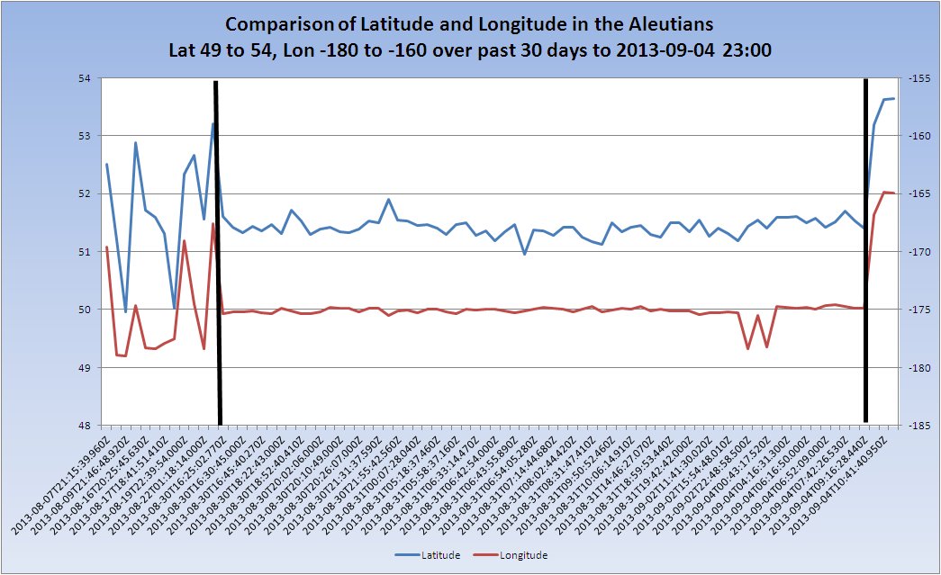
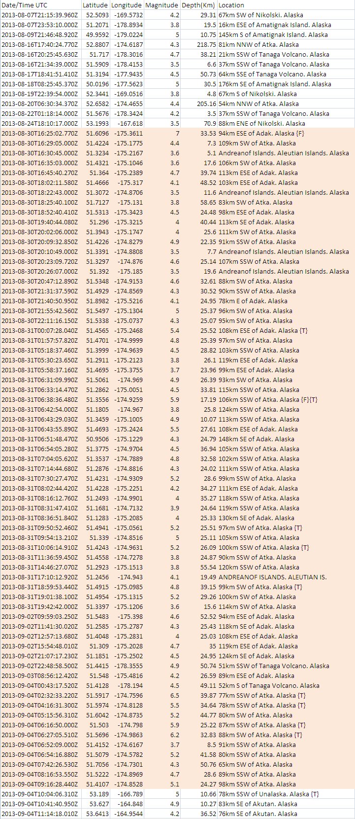
The data associated with that (marked in orange) is thus:
The other side of the IDL the sequence is shorter, between 14th and 18th August and is probably not connected.
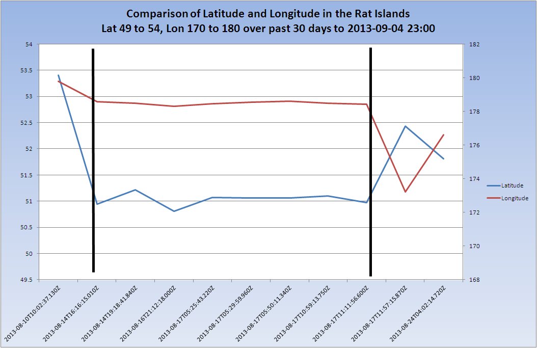
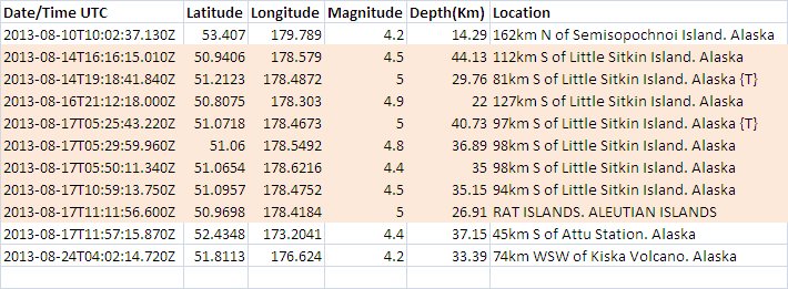
The data associated with that is thus:
Tomorrow should be interesting to see if it continues westward or returns to the current patch.

The data associated with that (marked in orange) is thus:

The other side of the IDL the sequence is shorter, between 14th and 18th August and is probably not connected.

The data associated with that is thus:

Tomorrow should be interesting to see if it continues westward or returns to the current patch.
Originally posted by PuterMan
The Alaska quakes are quite interesting. Not sure if this is a lull and they will continue but there have been no quakes recorded since 11:14am UTC on the 4th and the last 3 between 10am and 11:14 were in a different area. Mapping the latitudes and longitudes it is easy to see the ones that were in the same place. These are all connected to the mag 7. Click the images for larger versions.
The data associated with that (marked in orange) is thus:
The other side of the IDL the sequence is shorter, between 14th and 18th August and is probably not connected.
The data associated with that is thus:
Tomorrow should be interesting to see if it continues westward or returns to the current patch.
DUDE........!!
I love your posts!
I appreciate all the work you put into your graphs
M 6.0 - Northern Mid-Atlantic Ridge
Time
2013-09-04 23:01:35 UTC-05:00
Location
15.209°N 45.167°W
Depth
10.0km
berkeleygal, now living in Marion Ilinois, in the Wabash Seismic Zone
Time
2013-09-04 23:01:35 UTC-05:00
Location
15.209°N 45.167°W
Depth
10.0km
berkeleygal, now living in Marion Ilinois, in the Wabash Seismic Zone
Is it just me or does it seem a large majority of the recent quakes have occured at very shallow depths.
I notice a large amount of eq's at around 10km deep - a lot of the bigger quakes.
Also many in the 10km to 100km range.
The Japan quakes seem to be much deeperr but I noticed yesterday that a lot of yesterday's quakes were around 10km deep - now this 6.0 on the Mid-AtlanticRidge is also 10km deep.
I know nothing - I am just posting some observations.
Anyone with insight that can make anything of this - please advise.
Thanks.
edit on 9/5/2013 by csulli456 because: spelling
reply to post by csulli456
Someone will come and correct me if I'm wrong - but I'm pretty sure 10km is usually the depth when the quake is registered automatically.
Someone will come and correct me if I'm wrong - but I'm pretty sure 10km is usually the depth when the quake is registered automatically.
Originally posted by chiefsmom
Is it just me, or are you "professionals" getting nervous about what is going on right now?
Niether a professional or nervous.
Here's a "funny" one
earthquake.usgs.gov...
Nid
reply to post by radpetey
Thank you
Not 10 minutes after I posted that there was another in the area and three so far today.
I do find it quite odd how it came to an abrupt stop. It does seem to be a feature of the area.
The three at latitude ~53+ have not got any follow on quakes at present.
Thank you
Not 10 minutes after I posted that there was another in the area and three so far today.
Prov,Date/Time UTC,Latitude,Longitude,Magnitude,Depth(Km),Location
usgs,2013-09-04 09:16:28, 51.410, -174.852, 5.1, 24.2, 98Km Ssw Of Atka. Alaska
--- the gap ----
usgs,2013-09-04 23:54:02, 51.429, -174.590, 4.8, 27.2, 89Km Ssw Of Atka. Alaska
usgs,2013-09-05 05:43:40, 51.462, -174.554, 5.6, 24.2, 85Km Ssw Of Atka. Alaska [F][T]
usgs,2013-09-05 06:38:57, 51.665, -174.973, 4.5, 19.9, 79Km Sw Of Atka. Alaska
usgs,2013-09-05 07:44:06, 51.453, -174.687, 4.9, 26.8, 89Km Ssw Of Atka. Alaska
I do find it quite odd how it came to an abrupt stop. It does seem to be a feature of the area.
The three at latitude ~53+ have not got any follow on quakes at present.
edit on 5/9/2013 by PuterMan because: rats!! well spelling actually!
reply to post by bkaust
There are a number of 'automatic depths' where the depth is not well constrained so yes you are correct. Other depths are 5 and 33 for USGS. Which one gets used depends on the area of the quakes. Some providers also use 2km as well.
Source: USGS Glossary of Terms
I'm pretty sure 10km is usually the depth when the quake is registered automatically.
There are a number of 'automatic depths' where the depth is not well constrained so yes you are correct. Other depths are 5 and 33 for USGS. Which one gets used depends on the area of the quakes. Some providers also use 2km as well.
For example, 33 km is often used as a default depth for earthquakes determined to be shallow, but whose depth is not satisfactorily determined by the data, whereas default depths of 5 or 10 km are often used in mid-continental areas and on mid-ocean ridges since earthquakes in these areas are usually shallower than 33 km.
Source: USGS Glossary of Terms
reply to post by Nidwin
At 163km depth thankfully it is most likely not associated with the Toba dome but with the subduction zone. Had that been a shallow quake it would not have been funny at all, but OMG run for the hills or if one is British - "I say old chap that was a trifle worrying."
Here's a "funny" one
At 163km depth thankfully it is most likely not associated with the Toba dome but with the subduction zone. Had that been a shallow quake it would not have been funny at all, but OMG run for the hills or if one is British - "I say old chap that was a trifle worrying."
reply to post by csulli456
Expanding bkaust's reply a little:
Source: Well worth a visit as it has interactive buttons for the depth distributions
In fact the whole of that "How Are Earthquakes Related to Plate Tectonics?" from page 1 is worth a look if you are learning about earthquakes. My only criticism of it would be that it asks too many questions that it then fails to answer, but the maps are good.
The Wikipedia page Earthquake is well worth a (long) read and this PDF file Earthquakes is also worth downloading and reading
Contents of 'Earthquakes'
You will find these links and many more on the subject of seismograms and earthquakes here: Understanding Seismograms and Earthquakes
It is not so easy to get actual figure for how many occur in each of those bands. My own database of published USGS data from the start of 2009 gives the following figures:
Total number of quakes 604,340 (Percentages are rounded) In view of the span of the database this is probably a reasonable estimation of the percentages, even if skewed in favour of North America on the smaller quakes.
EMSC gives different percentage as they only record Mag 2+ in Europe and Mag 4+ elsewhere
Total: 102,657
Expanding bkaust's reply a little:
The focus of an earthquake is the actual point underground where rocks break. The depth of the focus can be categorized as shallow (up to 70 km below the surface), intermediate (70 to 300 km), or deep (greater than 300 km).
Source: Well worth a visit as it has interactive buttons for the depth distributions
In fact the whole of that "How Are Earthquakes Related to Plate Tectonics?" from page 1 is worth a look if you are learning about earthquakes. My only criticism of it would be that it asks too many questions that it then fails to answer, but the maps are good.
The Wikipedia page Earthquake is well worth a (long) read and this PDF file Earthquakes is also worth downloading and reading
Contents of 'Earthquakes'
- Introduction
- Faults & Earthquakes
- Seismic Waves
- Effects Of Earthquakes
- Measurement of Earthquakes
- Distribution Of Earthquakes
- Earthquake Prediction
- Summary
You will find these links and many more on the subject of seismograms and earthquakes here: Understanding Seismograms and Earthquakes
It is not so easy to get actual figure for how many occur in each of those bands. My own database of published USGS data from the start of 2009 gives the following figures:
- Depth 0 to 70 = 571 400 (94.5%)
- Depth >70 to 300 = 31,629 (5.2%)
- Depth > 300 = 1,311 (0.2%)
Total number of quakes 604,340 (Percentages are rounded) In view of the span of the database this is probably a reasonable estimation of the percentages, even if skewed in favour of North America on the smaller quakes.
EMSC gives different percentage as they only record Mag 2+ in Europe and Mag 4+ elsewhere
Total: 102,657
- Depth 0 to 70 = 93,093 (90.7%)
- Depth >70 to 300 = 8,461 (8.2%)
- Depth > 300 = 1,103 (1.1%)
Mid-Atlantic ridge is very active again. Look this:
How about Iceland?


Something tells me this activity is still continuing. I expect quakes between Mid-Atlantic Ridge and Reykjanes Ridge, maybe something in Jan Mayen. That Costa Rica earthquake is bit far from Mid-Atlantic, but its connected. But where are the Canary Islands quakes?
If you watch southern part of Iceland, you must notice that there is 2 swarms close to each other, they are volcanoes: Katla and Torfajökull. We know Katla has been restless for some time already (It maybe have even erupted in summer 2012), but Torfajökull... That volcano has been sleeping since 1477, it hasn't erupted since then. Its biggest rhyolite-volcano in Iceland. We do not know much about this volcano, it may have large gas content which could cause ash chaos.
Type: EarthQuake
8 hours ago
Magnitude: 5.9
DateTime: 2013-09-04 23:01:36
Region: Northern Mid-atlantic Ridge
Depth: 10
Source: CSEM-EMSC Feed
Type: EarthQuake
18 minutes ago
Magnitude: 6
DateTime: 2013-09-05 07:29:18
Region: off the coast of Costa Rica
Depth: 41.7
Source: USGS Feed
How about Iceland?
Something tells me this activity is still continuing. I expect quakes between Mid-Atlantic Ridge and Reykjanes Ridge, maybe something in Jan Mayen. That Costa Rica earthquake is bit far from Mid-Atlantic, but its connected. But where are the Canary Islands quakes?
If you watch southern part of Iceland, you must notice that there is 2 swarms close to each other, they are volcanoes: Katla and Torfajökull. We know Katla has been restless for some time already (It maybe have even erupted in summer 2012), but Torfajökull... That volcano has been sleeping since 1477, it hasn't erupted since then. Its biggest rhyolite-volcano in Iceland. We do not know much about this volcano, it may have large gas content which could cause ash chaos.
edit on 5-9-2013 by Thebel because: (no reason given)
Speaking of Iceland, isn't that where the volcano with the weird and unpronounceable name went off and disrupted air traffic for weeks? And didn't
they tell us that there was an underground lava tube connection between it and it's sister volcano, Katla, and that historically Katla erupted within
5 years of the unpronounceable one but much worse? We have to be coming up on 2 to 3 years now. I wonder if Katla will blow like they said it would.
That would give us a volcanic summer and ruin crops over a large part of the world. In fact, from what I remember hearing, Katla would make the Mt
Pinatubo eruption in the Philippines back in the 80's, that gave us some of the most beautiful sunsets I have ever seen, look like a firecracker next
to a case of dynamite.
reply to post by happykat39
There's no clear or scientific evidence that Katla will erupt between 2 and 5 Years after an eruption at Eyja. It happened 2 times in the past, if I remember well, but Eyja also erupted without having Katla blowing her top off afterwards.
Torfa would be more annoying than Katla but even with those 2 volcanos you can't say how devastating it's going to be. Bigger volcanos, compared to Eyja, can produce bigger eurptions but they can still produce just a small one too.
Originally posted by happykat39
Speaking of Iceland, isn't that where the volcano with the weird and unpronounceable name went off and disrupted air traffic for weeks? And didn't they tell us that there was an underground lava tube connection between it and it's sister volcano, Katla, and that historically Katla erupted within 5 years of the unpronounceable one but much worse? We have to be coming up on 2 to 3 years now. I wonder if Katla will blow like they said it would. That would give us a volcanic summer and ruin crops over a large part of the world. In fact, from what I remember hearing, Katla would make the Mt Pinatubo eruption in the Philippines back in the 80's, that gave us some of the most beautiful sunsets I have ever seen, look like a firecracker next to a case of dynamite.
It was unnamed volcano (you read it right) which is under Eyjafjallajökull glacier. Katla infact erupted after it, but it was too small to break the ice, there was small glacier flood though. It's eruption would be much more devastating compared to Eyjafjallajökull eruption. There is no signs Katla would erupt soon.
But I don't know much about this Torfajökull. Its north of Katla, and seemingly has larger caldera. I have watched the activity of Iceland after Eyjafjallajökull eruption, and I can say its rare that Torfajökull has swarms, it has always been very calm. There is some hot springs and such, but no quakes.
The area looks like this right now (Those black triangles are not volcanoes! They are observing stations). Katla is under Mýrdalsjökull.

edit on 5-9-2013 by Thebel because: (no reason given)
new topics
-
President BIDEN Vows to Make Americans Pay More Federal Taxes in 2025 - Political Suicide.
2024 Elections: 2 hours ago -
Ode to Artemis
General Chit Chat: 2 hours ago -
Ditching physical money
History: 6 hours ago -
One Flame Throwing Robot Dog for Christmas Please!
Weaponry: 6 hours ago -
Don't take advantage of people just because it seems easy it will backfire
Rant: 6 hours ago -
VirginOfGrand says hello
Introductions: 7 hours ago -
Should Biden Replace Harris With AOC On the 2024 Democrat Ticket?
2024 Elections: 8 hours ago -
University student disciplined after saying veganism is wrong and gender fluidity is stupid
Education and Media: 10 hours ago -
Geddy Lee in Conversation with Alex Lifeson - My Effin’ Life
People: 11 hours ago
top topics
-
Hate makes for strange bedfellows
US Political Madness: 16 hours ago, 20 flags -
University student disciplined after saying veganism is wrong and gender fluidity is stupid
Education and Media: 10 hours ago, 12 flags -
Police clash with St George’s Day protesters at central London rally
Social Issues and Civil Unrest: 13 hours ago, 9 flags -
President BIDEN Vows to Make Americans Pay More Federal Taxes in 2025 - Political Suicide.
2024 Elections: 2 hours ago, 7 flags -
TLDR post about ATS and why I love it and hope we all stay together somewhere
General Chit Chat: 14 hours ago, 7 flags -
Should Biden Replace Harris With AOC On the 2024 Democrat Ticket?
2024 Elections: 8 hours ago, 6 flags -
Don't take advantage of people just because it seems easy it will backfire
Rant: 6 hours ago, 4 flags -
One Flame Throwing Robot Dog for Christmas Please!
Weaponry: 6 hours ago, 4 flags -
God lived as a Devil Dog.
Short Stories: 12 hours ago, 3 flags -
Ditching physical money
History: 6 hours ago, 3 flags
active topics
-
British TV Presenter Refuses To Use Guest's Preferred Pronouns
Education and Media • 126 • : Asher47 -
Why to avoid TikTok
Education and Media • 17 • : mooncake -
The Superstition of Full Moons Filling Hospitals Turns Out To Be True!
Medical Issues & Conspiracies • 22 • : mooncake -
University student disciplined after saying veganism is wrong and gender fluidity is stupid
Education and Media • 23 • : BigDuckEnergy -
President BIDEN Vows to Make Americans Pay More Federal Taxes in 2025 - Political Suicide.
2024 Elections • 3 • : BingoMcGoof -
Russia Ukraine Update Thread - part 3
World War Three • 5717 • : Arbitrageur -
Should Biden Replace Harris With AOC On the 2024 Democrat Ticket?
2024 Elections • 44 • : budzprime69 -
Hundreds of teenagers flood into downtown Chicago, smashing car windows
Other Current Events • 111 • : 777Vader -
Who guards the guards
US Political Madness • 4 • : kwaka -
New whistleblower Jason Sands speaks on Twitter Spaces last night.
Aliens and UFOs • 44 • : pianopraze