It looks like you're using an Ad Blocker.
Please white-list or disable AboveTopSecret.com in your ad-blocking tool.
Thank you.
Some features of ATS will be disabled while you continue to use an ad-blocker.

Quake Watch 2013
page: 122share:
reply to post by crappiekat
Usgs has blind spots and this is one.
I use this one for quick info
quakes.globalincidentmap.com...#
This one for confirmation on some quakes
earthquake.usgs.gov...
And this one for the actual size and the ones missed
www.emsc-csem.org...
Also info on are Magnetosphere
ccmc.gsfc.nasa.gov...
Usgs has blind spots and this is one.
I use this one for quick info
quakes.globalincidentmap.com...#
This one for confirmation on some quakes
earthquake.usgs.gov...
And this one for the actual size and the ones missed
www.emsc-csem.org...
Also info on are Magnetosphere
ccmc.gsfc.nasa.gov...
edit on 7/30/2012 by dreamfox1 because: (no reason given)
Is it normal to have that many small quakes in such a short time across such a broad area?
Originally posted by Thorneblood
Is it normal to have that many small quakes in such a short time across such a broad area?
It happens when there are big quakes happening and also what worry's me when great quakes want to occur
reply to post by crappiekat
Because its probably an error.
I had a look on the Marianas Is and Japan IRIS seismos which are closest and there is nothing there.
also if you go to the source on EMSC you find its ZAMG, Austria, I went there and its not showing either
For situations like this I use www.oe-files.de... which uses RSS Feeds off EMSC, Geofon and Useless ......................, nothing there so it must be filtered for errors
The EMSC does however have it on their RSS Feed page www.emsc-csem.org...
ha! now its on oe-files but only under EMSC (unclick the "follow" box when you screen over to the spot for the other networks)
quite a handy tool, but apart from Useless the timeline is only 24hrs (see the bar)
the real truth is on the LISS - Live Internet Seismic Server, a 6.6 would/should be all over at least a few of the graphs on the 5:00 line by now
Because its probably an error.
I had a look on the Marianas Is and Japan IRIS seismos which are closest and there is nothing there.
also if you go to the source on EMSC you find its ZAMG, Austria, I went there and its not showing either
For situations like this I use www.oe-files.de... which uses RSS Feeds off EMSC, Geofon and Useless ......................, nothing there so it must be filtered for errors
The EMSC does however have it on their RSS Feed page www.emsc-csem.org...
edit on 12-8-2013 by muzzy
because: (no reason given)
ha! now its on oe-files but only under EMSC (unclick the "follow" box when you screen over to the spot for the other networks)
quite a handy tool, but apart from Useless the timeline is only 24hrs (see the bar)
edit on 12-8-2013 by muzzy because: (no reason
given)
the real truth is on the LISS - Live Internet Seismic Server, a 6.6 would/should be all over at least a few of the graphs on the 5:00 line by now
edit on 12-8-2013 by muzzy because: (no reason given)
reply to post by muzzy
The SHZ channels at Yellowstone are not on the public feed. They all come from UoU.
LKWY is the only satellite station in the Park I believe, the rest being broadband connections.
Looks pretty much the same to me. Don't forget IRIS show a UTC day and UoU confuse the issue by showing 24 hours from now in UTC and the other weird times these folks elsewhere use. All earthquake data should be in UTC only irrespective of where the reporting system is based in my opinion.
The SHZ channels at Yellowstone are not on the public feed. They all come from UoU.
LKWY is the only satellite station in the Park I believe, the rest being broadband connections.
how come this one of the same time period looks different
Looks pretty much the same to me. Don't forget IRIS show a UTC day and UoU confuse the issue by showing 24 hours from now in UTC and the other weird times these folks elsewhere use. All earthquake data should be in UTC only irrespective of where the reporting system is based in my opinion.
edit on 12/8/2013 by PuterMan because: (no reason given)
reply to post by muzzy
Which is mostly USGS
USGS have been given the heave ho, replaced with ANSS system
Which is mostly USGS
reply to post by muzzy
You are right, but all the links provided recently show a large number of smaller 1.0+ to 6.0 + quakes all over the Pacific Rim i the past five hours, hence why i asked.
You are right, but all the links provided recently show a large number of smaller 1.0+ to 6.0 + quakes all over the Pacific Rim i the past five hours, hence why i asked.
edit on 12-8-2013 by Thorneblood because: (no reason given)
Originally posted by radpetey
Originally posted by ressiv
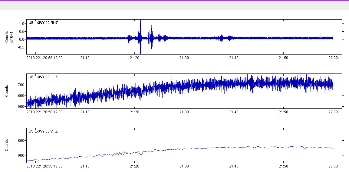
nice seismo of lake yellowstone
www.isthisthingon.org...
Sure looks harmonic.....However, I can not hear it!
Puterman will know!
Well he might, but then again he might not!
This is a small section of three sensors on the Z channel.
(click to enlarge)
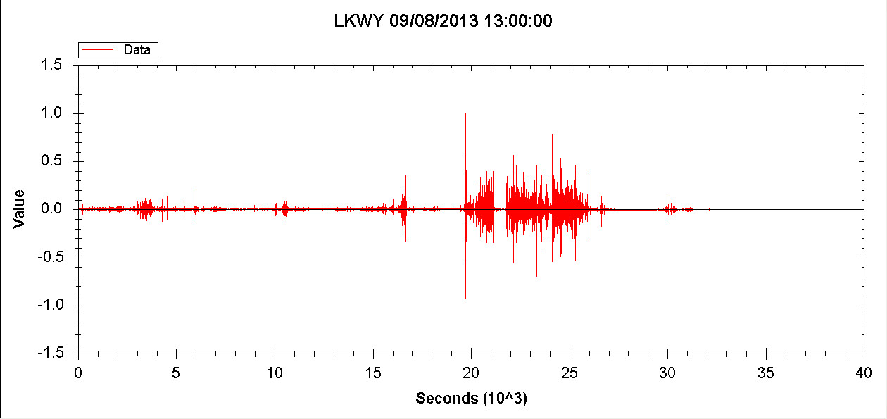
This is the BHZ channel loaded into QVSData and it is not looking harmonic to me.
(click to enlarge)
An finally this is the spectrogram of the signal above, and that is not harmonic or seismic as in earthquake related..
(click to enlarge)
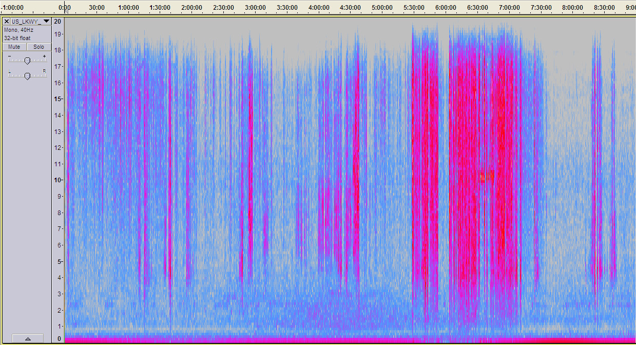
I don't see anything in particular on the K indices that would indicate a solar source but it sounds quite like that, with a short burst of what may be the heaters. My guess is some sort of signal interference during transmission. Definitely not earthquake or volcanic related.
reply to post by muzzy
Thank you Muzzy.
I kinda had a feeling that this was the case.
So as an ATSer, I have come to wonder other things, when something doesn't make sense.
I just find it interesting.
Thank you Muzzy.
I kinda had a feeling that this was the case.
So as an ATSer, I have come to wonder other things, when something doesn't make sense.
I just find it interesting.
edit on 12-8-2013 by crappiekat because: (no reason given)
reply to post by dreamfox1
Well not exactly. USGS records all quakes in US territory and quakes elsewhere of Mag 4.5 (they say), but generally Mag 5. Of course this will depend on whether their software determines the quake to be a mag 5 and as we know they have a discount system.
EMSC in similar fashion records earthquakes above 2.0 in Oorop but Mag 4 else where in places like Amerikay. Oorop extends to South America - we annexed it - and very soon Chile and Argentina will be in the European Union, as will Russia if the Ooropeen dictators get their way.
Outside Oorop they record Mag 4 thus not much in Amerikay gets recorded.
ANSS gets data from various sources, but mainly they only deal with earthquakes from the American systems
This is the list of sources going into the ANSS networks (but see below)
As you can see it encompasses all of the USGS data (NEIC) and various other American networks. It is constrained as a result by the same parameters as the USGS in effect.
In addition however there is a vast number of codes used for other magnitude data. One should read the information about ANSS before considering it a global source. It is after all the Advanced National Seismic System - National being USA.
The data going into IRIS is a different matter as that is the seismic data from many centres around the world and aside from it's own seismic monitor which has parameters as USGS I believe, it does not record earthquakes as such, only seismic data. Even IRIS however whilst holding global data is a US centric organisation. The equivalent of IRIS in Oopop is Orpheus. Orpheus is of course Europe centric
Organisations such as GeoNet, GeoScience and others feed data to IRIS but that data is not used to record quakes at IRIS. Truly global networks such as G, II or IU cover most of the globe except the Southern Hemisphere which is not part of the globe as that is mainly water and folks with hooked toes and is of little interest to Amerikay or Oorop. Other networks call themselves 'Global', such as GT, but are not and are only interested in places where there be minerals.or places of strategic benefit.
So in reality USGS does not actually have any different blind spots to anyone else amongst the main players. It is a matter of what they choose to use for their purposes and the same applies to EMSC and GFZ.
One cannot depend for all information of one single source of data, In many cases with European data you will have to go to the local provider to get details of events below Mag 2, but that is hardly surprising since as yet we are a bunch of distinct countries and long may be remain so. The USGS covers on it's own networks an area that in effect is one country and this gives advantages but note however that even in the US you need to go to local sources for some data - Oklahoma for example.
Understandably most of these organisations are primarily interested in how quakes affect their particular areas.
Usgs has blind spots and this is one.
Well not exactly. USGS records all quakes in US territory and quakes elsewhere of Mag 4.5 (they say), but generally Mag 5. Of course this will depend on whether their software determines the quake to be a mag 5 and as we know they have a discount system.
EMSC in similar fashion records earthquakes above 2.0 in Oorop but Mag 4 else where in places like Amerikay. Oorop extends to South America - we annexed it - and very soon Chile and Argentina will be in the European Union, as will Russia if the Ooropeen dictators get their way.
Outside Oorop they record Mag 4 thus not much in Amerikay gets recorded.
ANSS gets data from various sources, but mainly they only deal with earthquakes from the American systems
This is the list of sources going into the ANSS networks (but see below)
Network Codes for ANSS Networks
Code Network Name and Operator
AK Alaska Regional Network (Univ. of Alaska, USGS)
BK Berkeley Seismic Network (UC Berkeley)
CI Southern California Seismic Network (Caltech, USGS)
DR Dominican Republic Seismic Network (Instituto Sismologico Universitario)
HV Hawaii Volcano Observatory Network (USGS)
LD Lamont Doherty Seismographic Network
MB Montana Seismic Network
NC Northern California Seismic Networks (USGS, UC Berkeley)
NE New England Seismic Network (Boston College)
NM Cooperative New Madrid Seismic Network (St. Louis Univ, Univ. of Memphis, USGS)
NN Nevada Seismic Network (Univ. of Nevada, Reno)
PR Puerto Rico Seismic Network (Univ of Puerto Rico, Mayaguez)
SE SouthEast US Network
US National Earthquake Information Center (NEIC) (USGS)
UU Utah Seismic Network (Univ. of Utah)
UW Pacific Northwest Seismic Network
(Univ. of Washington, Univ. of Oregon, Oregon State Univ.)
WY Yellowstone WY Seismic Network (USGS, Univ. of Utah)
As you can see it encompasses all of the USGS data (NEIC) and various other American networks. It is constrained as a result by the same parameters as the USGS in effect.
In addition however there is a vast number of codes used for other magnitude data. One should read the information about ANSS before considering it a global source. It is after all the Advanced National Seismic System - National being USA.
The data going into IRIS is a different matter as that is the seismic data from many centres around the world and aside from it's own seismic monitor which has parameters as USGS I believe, it does not record earthquakes as such, only seismic data. Even IRIS however whilst holding global data is a US centric organisation. The equivalent of IRIS in Oopop is Orpheus. Orpheus is of course Europe centric
Organisations such as GeoNet, GeoScience and others feed data to IRIS but that data is not used to record quakes at IRIS. Truly global networks such as G, II or IU cover most of the globe except the Southern Hemisphere which is not part of the globe as that is mainly water and folks with hooked toes and is of little interest to Amerikay or Oorop. Other networks call themselves 'Global', such as GT, but are not and are only interested in places where there be minerals.or places of strategic benefit.
So in reality USGS does not actually have any different blind spots to anyone else amongst the main players. It is a matter of what they choose to use for their purposes and the same applies to EMSC and GFZ.
One cannot depend for all information of one single source of data, In many cases with European data you will have to go to the local provider to get details of events below Mag 2, but that is hardly surprising since as yet we are a bunch of distinct countries and long may be remain so. The USGS covers on it's own networks an area that in effect is one country and this gives advantages but note however that even in the US you need to go to local sources for some data - Oklahoma for example.
Understandably most of these organisations are primarily interested in how quakes affect their particular areas.
reply to post by muzzy
No, probably just a slow feed.
The seismologists have rolled into work (now 10:40 in Europe) had their breakfast coffee and croissants and are ready for tackle the day:
One earthquake gone. That's it chaps. Time for lunch and a siesta.
For situations like this I use www.oe-files.de... which uses RSS Feeds off EMSC, Geofon and Useless ......................, nothing there so it must be filtered for errors
No, probably just a slow feed.
The seismologists have rolled into work (now 10:40 in Europe) had their breakfast coffee and croissants and are ready for tackle the day:
One earthquake gone. That's it chaps. Time for lunch and a siesta.
edit on 12/8/2013 by PuterMan because: (no reason given)
Magnitude 6.2 - *Near Coast Of Northern Peru [F]
+-+12+Aug+13++09%3A49%3A33+UTC)&ll=-5.40930,-81.90870&spn=2,2& f=d&t=h&hl=e]Location in Google Maps
- Date-Time: Monday, August 12, 2013 @ 09:49:33 UTC
- Earthquake location: 5.409°S, 81.909°W,
- Earthquake depth: 16.7 km
- Distances:
94km (58mi) WSW of Paita, Peru
102km (63mi) WSW of Salinera Colan, Peru
115km (71mi) SW of Talara, Peru
121km (75mi) W of Sechura, Peru
685km (425mi) SSW of Quito, Ecuador
- Event ID: usb000j10u
Derived from Event Data Source: USGS
Powered by QVSData
edit on 12/8/2013 by PuterMan because: To change title to something understandable
* One of the inconsistencies of the FE regions. Whilst for the most part 'near' the coast means on land, and 'off' the coast means in the sea, in this case 'near' the coast is in the sea!
edit on 12/8/2013 by PuterMan because: (no reason given)
reply to post by Hellas
I guess it is just doing a bit of catching up. It has been rather a long time since the last ones.
I guess it is just doing a bit of catching up. It has been rather a long time since the last ones.
Originally posted by PuterMan
reply to post by Hellas
I guess it is just doing a bit of catching up. It has been rather a long time since the last ones.
Do we need to catch-up with any 7 or 8+ as well?
Seems to have been a while...not complaining mind you.
With an average of 1.5 per month of 7+ quakes, we should be sitting on around 12 by the end of the month...so far we have had 10 since the beginning of the year (by my calculations).
I could be wrong about the above as in one place USGS shows a couple of quakes around 6.9 and in another 7.0 so depending on what is correct, there may have been 12 already
edit on 12-8-2013 by SpaceJockey1 because: Added
reply to post by SpaceJockey1
I have 14 for 2013, but like you say some are either side of 7 depending on who you follow, that is why I post as many "estimates" as are available. My theory is that, if for example everyone has a quake at 6.8 or 6.9 but the Russians have it at 7.0mb, the odds are the mb readings would convert to 7+ Mw anyway, so it is within the parameters.
2013 interactive map
Just shy of a month since the South Sandwich Is 7.3
Originally posted by PuterMan
reply to post by muzzy
USGS have been given the heave ho, replaced with ANSS system
Which is mostly USGS
Yes ANSS is just another "face" of the USGS system.
I find the USGS web pages pretty useless to access data, even the PDE catalog is hard to use.
The ANSS is easier to download the data.
Hense the change.
I have taken the USA page on eq_archives and gone from just using 3+ magnitude to the other extreme and put ALL events on it.
I did January 2012 as a test and the results were as follows;
Continental US: mag
Useless not showing this,
F-E Region: Pacific Antarctic Ridge
Time: 2013-08-12 18:03:34.6 UTC
Magnitude: 5.7 (Mw)
Epicenter: 142.27°W 56.65°S
Depth: 10 km
Status: M - manually revised
what are they blind?
shows on SNZO ( on the 18:00 line) as big as that Peru 6.1
earthquake.usgs.gov...
EMSC have it at 5.4 but its bigger than that
LDEO 2013 8 12 18 3 36.0 -57.00 -143.00 33.0 5.8 Ms PACIFIC-ANTARCTIC RIDGE
new topics
-
In an Historic First, In N Out Burger Permanently Closes a Location
Mainstream News: 34 minutes ago -
MH370 Again....
Disaster Conspiracies: 1 hours ago -
Are you ready for the return of Jesus Christ? Have you been cleansed by His blood?
Religion, Faith, And Theology: 3 hours ago -
Chronological time line of open source information
History: 4 hours ago -
A man of the people
Diseases and Pandemics: 5 hours ago -
Ramblings on DNA, blood, and Spirit.
Philosophy and Metaphysics: 6 hours ago -
4 plans of US elites to defeat Russia
New World Order: 7 hours ago -
Thousands Of Young Ukrainian Men Trying To Flee The Country To Avoid Conscription And The War
Other Current Events: 11 hours ago
top topics
-
Israeli Missile Strikes in Iran, Explosions in Syria + Iraq
World War Three: 14 hours ago, 17 flags -
Thousands Of Young Ukrainian Men Trying To Flee The Country To Avoid Conscription And The War
Other Current Events: 11 hours ago, 7 flags -
In an Historic First, In N Out Burger Permanently Closes a Location
Mainstream News: 34 minutes ago, 6 flags -
Iran launches Retalliation Strike 4.18.24
World War Three: 14 hours ago, 6 flags -
12 jurors selected in Trump criminal trial
US Political Madness: 13 hours ago, 4 flags -
4 plans of US elites to defeat Russia
New World Order: 7 hours ago, 4 flags -
A man of the people
Diseases and Pandemics: 5 hours ago, 3 flags -
Chronological time line of open source information
History: 4 hours ago, 2 flags -
Are you ready for the return of Jesus Christ? Have you been cleansed by His blood?
Religion, Faith, And Theology: 3 hours ago, 1 flags -
MH370 Again....
Disaster Conspiracies: 1 hours ago, 1 flags
active topics
-
Are you ready for the return of Jesus Christ? Have you been cleansed by His blood?
Religion, Faith, And Theology • 12 • : visitedbythem -
12 jurors selected in Trump criminal trial
US Political Madness • 42 • : Vermilion -
Post A Funny (T&C Friendly) Pic Part IV: The LOL awakens!
General Chit Chat • 7125 • : imitator -
I Guess Cloud Seeding Works
Fragile Earth • 28 • : Degradation33 -
MH370 Again....
Disaster Conspiracies • 1 • : AlexandrosOMegas -
AARO/Dr Kirkpatrick-Caught Lying in UAP report.
Aliens and UFOs • 26 • : baablacksheep1 -
Thousands Of Young Ukrainian Men Trying To Flee The Country To Avoid Conscription And The War
Other Current Events • 21 • : Consvoli -
Not Aliens but a Nazi Occult Inspired and then Science Rendered Design.
Aliens and UFOs • 15 • : anthelion -
-@TH3WH17ERABB17- -Q- ---TIME TO SHOW THE WORLD--- -Part- --44--
Dissecting Disinformation • 540 • : IndieA -
Scarface does Tiny Desk Concert
Music • 8 • : zosimov