It looks like you're using an Ad Blocker.
Please white-list or disable AboveTopSecret.com in your ad-blocking tool.
Thank you.
Some features of ATS will be disabled while you continue to use an ad-blocker.

Quake Watch 2013
page: 111share:
Hmmm...
Research shows quakes in 3 states were caused by fracking.
news.msn.com...
Not exactly what the title alludes to. At least not directly.
Turns out they are talking about wastewater injection overloading local faults.
Then, 'remote/ dynamic triggering' can cause local, small swarms.
In some cases, that can lead to a bigger, local quake, even months later.
*******See, Eric!********
Like water slowly erodes away rock....they are slowly coming around!
Just hope they fully awaken soon!
Anyway, an interesting read.
Check it out.
WOQ
further to post by muzzy
GFZ Moment Tensor Solutions [color=Lime]Solution
Found a way to solve this Google Maps icon restriction thingy
Weekly Maps
following the Iceland Met Office earthquake data layout precedent
gfz-moment-tensors-interactive-maps
so on average there are
GFZ Moment Tensor Solutions [color=Lime]Solution
Found a way to solve this Google Maps icon restriction thingy
Weekly Maps
following the Iceland Met Office earthquake data layout precedent
gfz-moment-tensors-interactive-maps
so on average there are
reply to post by wasobservingquietly
OK so if you buy the story, why were there earthquakes in these places before fracking?
perhaps these quakes they mention may have happened anyway. Were they fracking in 1897?
okeqcat.1897-1969
I don't believe earthquakes are the issue with Fracking, it is the underground water contamination which is the main problem people should be concerned with.
reply to post by muzzy
Actually, a type of 'fracking' dates back to the 1860's according to these sources:
en.wikipedia.org...
www.guardian.co.uk...
They used to use liquid & solidified nitroglycerine!
And eqs have even been caused by water injection for geothermal use.
But part of the problem now is high volume, high pressure, high rate & high viscosity.
Not to mention chemicals, horizontal wells & especially the large increase in the number of wells!
Around here, they are getting 'greedy'. Numerous wells on small plots.
Like the difference between breaking an egg in half or squeezing it in your hand.
The more cracks you make in the shell, the weaker it gets!
If there is a link to remote triggering, we're in big trouble!
Especially with how many small, unknown fault lines there could be.
I don't know if there are regulations restricting the number of wells per site?
I would think there would be.
There are requirements as to the smallest acreage that can be used for a well.
I believe around here it is ten acres. That's a lot of 'crackage' in some areas!
Another problem, eqs aside, is all the empty spaces the removed oil/ gas create.
Just like old coal mines that eventually cave in. The voids have less support.
Manmade sinkholes in the making!
Humans don't know all the possible ramifications of their interference yet!!!
And all the pressure & viscosity from injection wells are another potential problem,
especially near fault lines.
That always makes me think of the cream filled cupcakes I used to make.
If you squeeze in just a little too much filling...you get major 'crackage'!
Dang it!!! Now I'm hungry!!!
WOQ
edit on 12-7-2013 by wasobservingquietly because: Oops, didn't know that could be a bad word!!!
reply to post by wasobservingquietly
yeah they have been using hydro fracking here in Wairakei near Taupo since the 1960's, but no increase in earthquakes in that area during that period. In fact bigger quakes occurred pre-1960's.
from that wiki article
Well whats the alternative?
park up your car and hitch up a donkey and bray?
The only way to stop fracking, is to stop using fossil fuels.
yeah they have been using hydro fracking here in Wairakei near Taupo since the 1960's, but no increase in earthquakes in that area during that period. In fact bigger quakes occurred pre-1960's.
from that wiki article
As of 2010, it was estimated that 60% of all new oil and gas wells worldwide were being hydraulically fractured
Well whats the alternative?
park up your car and hitch up a donkey and bray?
The only way to stop fracking, is to stop using fossil fuels.
edit on 12-7-2013 by muzzy because: (no reason given)
Date Time Lat Lon Depth Mag Felt? Region
2013/07/12 19:59:48 62.04 -124.12 1.0 5.5 No 153 km W of Fort Simpson,NT (Nunavut, Canada)
www.earthquakescanada.nrcan.gc.ca...
even shows on SNZO, LR wave at 20:16, so it wasn't 4.9 (Useless) or 5.0 (GFZ)
earthquake.usgs.gov...
edit on 13-7-2013 by muzzy because: (no reason
given)
reply to post by whatnext21
Here is the info from the CalVO monthly update concerning this swarm of activity.
Originally posted by whatnext21
Looks like Mammoth Lake might be swarming once again.
Link
Maybe someone who know more about tremors and what they mean can keep an eye on this one?
70 so far today from 0.0 to 2.5
Here is the info from the CalVO monthly update concerning this swarm of activity.
Long Valley Caldera and Mono-Inyo Chain:
Eighty-two earthquakes of M>1 were located in the Long Valley Caldera, with a maximum of M3.0.
In the late afternoon of 17 June 2013 a flurry of earthquakes started in the Long Valley Caldera east of the town of Mammoth Lakes, California (in an area known to geologists as the south moat).
The swarm produced about 100 earthquakes over 5 hours before petering out; most were too small to be felt by humans (a M3.0 was the largest; many events were below M1.0).
The earthquakes originated at ~ 8-7 km depth where a small volume of partially molten rock is likely to reside...
edit on 7/13/2013 by
Olivine because: formatting
seismos can record weather too!
SNZO currently showing another storm like we had 23 days ago earthquake.usgs.gov...
lets hope its not another "once in a decade" storm like the last one, 3 years in to the 2010's they might have to start re-categorizing these.
gradually building wind speed since 10am in the city, Karori getting hammered since midnight.
12am 2am 4am 6am 8am 10am 12pm 2pm
22SW 13SW 20SW 54S 50S 69S 67S 69S
expected to go Severe cold southerly gales, gusts 130 km/h.
Hail tommorrow
reply to post by muzzy
Just as I clicked reply I saw WOQ had said much what I was about to say. Nope, don't agree with you on this one Muzzy. Earthquakes are a problem especially when they may serve to weaken otherwise dodgy casings. In all cases of contamination as often as not the contamination occurs because of casing problems. If the casing is good the well is sound and the pressure theoretically at least should stay where it is put and the frack fluids should remain below the theoretically impervious layer between the gas bearing layer and the aquifers.
However, the very nature of shale is that is can easily split and it does so both horizontally or vertically. If this was not the case then fracking would be a totally pointless affair. The Wikipedia page on shale might be of interest.
About 2 miles from my house is an outcrop of shale on the hill above us. You would not need to frack this as you can crumble it with your bare hands. It is reddish in colour (rich in iron and contains water deposited iron nodules.)
Despite what Wiki says in this instance vertical cracks are as numerous as horizontal. It is my guess that if we had an earthquake this would all collapse in a pile ready to remove and use as material for creating a paths - excellent for that.
Basically shale, when unbound by other strata, is a very unstable rock with little strength. When you create an explosion, you also create an implosion and the implosion as as much instrumental in creating fractures. Any fractures caused by earth movement can further destabilise, and any destabilisation near casings can lead to leaks.
In the Wikipedia article you will note a picture of shale overlain by limestone. Not the least bit uncommon in oil/gas producing areas. We sit on limestone and there is also gas in the area - but no fracking as yet. Limestone, whilst not a rock that fractures in the way that shale does, is not a dense rock as for example basalt and is easily weathered and cut into by water, hence we have the classic karst landscape of the Burren not far from us in Clare.
What I am rambling on about is the fact that gas and oil, and fracking, all occur in areas that have rocks that are not the most stable and thus any trauma to the casing and/or surrounding areas can instantiate conditions that may give rise to penetration of the supposedly impervious overlay whether by casing bypass or direct through the strata.
Well I know what I am trying to say anyway!
Sounds like an Irish winter!
Curtail the US military for a start - they must use gazillions of litres of the black stuff and I am not talking about Guinness.
Personally the idea of having a pony and trap very greatly appeals and if I could I would. Unfortunately where I live there is no public transport worth speaking about, and the nearest bus stop is 3 miles away so transport of some sort is a necessity, but there are many millions of people who needlessly use their own transport, even to the ridiculous extreme of getting the car out to take the kids down to the end of the drive.
There are also plenty of synthetic alternatives for oil and almost ALL of the requirements for oil, plastics, car panels, paper, cloth etc etc could be solved in one fell swoop if we returned to the state where it was illegal in most western countries NOT to grow hemp. (And I am not talking about the high THC stuff just ordinary hemp)
Fracking is NOT necessary - there are alternatives.
I don't believe earthquakes are the issue with Fracking, it is the underground water contamination which is the main problem people should be concerned with.
Just as I clicked reply I saw WOQ had said much what I was about to say. Nope, don't agree with you on this one Muzzy. Earthquakes are a problem especially when they may serve to weaken otherwise dodgy casings. In all cases of contamination as often as not the contamination occurs because of casing problems. If the casing is good the well is sound and the pressure theoretically at least should stay where it is put and the frack fluids should remain below the theoretically impervious layer between the gas bearing layer and the aquifers.
However, the very nature of shale is that is can easily split and it does so both horizontally or vertically. If this was not the case then fracking would be a totally pointless affair. The Wikipedia page on shale might be of interest.
Shale is characterized by breaks along thin laminae or parallel layering or bedding less than one centimeter in thickness,
About 2 miles from my house is an outcrop of shale on the hill above us. You would not need to frack this as you can crumble it with your bare hands. It is reddish in colour (rich in iron and contains water deposited iron nodules.)
Despite what Wiki says in this instance vertical cracks are as numerous as horizontal. It is my guess that if we had an earthquake this would all collapse in a pile ready to remove and use as material for creating a paths - excellent for that.
Basically shale, when unbound by other strata, is a very unstable rock with little strength. When you create an explosion, you also create an implosion and the implosion as as much instrumental in creating fractures. Any fractures caused by earth movement can further destabilise, and any destabilisation near casings can lead to leaks.
In the Wikipedia article you will note a picture of shale overlain by limestone. Not the least bit uncommon in oil/gas producing areas. We sit on limestone and there is also gas in the area - but no fracking as yet. Limestone, whilst not a rock that fractures in the way that shale does, is not a dense rock as for example basalt and is easily weathered and cut into by water, hence we have the classic karst landscape of the Burren not far from us in Clare.
What I am rambling on about is the fact that gas and oil, and fracking, all occur in areas that have rocks that are not the most stable and thus any trauma to the casing and/or surrounding areas can instantiate conditions that may give rise to penetration of the supposedly impervious overlay whether by casing bypass or direct through the strata.
Well I know what I am trying to say anyway!
expected to go Severe cold southerly gales, gusts 130 km/h.
Hail tommorrow
Sounds like an Irish winter!
Well whats the alternative?
park up your car and hitch up a donkey and bray?
The only way to stop fracking, is to stop using fossil fuels.
Curtail the US military for a start - they must use gazillions of litres of the black stuff and I am not talking about Guinness.
Personally the idea of having a pony and trap very greatly appeals and if I could I would. Unfortunately where I live there is no public transport worth speaking about, and the nearest bus stop is 3 miles away so transport of some sort is a necessity, but there are many millions of people who needlessly use their own transport, even to the ridiculous extreme of getting the car out to take the kids down to the end of the drive.
There are also plenty of synthetic alternatives for oil and almost ALL of the requirements for oil, plastics, car panels, paper, cloth etc etc could be solved in one fell swoop if we returned to the state where it was illegal in most western countries NOT to grow hemp. (And I am not talking about the high THC stuff just ordinary hemp)
Fracking is NOT necessary - there are alternatives.
edit on 14/7/2013 by PuterMan because: (no reason given)
Magnitude 7.2 - 187Km Sse Of Bristol Island. South Sandwich Islands
Location in Google Maps
- Date-Time: Monday, July 15, 2013 @ 14:03:50 UTC
- Earthquake location: 60.617°S, 25.371°W,
- Earthquake depth: 73.8 km
- Distances:
185km (114mi) SSE of Bristol Island, South Sandwich Islands
2587km (1607mi) ESE of Ushuaia, Argentina
2832km (1759mi) SE of Punta Arenas, Chile
2840km (1764mi) SE of Rio Gallegos, Argentina
2216km (1376mi) SE of Stanley, Falkland Islands
- Event ID: pt13196002
Derived from Event Data Source: USGS
Powered by QVSData
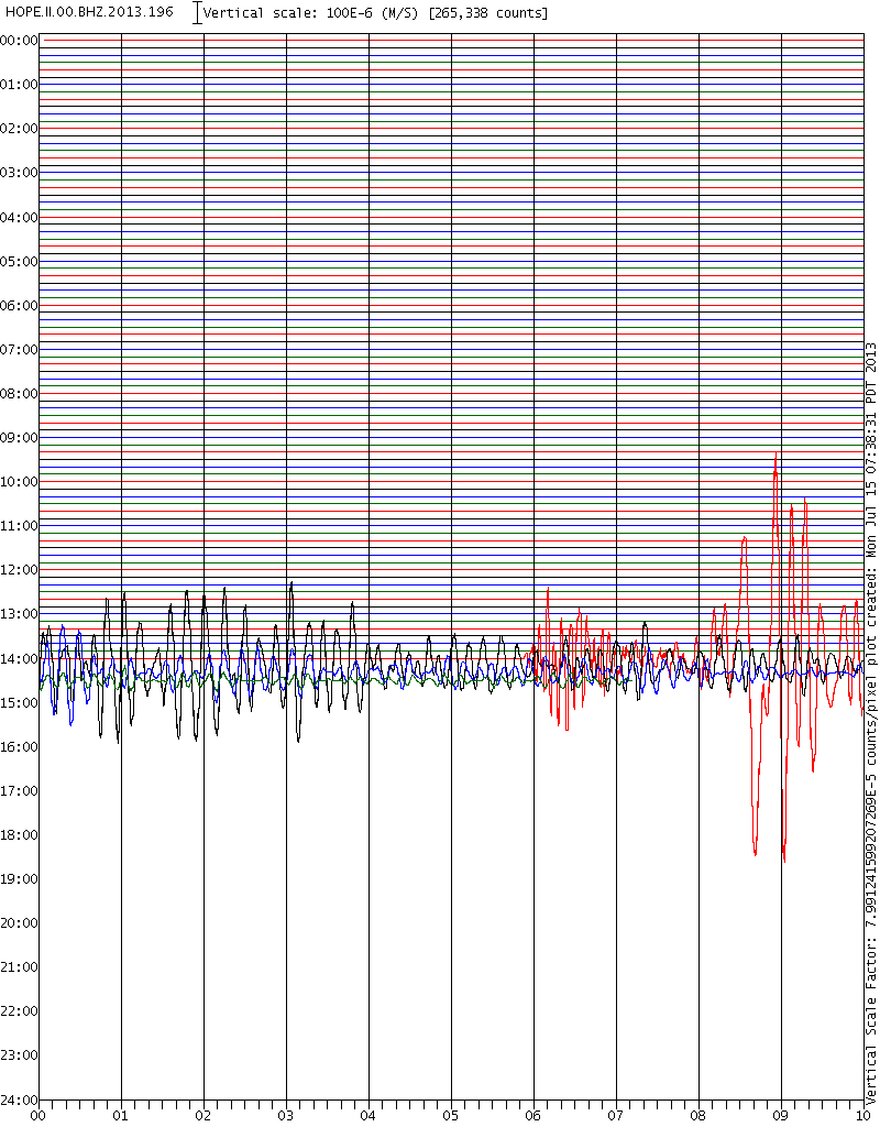
www.emsc-csem.org...
Magnitude Mw 7.2
Region SOUTH SANDWICH ISLANDS REGION
Date time 2013-07-15 14:03:39.0 UTC
Location 60.95 S ; 25.13 W
Depth 10 km
Distances 3647 km SE of Montevideo, Uruguay / pop: 1,270,737 / local time: 11:03:39.0 2013-07-15
3764 km SE of Buenos Aires, Argentina / pop: 13,076,300 / local time: 11:03:39.0 2013-07-15
4456 km SE of Santiago, Chile / pop: 4,837,295 / local time: 10:03:39.0 2013-07-15
edit on 15/7/2013 by PuterMan because: (no reason given)
This one was felt,
I wonder if there are oil fields for what's to come.
www.emsc-csem.org...
Magnitude M 5.1
Region DOMINICAN REPUBLIC
Date time 2013-07-15 14:02:34.0 UTC
Location 19.33 N ; 70.07 W
Depth 40 km
Distances 92 km N of Santo Domingo, Dominican Republic / pop: 2,201,941 / local time: 10:02:34.0 2013-07-15
19 km E of San Francisco de Macorís, Dominican Republic / pop: 124,763 / local time: 10:02:34.0 2013-07-15
I wonder if there are oil fields for what's to come.
update to post by PuterMan
And now the horseplay begins
Useless have now put it at 6.8Mwb
2013-07-15 14:03:43, -60.795, -25.225, 6.8, 33.0, 209Km Sse Of Bristol Island. South Sandwich Isls. [T] +-+15+Jul+13++14%3A03%3A43+UTC)&l l=-60.79570,-25.22570&spn=2,2&f=d&t=h&hl=e][Map]
EMSC have 7.2 and GFZ have 7.0
At present the original 7.2 Mw for the PT network (Pacific Tsunami) is still in the list.
Any bets on whether this drops out of the Mag 7 band anyone?
reply to post by piequal3because14
Not understanding this dark and mysterious statement/question. What is to come and why does it need oil fields?
I wonder if there are oil fields for what's to come.
Not understanding this dark and mysterious statement/question. What is to come and why does it need oil fields?
reply to post by PuterMan
Nah ,will remain 7.2 because they are on vacation on Sandwich Islands.
You mean to 8?
Any bets on whether this drops out of the Mag 7 band anyone?
Nah ,will remain 7.2 because they are on vacation on Sandwich Islands.
reply to post by PuterMan
Because if it is a foreshock and IMHO it is for 8+ we shall see unexpected phenomena like earth exploding in that area.
Not understanding this dark and mysterious statement/question. What is to come and why does it need oil fields?
reply to post by PuterMan
For now, it looks like it is back into the 7+ range, but who knows where it will be in 30 days...
+-+15+Jul+13++14%3A03%3A42+UTC)&l l=-60.86030,-25.18890&spn=2,2&f=d&t=h&hl=e]Location in Google Maps
Derived from Event Data Source: USGS
Powered by QVSData
For now, it looks like it is back into the 7+ range, but who knows where it will be in 30 days...
Magnitude 7.3 - 216Km Sse Of Bristol Island. South Sandwich Islands [T]
+-+15+Jul+13++14%3A03%3A42+UTC)&l l=-60.86030,-25.18890&spn=2,2&f=d&t=h&hl=e]Location in Google Maps
- Date-Time: Monday, July 15, 2013 @ 14:03:42 UTC
- Earthquake location: 60.860°S, 25.189°W,
- Earthquake depth: 31.3 km
- Distances:
216km (134mi) SSE of Bristol Island, South Sandwich Islands
2596km (1613mi) ESE of Ushuaia, Argentina
2841km (1765mi) SE of Punta Arenas, Chile
2851km (1771mi) SE of Rio Gallegos, Argentina
2233km (1387mi) SE of Stanley, Falkland Islands
- Event ID: usb000ief9
Derived from Event Data Source: USGS
Powered by QVSData
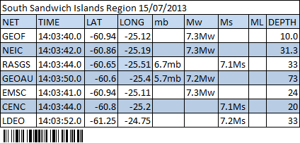
(click table to go to interactive map, opens in new tab/window)
edit on 15-7-2013 by muzzy because: put the wrong barcode in, its the raumati one, but what the heck, how many muzzys are there in raumati
anyway, govt spy bots should be able to figure it out
Hey,guys and gals...
Check out this seismo from vesuvious, just a couple hours ago!
Is this weather related, or is this a little harmonic action??
portale.ov.ingv.it...
This one looks mechanical to me.
portale.ov.ingv.it...
Check out this seismo from vesuvious, just a couple hours ago!
Is this weather related, or is this a little harmonic action??
portale.ov.ingv.it...
This one looks mechanical to me.
portale.ov.ingv.it...
edit on 16-7-2013 by radpetey because: (no reason given)
reply to post by radpetey
On the BKE V (Vesuvio) tab it looks to be quaking?
and big daddy, super volcano Campi Flegrei is getting in on the action, small but stirring nonetheless?
On the BKE V (Vesuvio) tab it looks to be quaking?
and big daddy, super volcano Campi Flegrei is getting in on the action, small but stirring nonetheless?
Time Mag. / Depth Distance Location
Tue, 16 Jul Tue, 16 Jul 06:16 UTC M 0.0 / 0.1 km 7 km Phlegrean Fields
Mon, 15 Jul Mon, 15 Jul 15:46 UTC M 0.0 / 3.1 km 1 km Phlegrean Fields
Mon, 15 Jul 02:13 UTC M 0.0 / 2.9 km 1 km Vesuvius area
Fri, 12 Jul Fri, 12 Jul 20:16 UTC M 0.0 / 4.9 km 3 km Vesuvius area
Fri, 12 Jul 07:35 UTC M 0.5 / 0.2 km 1 km Vesuvius area
new topics
-
Any one suspicious of fever promotions events, major investor Goldman Sachs card only.
The Gray Area: 1 hours ago -
God's Righteousness is Greater than Our Wrath
Religion, Faith, And Theology: 5 hours ago -
Electrical tricks for saving money
Education and Media: 9 hours ago -
VP's Secret Service agent brawls with other agents at Andrews
Mainstream News: 10 hours ago -
Sunak spinning the sickness figures
Other Current Events: 11 hours ago -
Nearly 70% Of Americans Want Talks To End War In Ukraine
Political Issues: 11 hours ago
top topics
-
VP's Secret Service agent brawls with other agents at Andrews
Mainstream News: 10 hours ago, 9 flags -
Cats Used as Live Bait to Train Ferocious Pitbulls in Illegal NYC Dogfighting
Social Issues and Civil Unrest: 14 hours ago, 8 flags -
Electrical tricks for saving money
Education and Media: 9 hours ago, 4 flags -
Nearly 70% Of Americans Want Talks To End War In Ukraine
Political Issues: 11 hours ago, 3 flags -
Sunak spinning the sickness figures
Other Current Events: 11 hours ago, 3 flags -
Late Night with the Devil - a really good unusual modern horror film.
Movies: 13 hours ago, 2 flags -
Any one suspicious of fever promotions events, major investor Goldman Sachs card only.
The Gray Area: 1 hours ago, 2 flags -
The Good News According to Jesus - Episode 1
Religion, Faith, And Theology: 16 hours ago, 1 flags -
God's Righteousness is Greater than Our Wrath
Religion, Faith, And Theology: 5 hours ago, 0 flags
active topics
-
God's Righteousness is Greater than Our Wrath
Religion, Faith, And Theology • 11 • : andy06shake -
SETI chief says US has no evidence for alien technology. 'And we never have'
Aliens and UFOs • 60 • : Scratchpost -
Election Year 2024 - Interesting Election-Related Tidbits as They Happen.
2024 Elections • 73 • : Threadbarer -
Sunak spinning the sickness figures
Other Current Events • 8 • : McUrnsalso -
-@TH3WH17ERABB17- -Q- ---TIME TO SHOW THE WORLD--- -Part- --44--
Dissecting Disinformation • 661 • : Justoneman -
HORRIBLE !! Russian Soldier Drinking Own Urine To Survive In Battle
World War Three • 36 • : TheMisguidedAngel -
British TV Presenter Refuses To Use Guest's Preferred Pronouns
Education and Media • 146 • : Consvoli -
Nearly 70% Of Americans Want Talks To End War In Ukraine
Political Issues • 19 • : Consvoli -
Terrifying Encounters With The Black Eyed Kids
Paranormal Studies • 76 • : Consvoli -
Samuel Aun Woer
Religion, Faith, And Theology • 27 • : helebi20