It looks like you're using an Ad Blocker.
Please white-list or disable AboveTopSecret.com in your ad-blocking tool.
Thank you.
Some features of ATS will be disabled while you continue to use an ad-blocker.

Quake Watch 2013
page: 10share:
2013-01-13 16:28:27.6 13min ago 25.83 N 110.29 W 10 5.2 GULF OF CALIFORNIA
Magnitude M 5.2
Region GULF OF CALIFORNIA
Date time 2013-01-13 16:28:27.6 UTC
Location 25.83 N ; 110.29 W
Depth 10 km
Distances 754 km SW Juárez (pop 1,402,990 ; local time 09:28:27.6 2013-01-13)
129 km W Los mochis (pop 214,601 ; local time 09:28:27.6 2013-01-13)
108 km E Loreto (pop 11,227 ; local time 09:28:27.6 2013-01-13)
www.emsc-csem.org...
reply to post by MariaLida
GFZ say M 5.3 depth 10 km ..
geofon.gfz-potsdam.de...
USGS M 5.5 ..
Magnitude 5.5
Date-Time
Sunday, January 13, 2013 at 16:28:29 UTC
Sunday, January 13, 2013 at 09:28:29 AM at epicenter
Location 26.052°N, 110.059°W
Depth 10 km (6.2 miles)
Region GULF OF CALIFORNIA
Distances
90 km (56 miles) W (280°) from Ahome, Sinaloa, Mexico
97 km (60 miles) SSW (206°) from Huatabampo, Sonora, Mexico
113 km (70 miles) WNW (286°) from Los Mochis, Sinaloa, Mexico
987 km (613 miles) SE (135°) from Tijuana, Baja California, Mexico
earthquake.usgs.gov...
edit on 13-1-2013 by MariaLida because: (no reason given)
M5.5 - 78km W of Higuera de Zaragoza, Mexico
Event Time
2013-01-13 16:28:29 UTC
2013-01-13 09:28:29 UTC-07:00 at epicenter
2013-01-13 11:28:29 UTC-05:00 system time
Location
26.052°N 110.059°W depth=10.0km (6.2mi)
Nearby Cities
78km (48mi) W of Higuera de Zaragoza, Mexico
88km (55mi) W of Ahome, Mexico
96km (60mi) SSW of Huatabampo, Mexico
113km (70mi) WNW of Los Mochis, Mexico
842km (523mi) SSE of Phoenix, Arizona
First aftershock ..
Magnitude 4.4
Date-Time
Sunday, January 13, 2013 at 17:04:47 UTC
Sunday, January 13, 2013 at 10:04:47 AM at epicenter
Time of Earthquake in other Time Zones
Location 26.061°N, 110.283°W
Depth 10.1 km (6.3 miles)
Region GULF OF CALIFORNIA
Distances 99 km (61 miles) SW of Etchoropo, Mexico
107 km (66 miles) SW of Huatabampo, Mexico
107 km (66 miles) E of Loreto, Mexico
110 km (68 miles) W of Ahome, Mexico
earthquake.usgs.gov...
GFZ now say M 5.7 ..
F-E Region: Gulf of California
Mw Beach Ball
Time: 2013-01-13 16:28:30.9 UTC
Magnitude: 5.7(Mw)
Epicenter: 110.06°W 25.98°N
Depth: 10 km
Status: C - confirmed
geofon.gfz-potsdam.de...
EMSC M 5.5 ..
edit on 13-1-2013 by MariaLida because: (no reason given)
reply to post by Nyiah
sometimes its wind, could also be volcanic earthquakes, it is a volcanic island after all.
sometimes its wind, could also be volcanic earthquakes, it is a volcanic island after all.
last evening NZDT
5.4, 2013-01-13 12:17:42.208JST, 39.1315, 142.3480, 43.8km, Iwate-ken Oki (nr East Coast of Honshu) NIED preliminary
JMA official page has it at 4.8ML
www.jma.go.jp... ,
USGS 5.0mb, 4.4ML
GFZ 5.1 Unk
5.4, 2013-01-13 12:17:42.208JST, 39.1315, 142.3480, 43.8km, Iwate-ken Oki (nr East Coast of Honshu) NIED preliminary
JMA official page has it at 4.8ML
www.jma.go.jp... ,
USGS 5.0mb, 4.4ML
GFZ 5.1 Unk
edit on 13-1-2013 by muzzy because: (no reason given)
2013-01-13 21:23:27.0 2hr 14min ago 20.13 S 69.17 W 80 5.5 TARAPACA, CHILE
Magnitude 5.5
Date-Time
Sunday, January 13, 2013 at 21:23:27 UTC
Sunday, January 13, 2013 at 06:23:27 PM at epicenter
Time of Earthquake in other Time Zones
Location 20.102°S, 69.195°W
Depth 83.7 km (52.0 miles)
Region TARAPACA, CHILE
Distances 99 km (61 miles) E of Iquique, Chile
214 km (132 miles) SSE of Arica, Chile
237 km (147 miles) W of Colchani, Bolivia
243 km (150 miles) NNE of Tocopilla, Chile
earthquake.usgs.gov...
edit on 13-1-2013 by MariaLida because: (no reason given)
Japan reviewed data to end of 11th Jan
1209 mag1
659 mag2
200 mag3
50 mag4
9 mag5
0 mag6
0 mag7
2127 Total
17,782.5 TTNT energy released
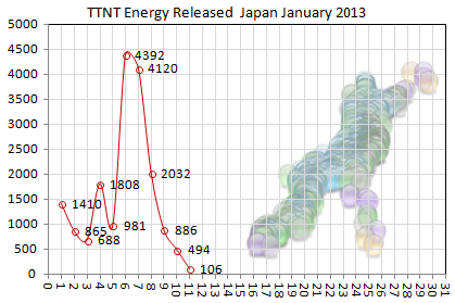
interactive map of those
1209 mag1
659 mag2
200 mag3
50 mag4
9 mag5
0 mag6
0 mag7
2127 Total
17,782.5 TTNT energy released
interactive map of those
New Zealand preliminary data to 12th Jan 2013
124 mag1
356 mag2
77 mag3
9 mag4
1 mag5
0 mag6
0 mag7
570 total
3553 TTNT energy released
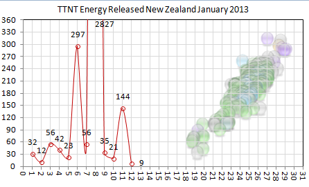
interactive map of those
just no comparison is there
124 mag1
356 mag2
77 mag3
9 mag4
1 mag5
0 mag6
0 mag7
570 total
3553 TTNT energy released
interactive map of those
just no comparison is there
edit on 13-1-2013 by muzzy because: (no reason given)
Some of today's 'quakes::
4.7 18km NW of Redoubt Volcano, Alaska 2013-01-13 07:44:08 60.534°N 152.879°W 131.3
4.3 84km WSW of Cantwell, Alaska 2013-01-13 17:59:59 63.148°N 150.627°W 124.7
4.9 Carlsberg Ridge 2013-01-13 19:58:06 1.953°S 68.260°E 10.0
4.5 133km SE of Ahwar, Yemen 2013-01-13 20:14:57 12.541°N 47.440°E 6.4
4.6 260km SW of Gizo, Solomon Islands 2013-01-13 20:57:15 9.752°S 155.148°E 10.0
4.1 68km SE of Bitung, Indonesia 2013-01-13 21:06:14 1.068°N 125.675°E 100.0
earthquake.usgs.gov...
Nice bout of movement in the 4 range overall today, it looks like.
one more for today
Italian data to 14th January 2013
421 mag1
71 mag2
5 mag3
1 mag4
0 mag5
0 mag6
0 mag7
498 total
55.5 TTNT energy released
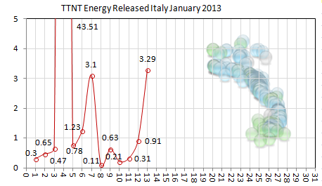
interactive map of that
I hadn't looked at Italy yet this year, did anyone notice the 4.3 on the 4th Jan, NW of Mt. Etna at Cesaro, had quite a few aftershocks (23) in the day/days following
same map but zoomed in on Cesaro
Pollino Nat Park ( Calabria) is still pumping out the mag 1's since the 5.0 there in October 2012
and a reasonable sized 28 event swarm of micros near Arquata del Tronto, Province of Ascoli Piceno (down the spine)
Re the background on each graph, I accidentally clicked the wrong button on GPSVisualiser one day ages ago and just got the icons, no map, had thought since then that its pretty cool how you can almost tell what country it is from the earthquake icons layout, sort of like a seismic signature
knew I'd find a use for it one rainy day
Italian data to 14th January 2013
421 mag1
71 mag2
5 mag3
1 mag4
0 mag5
0 mag6
0 mag7
498 total
55.5 TTNT energy released
interactive map of that
I hadn't looked at Italy yet this year, did anyone notice the 4.3 on the 4th Jan, NW of Mt. Etna at Cesaro, had quite a few aftershocks (23) in the day/days following
same map but zoomed in on Cesaro
Pollino Nat Park ( Calabria) is still pumping out the mag 1's since the 5.0 there in October 2012
and a reasonable sized 28 event swarm of micros near Arquata del Tronto, Province of Ascoli Piceno (down the spine)
Re the background on each graph, I accidentally clicked the wrong button on GPSVisualiser one day ages ago and just got the icons, no map, had thought since then that its pretty cool how you can almost tell what country it is from the earthquake icons layout, sort of like a seismic signature
knew I'd find a use for it one rainy day
Please be aware if you are using any version of the QVSData program that Australia changed some data formats @0240 UTC today which has broken the
Australia import.
I am working on fixing it and hope to have an updated program by this evening.
I am working on fixing it and hope to have an updated program by this evening.
image doesn't want to work. Forget it.
edit on 14-1-2013 by Mister1k because: (no reason given)
edit on 14-1-2013 by Mister1k because: (no reason
given)
edit on 14-1-2013 by Mister1k because: (no reason given)
edit on 14-1-2013 by Mister1k because: (no reason
given)
edit on 14-1-2013 by Mister1k because: (no reason given)
2013-01-14 14:55:54.5 14min ago 55.18 N 134.52 W 10 5.5 SOUTHEASTERN ALASKA
Magnitude 5.5 (Preliminary magnitude — update expected within 15 minutes)
Date-Time
Monday, January 14, 2013 at 14:55:52 UTC
Monday, January 14, 2013 at 05:55:52 AM at epicenter
Location 55.100°N, 134.675°W
Depth 10 km (6.2 miles) set by location program
Region SOUTHEASTERN ALASKA
Distances
106 km (66 miles) WSW (247°) from Craig, AK
113 km (70 miles) WSW (244°) from Klawock, AK
116 km (72 miles) SSW (213°) from Edna Bay, AK
1017 km (632 miles) NW (314°) from Vancouver, British Columbia, Canada
earthquake.usgs.gov...
earthquake.usgs.gov...
Version 1.5.59.1 of QVS data now available.
See the link in my signature.
See the link in my signature.
Is the Partay at Carlesberg over - maybe not quite
Just stay out of the way if Heineken and Smirnoff appear!
Prov,Date/Time UTC,Latitude,Longitude,Magnitude,Depth(Km),Location
emsc,2013-01-14 23:40:47, -2.044, 68.020, 4.8, 33.0, Carlsberg Ridge
emsc,2013-01-14 00:58:11, -1.899, 68.102, 4.8, 33.0, Carlsberg Ridge
emsc,2013-01-12 07:06:11, -1.927, 68.035, 4.6, 10.0, Carlsberg Ridge
emsc,2013-01-11 12:38:22, -1.939, 68.221, 4.7, 10.0, Carlsberg Ridge
emsc,2013-01-09 21:20:07, -1.810, 67.972, 4.7, 10.0, Carlsberg Ridge
emsc,2013-01-09 14:42:40, -1.754, 67.883, 4.5, 10.0, Carlsberg Ridge
emsc,2013-01-09 13:32:02, -1.727, 67.932, 4.5, 10.0, Carlsberg Ridge
emsc,2013-01-09 10:51:30, -1.991, 68.001, 4.9, 10.0, Carlsberg Ridge
emsc,2013-01-09 10:35:52, -1.924, 67.931, 4.6, 10.0, Carlsberg Ridge
emsc,2013-01-09 10:27:47, -1.916, 67.878, 4.9, 10.0, Carlsberg Ridge
emsc,2013-01-09 10:08:45, -1.972, 67.709, 4.8, 10.0, Carlsberg Ridge
emsc,2013-01-09 09:40:53, -1.885, 67.930, 4.8, 10.0, Carlsberg Ridge
emsc,2013-01-09 09:02:40, -1.954, 67.889, 4.8, 10.0, Carlsberg Ridge
emsc,2013-01-09 06:50:38, -1.876, 68.018, 4.8, 10.0, Carlsberg Ridge
emsc,2013-01-09 06:21:56, -1.878, 68.037, 4.8, 5.0, Carlsberg Ridge
emsc,2013-01-09 05:27:05, -1.812, 67.923, 5.0, 10.0, Carlsberg Ridge
emsc,2013-01-09 04:46:29, -1.858, 67.924, 4.9, 10.0, Carlsberg Ridge
emsc,2013-01-08 23:42:57, -2.237, 67.967, 4.7, 10.0, Carlsberg Ridge
emsc,2013-01-08 23:38:44, -1.957, 68.032, 4.7, 10.0, Carlsberg Ridge
emsc,2013-01-08 23:31:49, -1.950, 68.077, 4.6, 10.0, Carlsberg Ridge
emsc,2013-01-08 22:35:47, -1.904, 67.978, 4.4, 10.0, Carlsberg Ridge
Just stay out of the way if Heineken and Smirnoff appear!
Here we have an interesting if small earthquake.
Although the magnitude in Mw would be ~mag 5 never mind the magnitude, feel the depth. A subduction quake on the left hand side of Japan - opposite the Eastern end of the Nankai Trough but probably from the Japan Trench as the Pacific plate subducts, as it is too deep for the Philippine plate I think.
2013-01-14 16:20:04, 36.121, 136.996, 4.5, 266.9, Nr. W. Coast Of Honshu. Japan [Map]
Although the magnitude in Mw would be ~mag 5 never mind the magnitude, feel the depth. A subduction quake on the left hand side of Japan - opposite the Eastern end of the Nankai Trough but probably from the Japan Trench as the Pacific plate subducts, as it is too deep for the Philippine plate I think.
edit on 14/1/2013 by PuterMan because: (no reason given)
reply to post by PuterMan
another one !
I seen a couple of 4's (purple ones) on the NIED preliminary map on the 13th over west of Honshu and Hokkaido in the Sea of Japan. They were deep too.
I've see a change in the activity for Japan happening this last week, that clump of quakes that were the aftershocks of the 7.3 at the Japan Trench (Far of East Coast of Honshu) have tapered away and there is more movement to the north (and west) now.
Not sure what it means?, something coming up for China/Russia?
I'll go have a look at NIED now for the last 24hrs, its about that time of day.
yep there it is on NIED,
and another deep one in the Sea of Japan 1 and a bit hours earlier
also a 4.1 just north of Tokyo, moderately deep too.
map of those
something is definitely up!
another one !
I seen a couple of 4's (purple ones) on the NIED preliminary map on the 13th over west of Honshu and Hokkaido in the Sea of Japan. They were deep too.
Lat/Long: 37.285 134.9832
UTC: 13/01/2013 04:52:32
JST: 13/01/2013 13:52:32
Depth: 387.7
Mag: 4.2 ML
Lat/Long: 44.6683 140.9905
UTC: 13/01/2013 14:07:23
JST: 13/01/2013 23:07:23
Depth: 277.2
Mag: 4.1 ML
I've see a change in the activity for Japan happening this last week, that clump of quakes that were the aftershocks of the 7.3 at the Japan Trench (Far of East Coast of Honshu) have tapered away and there is more movement to the north (and west) now.
Not sure what it means?, something coming up for China/Russia?
I'll go have a look at NIED now for the last 24hrs, its about that time of day.
edit on 14-1-2013 by muzzy because: (no reason
given)
yep there it is on NIED,
Lat/Long: 36.1996 137.161
UTC: 14/01/2013 16:20:05
JST: 15/01/2013 01:20:05
Depth: 274.8
Mag: 4.4 ML
and another deep one in the Sea of Japan 1 and a bit hours earlier
Lat/Long: 37.3297 135.0666
UTC: 14/01/2013 14:45:37
JST: 14/01/2013 23:45:37
Depth: 376.8
Mag: 4.2 ML
also a 4.1 just north of Tokyo, moderately deep too.
Lat/Long: 35.9252 139.5482
UTC: 14/01/2013 09:36:28
JST: 14/01/2013 18:36:28
Depth: 92.1
Mag: 4.1 ML
map of those
something is definitely up!
edit on 14-1-2013 by muzzy because: (no reason given)
reply to post by muzzy
Thanks for doing that map Muzzy, and for the additional information. It is the deeper ones which interest me and I have picked out the three purple coloured icon from the map.
Looking at this map of the Wadati-Benioff zone (one set) of the subducting Pacific plate these three quakes appear to match the zone. First here is the map:
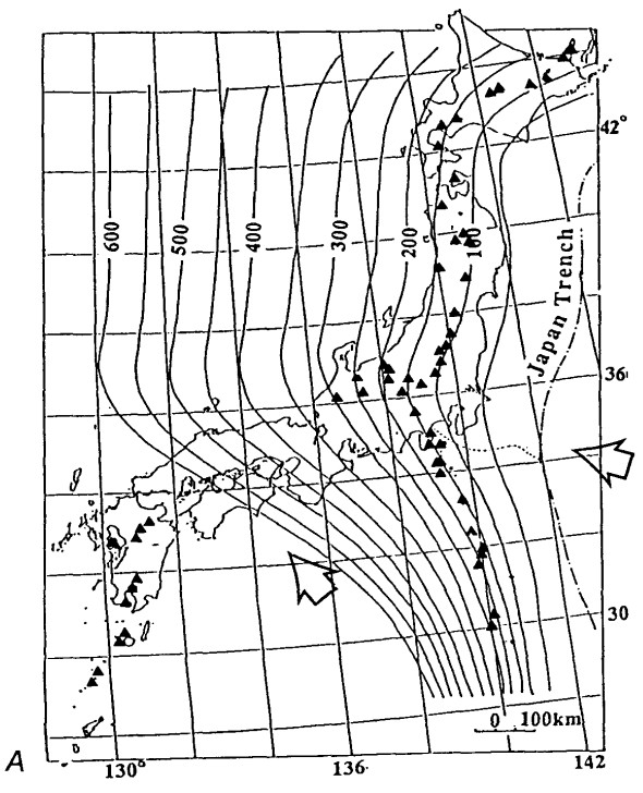
I have attempted to overlay this on to your map with just the three icons - the deeper quakes.
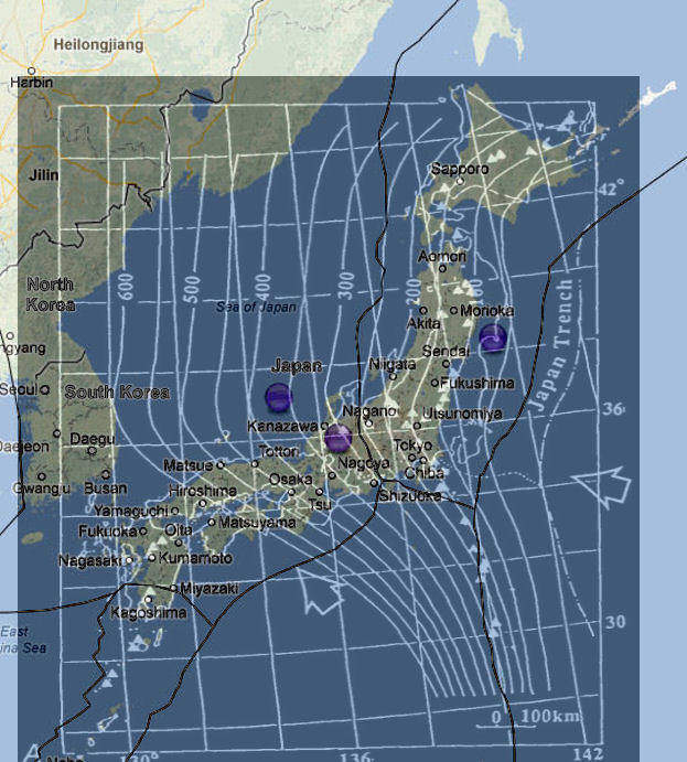
It is not perfect but I believe that if this was done accurately those three icons would fall neatly into the zone bands of depth as portrayed. This would mean that a subduction movement is happening I venture to suggest even though the evidence is somewhat flimsy as all the maps and locations are inevitably not perfectly accurate.
Sorry, forgot to add: The document from which that Wadati-Benioff map was taken is this which is a PDF file the source of which I do not know at this time. The diagram is on page 5 (194) in the document.
You can find confirmation of these depth contours here: Japan in a subduction zone. See the diagram No 4.
The direct link to that diagram shows both the A and B diagrams in the PDF overlaid. You can see the complexity that is Japan!!
PDF of that web page section pages 1/2/3 - the whole site is worth a read however
Thanks for doing that map Muzzy, and for the additional information. It is the deeper ones which interest me and I have picked out the three purple coloured icon from the map.
Looking at this map of the Wadati-Benioff zone (one set) of the subducting Pacific plate these three quakes appear to match the zone. First here is the map:
I have attempted to overlay this on to your map with just the three icons - the deeper quakes.
It is not perfect but I believe that if this was done accurately those three icons would fall neatly into the zone bands of depth as portrayed. This would mean that a subduction movement is happening I venture to suggest even though the evidence is somewhat flimsy as all the maps and locations are inevitably not perfectly accurate.
Sorry, forgot to add: The document from which that Wadati-Benioff map was taken is this which is a PDF file the source of which I do not know at this time. The diagram is on page 5 (194) in the document.
You can find confirmation of these depth contours here: Japan in a subduction zone. See the diagram No 4.
The direct link to that diagram shows both the A and B diagrams in the PDF overlaid. You can see the complexity that is Japan!!
PDF of that web page section pages 1/2/3 - the whole site is worth a read however
edit on 15/1/2013 by PuterMan because: To add information link
new topics
-
VP's Secret Service agent brawls with other agents at Andrews
Mainstream News: 1 hours ago -
Sunak spinning the sickness figures
Other Current Events: 1 hours ago -
Nearly 70% Of Americans Want Talks To End War In Ukraine
Political Issues: 1 hours ago -
Late Night with the Devil - a really good unusual modern horror film.
Movies: 3 hours ago -
Cats Used as Live Bait to Train Ferocious Pitbulls in Illegal NYC Dogfighting
Social Issues and Civil Unrest: 5 hours ago -
The Good News According to Jesus - Episode 1
Religion, Faith, And Theology: 7 hours ago -
HORRIBLE !! Russian Soldier Drinking Own Urine To Survive In Battle
World War Three: 9 hours ago -
Bobiverse
Fantasy & Science Fiction: 11 hours ago
top topics
-
Florida man's trip overseas ends in shock over $143,000 T-Mobile phone bill
Social Issues and Civil Unrest: 12 hours ago, 8 flags -
SETI chief says US has no evidence for alien technology. 'And we never have'
Aliens and UFOs: 15 hours ago, 7 flags -
Cats Used as Live Bait to Train Ferocious Pitbulls in Illegal NYC Dogfighting
Social Issues and Civil Unrest: 5 hours ago, 7 flags -
VP's Secret Service agent brawls with other agents at Andrews
Mainstream News: 1 hours ago, 5 flags -
Former Labour minister Frank Field dies aged 81
People: 14 hours ago, 4 flags -
HORRIBLE !! Russian Soldier Drinking Own Urine To Survive In Battle
World War Three: 9 hours ago, 3 flags -
Bobiverse
Fantasy & Science Fiction: 11 hours ago, 3 flags -
Nearly 70% Of Americans Want Talks To End War In Ukraine
Political Issues: 1 hours ago, 3 flags -
Sunak spinning the sickness figures
Other Current Events: 1 hours ago, 3 flags -
Late Night with the Devil - a really good unusual modern horror film.
Movies: 3 hours ago, 2 flags
active topics
-
Nearly 70% Of Americans Want Talks To End War In Ukraine
Political Issues • 9 • : DBCowboy -
SETI chief says US has no evidence for alien technology. 'And we never have'
Aliens and UFOs • 40 • : Irishhaf -
President BIDEN Vows to Make Americans Pay More Federal Taxes in 2025 - Political Suicide.
2024 Elections • 124 • : Justoneman -
Ditching physical money
History • 20 • : GENERAL EYES -
Sunak spinning the sickness figures
Other Current Events • 3 • : NoCorruptionAllowed -
VP's Secret Service agent brawls with other agents at Andrews
Mainstream News • 13 • : DAVID64 -
The Reality of the Laser
Military Projects • 42 • : Zaphod58 -
HORRIBLE !! Russian Soldier Drinking Own Urine To Survive In Battle
World War Three • 27 • : RickyD -
Mood Music Part VI
Music • 3100 • : TheDiscoKing -
Breaking Baltimore, ship brings down bridge, mass casualties
Other Current Events • 484 • : ThatSmellsStrange