It looks like you're using an Ad Blocker.
Please white-list or disable AboveTopSecret.com in your ad-blocking tool.
Thank you.
Some features of ATS will be disabled while you continue to use an ad-blocker.

Volcano Watch , 2013
page: 4share:
Not sure if anyone has seen this yet so thought i would post for all to peruse.
It seems that gravity can influence volcanic activity. Whilst this has been suspected for a while, scientists have now studied / are studying the link.
Gravity makes volcanoes sag, influencing eruptions.
It seems that gravity can influence volcanic activity. Whilst this has been suspected for a while, scientists have now studied / are studying the link.
Gravity makes volcanoes sag, influencing eruptions.
23 February 2013, 3:30pm - White Island exhibiting minor ash venting; Volcanic Alert raised to Level 2, Aviation Colour Code changed to Orange.
Minor ash venting occurred at White Island at approximately 11:30 am and 1:30 pm today. GNS Science volcanologists are monitoring the activity and further information will be released as soon as it is available.
Arthur Jolly
Duty Volcanologist
GNS
info.geonet.org.nz...
Seismo has gone nuts in the last 4 hours
geonet.org.nz...
According to news articles, INGEMMET recorded 536 earthquakes from Sabancaya, or about 20 per hour, during 22-23 February. About 80 homes were damaged by the earthquakes, causing some evacuations. A plume rose 100 m; plumes had been intermittently visible since 15 January.
www.volcano.si.edu...
There does not seem to be much detail yet. I have not had a chance to look at the earthquakes yet as I am away from home at present.
reply to post by ericblair4891
Very nice Eric. Yet another piece of illogical warmist BS being fed to the media to keep the hype going.
Tell me, in what way has the volcanic output significantly increased in the last 10 years to have this effect? Answer it has not, but the AGW crowd are struggling to keep the global climate warming change disaster BS going as the Sun goes into a quiet phase and we face a Maunder type minimum. This is not caused by AGW, which if it does warm the planet should be encouraged because we need it, or will in the next 30 years, but by the normal cycles of our star. The Sun was at a major high until around 2000 and now the output is falling. Greenhouse gases - no. Volcanoes - no. Sun - yes.
It is about time the warmist BSers admitted their errors and accepted that the main driver of our climate is the Sun. Now there is a surprise!
reply to post by PuterMan
In my humble opinion, the answer is two-fold. No, make that three fold. No, make that four-fold. When I read the report I was agruing China has had a major influence in keeping the world cooler than it would be without the dirty air. Now, these new guys here, they say no, and downplay man made pollutants. Each suspected cause is not the only thing. And you rightly add in the sun. But there's way more to the story. Alaskan soot. Indian women burnig cow dung. Humans burning down whole mountain sides to plant beans. I just got angry. Because I could go on and on. Larger forest fires due to stupid practices. More and more. The freakin' sky, i censored fu , the sky is a sewer. End of story. This less clean burning has slowed the rate of climatic increase. But the world is still heating. Just more slowly. And this will change once they clean up there act. And when India has more nuke plants they'll be less soot. Just wait.
I can't debate. Brain is on fire. Just stating facts. We are not decreasing the things we burn. We are increasing it day after day. By millions of gallons. Fact
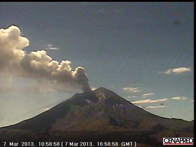
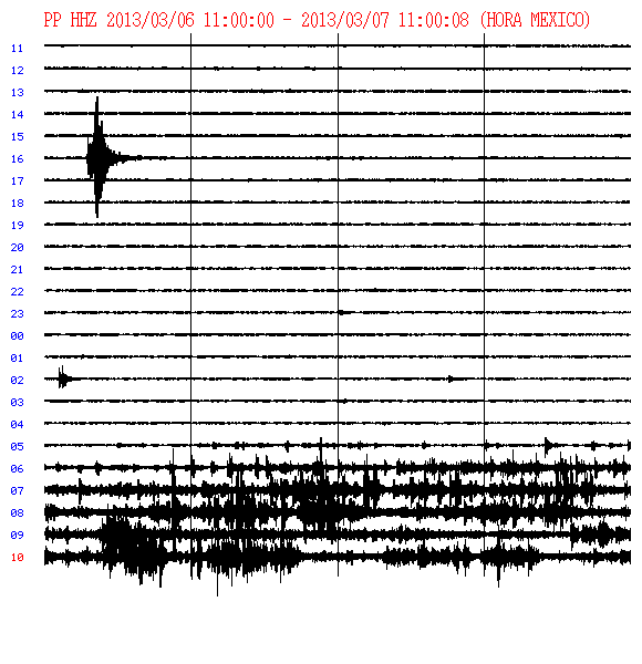
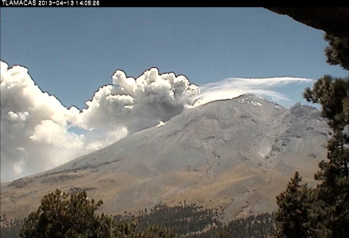
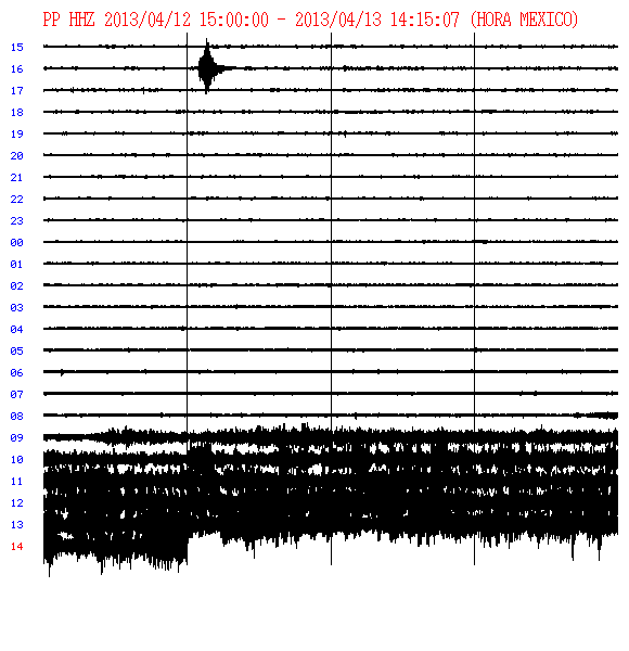
Popo is exhausting. And there's some moderate volcanic tremor.
www.telegraph.co.uk...
Etna was busy the other day.
edit on 7-3-2013 by ericblair4891 because: (no reason given)
Hey gang. I thought I'd drop this off and you could give us your thoughts?
Off hand I'd say this is a bad sign, but what do I know?
Our bud Q found this and dropped it on the Japan thread so I thought I'd get your input.
The water level of Kawaguchi lake is rapidly decreasing beside Mt. Fuji, “There is no natural outlet”
fukushima-diary.com...
Eric, I love reading your posts but that profile pic of yours always makes me cringe. lol
It's a toe- no biggie.
No, wrong- it is a biggie toe. My little one's toe.
No apologies form me.
I could post my ugly puss, but that'd cause more than cringing.
Maybe I should post a picture of just my forehead.
And the big bump I got from beating my head against the pavement.
Nothing is harder than my head.
No joke.
Now to the volcanoes. Why you gatta upset me? This is a joke.
It's mine own fault for double-checking.
I can't say the graphs of the drop are accurate. Reason being, when watching Yellowstone's meters, most the time it's weather and such that mess with data. I haven't found a secondary scource yet for the water drop. I did however check up on Fuji itself. If 1+1 is to be put together, I don't like what the oversimplified answer may be. So, I'll assume I'm not familiar enough with Fuji to say anything. But I don't like volcanic lakes. Actually, I love them. But I'm a sick ...
I'm posting a report that describes Fuji and the scientists guessimations. Aren't we all watching an guesses. We could be betting on horses. No. That's not it for me. Yes, the thought of chance and calculating odds are exciting to me. But that's not how I ended up here. I think I'm like my Dad's little Terrier. Just some little stump of a dog who thinks they can punch above their wieght. The Lil' Yorkie thinks its a watchdog. Like when a bunch of Terriers stand up to a bear or larger animal. You have to wonder what gives them that courage. Breeding. Sorry.
www.scmp.com...
Why wouldn't Fuji erupt?
Of course it will. It's active. And. Two years ago, there were only two things on my mind. No, three. Arkansas, Japan, and other.
When you get a giantic slab moving that distance, over that much ground, loud enough to make a bang out into space... Wow, I think some magmas' gotta move somewheres. And, this mixing and dancing are going to change the dynamic and...
www.scmp.com...
Popo is active. Something's up, or rather done the slope and there is smoke. For all I know it's a brush fire. Although, I saw a shot that made it look like there's been a slide and it seems there may have also been a lava flow? I missed the close up shot. Bad me.
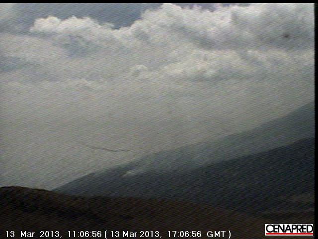
I caught a close up of the lower slope. It's not a very clear shot, but I think you can make out the smoke.
I hate coincidences. For example, I found out that Fuji is a kind of bottled water. But I didn't find out that infomation when I made a search of Mount Fuji earlier today. The stange this is I found out this information after I got off the computer and went back to watching the Sopranos. I had forgotten about Fuji. This is no wonder because I am not (yet) obsessed with Fuji. The only reason I read up on it was because of the lake. The dropping lake? While I was watching a scene I happened to read the bottle a character was holding. At first it didn't register consciously. I had to go back and check because some other part of my brain wanted clarification. Sure enough, it said Fuji. No. Was I reading it right? Yup, I had to stop watching and check online that such a thing existed. Yup, it's water. I didn't know this existed. I've never bought it, nor ever seen it on the selves of any store. This was news to me.
I suppose the don't pump out too much. Anyway. I don't really believe in ... i don't know
and now for something completely different...
ufos are over Popo again. hehe.
Every once in a while. I think I see one. But then I realize it's a bird, or smudge, or Jupiter. I'm not saying the following video shows Jupiter, or it's reflection of something else. Once I thought there was a UFO there. But when it got darker, I realized someone had left the lightbulb on inside the building which houses the camera.
news.gather.com...
also tremor is picking up at POPO. it's a bit hard to makre out the difference between cloud, steam, dust, and or smoke.
Also, this is problably my imagination, but the americas south of the U.S. (for now) seems rather active. but honestly I have been watching closely enough to tell exactly
problably nothing:
I feel like I'm being misdirected. I'm not even sure where I was supposed to be looking in the first place. The other day I'm thinking about Japan. Then back to Yellowstone, (maybe ice breaking up after last week's small swarm), down to Popo, maybe Cali, then wondering what's up in the east of the U.S. earthquake wise. Then back to Fuji. Althewhile, aliens, who must be those in Scientology, are flushing beings into the cerimonial cremitorium. Sorry.
I'm get a vibe, something's up. And although I don't hear footsteps persay, I wouldn't be at all surprised.
I think all the pushing by Austrailia up on southeast Asia is now going to shift and the west is next.
Clearly, I am as obsured as the cam at Popo today.
fuzzy
spotty
and there's too much stuff to be sure you can identify everything
i'm blaming the ufos
No, wrong- it is a biggie toe. My little one's toe.
No apologies form me.
I could post my ugly puss, but that'd cause more than cringing.
Maybe I should post a picture of just my forehead.
And the big bump I got from beating my head against the pavement.
Nothing is harder than my head.
No joke.
Now to the volcanoes. Why you gatta upset me? This is a joke.
It's mine own fault for double-checking.
I can't say the graphs of the drop are accurate. Reason being, when watching Yellowstone's meters, most the time it's weather and such that mess with data. I haven't found a secondary scource yet for the water drop. I did however check up on Fuji itself. If 1+1 is to be put together, I don't like what the oversimplified answer may be. So, I'll assume I'm not familiar enough with Fuji to say anything. But I don't like volcanic lakes. Actually, I love them. But I'm a sick ...
I'm posting a report that describes Fuji and the scientists guessimations. Aren't we all watching an guesses. We could be betting on horses. No. That's not it for me. Yes, the thought of chance and calculating odds are exciting to me. But that's not how I ended up here. I think I'm like my Dad's little Terrier. Just some little stump of a dog who thinks they can punch above their wieght. The Lil' Yorkie thinks its a watchdog. Like when a bunch of Terriers stand up to a bear or larger animal. You have to wonder what gives them that courage. Breeding. Sorry.
www.scmp.com...
Why wouldn't Fuji erupt?
Of course it will. It's active. And. Two years ago, there were only two things on my mind. No, three. Arkansas, Japan, and other.
When you get a giantic slab moving that distance, over that much ground, loud enough to make a bang out into space... Wow, I think some magmas' gotta move somewheres. And, this mixing and dancing are going to change the dynamic and...
www.scmp.com...
Popo is active. Something's up, or rather done the slope and there is smoke. For all I know it's a brush fire. Although, I saw a shot that made it look like there's been a slide and it seems there may have also been a lava flow? I missed the close up shot. Bad me.
I caught a close up of the lower slope. It's not a very clear shot, but I think you can make out the smoke.
I hate coincidences. For example, I found out that Fuji is a kind of bottled water. But I didn't find out that infomation when I made a search of Mount Fuji earlier today. The stange this is I found out this information after I got off the computer and went back to watching the Sopranos. I had forgotten about Fuji. This is no wonder because I am not (yet) obsessed with Fuji. The only reason I read up on it was because of the lake. The dropping lake? While I was watching a scene I happened to read the bottle a character was holding. At first it didn't register consciously. I had to go back and check because some other part of my brain wanted clarification. Sure enough, it said Fuji. No. Was I reading it right? Yup, I had to stop watching and check online that such a thing existed. Yup, it's water. I didn't know this existed. I've never bought it, nor ever seen it on the selves of any store. This was news to me.
I suppose the don't pump out too much. Anyway. I don't really believe in ... i don't know
and now for something completely different...
ufos are over Popo again. hehe.
Every once in a while. I think I see one. But then I realize it's a bird, or smudge, or Jupiter. I'm not saying the following video shows Jupiter, or it's reflection of something else. Once I thought there was a UFO there. But when it got darker, I realized someone had left the lightbulb on inside the building which houses the camera.
news.gather.com...
also tremor is picking up at POPO. it's a bit hard to makre out the difference between cloud, steam, dust, and or smoke.
Also, this is problably my imagination, but the americas south of the U.S. (for now) seems rather active. but honestly I have been watching closely enough to tell exactly
problably nothing:
I feel like I'm being misdirected. I'm not even sure where I was supposed to be looking in the first place. The other day I'm thinking about Japan. Then back to Yellowstone, (maybe ice breaking up after last week's small swarm), down to Popo, maybe Cali, then wondering what's up in the east of the U.S. earthquake wise. Then back to Fuji. Althewhile, aliens, who must be those in Scientology, are flushing beings into the cerimonial cremitorium. Sorry.
I'm get a vibe, something's up. And although I don't hear footsteps persay, I wouldn't be at all surprised.
I think all the pushing by Austrailia up on southeast Asia is now going to shift and the west is next.
Clearly, I am as obsured as the cam at Popo today.
fuzzy
spotty
and there's too much stuff to be sure you can identify everything
i'm blaming the ufos
edit on 13-3-2013 by ericblair4891 because: (no reason given)
I've read most of the threads relevant to this topic but may have missed a few items...hope not...as I want to mention the news/findings relevant to
2 volcanoes, one being investigated in the Gulf of Mexico and one in the Gulf near texas. Supposedly, BP is sending experts/advisors/scientists to
check out the Louisiana ancient volcano located in the Gulf not all that far from New Orleans and the Bayou Corne dealy. They are concerned over
siesmic activity at that volcano? Since I believe drilling operations have been taking place in that area, I can't help being concerned that perhaps
said company may have already been "fiddling" around that volcano and may have started a process of some kind that is affecting the volcano there,
thus, the concern...of course, I doubt we would be directly informed if such is the case. Still, it caught my interest that there is so much interest
in this volcano all of a sudden, especially by BP and why.
I have read that there are plans by fracking companies to drill into Yellowstone Volcano. I can't help wondering, is that wise? At what point could/would such activities possibly upset the balance of such volcanes? Could siesmic events occur because of such endeavors? Should we really chance it? If magma and volcanic tunnels are disturbed/changed, could trouble ensue? Perhaps silly questions on my part but just wondering. Somehow, to me, it just doesn't seem like a good idea to "poke at sleeping giants", (volcanoes). Could such activities cause siesmic events/earthquakes?
I have read that there are plans by fracking companies to drill into Yellowstone Volcano. I can't help wondering, is that wise? At what point could/would such activities possibly upset the balance of such volcanes? Could siesmic events occur because of such endeavors? Should we really chance it? If magma and volcanic tunnels are disturbed/changed, could trouble ensue? Perhaps silly questions on my part but just wondering. Somehow, to me, it just doesn't seem like a good idea to "poke at sleeping giants", (volcanoes). Could such activities cause siesmic events/earthquakes?
reply to post by shrevegal
Nobody is going to drill in YS volcano, but there are plans of fracking around there in Wyoming and surroundings.
Without knowing exactly where all the magma, tunnels, small branches and so on are I think fracking around YS park is dangerous business. I presonnaly wouldn't drill and certainly not frack inside a radius of 100km around YS volcano. But that's just me of course.
On the bright side. If, because of human stupidity, YS blows and produces another VEI8 we wouldn't have to worry about any kind of global warming anymore and for a very very long time.
reply to post by Nidwin
Well, I just moved from Wyoming back to Louisiana. Fracking was/is taking place near Yellowstone area. Not only that, there are numerous areas in Wyoming and the Dakotas where uranium mines have been left. The mining was done and no clean up of the areas has taken place. The mines are left as is, and the uranium particles are left "blowin in the wind", so to speak. The winds in Wyoming are very powerful and I hate to think of the consequences involved. One of the reasons we left there was we hardly ever met a person there that was not suffering from Cancer. Those uranium mines should have been delt with but were not. Much as the problems here in Louisiana. Camp Minden here in NW Louisiana still has over 3 million pounds of explosives not being delt with properly yet. Erin Brockovich visited Bayou Corne in Southern Louisiana, as well, and mentioned the danger of explosion to that area also and how the locals are in dire need of assistance...not much being done there as yet either.
I will try and find where I heard about the plans for fracking in and around Yellowstone. TPTB are just stupid enough to drill into it. I should have said "near" Yellowstone but I'm sure I read they will be actualy drilling close/into the stupid thing. Yes, if that sucker blows for whatever reason, manmade or otherwise, we can all kiss our "hienies" good-bye, for sure! There was/is a lot of siesmic activity there as it is because that is normal to occur around volcanoes and fiddling around even just close by will be looking for trouble I think. We lived in a small town called Waipiti, near the Park entrance. I can say first hand, it is a mess up there. That place is bad news because of all that transpires there by greedy mining companies/fracking and more. When we moved to Wyoming, I was picturing pretty, woodsey landscapes...instead, it is a burned out mess in a lot of the area. The Dakotas have been ruined. The Black Hills, uranium mines left a mess. Sad but true. Lots more going on in that area then people are aware of. I wouldn't be surprised if fracking companies were to drill right into the sucker, (Yellowstone). They have been drilling in/around the GOM where ancient volcanoes exist. They do it without a care...until something goes wrong...hence, BP looking into why siesmic activity and why it is a concern relavant to the GOM. We will see. Louisiana is just a likely to "blow" as well. If the New Madrid goes off, we can kiss our "tutus" good-bye as well.
El Hierro, in the Canary Islands seems to have roared back to life today. Most of the action is on the north side of the island.
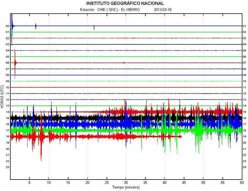
image source
By my count, that's over 60 earthquakes in the last few hours. Most are in the mid 2 magnitude range, between 16 and 21 kms deep.
Keep an eye on the action here: www.ign.es...
Earthquake-Report always does a good job reporting, too.
Let's see what develops...
image source
By my count, that's over 60 earthquakes in the last few hours. Most are in the mid 2 magnitude range, between 16 and 21 kms deep.
Keep an eye on the action here: www.ign.es...
Earthquake-Report always does a good job reporting, too.
Let's see what develops...
edit on 3/18/2013 by Olivine because: trying to fix wonky formatting
Mount Lokon spews 2,000-meter-high ash clouds
The Jakarta Post, Manado | Archipelago | Wed, March 20 2013, 12:59 PM
The Jakarta Post, Manado | Archipelago | Wed, March 20 2013, 12:59 PM
Mount Lokon in Tomohon City, North Sulawesi, erupted again at around 7:57 a.m., local time, on Wednesday, sending a plume of ash 2,000 meters into the sky from its Tompaluan crater.
“There was an increase in volcanic tremors which culminated in an eruption,” said Farid Ruskanda Bina, head of Mount Lokon and Mount Mahawu observation post at the Bandung Geology Agency’s volcanology and geological disaster mitigation center (PVMBG), in Kakaskasen, Tomohon, on Wednesday, as quoted by Antara news agency.
Warno, an official at the observation post, added that the increases in Mount Lokon’s volcanic tremors was actually not too significant.
Currently, the agency’s PVMBG is still maintaining Mount Lokon’s volcanic activity status at “alert” (level 3) although the frequency of the volcano’s eruptions has continued to decline. Previously, Mount Lokon erupted two to three times a week.
The eruption on Wednesday morning shocked local residents living around Mount Lokon as it was accompanied by loud bangs. People left their homes and crowded the Tomohon-Manado main road as well as roads in Kinilow sub-district in Kinilow Satu, Kakaskasen, to witness the eruption.
Mount Lokon has been active since July 2011. Its volcanic activity status was once raised to “awas” or level 4, until it was lowered to its current level, said Farid.
He said Mount Lokon's most recent eruption before it erupted again this morning was on March 10.
www.thejakartapost.com...
edit on 3/20/2013 by this_is_who_we_are because: typos
Originally posted by shrevegal
reply to post by Nidwin
Well, I just moved from Wyoming back to Louisiana. Fracking was/is taking place near Yellowstone area. Not only that, there are numerous areas in Wyoming and the Dakotas where uranium mines have been left. The mining was done and no clean up of the areas has taken place. The mines are left as is, and the uranium particles are left "blowin in the wind", so to speak. The winds in Wyoming are very powerful and I hate to think of the consequences involved. One of the reasons we left there was we hardly ever met a person there that was not suffering from Cancer. Those uranium mines should have been delt with but were not. Much as the problems here in Louisiana. Camp Minden here in NW Louisiana still has over 3 million pounds of explosives not being delt with properly yet. Erin Brockovich visited Bayou Corne in Southern Louisiana, as well, and mentioned the danger of explosion to that area also and how the locals are in dire need of assistance...not much being done there as yet either.
I will try and find where I heard about the plans for fracking in and around Yellowstone. TPTB are just stupid enough to drill into it. I should have said "near" Yellowstone but I'm sure I read they will be actualy drilling close/into the stupid thing. Yes, if that sucker blows for whatever reason, manmade or otherwise, we can all kiss our "hienies" good-bye, for sure! There was/is a lot of siesmic activity there as it is because that is normal to occur around volcanoes and fiddling around even just close by will be looking for trouble I think. We lived in a small town called Waipiti, near the Park entrance. I can say first hand, it is a mess up there. That place is bad news because of all that transpires there by greedy mining companies/fracking and more. When we moved to Wyoming, I was picturing pretty, woodsey landscapes...instead, it is a burned out mess in a lot of the area. The Dakotas have been ruined. The Black Hills, uranium mines left a mess. Sad but true. Lots more going on in that area then people are aware of. I wouldn't be surprised if fracking companies were to drill right into the sucker, (Yellowstone). They have been drilling in/around the GOM where ancient volcanoes exist. They do it without a care...until something goes wrong...hence, BP looking into why siesmic activity and why it is a concern relavant to the GOM. We will see. Louisiana is just a likely to "blow" as well. If the New Madrid goes off, we can kiss our "tutus" good-bye as well.
Are they that freaking stupid? the whole damn park is unstable as my sanity or whats left of it ..
well folks i guess we should start to see moderite to large quakes in this area again,, fairly soon if not a minor volcanic eruption as well. not the whole thing mind you but a minor one like the one in Hawwi.
Hello all
Just want to show you something that might be very interesting to watch in the next days :
earthquake-report.com...
Just want to show you something that might be very interesting to watch in the next days :
The National Commissioner of the Icelandic Police (NCIP) and the Police commissioner at Hvolsvöllur declare an uncertainty phase (lowest level of warning), because of seismic activity in mount Hekla
The Icelandic Met Office has informed the Civil Protection and Emergency Management of NCIP about unusual seismic activity in mount Hekla.
Hekla is one of Iceland’s most active volcanoes; over 20 eruptions have occurred in and around the volcano since 874.
During the Middle Ages, Europeans called the volcano the “Gateway to Hell.”
The volcano has produced one of the largest volumes of lava of any in the world in the last millennium, around 8 km3.
earthquake-report.com...
Been watching Hekla webcam almost whole day, that sure if majestic volcano, specially when its lit by sunlight. I saw even small plane flying around.
Hekla is known as volcano, that erupts without any warnings. It could be at pre-eruption calm phase now, when magma is flowing to its interior from the depths. Deep quakes some time ago were the sign that magma is finding its way to chamber under the volcano.
Hekla is also known as volcano which can cause strong eruptions, from VEI4 to VEI5. Last time it erupted during spring of 2000, when it was VEI3 eruption.
Small remote controlled aircraft used to detect poisonous volcanic gases in Costa Rica's Turrialba volcano.
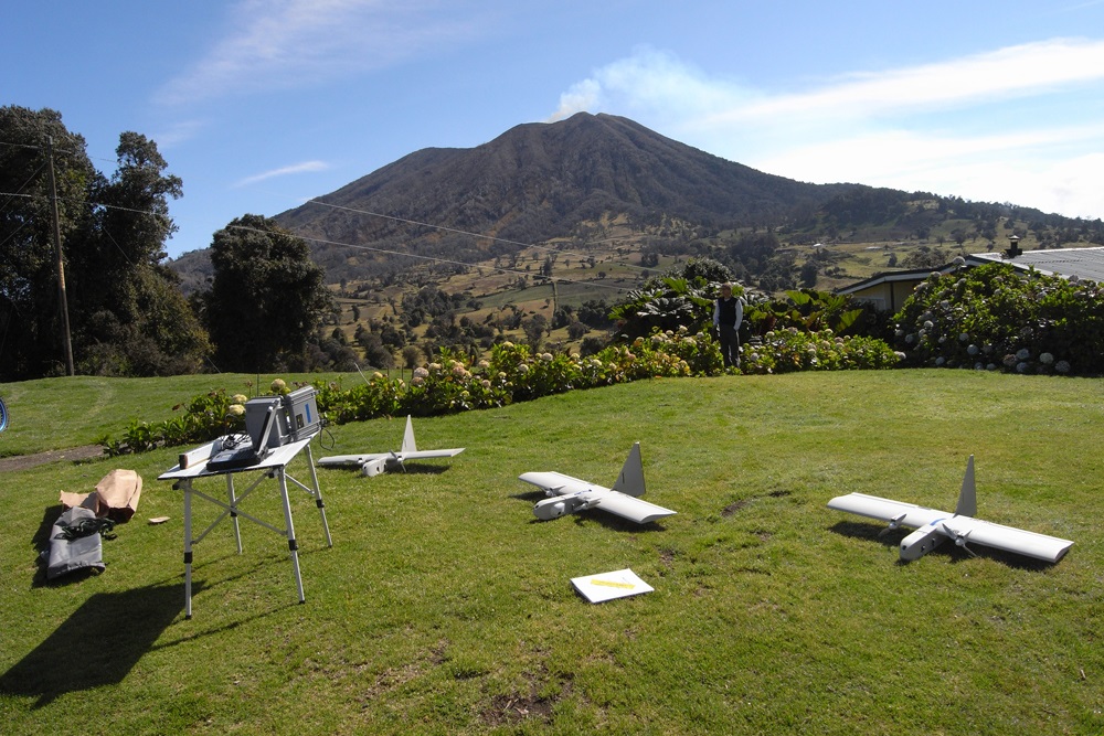
Link: www.ouramazingplanet.com...
Link: www.ouramazingplanet.com...
Sabancaya (Perú) - Report for 27 March-2 April 2013 -
NEW
500 quakes a day!! Mm. Makes some other volcanic regions seem small fry!
In an Instituto Geofísico de Perú (IGP) report, a photo showed a fumarolic plume rising above Sabancaya on 8 March. During the third week of March, a bluish colored plume rose 500 m above the crater, possibly indicating sulfur dioxide emissions. On 25 March the seismic network detected a continuing high rate of volcano-tectonic (VT) earthquakes and an increasing number of long-period (LP) events. On 27 March and 1 April VT earthquakes continued to be dominant and located below the NE sector of the crater. The number and amplitude of LP events did not change. Previously, residents of Sallalli, 11 km S of Sabancaya, reported that fumarolic activity had increased on 5 December 2012. Four earthquakes within 15 km of the crater during 22-23 February caused damage in Maca, 20 km NE. In response, the Instituto Geofísico de Perú (IGP) installed seismic stations and recorded hundreds of earthquakes per day. INGEMMET also installed monitoring equipment, and in partnership with IGP increased monitoring efforts. On 27 February scientists observed that the emissions were mostly water vapor, carbon dioxide, and sulfur dioxide. During 28 February-5 March there were 400-500 earthquakes per day recorded, mostly volcano-tectonic events.
Sources: Instituto Geofísico de Perú (IGP), Instituto Geológical Minero y Metalúrgico (INGEMMET)
500 quakes a day!! Mm. Makes some other volcanic regions seem small fry!
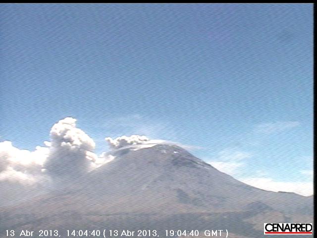
www.cenapred.gob.mx...
The only reason the ash cloud is not filling the sky is that the winds are so strong. I don't think it's blowing toward Mexico City.
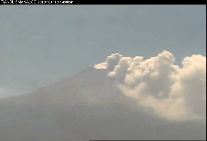
edit on 13-4-2013 by ericblair4891 because: (no reason given)
new topics
-
This is our Story
General Entertainment: 9 minutes ago -
President BIDEN Vows to Make Americans Pay More Federal Taxes in 2025 - Political Suicide.
2024 Elections: 2 hours ago -
Ode to Artemis
General Chit Chat: 3 hours ago -
Ditching physical money
History: 6 hours ago -
One Flame Throwing Robot Dog for Christmas Please!
Weaponry: 6 hours ago -
Don't take advantage of people just because it seems easy it will backfire
Rant: 7 hours ago -
VirginOfGrand says hello
Introductions: 8 hours ago -
Should Biden Replace Harris With AOC On the 2024 Democrat Ticket?
2024 Elections: 8 hours ago -
University student disciplined after saying veganism is wrong and gender fluidity is stupid
Education and Media: 11 hours ago
top topics
-
Hate makes for strange bedfellows
US Political Madness: 16 hours ago, 20 flags -
University student disciplined after saying veganism is wrong and gender fluidity is stupid
Education and Media: 11 hours ago, 12 flags -
Police clash with St George’s Day protesters at central London rally
Social Issues and Civil Unrest: 14 hours ago, 9 flags -
President BIDEN Vows to Make Americans Pay More Federal Taxes in 2025 - Political Suicide.
2024 Elections: 2 hours ago, 8 flags -
TLDR post about ATS and why I love it and hope we all stay together somewhere
General Chit Chat: 14 hours ago, 7 flags -
Should Biden Replace Harris With AOC On the 2024 Democrat Ticket?
2024 Elections: 8 hours ago, 6 flags -
Don't take advantage of people just because it seems easy it will backfire
Rant: 7 hours ago, 4 flags -
One Flame Throwing Robot Dog for Christmas Please!
Weaponry: 6 hours ago, 4 flags -
God lived as a Devil Dog.
Short Stories: 12 hours ago, 3 flags -
Ditching physical money
History: 6 hours ago, 3 flags
active topics
-
Lawsuit Seeks to ‘Ban the Jab’ in Florida
Diseases and Pandemics • 29 • : Cre8chaos79 -
TLDR post about ATS and why I love it and hope we all stay together somewhere
General Chit Chat • 8 • : Cre8chaos79 -
This is our Story
General Entertainment • 0 • : BrotherKinsMan -
New whistleblower Jason Sands speaks on Twitter Spaces last night.
Aliens and UFOs • 46 • : baablacksheep1 -
Hate makes for strange bedfellows
US Political Madness • 38 • : Terpene -
British TV Presenter Refuses To Use Guest's Preferred Pronouns
Education and Media • 126 • : Asher47 -
Why to avoid TikTok
Education and Media • 17 • : mooncake -
The Superstition of Full Moons Filling Hospitals Turns Out To Be True!
Medical Issues & Conspiracies • 22 • : mooncake -
University student disciplined after saying veganism is wrong and gender fluidity is stupid
Education and Media • 23 • : BigDuckEnergy -
President BIDEN Vows to Make Americans Pay More Federal Taxes in 2025 - Political Suicide.
2024 Elections • 3 • : BingoMcGoof