It looks like you're using an Ad Blocker.
Please white-list or disable AboveTopSecret.com in your ad-blocking tool.
Thank you.
Some features of ATS will be disabled while you continue to use an ad-blocker.

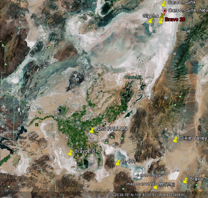
Recent Glyphs at Fallon, Nevada
page: 2share:
Using the website for NAS Fallon,
specificallyTHIS page, I mapped out the various
ranges. The "glyphs" are located in range Bravo-20.
From the website:
So, I'm thinking they are some of those geometric metal targets they are talking about.
From the website:
Bravo-20. The B-20 target range is located in the northeastern section of the Carson Sink and lies within the Lone Rock NSAWC working area. Lone Rock, an igneous rock formation approximately 140 feet tall, is the center of this target area. The B-20 area is 31 nm north-northeast of NAS Fallon at an elevation of 4,040 feet at Lone Rock. The adjacent flats are at 3,890 feet above MSL. Drainage in the area surrounding this range is very poor, often leading to extensive areas of shallow surface water surrounding many of the target sites after heavy rains. The Light Inert Impact Areas within B-20 include: • Two conventional bull’s-eye targets with night lighting and WISS scoring • Laser evaluation capabilities • A laser-guided bomb target • Two strafe targets • A submarine target • A broadcasting facility • A radar van target • Area 52, a simulated Weapons of Mass Destruction (WMD) facility The Heavy Inert Impact Area within B-20 consists of an industrial site comprised of 22 large metal targets of various geometric designs. Adjacent to the Heavy Inert Impact Area is the Live Impact Area, which includes the Lone Rock target within an alkali flat, and the Hellfire target, a single, light-armored vehicle target. The primary ordnance jettison area at Fallon is the B-20 HE impact area. The five Laser Target Areas (LTAs) aboard B-20 include the Live Impact Area, a submarine target, a laser-guided bull, and the North and South Conventional Bull targets. Delivery of inert Joint Direct Attack Munition (JDAM) is only authorized within the boundaries of the B-20 target range. The only authorized target for practice JDAM expenditure is the radar van target (B-20-12), which includes Sheridan Tank-1, Sheridan Tank-2, Sheridan Tank-3, and the Tactical Fuel Truck. The targets within B-20 accommodate expenditure of MK-76/BDU-33, MK-106, BDU-48, LGTR, 2.75 FFAR (practice), LUU-2 Paraflares, BDU-45, .20mm TP, .25mm TP, 30mm TP, 7.62mm, .50 cal (no HEI), 5.0 Zuni (practice), MK-80 series (live and practice LGB), MK-77 (Napalm), JDAM, and AGM-114 (Hellfire).
So, I'm thinking they are some of those geometric metal targets they are talking about.
reply to post by JJRichey
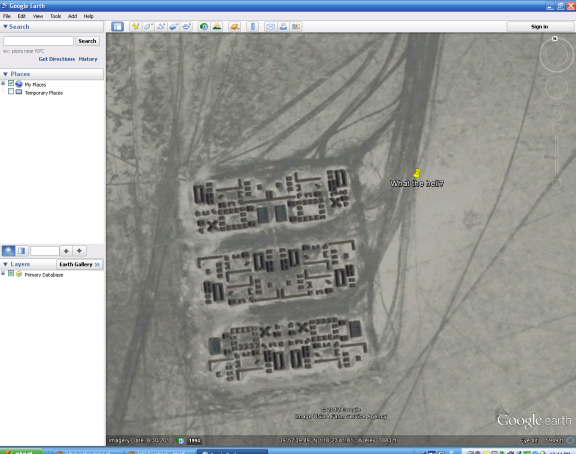
The website declares there are 22 metal targets. If these 3 large intricate composite objects are what they are talking about, there appear to be a lot more than that number. An old tank or two, or misc. equipment I can understand as targets for practice but these objects which have been there since at least 5/2006 appear to be pristine with no damage or disorder.
If I were the military and wanted to keep a bombing range off limits and secure why would I describe in detail the targets and uses of the various ranges on a web site? Is Homeland Security that comfortable with that amount of information available to the public?
reply to post by grayeagle
There are 22 METAL targets. The rest are wooden buildings, etc. Not all the targets on the range are metal, since not all the buildings they'll hit are metal. They use wood, to see how the bombs will react with different types of structures.
There are 22 METAL targets. The rest are wooden buildings, etc. Not all the targets on the range are metal, since not all the buildings they'll hit are metal. They use wood, to see how the bombs will react with different types of structures.
reply to post by Zaphod58
I see no evidence of damage to these objects from bombs or from straffing. The military will do what it will but I really question if this is a life weapons target. I will probably never know the truth and I can live with that but can you state that it doesn't look odd? I asked JJ Ritchey to tell me how similar these were to what he experienced and he has not replied.
They use wood, to see how the bombs will react with different types of structures.
I see no evidence of damage to these objects from bombs or from straffing. The military will do what it will but I really question if this is a life weapons target. I will probably never know the truth and I can live with that but can you state that it doesn't look odd? I asked JJ Ritchey to tell me how similar these were to what he experienced and he has not replied.
edit on 06/02/2011 by grayeagle because: (no reason given)
reply to post by grayeagle
There is no visible damage, but it's cheaper and faster to build with wood, than to build all the targets out of metal. Especially when you're talking about a lot of buildings like this shows.
There is no visible damage, but it's cheaper and faster to build with wood, than to build all the targets out of metal. Especially when you're talking about a lot of buildings like this shows.
reply to post by Zaphod58
So you believe they are wooden buildings? You have looked at the image? What village, urban city does this represent? Look I am an American, Navy veteran, and an adult. I know when I am being fed BS. I don't know what it is but it is very uniquely arranged with great precision and maintained that way since 5/2006. So I will let it lie to someones relief. I bit of mystery unsolved!
So you believe they are wooden buildings? You have looked at the image? What village, urban city does this represent? Look I am an American, Navy veteran, and an adult. I know when I am being fed BS. I don't know what it is but it is very uniquely arranged with great precision and maintained that way since 5/2006. So I will let it lie to someones relief. I bit of mystery unsolved!
reply to post by grayeagle
I've seen several target ranges that didn't make sense, but I agree, we'll just leave this one as another mystery unsolved, until someone can dig deeper into it and possibly figure out what it is.
I've seen several target ranges that didn't make sense, but I agree, we'll just leave this one as another mystery unsolved, until someone can dig deeper into it and possibly figure out what it is.
REALLY!?!?! my post abou tit looking like space invaders was removed? after all the stupid stuff i have seen posted and left MY post that was injected
as a source of humor in an otherwise dry thread was removed. I think maybe I need to go and reread the T&C......................I apologize to the OP
if my post offended in anyway.
reply to post by sempul
You never offended me. I appreciate humor! I personally have decided not to pursue any more comments because I felt the last couple posts were trying to basically make it go away. I asked them direct questions and neither one was willing to respond.
You never offended me. I appreciate humor! I personally have decided not to pursue any more comments because I felt the last couple posts were trying to basically make it go away. I asked them direct questions and neither one was willing to respond.
Originally posted by grayeagle
reply to post by JJRichey
The website declares there are 22 metal targets. If these 3 large intricate composite objects are what they are talking about, there appear to be a lot more than that number. An old tank or two, or misc. equipment I can understand as targets for practice but these objects which have been there since at least 5/2006 appear to be pristine with no damage or disorder.
If I were the military and wanted to keep a bombing range off limits and secure why would I describe in detail the targets and uses of the various ranges on a web site? Is Homeland Security that comfortable with that amount of information available to the public?
Sorry for taking so long to respond, as I do have a life outside of ATS Anyways, in regards to their being more than 22 targets... I doubt the website is updated all that often. As for the strange layout of the targets... I really can't say. Perhaps the shape is very specific to test calibrated equipment such as targeting, etc. As for why the ranges are off limits but pictures are easily available online as well as what the ranges are for; the ranges are offlimits because they are live ordnance ranges. We wouldn't want some hiker walking into a live range now would we?
The military does all sorts of things that don't really make sense. I had to go around the ITC at Camp Fallujah and pick up rocks w/ some fellow Marines. Why? Busy work So just becuase something looks strange, out of place, etc. doesn't make it extraordinary. Just...strange.
Anyways, sorry for my ramblings. I don't think its anything extra special. Just strange. Believe what you will
grayeagle
...You can see the tire tracks of the equipment that brought the items to their position and arranged them in this particular manner. It is the pinpoint placement and unusual appearance that have peaked my curiosity. Any ideas what it may be?
Here are the glyphs from Google Earth.
Hey, grayeagle
I saw this thread back when it was opened... Thought it interesting, but hadn't anything intelligent to add...
However, tonight, when zooming over the Western USA (in a spaceship, no less), I happened to notice this configuration...and... ...and...
...I don't know what else...but, each of the 'arrangements' prominently displays what I believe is the equivalent of "H2O"... Each, with a small but distinguishable "H" and two smaller (undiscernable) designators, and a Large and Lonesome "O".
Won't go past that - but, in a dry lake bed (presumably)... Advertising "water" ...?
ETA: Forgot to mention that the 'installation' wasn't there in October, 2006, but was in September, 2011.
edit on 2/18/2014 by WanDash because:
that's all folks
originally posted by: grayeagle
I know there has been a previous thread about this topic but I believe it deserves a second look out of curiosity. I am making absolutely no claims other than it is on a Naval Air Station bombing range near Fallon, Nevada. You can see the tire tracks of the equipment that brought the items to their position and arranged them in this particular manner. It is the pinpoint placement and unusual appearance that have peaked my curiosity. Any ideas what it may be?
Here are the glyphs from Google Earth.
What you are seeing is the B-20-18 North Military Operations in Urban Terrain (MOUT) area located at Fallon Ranges.
Every single building in that MOUT (Bldg-01 to Bldg-212) are listed by coordinates in the Fallon Range Training Complex (FRTC) Users Manual. The facility is used for urban warfare training.
Boundaries:
North West Corner
39 52.7656 N 118 23.9796 W
North East Corner
39 52.7654 N 118 23.8114 W
South West Corner
39 52.6009 N 118 23.9800 W
South East Corner
39 52.6006 N 118 23.8119 W
uchisworld.files.wordpress.com...
new topics
-
Ditching physical money
History: 1 hours ago -
One Flame Throwing Robot Dog for Christmas Please!
Weaponry: 2 hours ago -
Don't take advantage of people just because it seems easy it will backfire
Rant: 2 hours ago -
VirginOfGrand says hello
Introductions: 3 hours ago -
Should Biden Replace Harris With AOC On the 2024 Democrat Ticket?
2024 Elections: 3 hours ago -
University student disciplined after saying veganism is wrong and gender fluidity is stupid
Education and Media: 6 hours ago -
Geddy Lee in Conversation with Alex Lifeson - My Effin’ Life
People: 7 hours ago -
God lived as a Devil Dog.
Short Stories: 7 hours ago -
Police clash with St George’s Day protesters at central London rally
Social Issues and Civil Unrest: 9 hours ago -
TLDR post about ATS and why I love it and hope we all stay together somewhere
General Chit Chat: 10 hours ago
top topics
-
Hate makes for strange bedfellows
US Political Madness: 12 hours ago, 18 flags -
Who guards the guards
US Political Madness: 15 hours ago, 13 flags -
University student disciplined after saying veganism is wrong and gender fluidity is stupid
Education and Media: 6 hours ago, 11 flags -
Police clash with St George’s Day protesters at central London rally
Social Issues and Civil Unrest: 9 hours ago, 8 flags -
TLDR post about ATS and why I love it and hope we all stay together somewhere
General Chit Chat: 10 hours ago, 7 flags -
Should Biden Replace Harris With AOC On the 2024 Democrat Ticket?
2024 Elections: 3 hours ago, 5 flags -
Has Tesla manipulated data logs to cover up auto pilot crash?
Automotive Discussion: 16 hours ago, 3 flags -
One Flame Throwing Robot Dog for Christmas Please!
Weaponry: 2 hours ago, 2 flags -
Don't take advantage of people just because it seems easy it will backfire
Rant: 2 hours ago, 2 flags -
Geddy Lee in Conversation with Alex Lifeson - My Effin’ Life
People: 7 hours ago, 2 flags
active topics
-
Hate makes for strange bedfellows
US Political Madness • 36 • : Solvedit -
Don't take advantage of people just because it seems easy it will backfire
Rant • 4 • : VirginOfGrand -
Ditching physical money
History • 10 • : annonentity -
The Superstition of Full Moons Filling Hospitals Turns Out To Be True!
Medical Issues & Conspiracies • 21 • : VirginOfGrand -
-@TH3WH17ERABB17- -Q- ---TIME TO SHOW THE WORLD--- -Part- --44--
Dissecting Disinformation • 633 • : Justoneman -
VirginOfGrand says hello
Introductions • 1 • : VirginOfGrand -
Candidate TRUMP Now Has Crazy Judge JUAN MERCHAN After Him - The Stormy Daniels Hush-Money Case.
Political Conspiracies • 740 • : matafuchs -
Should Biden Replace Harris With AOC On the 2024 Democrat Ticket?
2024 Elections • 33 • : BernnieJGato -
Gold and silver prices....woo hoo
History • 84 • : annonentity -
The Democrats Take Control the House - Look what happened while you were sleeping
US Political Madness • 108 • : Zanti Misfit