It looks like you're using an Ad Blocker.
Please white-list or disable AboveTopSecret.com in your ad-blocking tool.
Thank you.
Some features of ATS will be disabled while you continue to use an ad-blocker.

Problems along the Mississippi river, a firsthand photo account.
page: 4share:
reply to post by Raist
Low water on Mississippi River good for some wildlife, bad for others
Link
The article you linked to has much more information. From what I have seen, most birds will relocate and do much better than fish when water levels change. However, fish (some of them) can be replaced. Fish will usually take much longer to recover after a drought. I also wonder how this is affecting other animals who live near the river, and also animals who may need fish or birds for food.
I do not like to see pictures of areas that are dried up with dead wildlife and foliage.
I have seen things like that too much lately, so I will just hope that the only dead fish will be pest fish.
And yes, the news lately seems to be very quiet about changes, either man made or natural, that are happening to the environment, things that affect the water, wildlife, commerce, and causing other issues too!......
Low water on Mississippi River good for some wildlife, bad for others
Low water levels on the Mississippi River are presenting challenges for some fish while benefiting other wildlife, experts say.
The impact on wildlife varies greatly, driving some fish out of normally safe areas but allowing some animals to thrive along sandbars and side channels exposed by the low water level.
Link
The article you linked to has much more information. From what I have seen, most birds will relocate and do much better than fish when water levels change. However, fish (some of them) can be replaced. Fish will usually take much longer to recover after a drought. I also wonder how this is affecting other animals who live near the river, and also animals who may need fish or birds for food.
I do not like to see pictures of areas that are dried up with dead wildlife and foliage.
I have seen things like that too much lately, so I will just hope that the only dead fish will be pest fish.
And yes, the news lately seems to be very quiet about changes, either man made or natural, that are happening to the environment, things that affect the water, wildlife, commerce, and causing other issues too!......
edit on 19-12-2012 by PacificBlue because: grammar
reply to post by sqorpius
If I am not working I will do my best to get photos when and if they blast.
I am going to try and do some updated photos and/or river levels while things persist.
I really hope something good comes from this. I am not sure if the economy and ecosystem can handle the river getting so low it closes.
Raist
reply to post by PacificBlue
Most of the birds seem fine at least those I am used to seeing. Raccoons are very active there I seen tons of their tracks.There are also plenty of big deer doing well it seems also some of the prints I seen are huge.
I would like to see some invasive species die out but they will likely thrive in this. I do worry about the sturgeon population though and how they will do as well as some of the larger fish eating all the tiny fish that normally have more places to hide.
Raist
these barge rigs look similar to the the rig set ups in alaska used to dig gold out of the bay floor where they then take the rubble away and sieve it
for gold.
reply to post by repeatoffender
That is interesting. I had no idea they did that.
They do look very similar.
Raist
That is interesting. I had no idea they did that.
They do look very similar.
Raist
I live along the Mississippi River, in eastern Iowa. Because it's getting cold out, we don't notice it as much, but we're still in severe drought
conditions here as well. The barges are traveling extremely light and high in the water, instead of full and riding low like usual. It's definitely
affecting river transit here, and there's no immediate end in sight.
I appreciate seeing your photos. Lots to be concerned about.
I appreciate seeing your photos. Lots to be concerned about.
Those first few photos of the sand bars and the banks of the river were telling. Where'd the water go? I know in times of drought in California, the
farms in Central Valley eat up all the available water and sometimes the reservoirs around here look like that late in the year. Surely the biggest
problem is transport, like you say. If they are dredging the river bottom to make it deeper, that might explain the barges. The buckets on cranes for
that are huge. They would move along the channel in the deepest part, making the river passable for traffic. Other platforms look like pile drivers of
some kind.
Good fossil hunting among the rocks and sand bars I'll bet?
Good fossil hunting among the rocks and sand bars I'll bet?
reply to post by Raist
As far as I can tell, they are dredging at a time of year to minimize potential impacts to fish breeding/rearing habitat. OP - you really should talk to the US Army Corps of Engineers project manager for this activity. I know ATS frowns upon information from gov't agencies but USACE scientists have a lot of knowledge of the existing natural systems that they are studying/managing. Not sure who the USACE project manager would be for this effort in your area, but if you have any patience for a bureaucratic phone tree, you should be able to find someone. Why don't you try Googling "Mississippi River" + "South Dakota" + "USACE" and see what you come up with?
As far as I can tell, they are dredging at a time of year to minimize potential impacts to fish breeding/rearing habitat. OP - you really should talk to the US Army Corps of Engineers project manager for this activity. I know ATS frowns upon information from gov't agencies but USACE scientists have a lot of knowledge of the existing natural systems that they are studying/managing. Not sure who the USACE project manager would be for this effort in your area, but if you have any patience for a bureaucratic phone tree, you should be able to find someone. Why don't you try Googling "Mississippi River" + "South Dakota" + "USACE" and see what you come up with?
Great lakes water levels are down too. I live in southern Michigan we didn't have a winter last year. The lakes in my area didn't freeze. We had
almost no snow. I didn't get to go ice fishing last year. This year has been warm too. Usually I'm ice fishing by Christmas and there's no ice yet
again. I'm wondering if winter will show up?
I live near some dams that supplied city water. Many many years ago they were at critical level and global warming (sorry.. climate change) was to
blame they said. "It's proof of it and they will be dry inside a decade".
They have been full and overflowing for the last 20 years.
Go figure!
But the Mississippi,well that a big river. has anyone historical records on previous dry's?
They have been full and overflowing for the last 20 years.
Go figure!
But the Mississippi,well that a big river. has anyone historical records on previous dry's?
edit on 20-12-2012 by pacifier2012 because: (no
reason given)
Raist you are to be commended highly for your most excellent photo-documentation of hopefully a once in a lifetime event.
You are quite right to be concerned.
I used to live on a river in NW Florida, and while we didn't have barge traffic up where we were, that river fed a bay which was part of the inter-coastal waterway, which had a ton of barge traffic. I also remember when the Apalachicola River got so low that they had to stop barge traffic on it. There was a lot of PO people. Apalachicola Bay is a huge fishing/oyster bay, so not only did it affect the barges, but also the seafood and tourism industry. Atlanta uses that upper basin as a water source so Geogia and Florida were fighting it out over water rights.
Now I live in SC, just south of Charlotte, NC and our county's (and other surrounding county's) drinking water comes from the Catawba River. There was a huge stink about interbasin transfers - Charlotte wanted to take huge amounts of water out of the Catawba basin, use it, then process it, then pipe it to a totally different river basin, meaning once the water was taken out of the Catawba it wasn't ever coming back. And this was during the time we were going thru a severe drought. SC said no way Jose and took NC to court over it. The same thing is happening btwn GA/SC over the Savannah River.
The Catawba feeds down into the Santee Lakes, which are man made lakes with yet another dam; the water got so low that you could see the old grave sites (revolutionary war era) that were inundated with water when the lakes were made were. Some fools were even arrested for grave robbing ---ewww!
The Catawba has a lot of dams on it for power generation and also a couple of nuke plants. There was some concern about lake levels during the drought b/c the nuke plants have to have a minimum lake level maintained to keep those rods cooled or they have to shut down; on the other side of the fence federal regs said they have to release x amount of water thru the dams to maintain the health of the river downstream & drinking water quality downstream. Hellva quandry. I notice that you guys don't have to worry about the nuke factor! That's good.
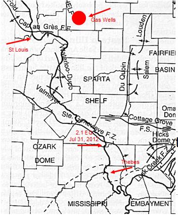
Hold on to your hat. While the grandaddy New Madrid/reelfoot fault system is just south of you and you don't have any faults in your immediate vicinity, but upriver, between you at Thebes and St Louis, there are 4 faults that cross the Mississippi River.
Sources:
Faults
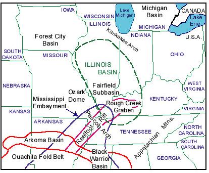
NEW ALBANY SHALE PETROLEUM SYSTEM, ILLINOIS BASIN
There are also gas wells up near St. Louis, but it lookslike they've been in production since the '90s, don't think they're fracking, but don't know for sure, things can change.
There was a 2.1 EQ in July 31 2012, real close to the river up near Grand Tower Island, looks like just a wee bit south of Ste Genevieve Fault Zone. Long/Lat co-ord:37.601 -89.534
You're in an interesting geological area, where 4 or so geological formations come together.
And also 4 different types of aquifers come together. The feeder creeks are dry, water upstream is being held, so my question is how's the aquifers doing? Heard of anyone having problems with their wells? What is the health of the trees? I know when we had our drought in SC the trees took a major hit.
Again, thanks for the pics.
You are quite right to be concerned.
I used to live on a river in NW Florida, and while we didn't have barge traffic up where we were, that river fed a bay which was part of the inter-coastal waterway, which had a ton of barge traffic. I also remember when the Apalachicola River got so low that they had to stop barge traffic on it. There was a lot of PO people. Apalachicola Bay is a huge fishing/oyster bay, so not only did it affect the barges, but also the seafood and tourism industry. Atlanta uses that upper basin as a water source so Geogia and Florida were fighting it out over water rights.
Now I live in SC, just south of Charlotte, NC and our county's (and other surrounding county's) drinking water comes from the Catawba River. There was a huge stink about interbasin transfers - Charlotte wanted to take huge amounts of water out of the Catawba basin, use it, then process it, then pipe it to a totally different river basin, meaning once the water was taken out of the Catawba it wasn't ever coming back. And this was during the time we were going thru a severe drought. SC said no way Jose and took NC to court over it. The same thing is happening btwn GA/SC over the Savannah River.
The Catawba feeds down into the Santee Lakes, which are man made lakes with yet another dam; the water got so low that you could see the old grave sites (revolutionary war era) that were inundated with water when the lakes were made were. Some fools were even arrested for grave robbing ---ewww!
The Catawba has a lot of dams on it for power generation and also a couple of nuke plants. There was some concern about lake levels during the drought b/c the nuke plants have to have a minimum lake level maintained to keep those rods cooled or they have to shut down; on the other side of the fence federal regs said they have to release x amount of water thru the dams to maintain the health of the river downstream & drinking water quality downstream. Hellva quandry. I notice that you guys don't have to worry about the nuke factor! That's good.
reply to post by Raist
Unless it [fault] is directly under the river I have not seen anything.
Hold on to your hat. While the grandaddy New Madrid/reelfoot fault system is just south of you and you don't have any faults in your immediate vicinity, but upriver, between you at Thebes and St Louis, there are 4 faults that cross the Mississippi River.
Sources:
Faults
NEW ALBANY SHALE PETROLEUM SYSTEM, ILLINOIS BASIN
There are also gas wells up near St. Louis, but it lookslike they've been in production since the '90s, don't think they're fracking, but don't know for sure, things can change.
There was a 2.1 EQ in July 31 2012, real close to the river up near Grand Tower Island, looks like just a wee bit south of Ste Genevieve Fault Zone. Long/Lat co-ord:37.601 -89.534
You're in an interesting geological area, where 4 or so geological formations come together.
And also 4 different types of aquifers come together. The feeder creeks are dry, water upstream is being held, so my question is how's the aquifers doing? Heard of anyone having problems with their wells? What is the health of the trees? I know when we had our drought in SC the trees took a major hit.
Again, thanks for the pics.
I bet they don't take advantage of it though. Always worried about "Right Now" and profits for the mighty Corporations that own us.
Lemons to lemonade. Why don't they take advantage of the low levels and correct or at least cut down the Asian Carp? This is more devastating than one winter of a drought by far. They could slow down the progression of these by an extreme amount right now with little effort.
Information on this can be found everywhere. Just search flying carp. Hundreds of great Youtube vids as well.
reply to post by Raist
Well if they were not secretly sucking the Mississippi dry to use the water for fracking, there wouldn't be a problem.
Well if they were not secretly sucking the Mississippi dry to use the water for fracking, there wouldn't be a problem.
reply to post by oblivietto
Yeah, I have not seen a low sitting barge in a long time. Now it seems all of them are riding high.
Raist
Yeah, I have not seen a low sitting barge in a long time. Now it seems all of them are riding high.
Raist
reply to post by intrptr
I think the limit on barge traffic is affecting our economy now. I would hate to see it if they shut the river down.
The fossils are pretty nice with the river down. You can find quite a bit of petrified wood if you look in the right areas.
Raist
I think the limit on barge traffic is affecting our economy now. I would hate to see it if they shut the river down.
The fossils are pretty nice with the river down. You can find quite a bit of petrified wood if you look in the right areas.
Raist
I was wondering if the low level is due to low rainfall or more water being pumped from the river. Is water pumped from upriver for irrigation
purposes? If it is, have they oversold the allocations? Is the rainfall really at record lows? By selling water pumping allocations, the authorities
make more money. I cant count the number of times they have done that here. A few wet years, low prices, farmers dont use all their allocation, so
they water authority sells more, then when they all get used their isnt enough to go around. The price of water goes up and they public calls for the
governmental authority to buy back some of the water rights - at the inflated price of course. A decade or two later it starts over again.
Originally posted by Raist
reply to post by TheOtter
You would think that the national news would have been all over this sooner. I live near the river and knew it was low but I had no idea it was that serious. The water is too muddy to see how deep it is.
I follow the river levels but I do not understand how exactly they are getting their measurement. I do not believe a barge can travel on 5 feet of water when it is loaded down. I might be wrong about that but it seems to low, so their measurement must be not actual depth.
Raist
No , a loaded barge can not move on 5ft of water . They have a draft of around 10 feet give or take with two feet of freeboard (that would be what is above the water line not counting the combing of the hopper) . They need atleast a couple of feet of water between the bottom of the barge and the river bed to be safe . And you would be surprised at how easily these steel barges can rip/crack open when coming in contact with rocks , cold steel especially .
I retired from the river industry , and droughts are devastating to us . Tow boats travel the river between a buoyed channel that in places needs to be manually dredged from time to time to make sure the channel remains open .
Back in the 90's the river dropped down so low that we were stuck down near Cairo Illinois , close to where the Ohio empties into the Mississippi , because our loads (loaded barges) could not clear the seal of the locks (the seal is the bottom where the lock gates close and makes them water tight ) . We sat for more than 10 days waiting for enough rain up river to raise the water level . Companies lose money and power plants run low on coal .
The river industry is important because it is the cheapest way to move large amounts of coal , grain , fuel , oil , gravel and sand to name a few . One barge can hold (I can not remember the exact amount of train cars ) many train cars worth of materials , and it would take even more dump trucks to fill one barge . Most tow boats shove 15 loads at a time on the Ohio , and on the Mississippi some will shove 20 barges if the are triple screw boats .So instead of having hundreds of dump/semis trucks traveling the roads to move coal to power plants , it takes one boat and 15 barges to do the job .
Also , Most of these boats have steering rudders (along with flanking rudders) the size of barn doors , and the rudders can be damaged in low water , more so if they hit solid rock . And some boats are open wheeled (prop) that can also be damaged on rocks . And if these are damaged , the boat must be placed on dry dock for VERY costly repairs .
edit on 20-12-2012 by whenandwhere because: (no reason given)
edit on
20-12-2012 by whenandwhere because: (no reason given)
Originally posted by Raist
reply to post by oblivietto
Yeah, I have not seen a low sitting barge in a long time. Now it seems all of them are riding high.
Raist
These would be what we call part loads . When the river depth gets to low for full barges , they are loaded "light" and boats take on less fuel so they will have more freeboard and ride higher in the water .
reply to post by Raist
First i take it its not normal for this thing to drop this low correct?
My first thought is if that is the case maybe we dug out the river or gave it someplace to go to get ready for a intake of say lots of flooding?
I really dont have a clue. but it is one of my first thoughts
First i take it its not normal for this thing to drop this low correct?
My first thought is if that is the case maybe we dug out the river or gave it someplace to go to get ready for a intake of say lots of flooding?
I really dont have a clue. but it is one of my first thoughts
new topics
-
Any one suspicious of fever promotions events, major investor Goldman Sachs card only.
The Gray Area: 33 minutes ago -
God's Righteousness is Greater than Our Wrath
Religion, Faith, And Theology: 5 hours ago -
Electrical tricks for saving money
Education and Media: 8 hours ago -
VP's Secret Service agent brawls with other agents at Andrews
Mainstream News: 9 hours ago -
Sunak spinning the sickness figures
Other Current Events: 10 hours ago -
Nearly 70% Of Americans Want Talks To End War In Ukraine
Political Issues: 10 hours ago
top topics
-
VP's Secret Service agent brawls with other agents at Andrews
Mainstream News: 9 hours ago, 9 flags -
Cats Used as Live Bait to Train Ferocious Pitbulls in Illegal NYC Dogfighting
Social Issues and Civil Unrest: 13 hours ago, 8 flags -
Electrical tricks for saving money
Education and Media: 8 hours ago, 4 flags -
HORRIBLE !! Russian Soldier Drinking Own Urine To Survive In Battle
World War Three: 17 hours ago, 3 flags -
Sunak spinning the sickness figures
Other Current Events: 10 hours ago, 3 flags -
Nearly 70% Of Americans Want Talks To End War In Ukraine
Political Issues: 10 hours ago, 3 flags -
Late Night with the Devil - a really good unusual modern horror film.
Movies: 12 hours ago, 2 flags -
The Good News According to Jesus - Episode 1
Religion, Faith, And Theology: 15 hours ago, 1 flags -
Any one suspicious of fever promotions events, major investor Goldman Sachs card only.
The Gray Area: 33 minutes ago, 1 flags -
God's Righteousness is Greater than Our Wrath
Religion, Faith, And Theology: 5 hours ago, 0 flags
active topics
-
Terrifying Encounters With The Black Eyed Kids
Paranormal Studies • 75 • : FlyersFan -
God's Righteousness is Greater than Our Wrath
Religion, Faith, And Theology • 3 • : andy06shake -
SETI chief says US has no evidence for alien technology. 'And we never have'
Aliens and UFOs • 54 • : andy06shake -
Russia Ukraine Update Thread - part 3
World War Three • 5728 • : F2d5thCavv2 -
Electrical tricks for saving money
Education and Media • 5 • : BeyondKnowledge3 -
Nearly 70% Of Americans Want Talks To End War In Ukraine
Political Issues • 14 • : FlyersFan -
-@TH3WH17ERABB17- -Q- ---TIME TO SHOW THE WORLD--- -Part- --44--
Dissecting Disinformation • 658 • : F2d5thCavv2 -
Any one suspicious of fever promotions events, major investor Goldman Sachs card only.
The Gray Area • 0 • : Cavemannick -
Sunak spinning the sickness figures
Other Current Events • 7 • : xWorldxGonexMadx -
HORRIBLE !! Russian Soldier Drinking Own Urine To Survive In Battle
World War Three • 33 • : Degradation33