It looks like you're using an Ad Blocker.
Please white-list or disable AboveTopSecret.com in your ad-blocking tool.
Thank you.
Some features of ATS will be disabled while you continue to use an ad-blocker.

Problems along the Mississippi river, a firsthand photo account.
page: 1share:
In response to this thread that I posted a few photos from a month or so I thought I
would bring ATS a firsthand account of what is going on in at least one part of the 180 miles that are putting the river at risk of closing.
From these links it states they will start rock removal from the river in hopes to keep barge traffic moving.
www.todaystmj4.com...
www.capjournal.com...
They plan to start removing rock from Grand Tower all the way to Thebes.
At Grand Tower is a very cool rock formation in the river known as Tower Rock.
en.wikipedia.org...
I live near the river and have gone from above Grand Tower to Thebes in search of fossils. There is an amazing display of different rock age along the river. I find fossils within the rock along the river and I find petrified wood that has washed down river along the banks.
Not only is the river a great place to find fossils but it is a very important mode of transport of products. Living in the river town I do the closing of the river in this area could be a very bad thing. There are many factories in the area that chose it because of the large amount of choices of transport and being in the central U.S. for the most part. Here they can use truck, train, barge, and even air to move product of different size.
When I heard they were going to be removing rocks I became worried about the destruction of scientific and historical finds. I still worry about some things being destroyed but today I witness first hand some of the rock removal. At this point they are not blasting just using heavy equipment to move rock from the bottom of the river.
Here are a few photos I took today. After posting a few photos I will post the link to the full album with 82 photos.
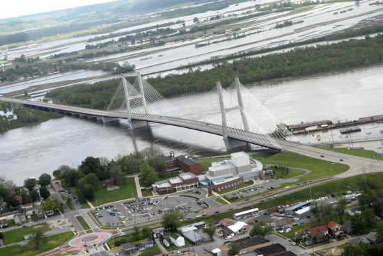
The first photos are from Cape Girardeau.
Here you can see two barges waiting as one moves past a sand bar that covers nearly half way across the river.

Here you can see the Coast Guard has put up a mobile command.

They are set up at the local boat ramp which is no longer of use.

At this point I an roughly half way out where the water of the river normally flows.

Here you can see just how close to the middle I am. While the middle is not the deepest point, you need to understand that this is supposed to be covered with several feet of water here. If I could stand in the moving water of the river the water would likely be over my 5' 8" stance at this point.
This is facing north.

This is facing west toward where I walked from the boat ramp.

And this is facing south toward the bridge.

I will now take you to Thebes. The whiter rocks (kimmswick limestone) were under water just over a month ago. I forget the name of the formation of the darker rocks, but I know it is just above the kimmswick.

This is the train bridge at Thebes. you can see where the water level normally runs on the blocks that hold up the bridge.


The rock removal has started around the Thebes area. They are removing the rock from several areas. Today they were working on over three areas at one time. Here are a few photos of how they are doing it. What you see are tug boats moving what seems to be some sort of platform that has a backhoe on it.
In this image you can just see the operations just past the rock levee. I would have gotten closer but another group of people I met got ran off by a man claiming that was his property. Which is odd since I have been there before looking for petrified wood since that is a natural catch for that sort of thing and been seen by people and not ran off, but I was not in the mood to argue that at this point.

I was in the Thebes area for over 2 hours and this boat did not move at all during that time.

Just north of the Thebes train bridge they had a backhoe loading 18 wheelers with rock. I did not see any boats deliever rocks to this area during that time, but I can only assume that some of this rock was coming from out in the river.

Here is that operation a bit closer and between trailer trucks.

Here is a quick shot of an area that should be under several feet of water.

This boat was moving a backhoe back down the river again. Earlier it had been closer to the camping area north of the train bridge. I believe it stopped just south of the train bridge and started working near the one just south of the rain bridge in the earlier photo.

Here is a closer shot of that one.

Another shot as I walked north of rocks that should be under several feet of water.

Here are some good views of exatly what they are doing.


(continued)
From these links it states they will start rock removal from the river in hopes to keep barge traffic moving.
www.todaystmj4.com...
www.capjournal.com...
They plan to start removing rock from Grand Tower all the way to Thebes.
At Grand Tower is a very cool rock formation in the river known as Tower Rock.
en.wikipedia.org...
I live near the river and have gone from above Grand Tower to Thebes in search of fossils. There is an amazing display of different rock age along the river. I find fossils within the rock along the river and I find petrified wood that has washed down river along the banks.
Not only is the river a great place to find fossils but it is a very important mode of transport of products. Living in the river town I do the closing of the river in this area could be a very bad thing. There are many factories in the area that chose it because of the large amount of choices of transport and being in the central U.S. for the most part. Here they can use truck, train, barge, and even air to move product of different size.
When I heard they were going to be removing rocks I became worried about the destruction of scientific and historical finds. I still worry about some things being destroyed but today I witness first hand some of the rock removal. At this point they are not blasting just using heavy equipment to move rock from the bottom of the river.
Here are a few photos I took today. After posting a few photos I will post the link to the full album with 82 photos.
The first photos are from Cape Girardeau.
Here you can see two barges waiting as one moves past a sand bar that covers nearly half way across the river.
Here you can see the Coast Guard has put up a mobile command.
They are set up at the local boat ramp which is no longer of use.
At this point I an roughly half way out where the water of the river normally flows.
Here you can see just how close to the middle I am. While the middle is not the deepest point, you need to understand that this is supposed to be covered with several feet of water here. If I could stand in the moving water of the river the water would likely be over my 5' 8" stance at this point.
This is facing north.
This is facing west toward where I walked from the boat ramp.
And this is facing south toward the bridge.
I will now take you to Thebes. The whiter rocks (kimmswick limestone) were under water just over a month ago. I forget the name of the formation of the darker rocks, but I know it is just above the kimmswick.
This is the train bridge at Thebes. you can see where the water level normally runs on the blocks that hold up the bridge.
The rock removal has started around the Thebes area. They are removing the rock from several areas. Today they were working on over three areas at one time. Here are a few photos of how they are doing it. What you see are tug boats moving what seems to be some sort of platform that has a backhoe on it.
In this image you can just see the operations just past the rock levee. I would have gotten closer but another group of people I met got ran off by a man claiming that was his property. Which is odd since I have been there before looking for petrified wood since that is a natural catch for that sort of thing and been seen by people and not ran off, but I was not in the mood to argue that at this point.
I was in the Thebes area for over 2 hours and this boat did not move at all during that time.
Just north of the Thebes train bridge they had a backhoe loading 18 wheelers with rock. I did not see any boats deliever rocks to this area during that time, but I can only assume that some of this rock was coming from out in the river.
Here is that operation a bit closer and between trailer trucks.
Here is a quick shot of an area that should be under several feet of water.
This boat was moving a backhoe back down the river again. Earlier it had been closer to the camping area north of the train bridge. I believe it stopped just south of the train bridge and started working near the one just south of the rain bridge in the earlier photo.
Here is a closer shot of that one.
Another shot as I walked north of rocks that should be under several feet of water.
Here are some good views of exatly what they are doing.
(continued)
I walked a few miles (4-6 in a mix of mud, sand, and rock) today to see this and get photos and wanted to share this with ATS. This is important. If
the river shuts down things will be pretty bad. A lot of money travels up and down that river daily. If the river closes the economy is really going
to be hurting. At this point the ecosystem is feeling it.
Here is a link to the full slide show of photos. There are 82 photos in total.
s383.photobucket.com...
I hope you enjoy and I hope this helps you understand more about what exactly is going on and how serious it really is.
Raist
Here is a link to the full slide show of photos. There are 82 photos in total.
s383.photobucket.com...
I hope you enjoy and I hope this helps you understand more about what exactly is going on and how serious it really is.
Raist
edit on 12/19/12 by Raist because: fixing link
Thank you for the pics and update. So is it simply drought that is causing this or something else?
Thank you for all your work and concern , I too would like to know more about this .
reply to post by Carreau
reply to post by ujustneverknow
I believe drought has played the biggest part. We get rain and upstream gets rain, just not enough.
I also sort of think that their fix for the flooding last year has helped add to this problem as well.
Last year the river was swelled well beyond the normal depth. I would have been under a great deal of water where I was standing as it went well into the tree line at Thebes at that time. Also the railroad tracks you see were under water last year as well.
We went from a large amount of flooding last year to a very dry river this year. People over twice my age are saying they never seen the river this low. I know I certainly have never seen it this low. In almost every photo where I was standing should be under water.
Raist
edit on 12/19/12 by Raist because: replying to both posters above since their questions were similar.
Awesome pics! I have family that lives not too far from Kaskaskia Island, but I haven't been over that way since Thanksgiving. The river was looking
mighty lean whenever I crossed over at Chester then. I'll ask my brother what it looks like when he comes over for Christmas.
That river always amazes me. I'll never forget the Flood of '93. It looked like an ocean looking out from Chester back then. Then you see it now and it's hard to believe it ever happened.
That river always amazes me. I'll never forget the Flood of '93. It looked like an ocean looking out from Chester back then. Then you see it now and it's hard to believe it ever happened.
Originally posted by Raist
I also sort of think that their fix for the flooding last year has helped add to this problem as well.
This would no surprise me in the least. It is a fools errand to attempt to "fix" the might Mississipp!
An article from back in August tells of salt water creeping up the river due to the low amount of water flowing down it.
www.nytimes.com...
It is amazing I had not heard this before. The local news never even brought it up. They only recently started really covering how low the river is seriously. Prior to this they would mention it from time to time but no real big stories unless someone found something or to say that you can now walk out to Tower Rock. Also back in July/August the river still was not at the historical low it was in 1988. Now though it is below that historical low so I guess they are finally paying it a bit more attention.
For someone like me this is a double edged sword though. The lower the river the more rocks I can scan for fossils. At the same time the lower it gets the more risk there is to the economy and even the ecosystem. If any good comes from this maybe it will take out some of the jumping carp population and some of the invasive muscle species that have taken hold in the river.
This article will give you a bit more information on Thebes and it being the lowest area. The ap on my phone says the river leve at Cape Girardeau (just north of Thebes) is 5.2 feet which is .07 lower than it was around 12 hours ago. It also says that the level at Thebes is 3.84 feet which is also a bit lower than it was 12 hours ago.
www.dailymail.co.uk...
They have a photo on their page from the camping ground area, but they did not go down to the rivers edge. In their photo you cannot see just how bad it really is.
Raist
www.nytimes.com...
The volume of water coming down the river is so much lower than normal this summer that a wedge of salt water is creeping up the Mississippi toward New Orleans, imperiling local water supplies drawn from the river.
It is amazing I had not heard this before. The local news never even brought it up. They only recently started really covering how low the river is seriously. Prior to this they would mention it from time to time but no real big stories unless someone found something or to say that you can now walk out to Tower Rock. Also back in July/August the river still was not at the historical low it was in 1988. Now though it is below that historical low so I guess they are finally paying it a bit more attention.
For someone like me this is a double edged sword though. The lower the river the more rocks I can scan for fossils. At the same time the lower it gets the more risk there is to the economy and even the ecosystem. If any good comes from this maybe it will take out some of the jumping carp population and some of the invasive muscle species that have taken hold in the river.
This article will give you a bit more information on Thebes and it being the lowest area. The ap on my phone says the river leve at Cape Girardeau (just north of Thebes) is 5.2 feet which is .07 lower than it was around 12 hours ago. It also says that the level at Thebes is 3.84 feet which is also a bit lower than it was 12 hours ago.
www.dailymail.co.uk...
Barge traffic on the Mississippi River could grind to a halt by the New Year because of historically low water levels.
The choke point is Thebes, Missouri, a small town outside St. Louis, where the water has dropped so low that rusting metal and other hazardous materials are being exposed by the receding river.
Farmers and shipping companies on the Mississippi, which generates $7billion in the winter months, are demanding President Barack Obama order dams on the Missouri River opened to pump more water into the Mississippi and raise the levels.
Read more: www.dailymail.co.uk...
Follow us: @MailOnline on Twitter | DailyMail on Facebook
They have a photo on their page from the camping ground area, but they did not go down to the rivers edge. In their photo you cannot see just how bad it really is.
Raist
Originally posted by Raist
reply to post by Carreau
I believe drought has played the biggest part. We get rain and upstream gets rain, just not enough.
I also sort of think that their fix for the flooding last year has helped add to this problem as well.
Last year the river was swelled well beyond the normal depth. I would have been under a great deal of water where I was standing as it went well into the tree line at Thebes at that time. Also the railroad tracks you see were under water last year as well.
We went from a large amount of flooding last year to a very dry river this year. People over twice my age are saying they never seen the river this low. I know I certainly have never seen it this low. In almost every photo where I was standing should be under water.
Raist
The tracks were underwater?
They're pretty high, man! Really!?
reply to post by Komaratzi11
Seeing the difference over the last three years is amazing. Three years ago the river was roughly average, if not a bit high at times.
Last year it was exploding out of the banks closing many roads and causing a small town to either sell their homes or no longer be covered in case of flooding. Last years flooding also caused them to blow levees in order to ease the flooding and cause water to subside.
www.nytimes.com...
Then this year we hardly have a river. Seeing the water so low nearly makes me cry. I have never seen such serious conditions on the river. Last year the flooding caused problems but nothing like this. The river pulled a complete 180 from what it was last year.
Raist
Seeing the difference over the last three years is amazing. Three years ago the river was roughly average, if not a bit high at times.
Last year it was exploding out of the banks closing many roads and causing a small town to either sell their homes or no longer be covered in case of flooding. Last years flooding also caused them to blow levees in order to ease the flooding and cause water to subside.
www.nytimes.com...
With a flash of light and a massive rumbling that shook windows miles away, the Army Corps of Engineers set off explosives at 10 p.m. along the first of several sections of the earthen barrier, sending 550,000 cubic feet of water a second across the 130,000 acres of farmland known as the spillway. There were 90 homes in the spillway, but under the cover of darkness it was impossible to gauge the initial devastation.
Then this year we hardly have a river. Seeing the water so low nearly makes me cry. I have never seen such serious conditions on the river. Last year the flooding caused problems but nothing like this. The river pulled a complete 180 from what it was last year.
Raist
reply to post by METACOMET
I think we screw up more trying to fix nature than if we would just let it fix itself.
I cannot believe this is all due to drought.
Raist
I think we screw up more trying to fix nature than if we would just let it fix itself.
I cannot believe this is all due to drought.
Raist
reply to post by samuel1990
If you know the area HWY 177 was covered as water backwashed up a creek that flows into the river. The flood gates were closed in the town of Cape Girardeau most of the year last year.
The water was over the tracks just below the park were I took the photos of the barges lined up to come down river. The rocks I stood on and that were in fron t of me in that photo were under water. The tracks you see in the photo of the barges waiting had water just over them.
Last year there was record flooding in many areas. This year it is record low water in those same areas.
Raist
reply to post by samuel1990
This photo is not mine but it shows the flooding last year.
You can see this bridge in one of my photos, most of the area flooded is East Cape which is just north of Thebes. You can get a general idea of just how much was below water at that time.
This photo (also not mine) shows the Red Star district of Cape Girardeau which is where the boat ramp is at that now cannot be used.

Here is a link to 74 photos of the flooding at that time and a lot of the places it affected.
www.semissourian.com...
Edit to add: the railroad tracks are under water at the Red Star district in that photo.
Raist
This photo is not mine but it shows the flooding last year.
You can see this bridge in one of my photos, most of the area flooded is East Cape which is just north of Thebes. You can get a general idea of just how much was below water at that time.
This photo (also not mine) shows the Red Star district of Cape Girardeau which is where the boat ramp is at that now cannot be used.
Here is a link to 74 photos of the flooding at that time and a lot of the places it affected.
www.semissourian.com...
Edit to add: the railroad tracks are under water at the Red Star district in that photo.
Raist
edit on 12/19/12 by Raist because: (no reason given)
I remember when the river threatened to flood, there was all kinds of news coverage of it here, I haven't heard anything about the river being lo
tho. I live just outsdie of New Orleans and there has or was reports of the salt water creeping up the river earlier on in the summer, it was a
(kinda) big deal here. They had to start getting some people drinking water from other areas due to it, surprisingly I haven't heard anything about
the saltwater creeping up anymore tho. I went out to the river when it was "swollen" took a few pics, I haven't been out to the river in some
months, but I can't believe how dry it is from the photos you posted.
I think we caused most of it trying to prevent flooding, maybe that's why I'm not hearing anything about it.
I think we caused most of it trying to prevent flooding, maybe that's why I'm not hearing anything about it.
reply to post by WhoDat09
The slat water article I linked was from back in August so it might not still be doing that. I did not hear about it until I started looking up articles about how bad it is. I knew the river was getting really low but the seriousness of it was not really covered until now, and it seems like it is too late.
I agree that I think we helped to cause the problem by trying to stop the flooding. The drought I am sure plays a large part, but I do not believe it is the only cause.
The Mississippi has a long history. A history that has it moving in different banks west of where it now lays. The river has always changed yet it always survived, it is big enough that it is practically alive. Then we come along and try to fix and command nature and really screw things up.
Raist
With all of the glaciers and ice bergs melting away, where is the water going?? (rhetorical question, I'm not pretending to know how that science
works )
I had no idea it was this severe. Your photos speak more than words SnF.
Thanks for the first hand account and taking the time to get the word out. This is the best part of ATS (IMO), the user generated content. It's what keeps me coming back.
It has to make you wonder where the national news media is? They've also completely ignored the ecological disaster in Bayou Corne, Louisiana where the sinkhole sits, biding its time until.... ??
reply to post by TheOtter
You would think that the national news would have been all over this sooner. I live near the river and knew it was low but I had no idea it was that serious. The water is too muddy to see how deep it is.
I follow the river levels but I do not understand how exactly they are getting their measurement. I do not believe a barge can travel on 5 feet of water when it is loaded down. I might be wrong about that but it seems to low, so their measurement must be not actual depth.
Raist
I knew the drought was bad on the river, but I didn't know it was this bad. Your photos made me cry. If rivers, creeks, streams, brooks, et al
are thought of as the nation's veins & arteries, then this is like watching the main artery shrivel up
The pictures are amazing and scary too. Thank you for sharing them. I read about the low water levels and was wondering if the river was still low.
I am not very familiar with that part of the country, but I always wonder why there can be so much water one year, and then a very severe drought the next. I realize that there is a drought, but it seems like we could try to manage the water better, especially when low water will cause so many problems, both with commerce and the river environment.
There is no shortage of water here in Oregon, and this year we seem to have more than enough, so I will try to hope that some of our liquid sunshine (rain) heads your way. I realize that this is not a laughing matter, just kind of drenched this month... I will be hoping that the drought ends soon, so the river can recover.
PacificBlue
Originally posted by Raist
I agree that I think we helped to cause the problem by trying to stop the flooding. The drought I am sure plays a large part, but I do not believe it is the only cause.
The Mississippi has a long history. A history that has it moving in different banks west of where it now lays. The river has always changed yet it always survived, it is big enough that it is practically alive. Then we come along and try to fix and command nature and really screw things up.
Raist
I am not very familiar with that part of the country, but I always wonder why there can be so much water one year, and then a very severe drought the next. I realize that there is a drought, but it seems like we could try to manage the water better, especially when low water will cause so many problems, both with commerce and the river environment.
There is no shortage of water here in Oregon, and this year we seem to have more than enough, so I will try to hope that some of our liquid sunshine (rain) heads your way. I realize that this is not a laughing matter, just kind of drenched this month... I will be hoping that the drought ends soon, so the river can recover.
PacificBlue
edit on 19-12-2012 by PacificBlue because: grammar
edit on 19-12-2012 by PacificBlue because: again
reply to post by Carreau
It's the bad drought we had this past summer.Still haven't made up for the lack of water.If we get a bad winter with a lot of snow it would help in the spring to make up for it.If not it could take several years to get back to normal.
Also the corp of engineers have reduced the amount of water going down the Missouri river up stream at a damn.
www.boonvilledailynews.com...
edit on 19-12-2012 by Dimithae because: (no reason given)
new topics
-
12 jurors selected in Trump criminal trial
US Political Madness: 27 minutes ago -
Iran launches Retalliation Strike 4.18.24
World War Three: 41 minutes ago -
Israeli Missile Strikes in Iran, Explosions in Syria + Iraq
World War Three: 1 hours ago -
George Knapp AMA on DI
Area 51 and other Facilities: 6 hours ago -
Not Aliens but a Nazi Occult Inspired and then Science Rendered Design.
Aliens and UFOs: 6 hours ago -
Louisiana Lawmakers Seek to Limit Public Access to Government Records
Political Issues: 9 hours ago -
The Tories may be wiped out after the Election - Serves them Right
Regional Politics: 10 hours ago
top topics
-
BREAKING: O’Keefe Media Uncovers who is really running the White House
US Political Madness: 13 hours ago, 25 flags -
George Knapp AMA on DI
Area 51 and other Facilities: 6 hours ago, 20 flags -
Biden--My Uncle Was Eaten By Cannibals
US Political Madness: 14 hours ago, 18 flags -
Israeli Missile Strikes in Iran, Explosions in Syria + Iraq
World War Three: 1 hours ago, 8 flags -
"We're All Hamas" Heard at Columbia University Protests
Social Issues and Civil Unrest: 14 hours ago, 7 flags -
Louisiana Lawmakers Seek to Limit Public Access to Government Records
Political Issues: 9 hours ago, 7 flags -
So I saw about 30 UFOs in formation last night.
Aliens and UFOs: 12 hours ago, 5 flags -
Not Aliens but a Nazi Occult Inspired and then Science Rendered Design.
Aliens and UFOs: 6 hours ago, 3 flags -
Do we live in a simulation similar to The Matrix 1999?
ATS Skunk Works: 13 hours ago, 3 flags -
The Tories may be wiped out after the Election - Serves them Right
Regional Politics: 10 hours ago, 3 flags
active topics
-
Iran launches Retalliation Strike 4.18.24
World War Three • 7 • : Degradation33 -
Israeli Missile Strikes in Iran, Explosions in Syria + Iraq
World War Three • 17 • : YourFaceAgain -
12 jurors selected in Trump criminal trial
US Political Madness • 2 • : RazorV66 -
African "Newcomers" Tell NYC They Don't Like the Free Food or Shelter They've Been Given
Social Issues and Civil Unrest • 16 • : stelth2 -
It has begun... Iran begins attack on Israel, launches tons of drones towards the country
World War Three • 883 • : 777Vader -
-@TH3WH17ERABB17- -Q- ---TIME TO SHOW THE WORLD--- -Part- --44--
Dissecting Disinformation • 536 • : 777Vader -
Elites disapearing
Political Conspiracies • 29 • : 777Vader -
MULTIPLE SKYMASTER MESSAGES GOING OUT
World War Three • 37 • : YourFaceAgain -
Mandela Effect - It Happened to Me!
The Gray Area • 106 • : CCoburn -
Candidate TRUMP Now Has Crazy Judge JUAN MERCHAN After Him - The Stormy Daniels Hush-Money Case.
Political Conspiracies • 388 • : matafuchs