It looks like you're using an Ad Blocker.
Please white-list or disable AboveTopSecret.com in your ad-blocking tool.
Thank you.
Some features of ATS will be disabled while you continue to use an ad-blocker.

Charles Hapgoods Largely Forgetten Earth Crust Displacement Hypothesis, Iceages and Ancient Maps
page: 1share:
Just read a review of Hapgoods original paper on this. Which can be viewed at
Archive.org here. A far tidier PDF version of it
is here. The foreword is written by Einstein shortly
before his death, at a time when Alfred Wegeners 1912 theory of continental drift / plate tectonics was being ridiculed by most geologists in the
world and shunned from all eduction. Which, due to more evidence in support of it accumulating, was accepted in 1960's, and soon became the best
theory in town.
Could this Earth Crust Displacement Hypothesis be the next similar frontier in geology?
en.wikipedia.org...
(I notice the above extremely brief wiki entry lacks citations refuting his claims [rather those supporting other theories [2][3][18]], and also lacks citations supporting it too)
In a nutshell he proposes that the crust of the Earth can sometimes move conformally, in addition to plate tectonics, around the mantle. This would explain in the past how areas of the Earth like America were covered by up to 2km of ice in the previous Iceages, as back then they had been shifted into a similar position as to that of the modern day Arctic/Antarctica, for periods of possibly tens of thousands of years.
He uses other more circumstantial evidence in support of this theory too, the text is 450 pages long, and extremely in detail research.
Other links I found at the top of Google on ECD that are informative are:
Theory of Crustal Displacement
www.skrause.org...
Theory of Crustal Displacement
www.crystalinks.com...
Hapgoods wiki
en.wikipedia.org...
Again full text here, it's nearly 450 pages long:
Archive.org Main page: Eaths Shifting Crust (1958/00/00)
full text [PDF]
Brief Excerpt:
Anyone here read it? Anyone here got opinions on it?
Recent audio discussion of this theory on science friday, in which they do not really menti9on Hapgood but just propose it as a plausible theory (even though it's been around for over 60 years just largely ignored by geologists!)
sciencefriday.com...
I think this is the paper that the segment was discussing from nature, but it is framed much more in terms of conventional geology than Hapgoods theory.
Mechanisms for oscillatory true polar wander
Hapgood created his theory documenting three Earth crust displacements in the last 100,000 years. Some researchers believe that they happen every 41,000 years and that the last one happened 11,500 years ago. Hapgood believes that this cataclysmic shift is caused by imbalanced ice at the polar caps. Over time ice builds up at the poles reaching as much as two miles in thickness.
Hapgood concluded that advanced cartographic knowledge appears on the Piri Reis map and the Oronteus Finaeus map, and must be the result of some unknown and advanced ancient civilization that developed astronomy, navigational instruments, plane geometry and trigonometry, long before Greece or any other known civilization.
The Piri Reis map
Charles Hapgood began studying the map in the middle of the 20th century and published the book Maps of the Ancient Sea Kings in 1966.
en.wikipedia.org...
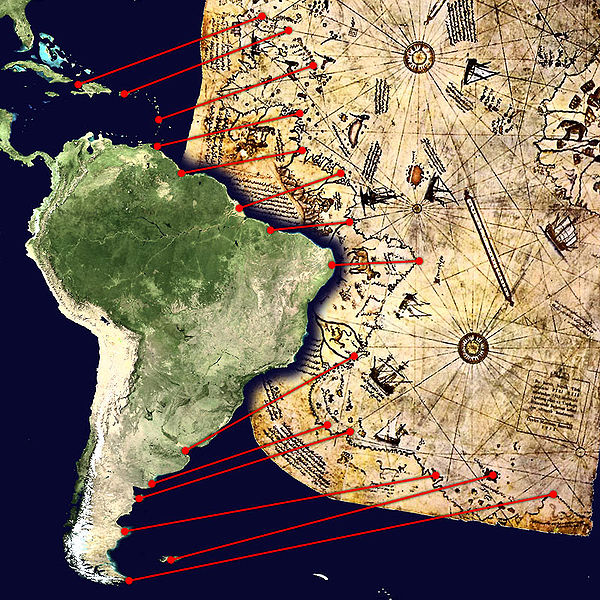
Surviving fragment of the Piri Reis map showing Central and South America shores.
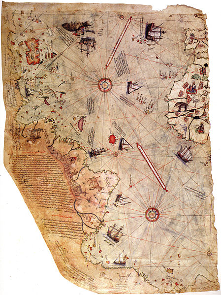
Comparison between a modern projection of South America and Piri Reis's version.
Could this Earth Crust Displacement Hypothesis be the next similar frontier in geology?
en.wikipedia.org...
Scientific research
It is now established that true polar wander has occurred at various times in the past, but at rates of 1° per million years or less.[2][3][18] Analysis of the evidence does not lend credence to Hapgood's hypothesized rapid displacement of layers of the Earth.[19] Although Hapgood drastically overestimated the effects of changing mass distributions across the Earth,[citation needed] calculations show that changing mass distributions both on the surface and in the mantle can cause true polar wander.
(I notice the above extremely brief wiki entry lacks citations refuting his claims [rather those supporting other theories [2][3][18]], and also lacks citations supporting it too)
In a nutshell he proposes that the crust of the Earth can sometimes move conformally, in addition to plate tectonics, around the mantle. This would explain in the past how areas of the Earth like America were covered by up to 2km of ice in the previous Iceages, as back then they had been shifted into a similar position as to that of the modern day Arctic/Antarctica, for periods of possibly tens of thousands of years.
He uses other more circumstantial evidence in support of this theory too, the text is 450 pages long, and extremely in detail research.
Other links I found at the top of Google on ECD that are informative are:
Theory of Crustal Displacement
www.skrause.org...
Theory of Crustal Displacement
www.crystalinks.com...
Hapgoods wiki
en.wikipedia.org...
Again full text here, it's nearly 450 pages long:
Archive.org Main page: Eaths Shifting Crust (1958/00/00)
full text [PDF]
Brief Excerpt:
"We know that there is no absolute knowledge, that there are only theories; but we forget this. The better educated we are, the harder we believe in axioms. I asked Einstein in Berlin once how he, a trained, drilled, teaching scientist of the worst sort, a mathematician, physicist, astronomer, had been able to make his discoveries. 'How did you ever do it/ I exclaimed, and he, understanding and smiling, gave the answer:
" 'By challenging an axiom I' "
Lincoln Steffens, Autobiography (p. 816)
FOREWORD by Albert Einstein
I frequently receive communications from people who wish to consult me concerning their unpublished ideas. It -goes without saying that these ideas are very seldom possessed of scientific validity. The very first communication, however, that I received from Mr. Hapgood electrified me. His idea is original, of great simplicity, and if it continues to prove it- selfof great importance to everything that is related to the history of the earth's surface.
A great many empirical data indicate that at each point on the earth's surface that has been carefully studied, many climatic changes have taken place, apparently quite suddenly. This, according to Hapgood, is explicable if the virtually rigid outer crust of the earth undergoes, from time to time, extensive displacement over the viscous, plastic, possibly fluid inner layers. Such displacements may take place as the consequence of comparatively slight forces exerted on the crust, derived from the earth's momentum of rotation, which in turn will tend to alter the axis of rotation of the earth's crust.[....]
Anyone here read it? Anyone here got opinions on it?
Recent audio discussion of this theory on science friday, in which they do not really menti9on Hapgood but just propose it as a plausible theory (even though it's been around for over 60 years just largely ignored by geologists!)
sciencefriday.com...
I think this is the paper that the segment was discussing from nature, but it is framed much more in terms of conventional geology than Hapgoods theory.
Mechanisms for oscillatory true polar wander
Mechanisms for oscillatory true polar wander
November 2012
Palaeomagnetic studies1, 2, 3, 4, 5 of Palaeoproterozoic to Cretaceous rocks propose a suite of large and relatively rapid (tens of degrees over 10 to 100 million years) excursions of the rotation pole relative to the surface geography, or true polar wander (TPW). We speculate that these sources of stabilization, acting on TPW driven by a time-varying mantle flow field11, 12, 15, 16, 17, 18, provide a mechanism for linking the distinct, oscillatory TPW events of the past few billion years.
Hapgood created his theory documenting three Earth crust displacements in the last 100,000 years. Some researchers believe that they happen every 41,000 years and that the last one happened 11,500 years ago. Hapgood believes that this cataclysmic shift is caused by imbalanced ice at the polar caps. Over time ice builds up at the poles reaching as much as two miles in thickness.
Hapgood concluded that advanced cartographic knowledge appears on the Piri Reis map and the Oronteus Finaeus map, and must be the result of some unknown and advanced ancient civilization that developed astronomy, navigational instruments, plane geometry and trigonometry, long before Greece or any other known civilization.
The Piri Reis map
Charles Hapgood began studying the map in the middle of the 20th century and published the book Maps of the Ancient Sea Kings in 1966.
en.wikipedia.org...
The Piri Reis map is a pre-modern world map compiled in 1513 from military intelligence by the Ottoman admiral and cartographer Piri Reis. The approximately one-third of the map that survives shows the western coasts of Europe and North Africa and the coast of Brazil with reasonable accuracy. Various Atlantic islands including the Azores and Canary Islands are depicted, as is the mythical island of Antillia and possibly Japan. The historical importance of the map lies in its demonstration of the extent of exploration of the New World by approximately 1510, perhaps before others.
Surviving fragment of the Piri Reis map showing Central and South America shores.
Comparison between a modern projection of South America and Piri Reis's version.
edit on 13-12-2012 by ZeuZZ because: (no reason given)
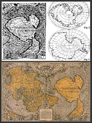
Oronteus Finaeus map
The Oronteus Finaeus map, also spelled Oronteus Fineus map, was incredibly precise. It too shows an ice free Antartica with no ice-cap. It was drawn in the year 1532. There are also maps showing Greenland as two separated islands, as it was confirmed by a polar French expedition which found out that there is an ice cap quite thick joining what it is actually two islands.
en.wikipedia.org...
Here is the Map:
Hapgood made a disclosure which amazingly lead further on this road: he found out a cartographic document copied by an older source carved on a rock column, China, year 1137. It showed the same high level of technology of the other western charts, the same grid method, the same use of spheroid trigonometry. It has so many common points with the western ones that it makes think more than reasonably, that there had to be a common source: could it be a lost civilization, maybe the same one which has been chased by thousands for years so far?
The coastline and island that are shown in Antarctica must have been navigated at some period prior to 4,000 B.C. when these areas were free of ice from the last Ice Age.Piri Reis own commentary indicates that some of his source maps were from the time of Alexander the Great (332 B.C.).
Graham Hancock
According to Graham Hancock's Fingerprints of the Gods, the remains of this civilization lie buried beneath the Antarctic ice cap where it was destroyed and buried by Earth crustal displacement.
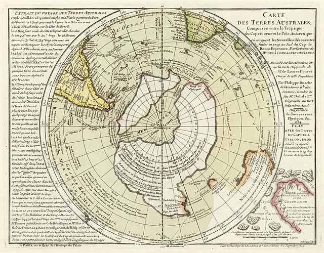
The map below published by Graham Hancock in his book is considered evidence that Antarctic was already known before its effective exploration. The map was created by Philippe Buache, published certainly after 1739 since in its notes there is reference to the journey of Charles Bouvet, who reached the new lands south of Cape of Good Hope the first of January of the same year. Actually the map may seem strange, since the South Pole is placed at the middle of a glacial sea and is surrounded by two wide islands that form a huge austral continent. In this case the similarity with Antarctic is really poor but the fans of mysteries do not discourage because of this and say that this map represent Antarctic before it was covered by glaciers, hundred thousand years ago.
Here is the map:
Back to Charles and the Oronteus Finaeus map
To even the most skeptical, the Oronteus Finaeus map is startling. Although it was printed in a book in 1531 – and was thus not subject to subsequent amendment – it is remarkably similar to today’s maps of Antarctica. Admittedly it is too close to the tip of South America, and it is incorrectly oriented, yet the proportions seem similar, the coastal mountains, found in the 1957 geophysical study are in roughly the right places and so are many bays and rivers. Furthermore, the shape of South America itself seems right, and the close resemblance between a modern, scientifically exact map of the Ross Sea and Finaeus’ unnamed gulf is striking.
What is different, however, is that the Oronteus Finaeus map does not seem to show the great shelves of ice that, today, surround the continent, nor the great glaciers that fringe the coastal regions. Instead there seem to be estuaries and inlets, suggesting great rivers. To Hapgood and his team, that meant that at some time in the past the Ross Sea and its coasts – scene of the November, 1979 air disaster on Mount Erebus – and some of the hinterland of Antarctica were free of ice. It also suggested to Hapgood that since the Antarctic was certainly ice-bound in 1531 – when Oronteus Finaeus made his map – Finaeus must have had access to very ancient maps indeed: maps made when Antarctica was largely free of the mile-thick ice cap that buries it today, and presumably has covered it for millennia.
There is, moreover, the perplexing problem of the Oronteus Finaeus map. Even if Piri Reis “Antarctica” turns out to be South America – drawn horizontally – or even Australia, the Finnaeus “Antarctica” is surely Antarctica and his map was also drawn in the 16th century: 1531. Where did Oronteus Finaeus get his far more detailed and accurate information? Was it the libraries of Alexandria now buried under the sea? And why does Finaeus also show Antarctica without an ice cap? Furthermore, the Hapgood team identified 50 geographical points on the Finaeus map, as re-projected, whose latitudes and longitudes were located quite accurately in latitude and longitude, some of them quite close to the pole. “The mathematical probability against this being accidental,” says Hapgood, “is astronomical”.
The Oronteus Finaeus map, also spelled Oronteus Fineus map, was incredibly precise. It too shows an ice free Antartica with no ice-cap. It was drawn in the year 1532. There are also maps showing Greenland as two separated islands, as it was confirmed by a polar French expedition which found out that there is an ice cap quite thick joining what it is actually two islands.
en.wikipedia.org...
Here is the Map:
Hapgood made a disclosure which amazingly lead further on this road: he found out a cartographic document copied by an older source carved on a rock column, China, year 1137. It showed the same high level of technology of the other western charts, the same grid method, the same use of spheroid trigonometry. It has so many common points with the western ones that it makes think more than reasonably, that there had to be a common source: could it be a lost civilization, maybe the same one which has been chased by thousands for years so far?
The coastline and island that are shown in Antarctica must have been navigated at some period prior to 4,000 B.C. when these areas were free of ice from the last Ice Age.Piri Reis own commentary indicates that some of his source maps were from the time of Alexander the Great (332 B.C.).
Graham Hancock
According to Graham Hancock's Fingerprints of the Gods, the remains of this civilization lie buried beneath the Antarctic ice cap where it was destroyed and buried by Earth crustal displacement.
The map below published by Graham Hancock in his book is considered evidence that Antarctic was already known before its effective exploration. The map was created by Philippe Buache, published certainly after 1739 since in its notes there is reference to the journey of Charles Bouvet, who reached the new lands south of Cape of Good Hope the first of January of the same year. Actually the map may seem strange, since the South Pole is placed at the middle of a glacial sea and is surrounded by two wide islands that form a huge austral continent. In this case the similarity with Antarctic is really poor but the fans of mysteries do not discourage because of this and say that this map represent Antarctic before it was covered by glaciers, hundred thousand years ago.
Here is the map:
Back to Charles and the Oronteus Finaeus map
To even the most skeptical, the Oronteus Finaeus map is startling. Although it was printed in a book in 1531 – and was thus not subject to subsequent amendment – it is remarkably similar to today’s maps of Antarctica. Admittedly it is too close to the tip of South America, and it is incorrectly oriented, yet the proportions seem similar, the coastal mountains, found in the 1957 geophysical study are in roughly the right places and so are many bays and rivers. Furthermore, the shape of South America itself seems right, and the close resemblance between a modern, scientifically exact map of the Ross Sea and Finaeus’ unnamed gulf is striking.
What is different, however, is that the Oronteus Finaeus map does not seem to show the great shelves of ice that, today, surround the continent, nor the great glaciers that fringe the coastal regions. Instead there seem to be estuaries and inlets, suggesting great rivers. To Hapgood and his team, that meant that at some time in the past the Ross Sea and its coasts – scene of the November, 1979 air disaster on Mount Erebus – and some of the hinterland of Antarctica were free of ice. It also suggested to Hapgood that since the Antarctic was certainly ice-bound in 1531 – when Oronteus Finaeus made his map – Finaeus must have had access to very ancient maps indeed: maps made when Antarctica was largely free of the mile-thick ice cap that buries it today, and presumably has covered it for millennia.
There is, moreover, the perplexing problem of the Oronteus Finaeus map. Even if Piri Reis “Antarctica” turns out to be South America – drawn horizontally – or even Australia, the Finnaeus “Antarctica” is surely Antarctica and his map was also drawn in the 16th century: 1531. Where did Oronteus Finaeus get his far more detailed and accurate information? Was it the libraries of Alexandria now buried under the sea? And why does Finaeus also show Antarctica without an ice cap? Furthermore, the Hapgood team identified 50 geographical points on the Finaeus map, as re-projected, whose latitudes and longitudes were located quite accurately in latitude and longitude, some of them quite close to the pole. “The mathematical probability against this being accidental,” says Hapgood, “is astronomical”.
edit on 13-12-2012 by ZeuZZ because: (no reason
given)
So how did this happen to be recorded in not one but at least four maps? Either our “known” history of human beings on this planet is wrong, our
‘history’ of our planet’s development is wrong, there were highly developed civilizations on Earth that we are ignoring because it doesn’t fit
into the established “norm” or the ancient maps that predated these and were used as reference were done by alien cartographers or someone –
drawing our planet from the air.
To put it another away, Hapgood’s work simply cannot be lumped with the lunatic fringe Although unquestionably an amateur theoretician, he did do his homework and had it thoroughly checked by professionals. The U.S. Air Force SAC cartographers, for example, worked with him for two years and fully endorsed his conclusions about Antarctica.
A lot of the above is rewritten and quoted from:
From Maps of the Ancient Sea Kings by Charles Hapgood
Should this be moved to Ancient & Lost Civilizations, or Science, do people think? Or is this the suitable forum?
To be honest, it seems suitable for ALL of them to me
To be honest, it seems suitable for ALL of them to me
edit on 13-12-2012 by ZeuZZ because: (no reason given)
reply to post by ZeuZZ
Marvelous job!
I've read a bit about the Piri Reis map and have always found it fascinating. The map on the stone column found in China in 1137 is something I had not heard about before so kudos to you!
I believe that in Earth's ancient past man had technology far superior than what is opined by most of today's experts, and also that what many call "global warming" is just a repeat of cycles the Earth has experienced many times before. Maps such as the ones you have referenced just lend more credence to some of my ideas.
I think your post is fine in Fragile Earth, but if a mod thinks it belongs somewhere else they will move it. It would fit well in any of the forums you stated. Well done!
There is just so much evidence right in front of all of us that can only lead to the conclusion that there was a previous civilization that was
destroyed by the last ice age.
Similarities in religions, these maps, pyramids dotted around the world, Mayans knowing more about the Universe than we know now: all sorts of evidence just looking straight at you!
Of course if we admit that there was a previous civilization, then we have to admit that an ice age took it out. If we are forced to admit that, then we have to admit that the next one can take us out and then the people would demand that the Governments do something to preserve our butts, and of course there is not much that can be done.
Will the next civilization find the Channel Tunnel and decide it was built to appease the snake god? Or will they find bodies and decide it was a burial tunnel.
The next one is just around the corner.
P
Originally posted by ZeuZZ
Should this be moved to Ancient & Lost Civilizations, or Science, do people think? Or is this the suitable forum?
To be honest, it seems suitable for ALL of them to meedit on 13-12-2012 by ZeuZZ because: (no reason given)
I think you might get more responses if you'd posted this in the Ancient Civilizations forum, but then again, you are talking about the planet and true polar movement too.
Very good thread by the way! I've always found this subject quite interesting.
While I've not ever come across good geological supporting evidence for a global shift (a sudden one that would have cause mega tsunamis, etc), these maps do bring up some good questions.
One thought that I had while reading your thread: ancient star charts.
It would be interesting to see any collaborating evidence using them. We know that ancient peoples studied astronomy, many for cultural, religious reasons more so than science itself. We know that precession of the Earth's axis will have the stars change position, but that's a quantifiable amount that we can see and track even in ancient star charts.
However, global pole shifting other than precession, should show up in those charts (if there are any that exist far back enough, or that were claimed to be copied from, and are accurate enough to actually be usable).
I think it would be interesting research to do, even if nothing quite comes from it.
I have read a great deal about this as well as a good book, fiction, called The Hab Theory, currently out of print I believe, regarding a situation
when the theory becomes known, people try to warn others, and ultimately it happens. With recent news regarding the earthquakes in the middle of our
country (US) on the New Madrid fault and how melting glaciers have caused plates to rise from the decreased weight, who knows what deformations can
happen and what can result?
Couldn't you do this with any sort of shape? I'm sure I could make Australia looks like it lined up there too.
Interesting . Will have to check back to read more thoroughly, so bumping to my ATS subs.
reply to post by ZeuZZ
I have a copy of Hapgood's 'Maps of the Ancient Sea Kings.' I am very familiar with the theory of earth crust displacement and consider the theory to be one that is largely accepted if not formally taught.
Unless my memory is faulty I think that one of the reasons Hapgood investigated the issue was the problem of remanent magnetism, which indicated that at various times in the past the location of the magnetic north pole was other that its position today. Investigations of remanent magnetism of samples from the ocean floor at plate boundaries demonstrates this fact conclusively.
Hapgood did think that excessive ice at the polar ice caps could be a factor but I think that other factors could have been possible, including external events such as gravitational effects caused by occasional close proximity of large 'planetary' bodies.
The subject needs more research.
reply to post by ciscoagent
Yes, he proposed a theory of crustal displacement to explain certain geologica anomalies which were then shown to be much better explained by plate tectonics. Meanwhile Hapgood's theory was falsified on several levels both from evidence availabe at the time and, especially new evidence dscovered in the past 60 years.
The theory is now as dead as the idea continents are stationary relative to one another. Or that Pluto is the largest body in the solar system beyong Neptune.
(and the Piri Re'is map shows the bottom part of S America. Not Antartica - it's obvious if you look for yourself.)
Originally posted by AndyMayhew
reply to post by ciscoagent
Yes, he proposed a theory of crustal displacement to explain certain geologica anomalies which were then shown to be much better explained by plate tectonics. Meanwhile Hapgood's theory was falsified on several levels both from evidence availabe at the time and, especially new evidence dscovered in the past 60 years.
The theory is now as dead as the idea continents are stationary relative to one another. Or that Pluto is the largest body in the solar system beyong Neptune.
(and the Piri Re'is map shows the bottom part of S America. Not Antartica - it's obvious if you look for yourself.)
Evidence of obfuscation noted.
If it's been falsified, then please explain why. Scientifically.
If you do not believe in it then how do you explain the Iceage and similar phenomenon ?
I am in the process of writing a much longer and more coherent OP than this one. Did this one in a slightly rushed manner and it's a bit sloppy and all over the place in parts, but will do nicely to get a productive dialogue going on this subject.
reply to post by ZeuZZ
If the tides of the world are influenced by the moon,and the world has tilted off true north,do you think its possible that the water of the world would want to go towards the moon,causing massive land movement as the tides of the world have changed,there you have droughts,floods and other catastrophes caused by the world moving.I hope this made some sort of sense.I thank you for you time.
If the tides of the world are influenced by the moon,and the world has tilted off true north,do you think its possible that the water of the world would want to go towards the moon,causing massive land movement as the tides of the world have changed,there you have droughts,floods and other catastrophes caused by the world moving.I hope this made some sort of sense.I thank you for you time.
Originally posted by ZeuZZ
If it's been falsified, then please explain why. Scientifically.
Well Hawaii for starters. Added to the fact that West Antarctica was much colder during the last ice age than it is now.
If you do not believe in it then how do you explain the Iceage and similar phenomenon ?
How does Hapgood's theory explain the ice age? How does it explain why everywhere was colder during the ice age and Siberia was a cold dry steppe?
In simple turns, changes in orbital parameters mean cooler N Hemisphere winters, allowing for a gradual build up of ice cap, especially in Baffin and Labrador. Eventually these spread and becie big enough to influence weather first across the N Hemisphere and eventually the whole planet.
If you' like to present, say, your best 3 pieces of geological evidence used by Hapgood in support of his theory, I'll happily show how they have been falsified and/or better explained by more mainstream geological theory.
As a geologist myself I always find this subject interesting in that it fascinates me how a lack of understanding can spurn such wild theories. There
is no possible way that the Earth's crust could suddenly rotate. Not on a time-scale on 1 year, 100 years or even a thousand years; there is simply
no mechanism for it to do so.
I think a lot of this has to do with the media, whenever a story about the Earth's interior (say in the aftermath of an earthquake) comes up, the plates are always represented as floating on the mantle. Let's be clear on this: that is not at all what it is like. The mantle is - for all intents and purposes - as solid as any rock you would pick up in a quarry, it only takes on a plastic quality over geologic time-scales and thus effectively the Earth can be thought of as solid all the way down to the outer core, which even then isn't a liquid with the viscosity of water...
I'd be happy to elaborate further on any points but this is one theory that is not improbable but impossible.
Originally posted by NoExpert
As a geologist myself I always find this subject interesting in that it fascinates me how a lack of understanding can spurn such wild theories. There is no possible way that the Earth's crust could suddenly rotate. Not on a time-scale on 1 year, 100 years or even a thousand years; there is simply no mechanism for it to do so.
I think a lot of this has to do with the media, whenever a story about the Earth's interior (say in the aftermath of an earthquake) comes up, the plates are always represented as floating on the mantle. Let's be clear on this: that is not at all what it is like. The mantle is - for all intents and purposes - as solid as any rock you would pick up in a quarry, it only takes on a plastic quality over geologic time-scales and thus effectively the Earth can be thought of as solid all the way down to the outer core, which even then isn't a liquid with the viscosity of water...
I'd be happy to elaborate further on any points but this is one theory that is not improbable but impossible.
Thanks! Nice to have a geologist on board.
So, as we can discern, the mantle is just about 'as solid as a rock'. I presume that this is due to a gravitational pressure gradient acting on the malleability of a viscous fluid as it is acted on under centripetal gravitational rotation.
So where in this gradient do the fluid hydrodynamic equations come into play over the 'solid as a rock' physics ? The same hydrodynamic equations that give rise to the entire Earths magnetic field in the first place ?
Originally posted by ZeuZZ
Thanks! Nice to have a geologist on board.
So, as we can discern, the mantle is just about 'as solid as a rock'. I presume that this is due to a gravitational pressure gradient acting on the malleability of a viscous fluid as it is acted on under centripetal gravitational rotation.
So where in this gradient do the fluid hydrodynamic equations come into play over the 'solid as a rock' physics ? The same hydrodynamic equations that give rise to the entire Earths magnetic field in the first place ?
Exactly right. Whilst the temperature of the mantle is not hot enough to melt the rocks at about 700km or closer to the surface, beyond this point and at 'normal' conditions it would certainly be sufficient to produce a melt. The fact that this is not the case is due to the enormous pressure and lack of water. Water is thought to be essential for plate tectonics as it lessens the temperature required to produce a melt from the solid mantle and in effect allows for the lubrication of plates. Without water the plates would literally grind to a halt.
I've circled in red the only region where the mantle would not be a solid in this diagram and that's purely due to the down-going slab bringing hydrous minerals into the region which then shift the solidus (the value that demonstrates whether a rock is solid or liquid at a given temperature and pressure) of the rocks toward a melt as can be seen in this diagram if you imagine the white area moving to the left whilst the temperature line remains in the same position.
Though I would say that the rotation of the Earth has very little to do with the physics of plate and mantle motion, they would continue unhindered even if the planet somehow stopped dead.
If I understand you correctly and you're asking for the point at which the 'solid as a rock' physics are overcome; put simply they aren't. The outer core is liquid only due to a change in composition from the mantle and the magnetic field here is generated through convection currents brought on by temperature variations within that liquid. Planetary rotation only serves to 'coil' these currents along a north-south polar axis.
And we've got to remember just how viscous the outer core is, it's about 100 million times thicker than water.
Originally posted by ZeuZZ
...Could this Earth Crust Displacement Hypothesis be the next similar frontier in geology?
Actually - Hapgood's theory hit the big time in the movie "2012"...
A lot of effort has gone into discrediting the theory...and, perhaps, the arguments are legitimate -- Who knows?
Geology is an evolving discipline, like all other sciences - with as many "schools" and explanations as there are Professors with a book to sell.
As another poster noted - I wonder more about the possibility that the polar ice-cap (or a large portion thereof) could have "slipped" into the ocean - causing a massive flood...
reply to post by WanDash
Great information here and I will admit right off the bat I have not read all the links yet but I had to post this tid bit that I just read this morning.....
www.lfpress.com...
Apparently our Equator is not all that stable.
Regards, Iwinder
S&F
This is the same University that discovered the PBA problem with plastics so take this information on the serious side.
edit on 15-12-2012 by Iwinder because: (no reason given)
new topics
-
Suspected Iranian agent working for Pentagon while U.S. coordinated defense of Israel
US Political Madness: 2 minutes ago -
How does my computer know
Education and Media: 2 hours ago -
USO 10 miles west of caladesi island, Clearwater beach Florida
Aliens and UFOs: 7 hours ago
top topics
-
Running Through Idiot Protestors Who Block The Road
Rant: 17 hours ago, 13 flags -
Tesla cutting 14,000 jobs
Global Meltdown: 16 hours ago, 6 flags -
Israel ufo shoot down drones?
Aliens and UFOs: 16 hours ago, 6 flags -
USO 10 miles west of caladesi island, Clearwater beach Florida
Aliens and UFOs: 7 hours ago, 6 flags -
Abortions in first 12 weeks should be legalised in Germany, commission says
Medical Issues & Conspiracies: 15 hours ago, 5 flags -
On this Day in History, April 15, 1865, Abraham Lincoln Passed Away.
General Chit Chat: 16 hours ago, 4 flags -
How does my computer know
Education and Media: 2 hours ago, 0 flags -
Suspected Iranian agent working for Pentagon while U.S. coordinated defense of Israel
US Political Madness: 2 minutes ago, 0 flags
active topics
-
Reason of the Existence
The Gray Area • 18 • : andy06shake -
Suspected Iranian agent working for Pentagon while U.S. coordinated defense of Israel
US Political Madness • 0 • : ADVISOR -
Are the 'Abrahamic Religions' all Really the Worshipping the Same Abrahamic God?
Conspiracies in Religions • 169 • : FlyersFan -
Fossils in Greece Suggest Human Ancestors Evolved in Europe, Not Africa
Origins and Creationism • 48 • : strongfp -
The most astonishing sustained dream world I have ever experienced - MMPORG virtual reality
The Gray Area • 9 • : andy06shake -
Congressional "Hush Fund" and Rape Culture of DC Politicians.
US Political Madness • 29 • : ADVISOR -
End of cash coming to uk soon
Political Issues • 122 • : andy06shake -
Putin Compares Himself to Jesus Promoting Traditional Values Against the Satanic West
Mainstream News • 67 • : andy06shake -
Report March 2024 - Underwater UFOs display capability that ‘jeopardizes US maritime security,’
Aliens and UFOs • 20 • : ARM19688 -
Negotiations and Diplomacy.
History • 10 • : chr0naut