It looks like you're using an Ad Blocker.
Please white-list or disable AboveTopSecret.com in your ad-blocking tool.
Thank you.
Some features of ATS will be disabled while you continue to use an ad-blocker.

T-28 Days and counting!
page: 5share:
reply to post by BrokenAngelWings33
Yes indeed it should, in fact as all the graphs should but time is limited and whilst I have nearly completed the hurricane data back to 2010 I have not sort out a graph for it yet.
Hopefully in the next few days but real life has intervened as you will see from my next post.
Shouldn't this include data from previous years to quantify? (Hurricane data)
Yes indeed it should, in fact as all the graphs should but time is limited and whilst I have nearly completed the hurricane data back to 2010 I have not sort out a graph for it yet.
Hopefully in the next few days but real life has intervened as you will see from my next post.
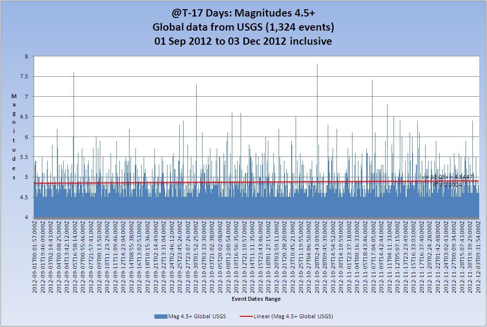
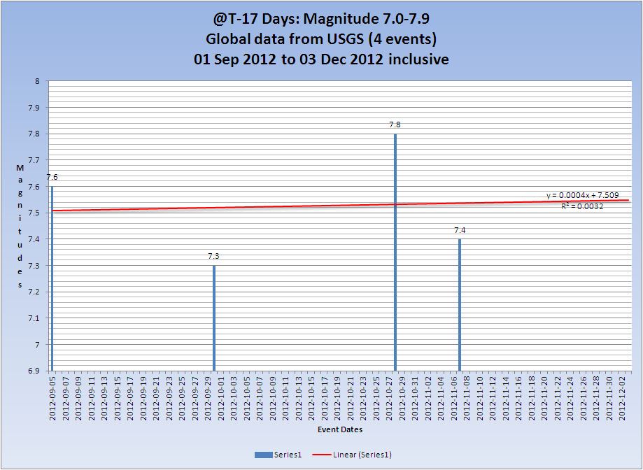
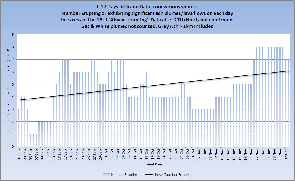
T-17 Days and counting
Earthquakes
Due to serious illness in the family these reports will be minimal for the next week or so. Sorry.
Mag 5 quakes are still well below the average and this often indicates an imminent large earthquake 7+. The trend is still up, but the trend itself continues to drop very slightly.
Listing for the 03 December. 9 x 4.5/4.9, 1 x 5.0/5.9
Prov,Date/Time UTC,Latitude,Longitude,Magnitude,Depth(Km),Location
usgs,2012-12-03 23:58:36, 14.219, -92.317, 5.5, 35.2, Offshore Guatemala
usgs,2012-12-03 23:56:05, 14.958, 42.220, 4.5, 10.0, Nr. W. Coast Of Yemen
usgs,2012-12-03 17:48:28, 43.082, 145.869, 4.7, 57.2, Hokkaido. Japan Region
usgs,2012-12-03 14:29:33, 28.076, 129.455, 4.6, 47.0, Ryukyu Isls. Japan
usgs,2012-12-03 12:53:24, 30.497, 57.205, 4.6, 10.2, Eastern Iran
usgs,2012-12-03 11:55:25, 23.237, 95.926, 4.6, 16.8, Myanmar
usgs,2012-12-03 09:31:54, -28.733, -70.181, 4.9, 81.3, Atacama. Chile
usgs,2012-12-03 04:57:12, 36.270, 140.766, 4.7, 67.1, Nr. E. Coast Of Honshu. Japan
usgs,2012-12-03 03:11:20, -59.006, -26.438, 4.8, 115.7, South Sandwich Isls. Region
usgs,2012-12-03 02:50:10, -47.465, 104.922, 4.6, 10.0, S.East Indian Ridge
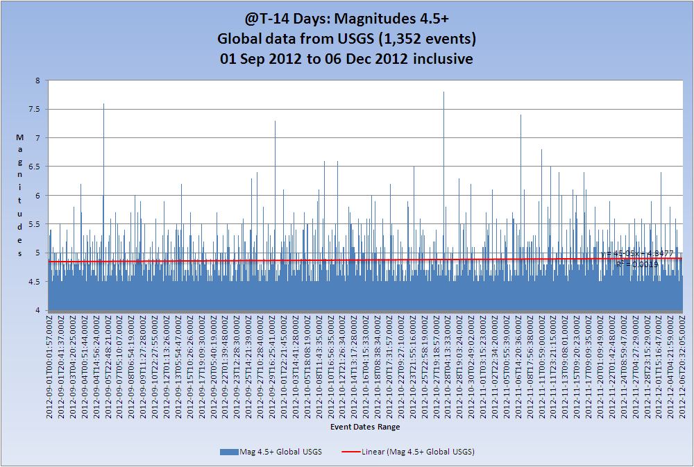
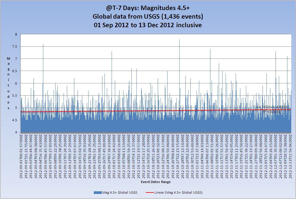
All Magnitudes 4.5+
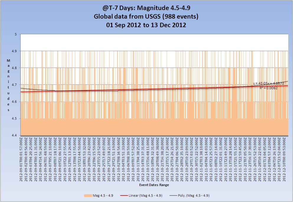
Mag 4.5 to 4.9

Mag 5.0 to 5.9

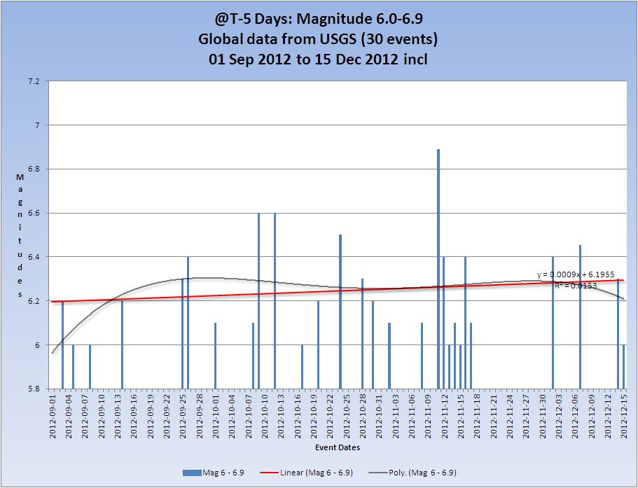
Mag 6.0 to 6.9

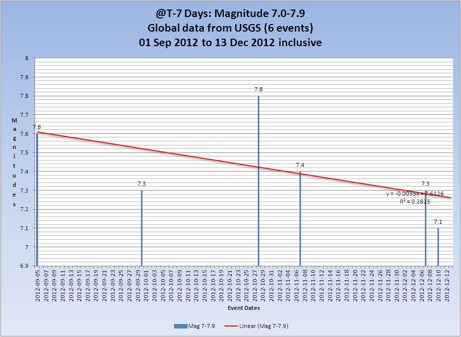
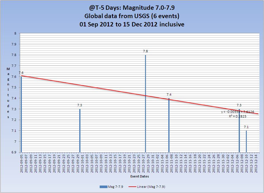
Mag 7.0 to 7.9
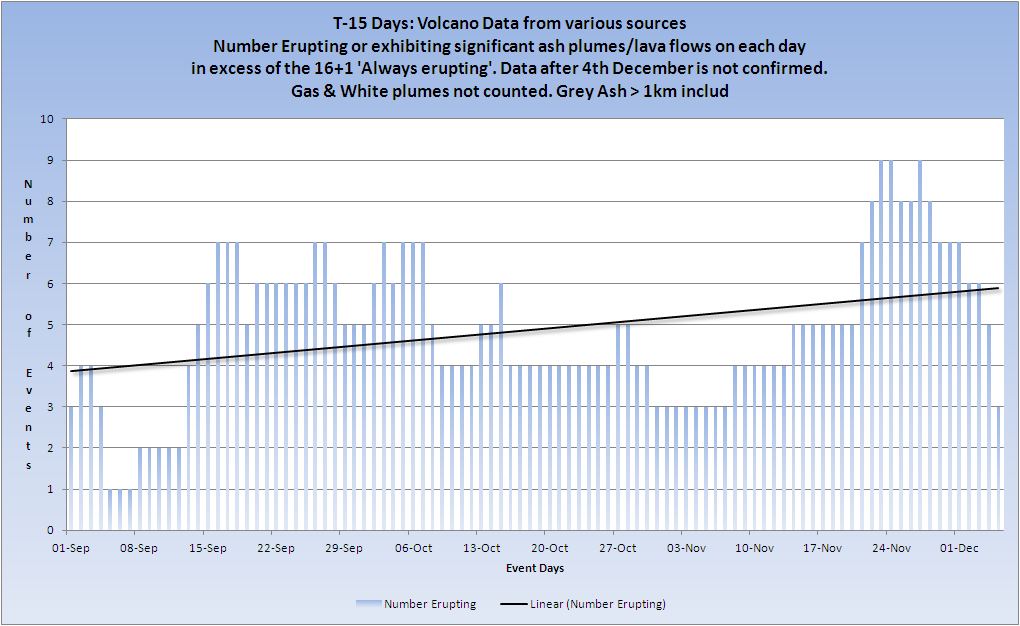
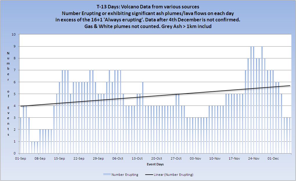
Volcanoes
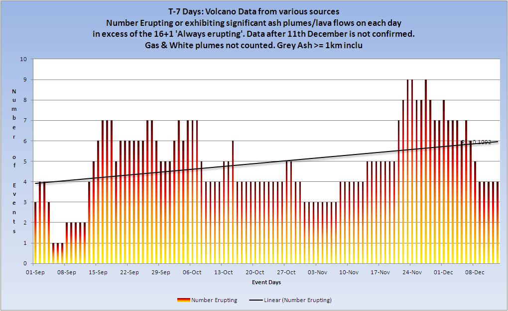
Volcano Chart
Australian VAAC
Commonwealth of Australia, Bureau of Meteorology VAAC
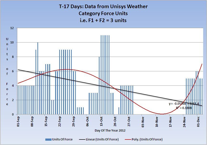
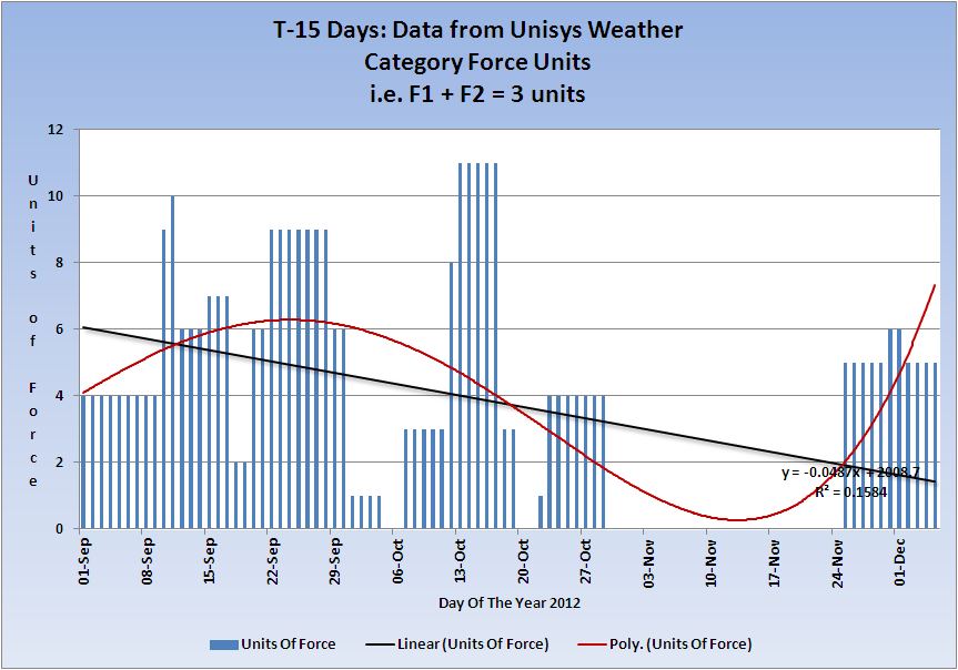
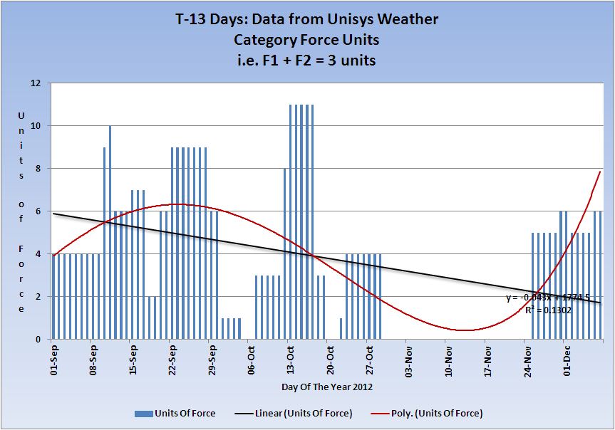
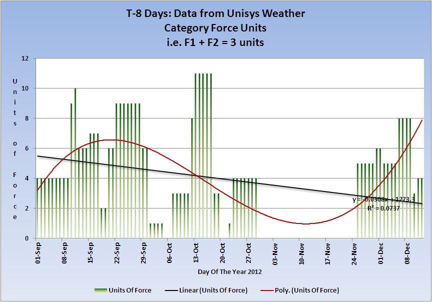
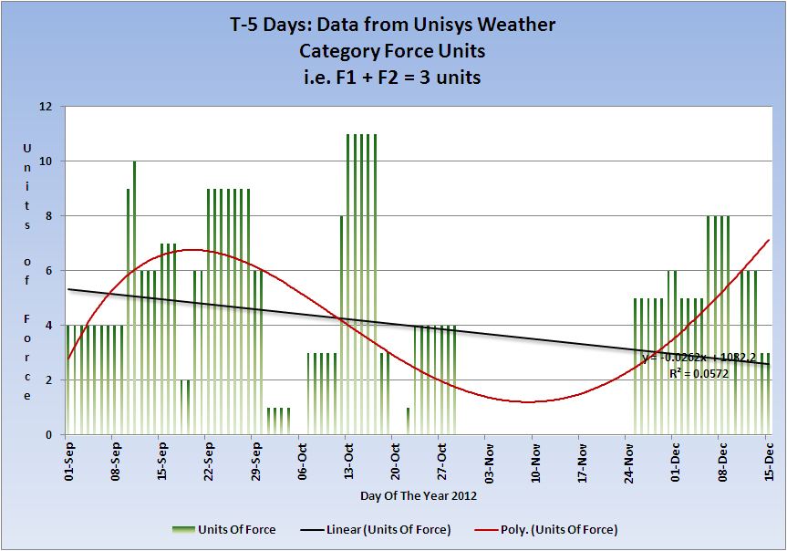
Category 1+ storms
Cat 1+ Storms Chart
BOPHA continues and is raised to Category 5.
Typhoon Bopha Hits the Philippines, Killing at Least 7.
Super Typhoon-5 BOPHA, 25 NOV-04 DEC, 140 kts, 5 - Active (Western Pacific)
That concludes the report of yesterday 03 December 2012 UTC.
edit on 4/12/2012 by PuterMan because: to add more information
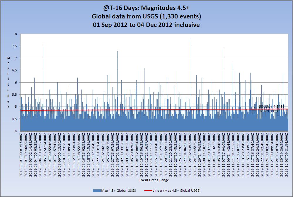
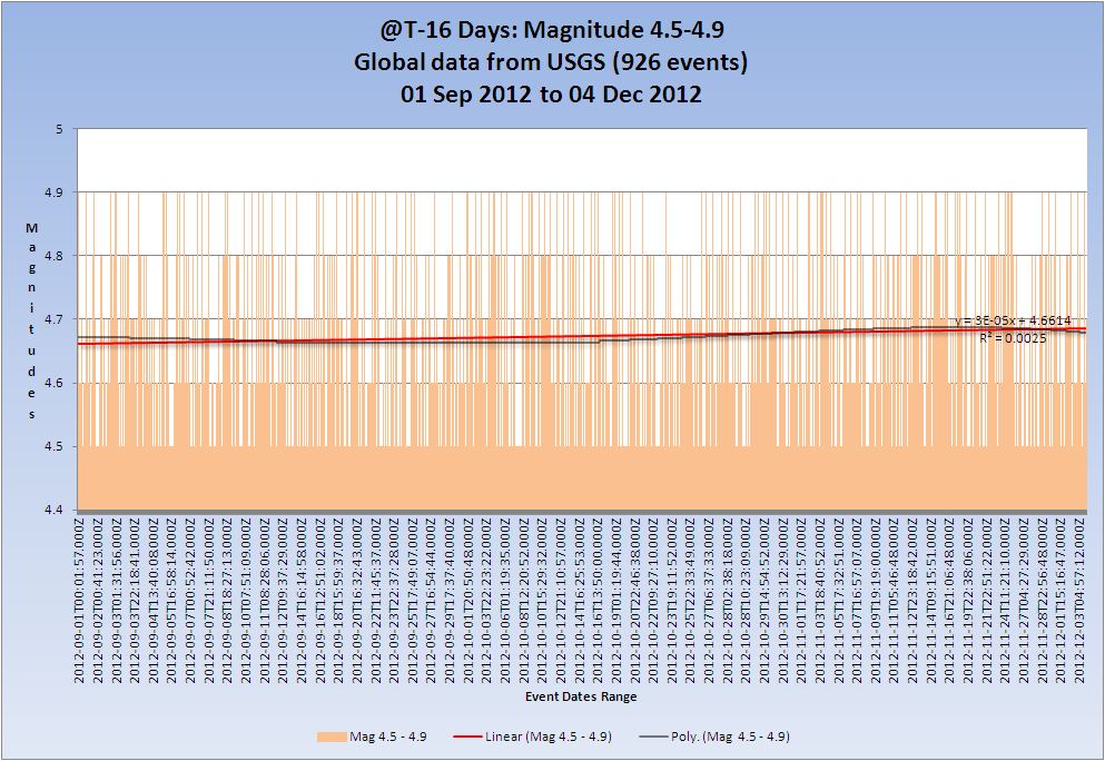
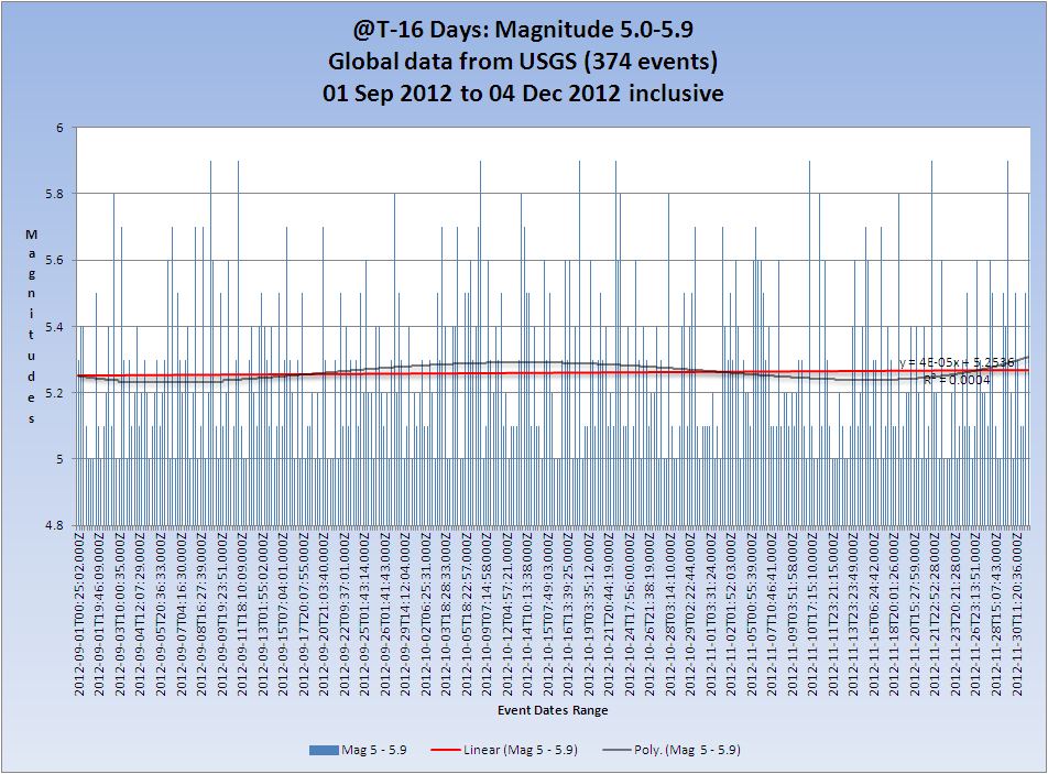
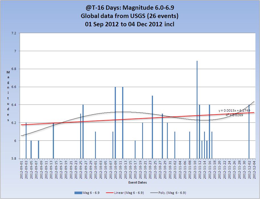
T-16 Days and counting
Earthquakes
Due to serious illness in the family these reports will be minimal for the next week or so. Sorry.
Mag 5 quakes are still WELL below the average and this oftem indicates an iminent large earthquake 7+. The trend is still up, but the trend itself continues to drop very slightly.
Listing for the 04 December. 5 x 4.5/4.9, 1 x 5.0/5.9
Prov,Date/Time UTC,Latitude,Longitude,Magnitude,Depth(Km),Location
usgs,2012-12-04 23:12:25, -34.227, -178.889, 4.7, 73.1, South Of The Kermadec Isls.
usgs,2012-12-04 21:52:06, 41.931, 142.316, 4.6, 56.7, Hokkaido. Japan Region
usgs,2012-12-04 18:59:43, 36.934, 23.089, 4.9, 12.8, Southern Greece
usgs,2012-12-04 09:26:15, -32.771, -71.700, 4.6, 46.3, Offshore Valparaiso. Chile
usgs,2012-12-04 04:21:59, -8.889, -74.399, 4.5, 149.9, Central Peru
usgs,2012-12-04 01:42:48, 61.230, -150.719, 5.8, 53.2, Southern Alaska
All Magnitudes 4.5+
Mag 4.5 to 4.9
Mag 5.0 to 5.9
Mag 6.0 to 6.9
Mag 7.0 to 7.9

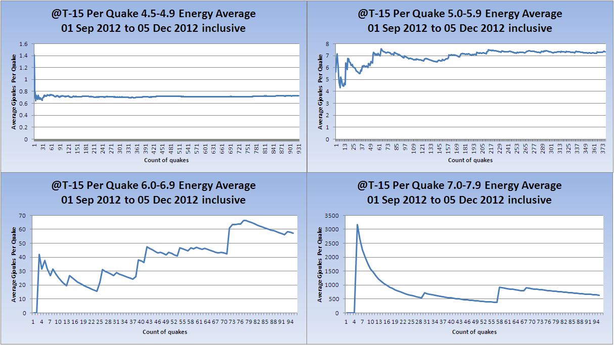
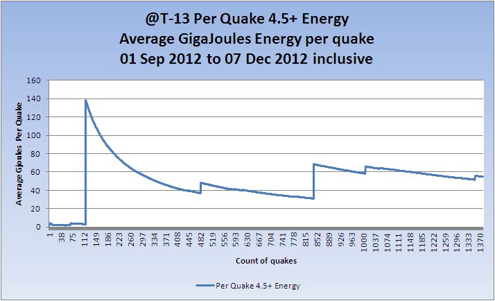
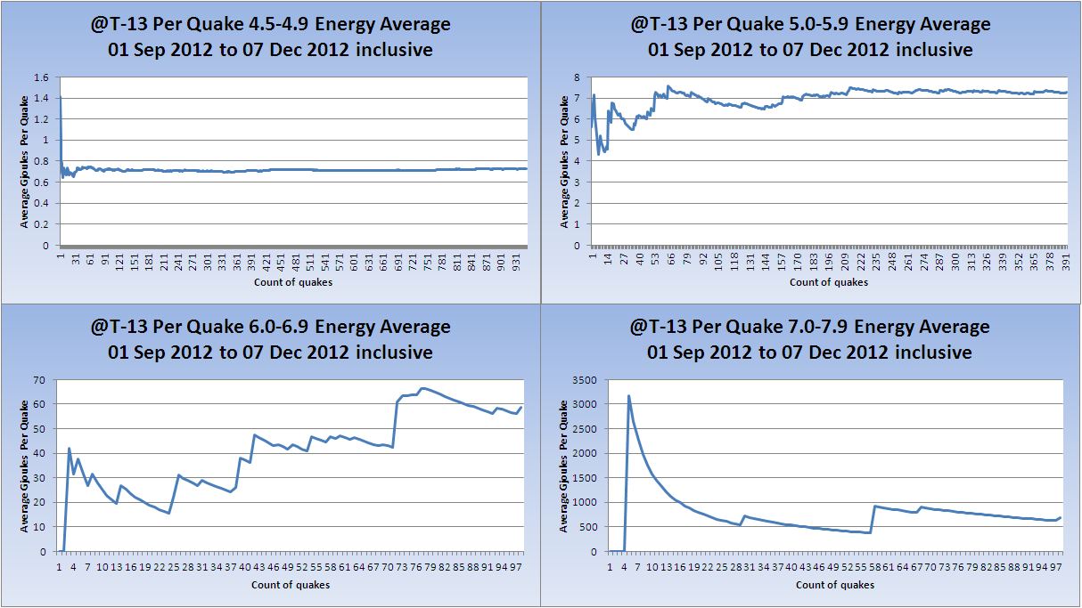
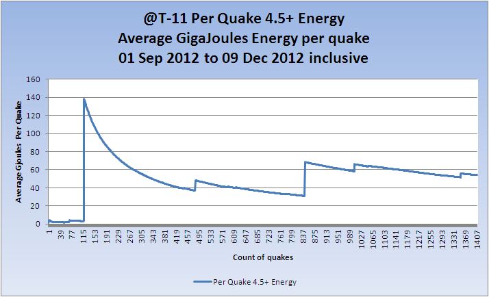
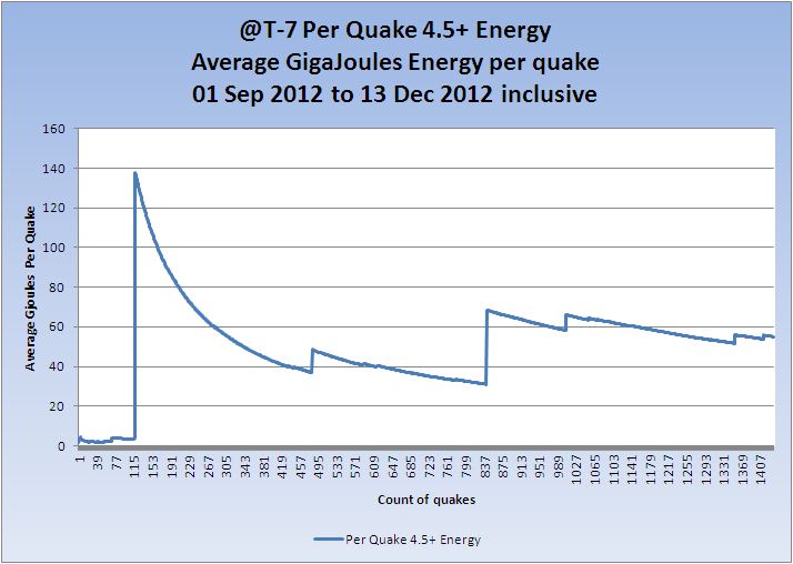
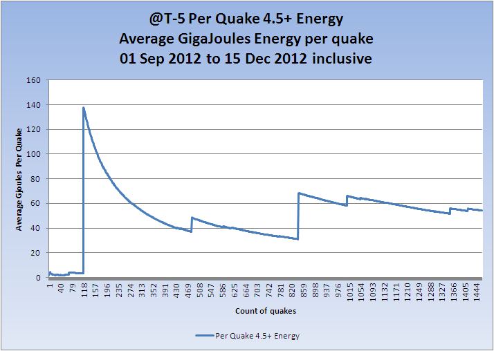
New charts for today - Average energy per quake Mag 4.5+
(These merely indicate the average per quake which is only useful as a 'trend' of overall energy)
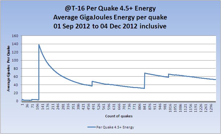
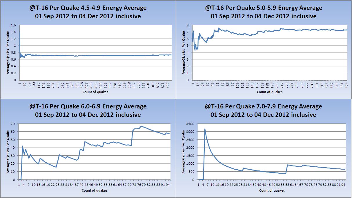
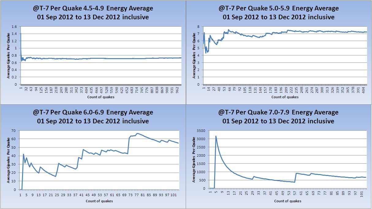
And each Magnitude band
Volcanoes
Volcano Chart

Australian VAAC
Commonwealth of Australia, Bureau of Meteorology VAAC
Category 1+ storms
Cat 1+ Storms Chart
BOPHA continues (unable to connect but it won't have dissipated yet so I am assuming continuation) and is Category 5.
Super Typhoon-5 BOPHA, 25 NOV-04 DEC, 140 kts, 5 - Active (Western Pacific)
That concludes the report of yesterday 04 December 2012 UTC.
T-15 Days and counting
Earthquakes
An increase in Mag 5 quakes but they are still WELL below the average. The trend is still up, but the trend itself continues to drop very slightly - even with the slight increase in numbers.
Listing for the 05 December. 6 x 4.5/4.9, 3 x 5.0/5.9
Prov,Date/Time UTC,Latitude,Longitude,Magnitude,Depth(Km),Location
usgs,2012-12-05 23:41:56, -31.035, -177.571, 5.1, 29.9, Kermadec Isls. Region
usgs,2012-12-05 23:08:37, -20.709, -178.932, 5.1, 617.7, Fiji Region
usgs,2012-12-05 17:08:12, 33.490, 59.554, 5.6, 5.6, Eastern Iran
usgs,2012-12-05 16:25:31, -28.628, -70.037, 4.6, 71.5, Atacama. Chile
usgs,2012-12-05 14:35:00, 64.886, -133.990, 4.5, 5.0, Southern Yukon Territory. Canada
usgs,2012-12-05 13:48:46, -14.969, -173.237, 4.9, 35.8, Samoa Isls. Region
usgs,2012-12-05 11:22:02, -15.133, -173.671, 4.7, 9.8, Tonga
usgs,2012-12-05 01:10:47, 44.331, 147.733, 4.7, 89.2, Kuril Isls.
usgs,2012-12-05 00:33:35, 60.510, -177.831, 4.5, 14.5, Bering Sea
All Magnitudes 4.5+
Mag 4.5 to 4.9

Mag 5.0 to 5.9

Mag 6.0 to 6.9

Mag 7.0 to 7.9

Average energy per quake Mag 4.5+
(These merely indicate the average per quake which is only useful as a 'trend' of overall energy, which if the end is nigh should ramp up on would presume )

And each Magnitude band
Volcanoes
Volcano Chart
KVERT reported that an eruption from Tolbachik that began on 27 November continued through 30 November. Lava effused from two fissures along the W side of Tolbachinsky Dol, a lava plateau on the SW side of the volcano, and ash plumes rose less than 500 m on 28 November. A large thermal anomaly was detected on the N part of Tolbachinsky Dol. On 29 November the Aviation Color Code was raised to Red. Ash plumes rose less than 500 m and drifted 300 km ESE. Later that day seismicity decreased and the Aviation Color Code was lowered to Orange. During 29 November-1 December Strombolian activity and lava effusion from two fissures continued. A large thermal anomaly continued to be detected in satellite imagery, and ashfall was reported in Kozyrevsk (40 km NW). According to a news article on 30 November, the lava flows destroyed two scientific base camps 10 km away. On 1 December gas-and-steam plumes with small amounts of ash rose over 400 m. Based on information from UHPP (Yelizovo Airport), the Tokyo VAAC reported that ash plumes rose to altitudes of 4-6.1 km (13,000-20,000 ft) a.s.l. and drifted N and NW during 29-30 November and 3 December.
Source: Smithsonian
Darwin VAAC reported that during 28 November-4 December ash plumes from Paluweh rose to altitudes of 1.5-2.4 km (5,000-8,000 ft) a.s.l. and drifted 35-65 km NW and W. The Volcano Discovery team observed Paluweh during 30 November-2 December. They reported that a lava dome seemed to be visibly growing from all sides, with almost constant incandescent rockfalls in multiple areas. The dome was about 150 m high, the highest point on the island, and the basal diameter was 200-250 m.
Australian VAAC
Commonwealth of Australia, Bureau of Meteorology VAAC
Category 1+ storms
Cat 1+ Storms Chart
BOPHA continues.
Super Typhoon-5 BOPHA, 25 NOV-06 DEC, 140 kts, 5 - Active (Western Pacific)
A powerful typhoon that washed away emergency shelters, a military camp and possibly entire families in the southern Philippines has killed almost 350 people with nearly 400 missing, authorities said on Thursday.
More bodies were retrieved from hardest-hit Compostela Valley and Davao Oriental provinces and six others affected by Tuesday's storm, the Office of Civil Defence said.
At least 200 of the victims died in Compostela Valley alone, including 78 villagers and soldiers who perished in a flash flood that swamped two emergency shelters and a military camp.
"Entire families may have been washed away," said the interior secretary, Mar Roxas, who visited New Bataan on Wednesday. The farming town of 45,000 people was a muddy wasteland of collapsed houses and coconut and banana trees felled by ferocious winds.
Source: The Guardian
Further reading: 477 dead, many homeless in Philippines typhoon
That concludes the report of 15th
edit on 6/12/2012 by PuterMan because: to fix a tag
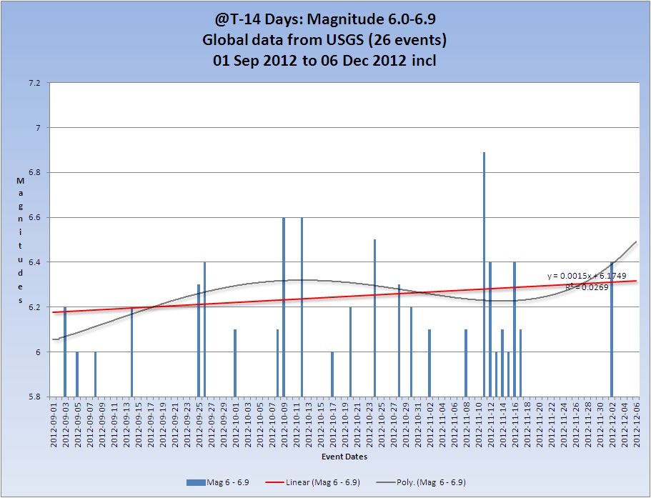
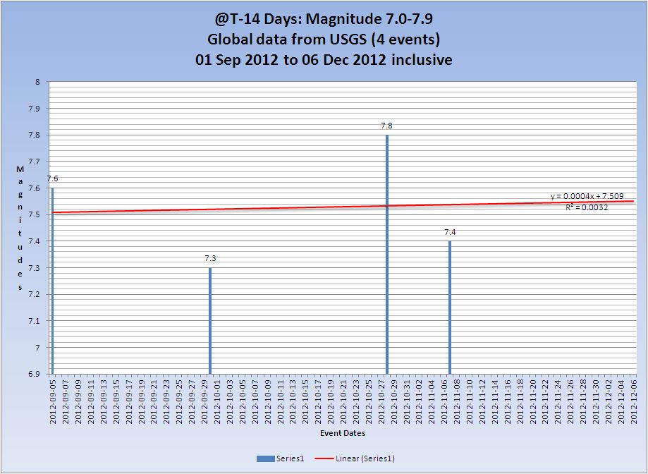
T-14 Days and counting
Earthquakes
Whilst this report looks back at the previous day there has of course been a Mag 7.3 and a Mag 6.2 off the coast of Japan ~260km from Fukushima. There will be reported on tomorrow as usual but they are significant enough to mention today.
Prov,Date/Time UTC,Latitude,Longitude,Magnitude,Depth(Km),Location
usgs,2012-12-07 09:01:53, 37.740, 143.542, 4.7, 35.3, Off E. Coast Of Honshu. Japan
usgs,2012-12-07 08:48:15, 37.848, 143.581, 5.5, 34.8, Off E. Coast Of Honshu. Japan
usgs,2012-12-07 08:31:14, 37.938, 143.762, 6.2, 29.2, Off E. Coast Of Honshu. Japan
usgs,2012-12-07 08:18:24, 37.888, 144.090, 7.3, 36.1, Off E. Coast Of Honshu. Japan
You will find topics for these here and here.
An increase in Mag 4 and Mag 5 quakes but they are still below the average. The trend is still up, but the trend itself continues to drop very slightly - even with the slight increase in numbers.
Listing for the 06 December. 9 x 4.5/4.9, 5 x 5.0/5.9
Prov,Date/Time UTC,Latitude,Longitude,Magnitude,Depth(Km),Location
usgs,2012-12-06 20:42:15, -22.008, -68.410, 4.6, 106.6, Antofagasta. Chile
usgs,2012-12-06 20:32:05, 35.561, 140.082, 4.8, 66.9, Nr. E. Coast Of Honshu. Japan
usgs,2012-12-06 18:58:55, -17.948, -69.470, 5.0, 122.9, Tarapaca. Chile
usgs,2012-12-06 17:48:15, 36.940, 23.110, 4.9, 12.8, Southern Greece
usgs,2012-12-06 16:52:24, -56.087, -27.399, 5.0, 103.6, South Sandwich Isls. Region
usgs,2012-12-06 15:46:50, -54.038, -1.963, 4.9, 18.7, Bouvet Island Region
usgs,2012-12-06 10:26:19, 10.945, 126.686, 4.6, 35.1, Philippine Isls. Region
usgs,2012-12-06 10:17:35, 36.460, 140.718, 4.5, 67.5, Nr. E. Coast Of Honshu. Japan
usgs,2012-12-06 06:11:51, -5.014, 143.083, 4.7, 142.8, New Guinea. P.N.G
usgs,2012-12-06 04:09:07, -8.387, 120.480, 4.5, 43.6, Flores Region. Ind.
usgs,2012-12-06 02:24:25, 2.462, 90.434, 5.1, 11.8, Off W. Coast Of Northern Sumatra
usgs,2012-12-06 01:15:15, -2.879, 129.295, 4.7, 41.7, Seram. Ind.
usgs,2012-12-06 00:43:24, 11.002, 126.617, 5.4, 28.3, Philippine Isls. Region
All Magnitudes 4.5+
Mag 4.5 to 4.9

Mag 5.0 to 5.9

Mag 6.0 to 6.9
Mag 7.0 to 7.9
Average energy per quake Mag 4.5+
(These merely indicate the average per quake which is only useful as a 'trend' of overall energy, which if the end is nigh should ramp up on would presume )

And each Magnitude band

Volcanoes
Volcano Chart

Australian VAAC
Commonwealth of Australia, Bureau of Meteorology VAAC
Category 1+ storms
Cat 1+ Storms Chart
BOPHA continues.
Super Typhoon-5 BOPHA, 25 NOV-07 DEC, 140 kts, 5 - Active (Western Pacific)
See above for links to news reports.
That concludes the report of yesterday 06 December 2012 UTC.
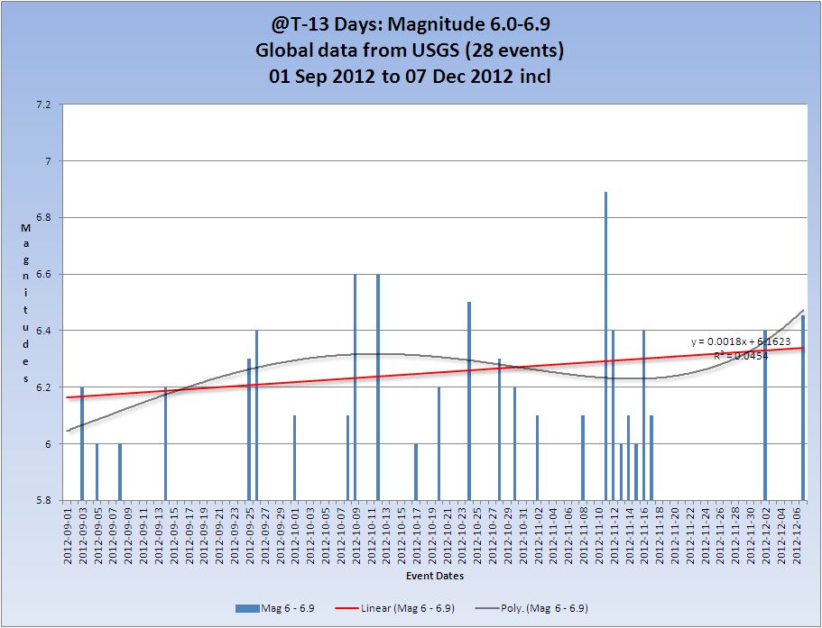
T-13 Days and counting
Earthquakes
An obvious increase in Mag 4 and Mag 5 quakes which are almost all attributable to the Magnitude 7 in Japan. The overall trend is still up, and the events of the 7th cause a very slight increase in the overall trend from R2=0.0019 to 0.0038
Listing for the 07 December. 14 x 4.5/4.9, 11 x 5.0/5.9, 2 x 6.0/6.9, 1 x 7.0/7.9
Prov,Date/Time UTC,Latitude,Longitude,Magnitude,Depth(Km),Location
usgs,2012-12-07 23:52:04, 12.684, -87.868, 4.5, 69.6, Nr. Coast Of Nicaragua
usgs,2012-12-07 23:00:02, 37.732, 143.863, 5.6, 34.2, Off E. Coast Of Honshu. Japan
usgs,2012-12-07 21:36:37, 37.727, 143.568, 4.8, 27.6, Off E. Coast Of Honshu. Japan
usgs,2012-12-07 21:20:52, 37.437, 143.900, 4.7, 40.8, Off E. Coast Of Honshu. Japan
usgs,2012-12-07 21:01:12, 37.446, 143.653, 4.9, 21.7, Off E. Coast Of Honshu. Japan
usgs,2012-12-07 20:30:39, 37.795, 143.603, 4.9, 25.5, Off E. Coast Of Honshu. Japan
usgs,2012-12-07 19:50:21, -7.632, 146.962, 5.6, 118.9, Eastern New Guinea Region. P.N.G
usgs,2012-12-07 19:25:00, 40.880, 142.817, 4.9, 38.5, Nr. E. Coast Of Honshu. Japan
usgs,2012-12-07 18:19:07, -38.320, 176.085, 6.3, 166.8, N. Isl Of Nz
usgs,2012-12-07 16:18:42, 37.707, 143.877, 5.0, 32.6, Off E. Coast Of Honshu. Japan
usgs,2012-12-07 16:11:56, 37.809, 143.740, 4.7, 34.9, Off E. Coast Of Honshu. Japan
usgs,2012-12-07 16:01:54, 37.723, 143.868, 5.1, 30.7, Off E. Coast Of Honshu. Japan
usgs,2012-12-07 15:15:31, 37.800, 143.850, 5.0, 35.8, Off E. Coast Of Honshu. Japan
usgs,2012-12-07 14:32:17, 37.762, 143.637, 4.7, 35.0, Off E. Coast Of Honshu. Japan
usgs,2012-12-07 14:08:43, 38.745, 88.101, 5.3, 16.1, Southern Xinjiang. China
usgs,2012-12-07 12:58:07, 37.877, 143.662, 5.0, 34.9, Off E. Coast Of Honshu. Japan
usgs,2012-12-07 12:48:51, 37.534, 143.715, 4.8, 35.1, Off E. Coast Of Honshu. Japan
usgs,2012-12-07 12:33:37, 37.555, 143.650, 4.7, 34.9, Off E. Coast Of Honshu. Japan
usgs,2012-12-07 12:05:27, 37.852, 143.735, 5.0, 35.0, Off E. Coast Of Honshu. Japan
usgs,2012-12-07 09:56:27, 37.571, 143.774, 4.6, 35.0, Off E. Coast Of Honshu. Japan
usgs,2012-12-07 09:23:04, 37.822, 144.175, 4.8, 35.1, Off E. Coast Of Honshu. Japan
usgs,2012-12-07 09:13:23, 37.721, 143.746, 4.7, 35.1, Off E. Coast Of Honshu. Japan
usgs,2012-12-07 09:01:53, 37.740, 143.542, 4.7, 35.3, Off E. Coast Of Honshu. Japan
usgs,2012-12-07 08:48:15, 37.848, 143.581, 5.5, 34.8, Off E. Coast Of Honshu. Japan
usgs,2012-12-07 08:31:14, 37.938, 143.762, 6.2, 29.2, Off E. Coast Of Honshu. Japan
usgs,2012-12-07 08:18:24, 37.888, 144.090, 7.3, 36.1, Off E. Coast Of Honshu. Japan
usgs,2012-12-07 02:25:46, -5.300, 151.426, 5.1, 94.2, New Britain Region. P.N.G
usgs,2012-12-07 01:35:09, -54.093, -1.927, 5.1, 17.4, Bouvet Island Region
All Magnitudes 4.5+
Mag 4.5 to 4.9

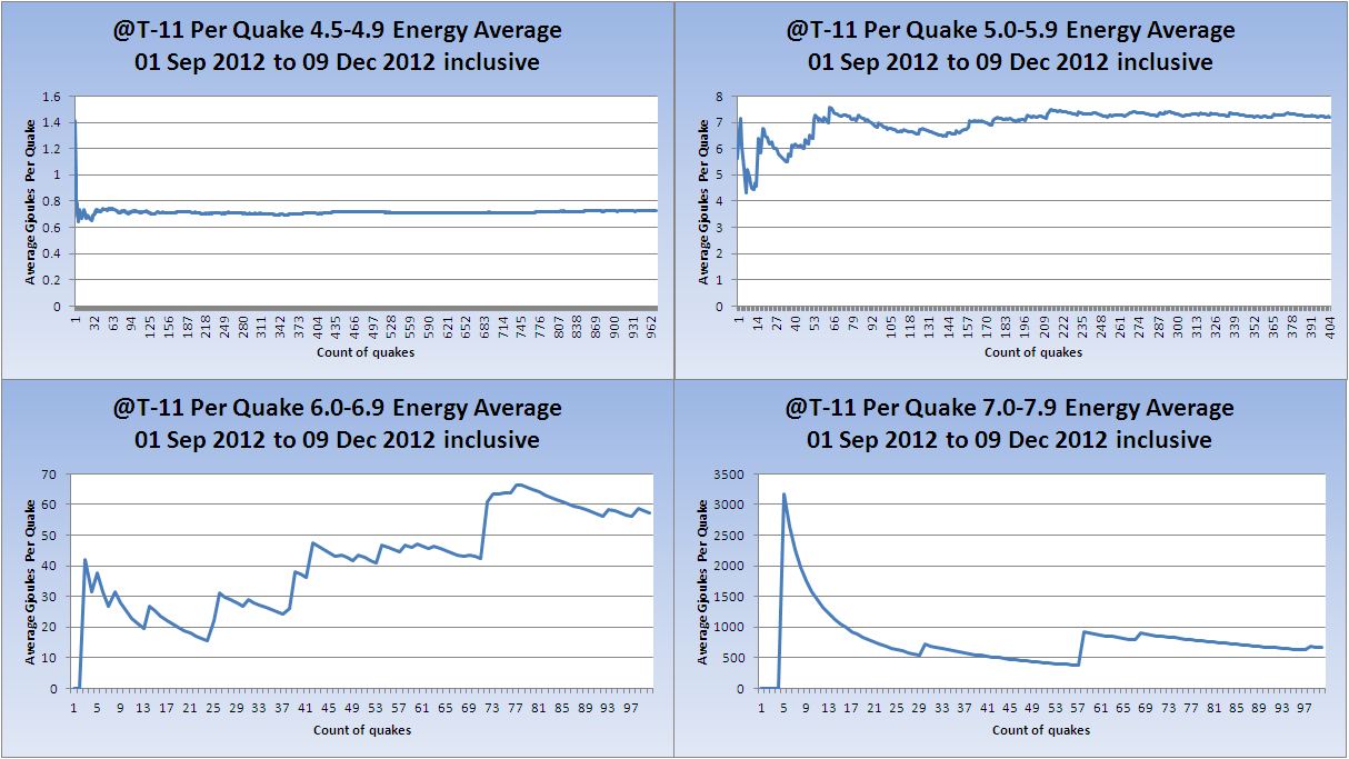
Strangely the M5 magnitudes trend went down again today very slightly indicating lesser magnitudes overall.
Mag 5.0 to 5.9

The two Mag 6 earthquakes are summed as the M6 quakes are shown as a daily figure. The magnitude is converted to ~energy, the products summed and then converted back to a ~magnitude.
125.8925412 GJ
+177.827941 GJ
=303.7204822 GJ
=6.455 Mw
Mag 6.0 to 6.9
The trend of the M7 quakes was completely reversed by this one. Remember that this is the trend of the magnitudes not the trend of the number of quakes.
Mag 7.0 to 7.9

Average energy per quake Mag 4.5+
(These merely indicate the average per quake which is only useful as a 'trend' of overall energy, which if the end is nigh should ramp up on would presume )
If this chart does not look right to you because of the Mag 7 be aware that as the time period covered extends the chart will be less and less affected by big events for lesser magnitude than the largest if that makes sense. The top quake in the list is M7.8 so this quakes at M7.3 is 5.62 times less energy that that. This is why these average of energy charts are not particularly useful but they would show a up-tick in magnitudes straight away. You can see this on the M4 chart in the block of 4 which is showing a slight but steady increase in the energy output of M4.5-4.9 quakes.
Average before the M7 was 55.76106553 GJ/Quake and after was 55.81278491 GJ/Quake
And each Magnitude band
Volcanoes
No known change in volcanic around the world today. Tolbachik is still doing it's thing.
Volcano Chart
Australian VAAC
Commonwealth of Australia, Bureau of Meteorology VAAC
Continued in next post due to very small post limitations..............
Category 1+ storms
Cat 1+ Storms Chart
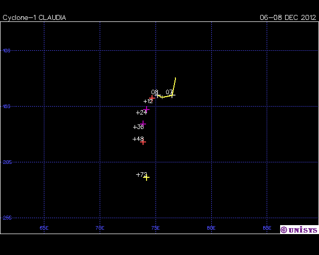
BOPHA continues but the winds have dropped to Cat 3. Claudia in the Southern Indian OCean (Cat 1) is listed to day.
Super Typhoon-5 BOPHA (25 NOV-08 DEC)
Storm - Max Winds: 140 Category: 5
Current - Max Winds: 100 Category: 3
WARNING POSITION:
080600Z --- NEAR 17.3N 117.9E
MOVEMENT PAST SIX HOURS - 065 DEGREES AT 09 KTS
POSITION ACCURATE TO WITHIN 060 NM
POSITION BASED ON CENTER LOCATED BY SATELLITE
PRESENT WIND DISTRIBUTION:
MAX SUSTAINED WINDS - 100 KT, GUSTS 125 KT
WIND RADII VALID OVER OPEN WATER ONLY
RADIUS OF 064 KT WINDS - 035 NM NORTHEAST QUADRANT
040 NM SOUTHEAST QUADRANT
040 NM SOUTHWEST QUADRANT
035 NM NORTHWEST QUADRANT
RADIUS OF 050 KT WINDS - 060 NM NORTHEAST QUADRANT
065 NM SOUTHEAST QUADRANT
065 NM SOUTHWEST QUADRANT
060 NM NORTHWEST QUADRANT
RADIUS OF 034 KT WINDS - 100 NM NORTHEAST QUADRA
Super Typhoon-5 BOPHA, 25 NOV-08 DEC, 140 kts, 5 - Active (Western Pacific)

Scroll down that page for the report above.
New cyclone today added to the listing which was not there yesterday but it appears was active.
17 Cyclone-1 CLAUDIA 06-08 DEC 75 1 Active
Southern Indian Ocean
Claudia is mid ocean and poses no threat to land masses.
That concludes the report of yesterday 07 December 2012 UTC.
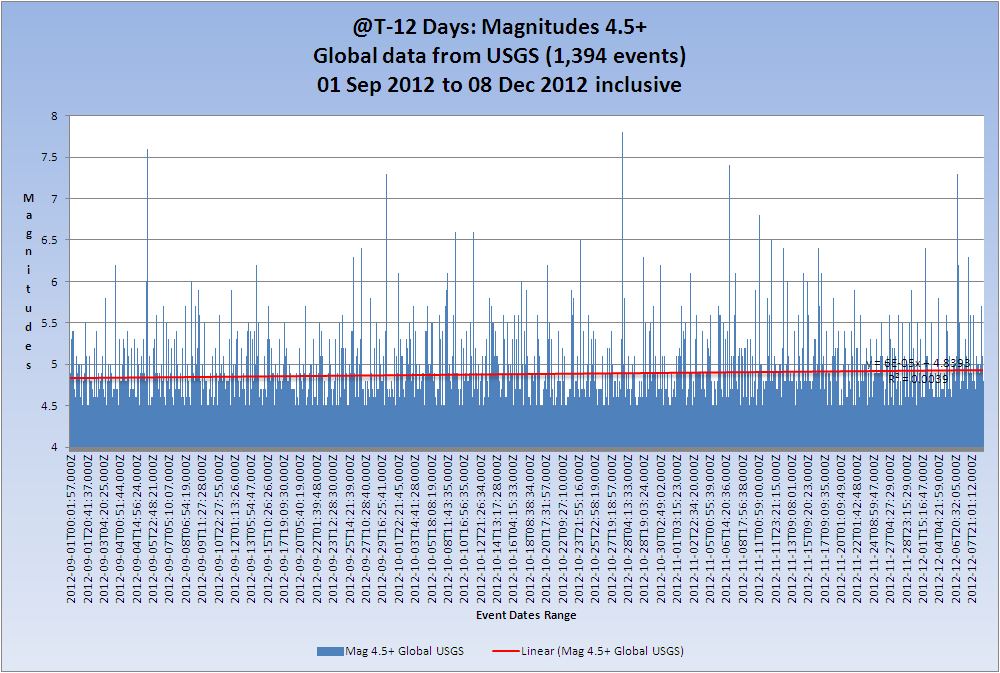
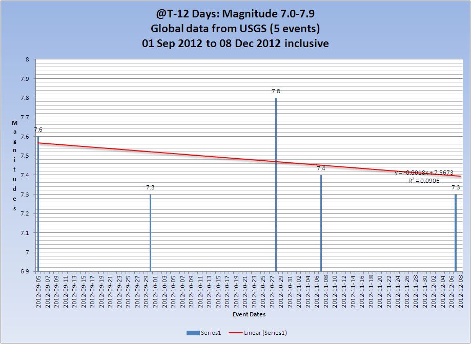
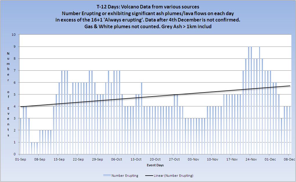
T-12 Days and counting
Earthquakes
The overall trend is still up, and the events of the 8th caused a very slight increase in the overall trend from R2=0.0038 to 0.0039
Listing for the 08 December. 8 x 4.5/4.9, 6 x 5.0/5.9
Prov,Date/Time UTC,Latitude,Longitude,Magnitude,Depth(Km),Location
usgs,2012-12-08 21:46:08, -14.777, 167.219, 4.8, 134.9, Vanuatu
usgs,2012-12-08 20:47:24, -5.172, 102.270, 4.7, 28.9, Southern Sumatra. Ind.
usgs,2012-12-08 19:00:11, -7.192, 144.001, 5.1, 32.8, Nr. S. Coast Of New Guinea. P.N.G
usgs,2012-12-08 16:35:17, -7.210, 143.929, 5.7, 10.7, Nr. S. Coast Of New Guinea. P.N.G
usgs,2012-12-08 14:26:55, 25.753, 122.335, 5.0, 289.1, Taiwan Region
usgs,2012-12-08 13:53:37, 37.768, 143.955, 4.7, 34.7, Off E. Coast Of Honshu. Japan
usgs,2012-12-08 12:50:10, 37.622, 143.568, 4.9, 35.0, Off E. Coast Of Honshu. Japan
usgs,2012-12-08 10:27:31, -7.144, 144.048, 5.0, 33.6, Nr. S. Coast Of New Guinea. P.N.G
usgs,2012-12-08 10:09:41, 38.123, 74.160, 4.7, 157.6, Tajikistan
usgs,2012-12-08 08:11:56, 2.570, 128.367, 5.0, 153.9, Halmahera. Ind.
usgs,2012-12-08 07:18:13, 37.833, 143.883, 4.7, 35.2, Off E. Coast Of Honshu. Japan
usgs,2012-12-08 06:16:55, -7.247, 143.930, 5.1, 21.7, Nr. S. Coast Of New Guinea. P.N.G
usgs,2012-12-08 02:12:52, 37.604, 143.792, 4.7, 30.5, Off E. Coast Of Honshu. Japan
usgs,2012-12-08 00:08:17, 37.921, 143.841, 4.8, 10.7, Off E. Coast Of Honshu. Japan
All Magnitudes 4.5+
Mag 4.5 to 4.9
(The trend of overall magnitude is still increasing slightly)

Strangely the M5 magnitudes trend went down again today very slightly indicating lesser magnitudes overall.
Mag 5.0 to 5.9

Mag 6.0 to 6.9

Mag 7.0 to 7.9
Average energy per quake Mag 4.5+
(These merely indicate the average per quake which is only useful as a 'trend' of overall energy, which if the end is nigh should ramp up on would presume )

And each Magnitude band

Volcanoes
Yesterday and Thursday should have shown Lokon erupting but I had no alert about it until today. I have assumed that it continues today. Tolbachik is still doing it's thing.
Volcano Chart
Australian VAAC
Commonwealth of Australia, Bureau of Meteorology VAAC
Category 1+ storms
Cat 1+ Storms Chart

BOPHA continues but has nearly blown itself out now. Claudia in the Southern Indian OCean (upgraded to Cat 3) is listed to day.
Super Typhoon-5 BOPHA (25 NOV-08 DEC)
Storm - Max Winds: 140 Category: 5
Current - Max Winds: 45 Category: TS
WARNING POSITION:
081800Z --- NEAR 18.1N 119.0E
MOVEMENT PAST SIX HOURS - 035 DEGREES AT 05 KTS
POSITION ACCURATE TO WITHIN 060 NM
POSITION BASED ON CENTER LOCATED BY SATELLITE
PRESENT WIND DISTRIBUTION:
MAX SUSTAINED WINDS - 045 KT, GUSTS 055 KT
WIND RADII VALID OVER OPEN WATER ONLY
DISSIPATING AS A SIGNIFICANT TROPICAL CYCLONE OVER WATER
RADIUS OF 034 KT WINDS - 075 NM NORTHEAST QUADRANT
000 NM SOUTHEAST QUADRANT
000 NM SOUTHWEST QUADRANT
075 NM NORTHWEST QUADRANT
REPEAT POSIT: 18.1N 119.0E
Super Typhoon-5 BOPHA, 25 NOV-08 DEC, 140 kts, 5 - Active (Western Pacific)
Scroll down that page for the report above.
Claudia is now upgraded to Category 3
Cyclone-3 CLAUDIA 06-08 DEC 100 3 Active
Southern Indian Ocean
That concludes the report of yesterday 08 December 2012 UTC.
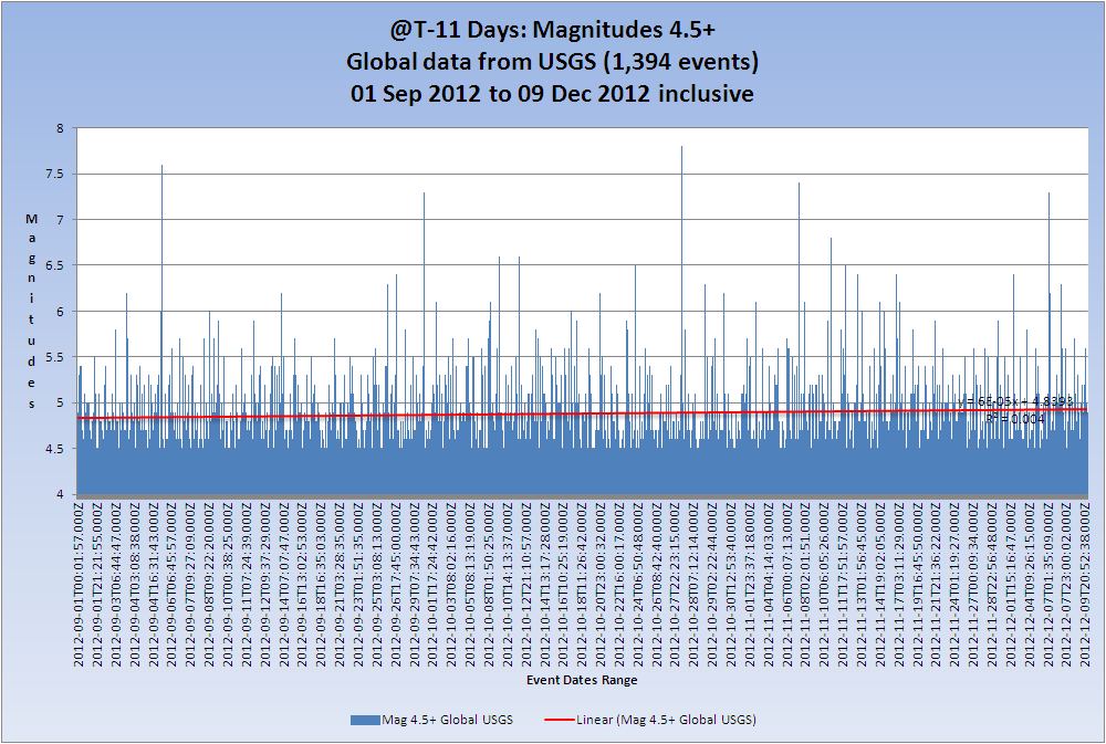
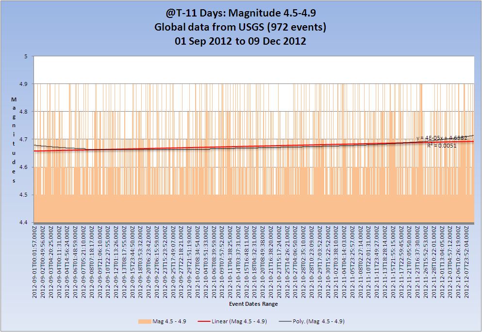
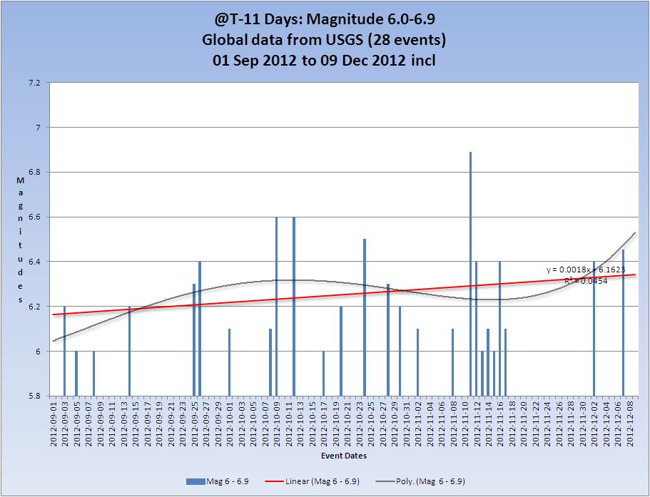
T-11 Days and counting
Earthquakes
The overall trend is still up, and the events of the 9th caused a very slight increase in the overall trend from R2=0.0039 to 0.004
Listing for the 09 December. 9 x 4.5/4.9, 6 x 5.0/5.9
Prov,Date/Time UTC,Latitude,Longitude,Magnitude,Depth(Km),Location
usgs,2012-12-09 23:56:36, 37.501, 143.831, 4.9, 34.0, Off E. Coast Of Honshu. Japan
usgs,2012-12-09 23:50:35, 37.457, 143.780, 5.0, 37.9, Off E. Coast Of Honshu. Japan
usgs,2012-12-09 23:13:21, 1.624, 89.607, 4.7, 14.7, North Indian Ocean
usgs,2012-12-09 21:45:34, 6.718, 126.183, 5.6, 56.0, Mindanao. Philippines
usgs,2012-12-09 20:52:38, -16.155, -174.224, 5.2, 129.7, Tonga
usgs,2012-12-09 19:09:32, 52.448, -170.071, 4.8, 48.3, Fox Isls.
usgs,2012-12-09 18:59:48, 37.914, 143.913, 4.9, 35.0, Off E. Coast Of Honshu. Japan
usgs,2012-12-09 18:30:07, -3.644, 141.109, 5.2, 58.4, New Guinea. P.N.G
usgs,2012-12-09 14:42:17, 37.744, 143.978, 4.8, 34.2, Off E. Coast Of Honshu. Japan
usgs,2012-12-09 12:38:40, -54.038, -1.940, 5.0, 9.9, Bouvet Island Region
usgs,2012-12-09 11:47:04, 38.172, 143.748, 4.6, 34.8, Off E. Coast Of Honshu. Japan
usgs,2012-12-09 06:03:18, 9.905, -83.930, 4.5, 24.3, Costa Rica
usgs,2012-12-09 02:50:51, -3.502, 145.357, 4.9, 34.0, Nr. N. Coast Of New Guinea. P.N.G
usgs,2012-12-09 02:34:19, 37.790, 143.590, 5.3, 30.0, Off E. Coast Of Honshu. Japan
usgs,2012-12-09 01:23:07, 37.895, 22.620, 4.5, 13.9, Southern Greece
All Magnitudes 4.5+
Mag 4.5 to 4.9
(The trend of overall magnitude is still increasing slightly which is a little curious)
Mag 5.0 to 5.9

Mag 6.0 to 6.9
Mag 7.0 to 7.9

Average energy per quake Mag 4.5+
(These merely indicate the average per quake which is only useful as a 'trend' of overall energy, which if the end is nigh should ramp up on would presume )
And each Magnitude band
Volcanoes
I have assumed that Lokon continues today untill I get further information. Tolbachik is still doing it's thing.
Volcano Chart

Australian VAAC
Commonwealth of Australia, Bureau of Meteorology VAAC
Category 1+ storms
Cat 1+ Storms Chart
BOPHA and Claudia were both active on the 9th but have subsided by the time this report was prepared (01:00 UTC 10th Dec)
That concludes the report of yesterday 09 December 2012 UTC.
Originally posted by tport17
7.1 in Indonesia
USGS
Think this is because of the Japan quake the other day?
My own opinion would be probably not. The Banda sea, and Ceram Sea are in a complex system of plates and there are many boundaries between it and Japan such that I am not sure that Japan would affect it, at least not the recent one.
As you can see from the list of M6+ quakes in the Banda Sea of the last 3 years this is not an uncommon time of year (last few months) for larger quakes here.
It is possible that some of the stress from the Japan 9.1 got transferred this way which possibly might account for the apparent increase in magnitudes, but I would not bet on it!
Prov,Date/Time UTC,Latitude,Longitude,Magnitude,Depth(Km),Location
usgs,2012-12-10 16:53:09, -6.540, 129.814, 7.1, 159.3, Banda Sea
usgs,2012-10-08 11:43:35, -4.442, 129.165, 6.1, 34.7, Banda Sea
usgs,2011-08-30 06:57:41, -6.400, 126.773, 6.8, 465.0, Banda Sea
usgs,2009-12-26 08:57:24, -5.560, 131.129, 6.0, 57.0, Banda Sea
usgs,2009-10-24 14:40:44, -6.136, 130.384, 6.9, 134.2, Banda Sea
usgs,2009-08-28 01:51:20, -7.126, 123.430, 6.8, 642.4, Banda Sea
edit on 10/12/2012 by PuterMan because: (no reason given)
My sincere apologies but the update for day 10 and counting will not be done until later, and may have to be rolled into day 9 and counting due to
personal circumstances.
The quakes for the day are as follows:
The quakes for the day are as follows:
Prov,Date/Time UTC,Latitude,Longitude,Magnitude,Depth(Km),Location
usgs,2012-12-10 22:08:06, 37.756, 143.750, 4.8, 44.3, Off E. Coast Of Honshu. Japan
usgs,2012-12-10 20:47:50, -6.485, 129.917, 5.3, 166.5, Banda Sea
usgs,2012-12-10 16:56:56, 44.956, 37.558, 4.9, 33.0, Caucasus Region. Russia
usgs,2012-12-10 16:53:09, -6.540, 129.814, 7.1, 159.3, Banda Sea
usgs,2012-12-10 15:25:46, -38.942, -72.912, 4.8, 29.7, Araucania. Chile
usgs,2012-12-10 12:43:24, 37.575, 143.554, 4.6, 34.2, Off E. Coast Of Honshu. Japan
usgs,2012-12-10 09:09:35, 37.794, 143.607, 4.9, 30.5, Off E. Coast Of Honshu. Japan
usgs,2012-12-10 08:41:41, 32.255, 141.300, 4.7, 7.0, Izu Isls. Japan Region
usgs,2012-12-10 00:09:53, 37.684, 143.754, 4.8, 33.9, Off E. Coast Of Honshu. Japan
reply to post by PuterMan
Thanks for your answer! I knew the Japan quake the other day caused more earthquakes because of the "bell ringing" around the world. I wasn't sure if this quake was just more bell ringing. Thanks for clearing it up.
Good luck with your personal issues. Hope everything works out alright.
Thanks for your answer! I knew the Japan quake the other day caused more earthquakes because of the "bell ringing" around the world. I wasn't sure if this quake was just more bell ringing. Thanks for clearing it up.
Good luck with your personal issues. Hope everything works out alright.
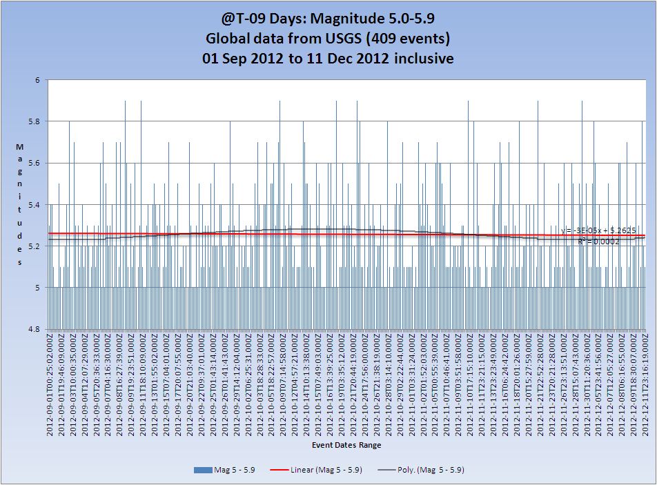
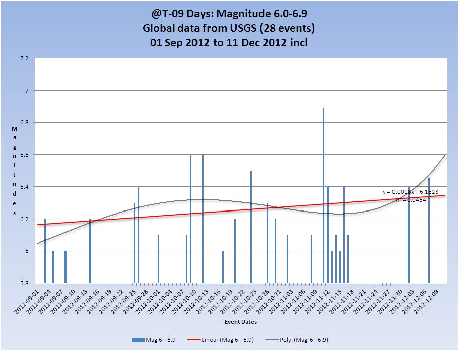
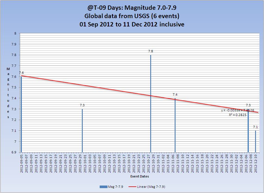
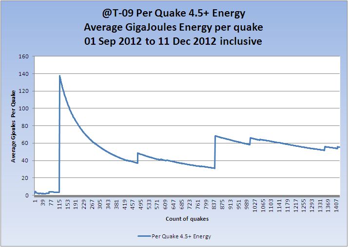
T-9 Days and counting
Earthquakes
A dearth of events in the 4.5 to 4.9 band yesterday with only 2 making the grade. Even the Mag 5 band is on the lower side of normal. It is still my opinion that we will see a Mag 7+ in the Vanuatu region before the end of the year, and possibly before the end of the world
The overall trend lifted slightly again, mainly due to the lack of Mag 4.5 - 4.9
Listing for the 11 December. 2 x 4.5/4.9, 4 x 5.0/5.9
Prov,Date/Time UTC,Latitude,Longitude,Magnitude,Depth(Km),Location
usgs,2012-12-11 23:28:04, 30.672, 140.095, 4.8, 136.0, Izu Isls. Japan Region
usgs,2012-12-11 23:16:19, -18.990, 167.790, 5.1, 10.0, Vanuatu
usgs,2012-12-11 12:18:20, -19.094, 167.624, 5.2, 28.2, Vanuatu Region
usgs,2012-12-11 06:18:27, 0.594, 126.247, 5.8, 29.7, Molucca Sea
usgs,2012-12-11 05:37:02, 14.530, 56.231, 4.8, 10.0, Owen Fracture Zone Region
usgs,2012-12-11 05:12:20, 68.135, -136.408, 5.1, 9.9, Northern Yukon Territory. Canada
All Magnitudes 4.5+
Mag 4.5 to 4.9
(The trend of overall magnitude is still increasing slightly which is a little curious)

Mag 5.0 to 5.9
Mag 6.0 to 6.9
Mag 7.0 to 7.9
Average energy per quake Mag 4.5+
(These merely indicate the average per quake which is only useful as a 'trend' of overall energy, which if the end is nigh should ramp up on would presume )
And each Magnitude band

Volcanoes
The weekly Smithsonian report will be out later so tomorrow will have better confirmed information.
I have assumed that Lokon continues today untill I get further information. Tolbachik is still doing it's thing. I posted this in Volcano Watch yesterday
Volcano Chart
Australian VAAC
Commonwealth of Australia, Bureau of Meteorology VAAC
Category 1+ storms
Cat 1+ Storms Chart
Claudia (Cat 3) continues.
Storm 4 as yet unnamed, currently south of Wallis and Futuna, is forecast to grow to Category 3 over the next few days. Current status is Tropical Storm.
Date: 11-11 DEC 2012
Tropical Storm FOUR
ADV LAT LON TIME WIND PR STAT
1 -14.30 -175.60 12/11/18Z 35 - TROPICAL STORM
+12 -13.80 -173.90 12/12/06Z 50 - TROPICAL STORM
+24 -13.20 -172.50 12/12/18Z 60 - TROPICAL STORM
+36 -13.00 -171.40 12/13/06Z 70 - CYCLONE-1
+48 -13.40 -171.50 12/13/18Z 80 - CYCLONE-1
+72 -14.80 -174.10 12/14/18Z 100 - CYCLONE-3
Source: Unisys Weather
For those of us who use proper date those are in American format.
That concludes the report of yesterday 11 December 2012 UTC.
reply to post by woogleuk
Responded on that thread.
edit on 12/12/2012 by PuterMan because: (no reason given)
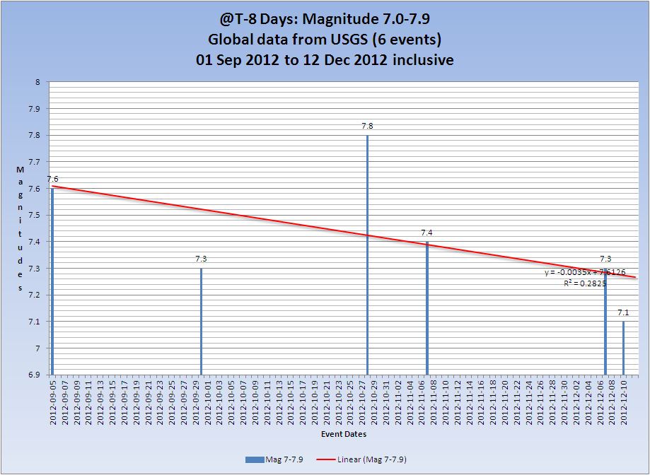
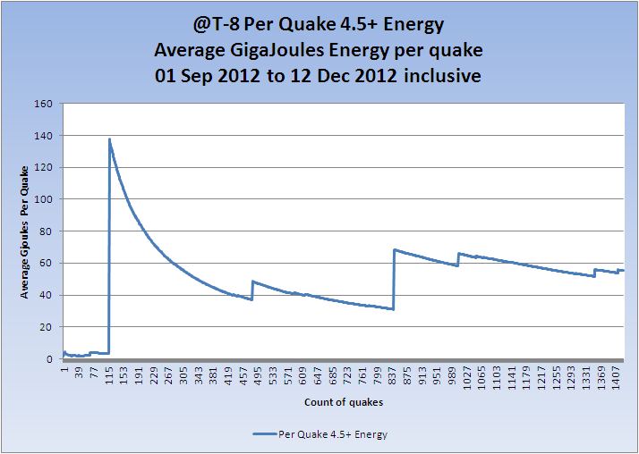
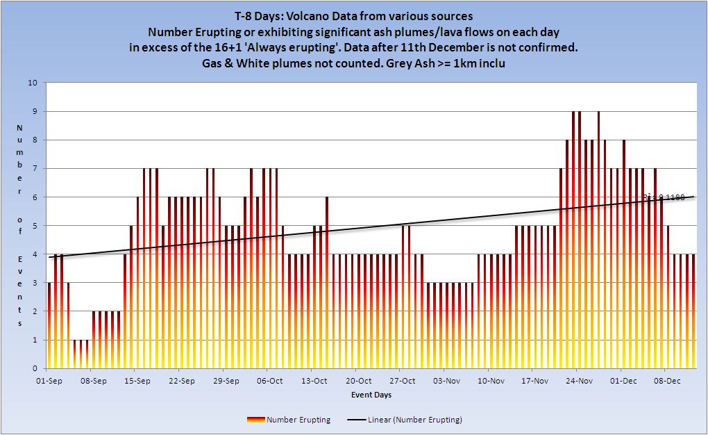
T-8 Days and counting
Earthquakes
Another dearth of events in the 4.5 to 4.9 band yesterday with only 3 making the grade and the Mag 5 band is well below normal. The calm before the end of the world perhaps?
The overall trend dropped back slightly but is still up.
Listing for the 12 December. 3 x 4.5/4.9, 1 x 5.0/5.9
Prov,Date/Time UTC,Latitude,Longitude,Magnitude,Depth(Km),Location
usgs,2012-12-12 06:54:33, 10.072, -84.386, 4.5, 10.1, Costa Rica
usgs,2012-12-12 06:41:08, 33.871, 141.218, 4.5, 66.4, Off E. Coast Of Honshu. Japan
usgs,2012-12-12 01:44:24, -19.603, -176.230, 5.0, 35.0, Fiji Region
usgs,2012-12-12 00:19:37, 37.003, 141.183, 4.8, 14.7, Nr. E. Coast Of Honshu. Japan
All Magnitudes 4.5+
Mag 4.5 to 4.9
Today saw a slight drop in the rate of upwards trend for the first time in several days.

Mag 5.0 to 5.9
The Mag 5 magnitude trend is now very slightly negative.

Mag 6.0 to 6.9
Mag 7.0 to 7.9
Average energy per quake Mag 4.5+
(These merely indicate the average per quake which is only useful as a 'trend' of overall energy, which if the end is nigh should ramp up one would presume )
And each Magnitude band
Volcanoes
Volcano Chart
KVERT reported that the eruption from Tolbachik that began on 27 November continued through 8 December. A very large thermal anomaly on the N part of Tolbachinsky Dol, a lava plateau on the SW side of the volcano, was reported daily. Lava effused from two fissures along the W side of Tolbachinsky Dol; lava had flowed 17-20 km away from the S fissure by 7 December. Ash plumes rose less than 500 m during 1-5 December, and minor ashfall was reported in Kozyrevsk (40 km NW) and Klyuchi (65 km NW) villages on 3 December. Gas-and-steam plumes drifted 250 km SE on 5 December, and rose as high as 1 km during 7-11 December and drifted SW and W. The Aviation Color Code remained at Orange.
Smithsonian
It looks as if the eruption ceased on 8th December, gas and steam not being counted. For the time bing it is considered ended.
White Island, New Zealand is showing some signs. See here
Australian VAAC
Commonwealth of Australia, Bureau of Meteorology VAAC
Category 1+ storms
New storm in the Southern Pacific (Evan) north east of Samoa and moving south west across Samoa.
Cat 1+ Storms Chart
Cyclone-1 EVAN 11-13 DEC 80 1 Active
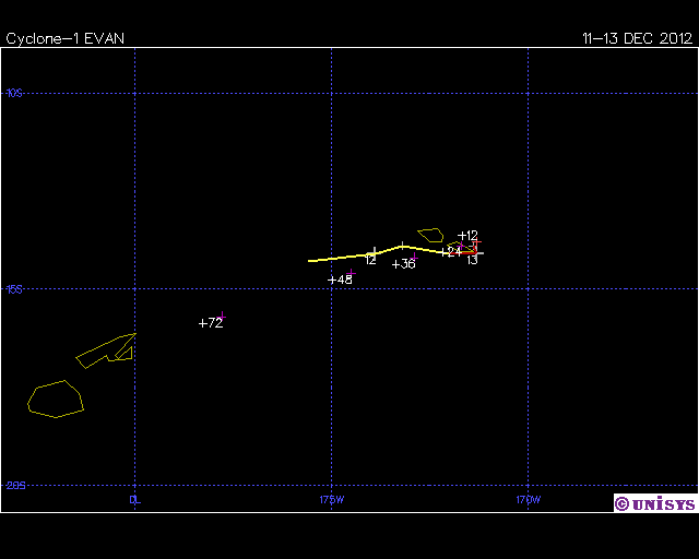
Date: 11-13 DEC 2012
Cyclone-1 EVAN
ADV LAT LON TIME WIND PR STAT
1 -14.30 -175.60 12/11/18Z 35 - TROPICAL STORM
2 -14.10 -173.90 12/12/06Z 40 - TROPICAL STORM
3 -13.90 -173.20 12/12/12Z 50 - TROPICAL STORM
4 -14.10 -172.00 12/12/18Z 65 - CYCLONE-1
5 -14.10 -171.30 12/13/00Z 80 - CYCLONE-1
6 -13.90 -171.40 12/13/06Z 80 - CYCLONE-1
+12 -13.80 -171.30 12/13/18Z 95 - CYCLONE-2
+24 -13.90 -171.70 12/14/06Z 105 - CYCLONE-3
+36 -14.20 -172.90 12/14/18Z 110 - CYCLONE-3
+48 -14.60 -174.50 12/15/06Z 110 - CYCLONE-3
+72 -15.70 -177.80 12/16/06Z 100 - CYCLONE-3
Source: Unisys weather
Not sure if this is Storm 4 mentioned yesterday as the lat/lon is a bit out but since storm 4 has gone off the list and this is the same approximate area I am certain it is the same storm.
Claudia (Cat 3) continues.
That concludes the report of yesterday 12 December 2012 UTC.
edit on 13/12/2012 by PuterMan because: (no reason given)
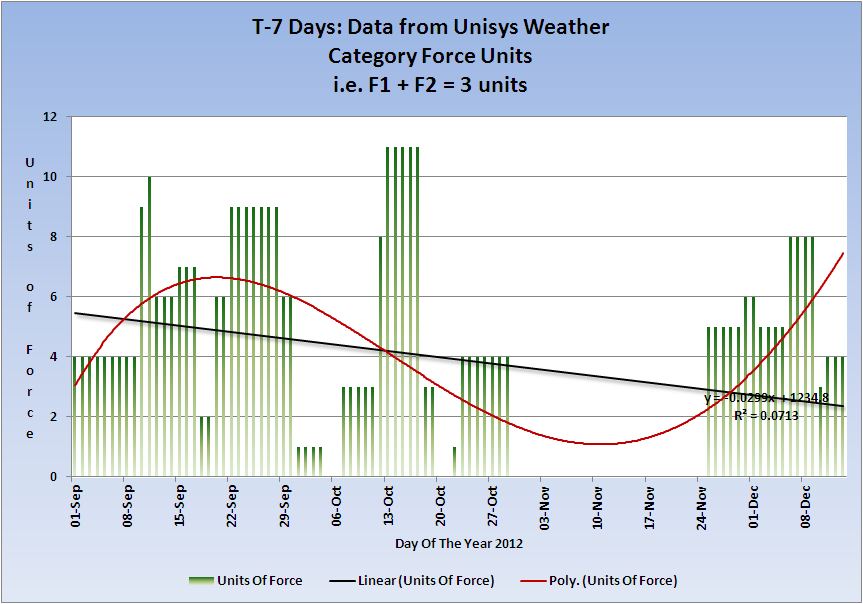
T-7 Days and counting
Earthquakes
Not many events in the 4.5 to 4.9 band yesterday with only 4 making the grade but the Mag 5 band at 4 events is back towards normal.
Listing for the 13 December. 4 x 4.5/4.9, 4 x 5.0/5.9
Prov,Date/Time UTC,Latitude,Longitude,Magnitude,Depth(Km),Location
usgs,2012-12-13 21:39:26, 41.110, 19.792, 4.5, 10.1, Albania
usgs,2012-12-13 21:26:40, 13.140, -90.004, 5.5, 13.0, Offshore El Salvador
usgs,2012-12-13 17:20:26, 9.043, -84.041, 4.9, 34.0, Costa Rica
usgs,2012-12-13 17:16:22, 9.098, -84.066, 5.0, 37.3, Costa Rica
usgs,2012-12-13 11:56:06, 35.572, 140.192, 4.6, 62.6, Nr. E. Coast Of Honshu. Japan
usgs,2012-12-13 10:02:43, 23.426, -44.753, 4.7, 10.1, Northern Mid-Atlantic Ridge
usgs,2012-12-13 00:53:32, -30.928, -178.252, 5.5, 64.9, Kermadec Isls. Nz
usgs,2012-12-13 23:03:38, 80.784, 121.561, 5.7, 9.8, East Of Severnaya Zemlya
All Magnitudes 4.5+
Mag 4.5 to 4.9
Mag 5.0 to 5.9

Mag 6.0 to 6.9

Mag 7.0 to 7.9
Average energy per quake Mag 4.5+
(These merely indicate the average per quake which is only useful as a 'trend' of overall energy, which if the end is nigh should ramp up one would presume )
And each Magnitude band
Volcanoes
Volcano Chart
KVERT reported that the eruption from Tolbachik that began on 27 November continued through 8 December. A very large thermal anomaly on the N part of Tolbachinsky Dol, a lava plateau on the SW side of the volcano, was reported daily. Lava effused from two fissures along the W side of Tolbachinsky Dol; lava had flowed 17-20 km away from the S fissure by 7 December. Ash plumes rose less than 500 m during 1-5 December, and minor ashfall was reported in Kozyrevsk (40 km NW) and Klyuchi (65 km NW) villages on 3 December. Gas-and-steam plumes drifted 250 km SE on 5 December, and rose as high as 1 km during 7-11 December and drifted SW and W. The Aviation Color Code remained at Orange.
Smithsonian
The eruption ceased on 8th December, gas and steam not being counted. For the time bing it is considered ended.
White Island, New Zealand is showing some signs. See here
Australian VAAC
Commonwealth of Australia, Bureau of Meteorology VAAC
Category 1+ storms
Evan (Southern Pacific) continues. Claudia (max Cat 3) came off the list at midnight and has subsided. Still shown in the figures for the 13th.
Cat 1+ Storms Chart
Cyclone-1 EVAN 11-13 DEC 80 1 Active
Date: 11-13 DEC 2012
Cyclone-1 EVAN
ADV LAT LON TIME WIND PR STAT
1 -14.30 -175.60 12/11/18Z 35 - TROPICAL STORM
2 -14.10 -173.90 12/12/06Z 40 - TROPICAL STORM
3 -13.90 -173.20 12/12/12Z 50 - TROPICAL STORM
4 -14.10 -172.00 12/12/18Z 65 - CYCLONE-1
5 -14.10 -171.30 12/13/00Z 80 - CYCLONE-1
6 -13.90 -171.40 12/13/06Z 80 - CYCLONE-1
+12 -13.80 -171.30 12/13/18Z 95 - CYCLONE-2
+24 -13.90 -171.70 12/14/06Z 105 - CYCLONE-3
+36 -14.20 -172.90 12/14/18Z 110 - CYCLONE-3
+48 -14.60 -174.50 12/15/06Z 110 - CYCLONE-3
+72 -15.70 -177.80 12/16/06Z 100 - CYCLONE-3
Source: Unisys weather
That concludes the report of yesterday 13 December 2012 UTC.
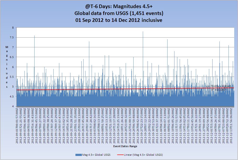
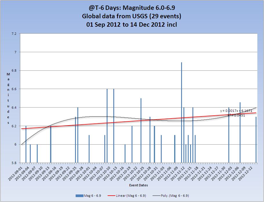
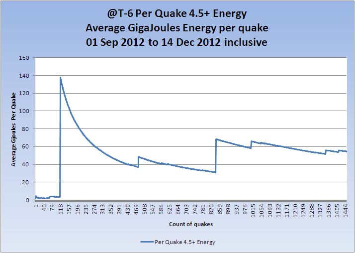
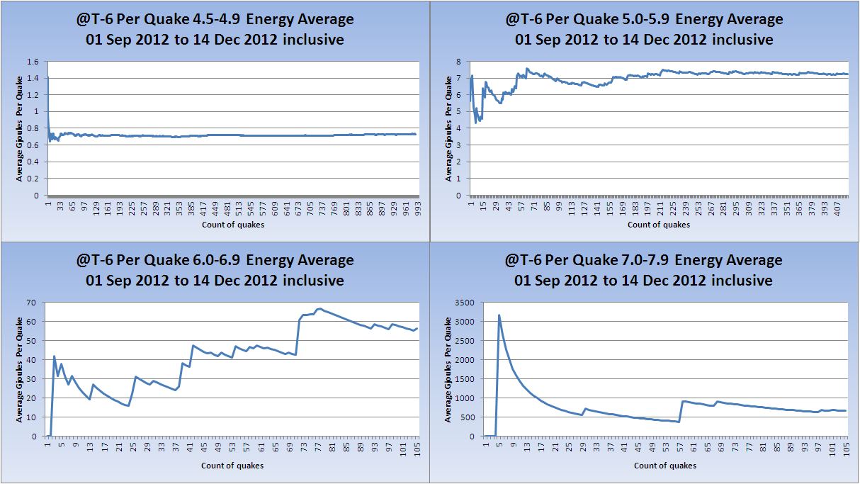
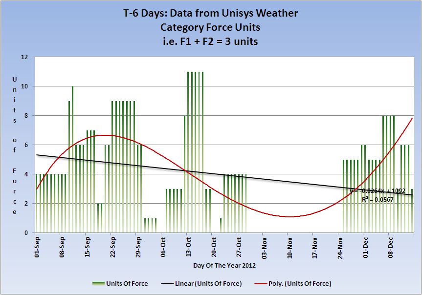
T-6 Days and counting
Earthquakes
Definitely back to normal now - or ramping up?
Listing for the 14 December. 9 x 4.5/4.9, 5 x 5.0/5.9, 1 x 6.0/6.9
Prov,Date/Time UTC,Latitude,Longitude,Magnitude,Depth(Km),Location
usgs,2012-12-14 22:37:24, -6.229, 130.182, 4.8, 133.9, Banda Sea
usgs,2012-12-14 20:37:19, 38.625, 142.334, 4.8, 53.9, Nr. E. Coast Of Honshu. Japan
usgs,2012-12-14 19:18:57, 13.011, -89.982, 4.8, 69.0, Offshore El Salvador
usgs,2012-12-14 17:46:45, -5.258, 153.412, 5.1, 36.7, New Ireland Region. P.N.G
usgs,2012-12-14 16:52:38, -15.368, -178.106, 5.3, 10.0, Fiji Region
usgs,2012-12-14 16:16:21, -7.797, 105.782, 4.8, 31.6, Java. Ind.
usgs,2012-12-14 10:50:15, 31.236, -119.695, 4.7, 9.8, Off W. Coast Of Baja California
usgs,2012-12-14 10:36:02, 31.213, -119.559, 6.3, 11.3, Off W. Coast Of Baja California
usgs,2012-12-14 09:55:44, -19.028, 169.540, 4.6, 9.9, Vanuatu
usgs,2012-12-14 05:07:04, 37.522, 143.794, 4.7, 33.4, Off E. Coast Of Honshu. Japan
usgs,2012-12-14 04:58:51, 14.012, -91.764, 5.1, 45.9, Offshore Guatemala
usgs,2012-12-14 04:04:08, 13.956, -91.740, 5.2, 45.6, Offshore Guatemala
usgs,2012-12-14 02:34:53, -5.017, 152.943, 5.1, 52.5, New Britain Region. P.N.G
usgs,2012-12-14 02:17:33, 22.750, 95.902, 4.7, 23.5, Myanmar
usgs,2012-12-14 01:22:05, 37.429, 143.546, 4.9, 39.8, Off E. Coast Of Honshu. Japan
One mag 6+
Magnitude 6.3 - Off The West Coast Of Baja California
Location in Google Maps
- Date-Time: Friday, December 14, 2012 @ 10:36:02 UTC
- Earthquake location: 31.213°N, 119.560°W,
- Earthquake depth: 11.3 km
- Distances:
263km (163mi) SSW of Avalon, California
269km (167mi) WSW of Rosarito, Mexico
276km (171mi) WSW of Imperial Beach, California
277km (172mi) SW of Coronado, California
746km (463mi) WSW of Phoenix, Arizona
- Event ID: usc000e9sl
Derived from Event Data Source: USGS
Powered by QVSData
All Magnitudes 4.5+
Mag 4.5 to 4.9

Mag 5.0 to 5.9

Mag 6.0 to 6.9
Mag 7.0 to 7.9

Average energy per quake Mag 4.5+
(These merely indicate the average per quake which is only useful as a 'trend' of overall energy, which if the end is nigh should ramp up one would presume )
And each Magnitude band
Volcanoes
Volcano Chart

Australian VAAC
Commonwealth of Australia, Bureau of Meteorology VAAC
Category 1+ storms
Evan (max Cat 3) came off the list and has subsided which is earlier than forecast. Still shown in the figures for the 14th.
Cat 1+ Storms Chart
Cyclone-3 EVAN 11-14 DEC 80 1
That concludes the report of yesterday 14 December 2012 UTC.
edit on 15/12/2012 by PuterMan because: (no reason given)
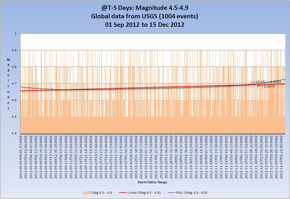
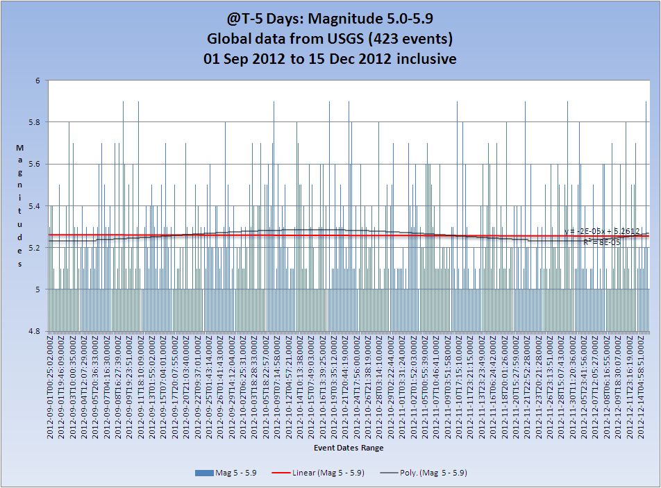
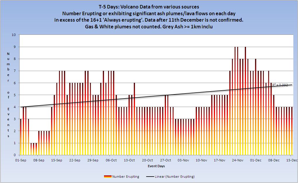
T-5 Days and counting
The tension! Will it won't it? Will some folks have to wait for their doom until the 22nd because of the time zones?
Earthquakes
Listing for the 15 December. 7 x 4.5/4.9, 4 x 5.0/5.9, 1 x 6.0/6.9
Prov,Date/Time UTC,Latitude,Longitude,Magnitude,Depth(Km),Location
usgs,2012-12-15 21:23:44, 37.603, 143.784, 4.8, 34.1, Off E. Coast Of Honshu. Japan
usgs,2012-12-15 19:30:03, -4.724, 152.963, 6.0, 55.8, New Britain Region. P.N.G
usgs,2012-12-15 19:16:50, -3.504, 100.452, 4.9, 15.1, Kepulauan Mentawai Region. Ind.
usgs,2012-12-15 13:03:27, 13.204, -89.857, 4.5, 74.4, Offshore El Salvador
usgs,2012-12-15 12:43:29, 12.134, -88.700, 5.0, 34.6, Off Coast Of El Salvador
usgs,2012-12-15 10:55:25, 37.602, 143.745, 4.8, 35.4, Off E. Coast Of Honshu. Japan
usgs,2012-12-15 08:53:35, -23.976, -66.816, 4.5, 204.9, Jujuy. Argentina
usgs,2012-12-15 07:33:14, -4.924, 153.378, 5.2, 58.2, New Ireland Region. P.N.G
usgs,2012-12-15 05:46:15, 36.797, 141.127, 4.8, 45.3, Nr. E. Coast Of Honshu. Japan
usgs,2012-12-15 04:49:30, 52.344, 173.964, 5.9, 29.9, Nr. Isls.
usgs,2012-12-15 04:27:02, 37.348, 141.286, 5.2, 57.8, Nr. E. Coast Of Honshu. Japan
usgs,2012-12-15 01:03:36, -8.624, 120.416, 4.5, 126.4, Flores Region. Ind.
One mag 6+
Magnitude 6.0 - New Britain Region. Papua New Guinea
Location in Google Maps
- Date-Time: Saturday, December 15, 2012 @ 19:30:03 UTC
- Earthquake location: 4.724°S, 152.964°E,
- Earthquake depth: 55.8 km
- Distances:
29km (18mi) SSW of Taron, PNG
87km (54mi) ESE of Kokopo, Papua New Guinea
325km (201mi) ENE of Kimbe, Papua New Guinea
329km (204mi) WNW of Arawa, Papua New Guinea
824km (512mi) NE of Port Moresby, Papua New Guinea
- Event ID: usc000eacu
Derived from Event Data Source: USGS
Powered by QVSData
All Magnitudes trend 4.5+

Mag 4.5 to 4.9 magnitudes trend.
Mag 5.0 to 5.9 magnitudes trend.
Mag 6.0 to 6.9 magnitudes trend.
Mag 7.0 to 7.9 magnitudes trend.
Average energy per quake Mag 4.5+
(These merely indicate the average per quake which is only useful as a 'trend' of overall energy, which if the end is nigh should ramp up one would presume )
And each Magnitude band
Volcanoes
Volcano Chart
Australian VAAC
Commonwealth of Australia, Bureau of Meteorology VAAC
Category 1+ storms
Evan (max Cat 3) was an error yesterday. They should not have taken the active status off. It is back on today.
Cat 1+ Storms Chart
Cyclone-3 EVAN 11-15 DEC 80 1
That concludes the report of yesterday 15 December 2012 UTC.
new topics
-
University of Texas Instantly Shuts Down Anti Israel Protests
Education and Media: 1 hours ago -
Any one suspicious of fever promotions events, major investor Goldman Sachs card only.
The Gray Area: 3 hours ago -
God's Righteousness is Greater than Our Wrath
Religion, Faith, And Theology: 7 hours ago -
Electrical tricks for saving money
Education and Media: 10 hours ago
top topics
-
VP's Secret Service agent brawls with other agents at Andrews
Mainstream News: 12 hours ago, 10 flags -
Cats Used as Live Bait to Train Ferocious Pitbulls in Illegal NYC Dogfighting
Social Issues and Civil Unrest: 16 hours ago, 8 flags -
Nearly 70% Of Americans Want Talks To End War In Ukraine
Political Issues: 13 hours ago, 4 flags -
Electrical tricks for saving money
Education and Media: 10 hours ago, 4 flags -
Sunak spinning the sickness figures
Other Current Events: 12 hours ago, 3 flags -
Late Night with the Devil - a really good unusual modern horror film.
Movies: 14 hours ago, 2 flags -
Any one suspicious of fever promotions events, major investor Goldman Sachs card only.
The Gray Area: 3 hours ago, 2 flags -
God's Righteousness is Greater than Our Wrath
Religion, Faith, And Theology: 7 hours ago, 0 flags -
University of Texas Instantly Shuts Down Anti Israel Protests
Education and Media: 1 hours ago, 0 flags
active topics
-
President BIDEN Vows to Make Americans Pay More Federal Taxes in 2025 - Political Suicide.
2024 Elections • 137 • : CriticalStinker -
I think this life means something.
Philosophy and Metaphysics • 59 • : seekshelter -
Late Night with the Devil - a really good unusual modern horror film.
Movies • 5 • : chiefsmom -
Nearly 70% Of Americans Want Talks To End War In Ukraine
Political Issues • 33 • : andy06shake -
Sunak spinning the sickness figures
Other Current Events • 11 • : McUrnsalso -
Any one suspicious of fever promotions events, major investor Goldman Sachs card only.
The Gray Area • 6 • : ImagoDei -
University of Texas Instantly Shuts Down Anti Israel Protests
Education and Media • 1 • : PorkChop96 -
Reason of the Existence
The Gray Area • 20 • : belkide -
Black mirror, what happened.
Television • 20 • : seekshelter -
God's Righteousness is Greater than Our Wrath
Religion, Faith, And Theology • 25 • : andy06shake