It looks like you're using an Ad Blocker.
Please white-list or disable AboveTopSecret.com in your ad-blocking tool.
Thank you.
Some features of ATS will be disabled while you continue to use an ad-blocker.

Scientists 'Undiscover' Pacific Island
page: 6share:
Weird.
Well, for what it’s worth, all I can say is that as a sailor myself who has spent 20 years on the water all over the world including French Polynesia, the Cook’s, and the Solomon’s, I can tell you two things for sure about this:
1. The inclusion of this relatively large island was NOT a map-maker’s “trap” or copyright trick. This practice might occur in geographical cartography, but I can assure you this would NEVER be done in modern nautical charts. The lives of sailors and passengers have (until recently) relied too heavily on the accuracy of nautical charts to ever allow for such a frivolous practice. Charts and maps are frequently updated to make even the most trivial of corrections. To ignore an intentionally misrepresented island 20 miles by 5 miles long would be the biggest scandal in the history of nautical maps I should think.
2. 1,400 meters (about 4,600 feet) is too deep for any small island to exist or probably ever have existed. The ascending shelf required to accommodate an island supposedly 100 square miles in area would itself have to be several thousand square miles in its rise from the sea floor, something that simply does not exist at that location. One can safely assume that a collapse or geologic event on the magnitude of what would have had to occur to leave a 1,400 meter hole in the ocean would be so massive every seismic detection tool on the planet would have registered it.
Punching the coordinates into my Garmin I can confirm that there is indeed nothing there. There are a grouping of tiny unnamed atolls about 50 nm west, and the northern tip of New Caledonia lies about 200 nm east, but in between that, nothing but deep, deep water.
There is a rather strange anomaly on the ocean floor where Sandy Island was supposed to have been. I’m going to give that a good look going forward. But to conclude some geological event occurred in recent times that caused a 100 square mile island to simply vanish without anyone knowing is ludicrous.
The most logical explanation…? I don’t know. As I stated above, the first thing that occurred to me was “weird!”. I do not think this was an intentional or accidental cartographic mistake, even though logic tells me it HAD TO BE. If so, that's the first time I’ve ever heard of either a mistake this big being repeated over and over again, or an intentional inclusion meant to thwart copyright violators that was promulgated time and time again by others.
The bottom line is, if it wasn’t a mistake on a map, and no geographical event took place to destroy the island, there must have been something there at some point in recent history.
If so, where did it go?
Was it an island at all…?
Weird...
reply to post by lewman
There iss no way it could be a nuclear testing ground as it is too close to New Caledonia as well as the Great Barrier Reef. The radiation from a nuclear weapon could easily reach either place and injure or kill people or the environment.
There iss no way it could be a nuclear testing ground as it is too close to New Caledonia as well as the Great Barrier Reef. The radiation from a nuclear weapon could easily reach either place and injure or kill people or the environment.
reply to post by ZakOlongapo
That pic looks like you sunk my battleship!!!!
That pic looks like you sunk my battleship!!!!
edit on 23-11-2012 by LightSource because: (no reason given)
reply to post by shauny
Yea, I don't own a GPS. Why would I pay for something to get me lost, I can get lost fine all by myself.
Yea, I don't own a GPS. Why would I pay for something to get me lost, I can get lost fine all by myself.
Seems like a good way to hide an island for nefarious activities.
You can search and find some old satellite or aerial photos on the USGS Earth Explorer. Just search the
coordinates to verify. Most have cloud cover, but a few are fairly clear. No sign of an island as far as I could see.
I guess they missed eliminating some traces of it on a few maps in this timeline though. Only half kidding on that...
I guess they missed eliminating some traces of it on a few maps in this timeline though. Only half kidding on that...
Just speculation and I doubt its true but imagine if the island existed and it had prime conditions for some time of test that needed to be kept from
the public. Imagine if they spewed a bunch of propaganda to convince people the island never existed and block it out from all online sites so they
can freely do X testing there.
Like breed a race of super humans to slowly mate with regular humans and create a new race that is able to colonize space and survive in any climate
(just kidding)
Like breed a race of super humans to slowly mate with regular humans and create a new race that is able to colonize space and survive in any climate
(just kidding)
reply to post by SBMcG
I thought the same, you can see some low lying elevation on the map but nothing significant enough to raise and hold an island. To me this does seem extremely odd, when was this island put into the data-base? When was this island 'discovered' and by whom? This information is usually common knowledge but with this instance it isn't. There seems to be more to this, what exactly that is I haven't the slightest idea.
I thought the same, you can see some low lying elevation on the map but nothing significant enough to raise and hold an island. To me this does seem extremely odd, when was this island put into the data-base? When was this island 'discovered' and by whom? This information is usually common knowledge but with this instance it isn't. There seems to be more to this, what exactly that is I haven't the slightest idea.
Other questions that are important to ask:
Was it a test of some sort? It could have been added in to see how long it goes unnoticed.
Are the people responsible just gauging the public's reaction? They could just be seeing how everyone reacts to something like this.
Why has this come to light at this specific point in time? It could be a distraction of some sort or there could be a reason that it has been discovered right now.
What else is going on with maps/islands/the sea that could give someone a reason to do this?
Is it to implant the idea that maps can be incorrect and a disappearing island is nothing to be alarmed about? This could help in the future if they need to make an island disappear.
Is this going to be used as a reason to do something else? Possibly sending something out to the island, or to start up new research.
Who could gain something from this?
reply to post by NoJoker13
I have a good friend who collects old nautical charts and I have been texting him about this. Unfortunately (for us anyway), he's a commercial airline pilot on a trip and doesn't have access to his collection right now. He'll be home on Tuesday, so we shall see.
Personally, I don't know if a proper Imray-type chart exists for that remote region. He thinks he has a really old one that shows Sandy Island, but he's not sure. I'm DYING to know, because if he has the actual chart showing the island, it's either one of the biggest screw-ups of nautical cartography in modern times, or we have a real mystery on our hands.
As you said, though there is a noticeable sea floor anomaly beneath the location, there's no way that there was a geological event creating a 1,400 meter hole in the ocean and nobody heard a thing...
Originally posted by lewman
Could it have been a possible nuclear testing ground and it is now merely an underwater crater.
Other than the official story, this is the first thing that popped into my head as well. The only thing I'd change is the "nuclear" part. Considering how the black world is theoretically 30+ years ahead of the mainstream - who even knows what sort of weapons they are testing under wraps at this point? It's a weird one either way.
reply to post by lavenlaar
There have been other documented cases of islands surfacing then disappearing again under the sea. Many islands are nothing but huge volcanic bubbles whose height can indeed vary by one or two hundred feet due to volcanic action or the collapse of those bubbles or movement of the crust in the manner of earthquakes. It is enough to make them appear above the water then disappear under it. Sorry, I don't remember the details.
There have been other documented cases of islands surfacing then disappearing again under the sea. Many islands are nothing but huge volcanic bubbles whose height can indeed vary by one or two hundred feet due to volcanic action or the collapse of those bubbles or movement of the crust in the manner of earthquakes. It is enough to make them appear above the water then disappear under it. Sorry, I don't remember the details.
Originally posted by sorgfelt
reply to post by lavenlaar
There have been other documented cases of islands surfacing then disappearing again under the sea. Many islands are nothing but huge volcanic bubbles whose height can indeed vary by one or two hundred feet due to volcanic action or the collapse of those bubbles or movement of the crust in the manner of earthquakes. It is enough to make them appear above the water then disappear under it. Sorry, I don't remember the details.
ok so sandy island is not alone according to wikipedia
new moore island
bermeja island
add to the list here
some believe there maybe a H.A.A.R.P. twist in play as if these islands are being tested by tesla's deathray capabilities haarp may possess
but yea...a couple more names of islands to add to the list
new moore and bermeja
perhaps this old legend is where the series "lost" gets its storyline. Is it Haarp or some kind of electromagnetic anomaly? I wish I knew
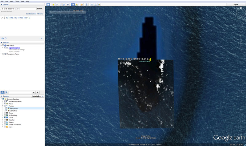
This is pretty interesting. There is clearly some kind of shelf or something so its possible something "was" there. But what I find odd is that
everything seems "blacked" out. Why does it look like someone took a black photoshop brush to it?! If there's nothing there..then the whole "tile"
would be deleted or more likely...would be updated. I usually debunk the conspiracies or at least try to...but this one just smells fishy...no pun
intended. Here's a capture I did that clearly shows a dark object or mass in that area. What is it? Oil, top of a shelf, coral, algae?
edit on 26-11-2012 by Apocalyptic because: (no reason given)
Originally posted by Iam'___'
I like some of the explanations on here but whether it existed/exists or not, why the blackout on google?
That just makes it really odd.
that was my thinking....why not just fill it in with the blue sea water backround??...instead it is still outlined AND blacked out.
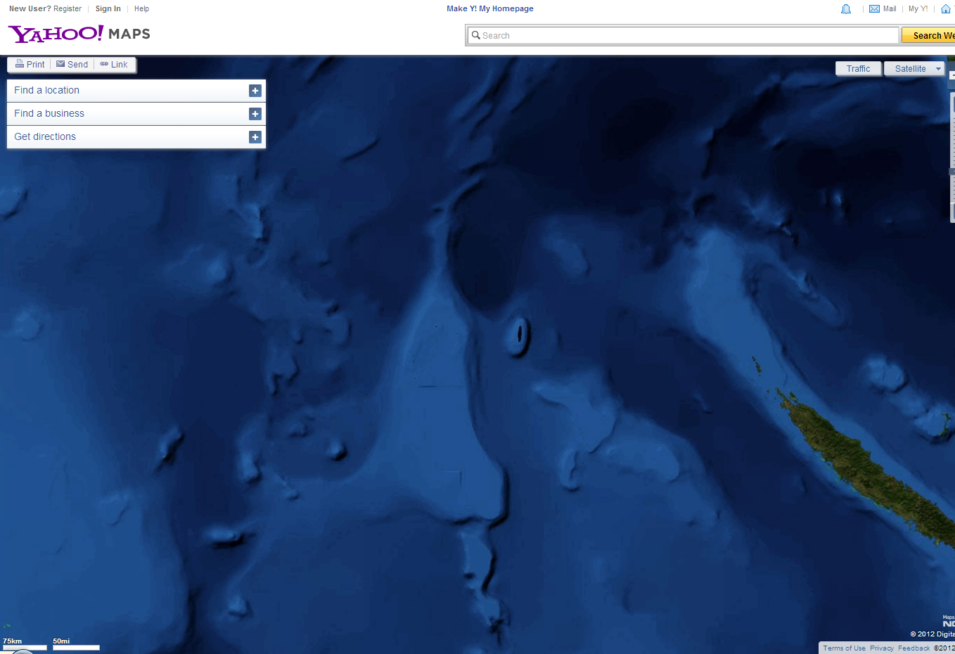
Here is yahoo maps...it shows the elevation rise so it is possible there is some land above the water...
See my image above. I'm able to see some region in google earth just south of the painted out area. What is that? Nowhere else on ocean
maps/images do you see this. Its like its been quickly removed. I'm sure it will be replaced with "solid" ocean at some point soon.
reply to post by Apocalyptic
Great work, pretty insane, I saw someone say the elevation couldn't support an island... clearly it can. Great work on the photo, amazing work actually.
Great work, pretty insane, I saw someone say the elevation couldn't support an island... clearly it can. Great work on the photo, amazing work actually.
Thanks. I'm thinking it was above water at some point...maybe a very shallow atoll that is now just a reef...hence the dark shadow effect in the
older portion of the image. This is part of the great barrier reef I think so its possible. I just don't think a simple "error" occurred. Just
strange why its painted out so poorly.
new topics
-
George Knapp AMA on DI
Area 51 and other Facilities: 3 hours ago -
Not Aliens but a Nazi Occult Inspired and then Science Rendered Design.
Aliens and UFOs: 3 hours ago -
Louisiana Lawmakers Seek to Limit Public Access to Government Records
Political Issues: 6 hours ago -
The Tories may be wiped out after the Election - Serves them Right
Regional Politics: 7 hours ago -
So I saw about 30 UFOs in formation last night.
Aliens and UFOs: 9 hours ago -
Do we live in a simulation similar to The Matrix 1999?
ATS Skunk Works: 10 hours ago -
BREAKING: O’Keefe Media Uncovers who is really running the White House
US Political Madness: 10 hours ago -
Biden--My Uncle Was Eaten By Cannibals
US Political Madness: 11 hours ago -
"We're All Hamas" Heard at Columbia University Protests
Social Issues and Civil Unrest: 11 hours ago
top topics
-
BREAKING: O’Keefe Media Uncovers who is really running the White House
US Political Madness: 10 hours ago, 23 flags -
George Knapp AMA on DI
Area 51 and other Facilities: 3 hours ago, 18 flags -
Biden--My Uncle Was Eaten By Cannibals
US Political Madness: 11 hours ago, 18 flags -
African "Newcomers" Tell NYC They Don't Like the Free Food or Shelter They've Been Given
Social Issues and Civil Unrest: 16 hours ago, 12 flags -
"We're All Hamas" Heard at Columbia University Protests
Social Issues and Civil Unrest: 11 hours ago, 7 flags -
Louisiana Lawmakers Seek to Limit Public Access to Government Records
Political Issues: 6 hours ago, 7 flags -
Russian intelligence officer: explosions at defense factories in the USA and Wales may be sabotage
Weaponry: 16 hours ago, 6 flags -
So I saw about 30 UFOs in formation last night.
Aliens and UFOs: 9 hours ago, 5 flags -
The Tories may be wiped out after the Election - Serves them Right
Regional Politics: 7 hours ago, 3 flags -
Not Aliens but a Nazi Occult Inspired and then Science Rendered Design.
Aliens and UFOs: 3 hours ago, 3 flags
active topics
-
So I saw about 30 UFOs in formation last night.
Aliens and UFOs • 20 • : Halfswede -
Candidate TRUMP Now Has Crazy Judge JUAN MERCHAN After Him - The Stormy Daniels Hush-Money Case.
Political Conspiracies • 375 • : WeMustCare -
MULTIPLE SKYMASTER MESSAGES GOING OUT
World War Three • 33 • : Halfswede -
-@TH3WH17ERABB17- -Q- ---TIME TO SHOW THE WORLD--- -Part- --44--
Dissecting Disinformation • 530 • : cherokeetroy -
George Knapp AMA on DI
Area 51 and other Facilities • 12 • : theshadowknows -
Not Aliens but a Nazi Occult Inspired and then Science Rendered Design.
Aliens and UFOs • 7 • : JonnyC555 -
Mood Music Part VI
Music • 3057 • : BatCaveJoe -
The Tories may be wiped out after the Election - Serves them Right
Regional Politics • 19 • : alwaysbeenhere2 -
"We're All Hamas" Heard at Columbia University Protests
Social Issues and Civil Unrest • 125 • : KrustyKrab -
Biden--My Uncle Was Eaten By Cannibals
US Political Madness • 40 • : Kaiju666