It looks like you're using an Ad Blocker.
Please white-list or disable AboveTopSecret.com in your ad-blocking tool.
Thank you.
Some features of ATS will be disabled while you continue to use an ad-blocker.

Scientists 'Undiscover' Pacific Island
page: 4share:
Originally posted by alfa1
Originally posted by lavenlaar
Like to hear you opinions
Many mapmakers put in deliberate but unobtrusive and non obvious "mistakes" into the thir maps so that they can know when somebody steals the map data.
This may just go back to somebody doing this in the past, and that data has lived on through further copies.
Read, for example, this wikipedia page on Fictitious Entry.
Yes but placing a entire non-existing island on the map is not exactly unobtrusive or non-obvious to be terribly honest. Signature mistakes are only meant to be recognized by the maker , it is their sole function. It has no need to be seen noticed by others. Why would one draw a entire island for this purpose ?
no,it must be this:
Whoop there it is
Remember Australia is where Pine Gap is located and was also the place where that STS 48 Projectile was fired from that shot at that UFO flying. As
soon as the projectile was fired from Pine Gap that UFO is seen Punching at MACH 128 out to space.. This is all picked up by the space shuttle's
camera... After this was picked up by the masses all Space shuttle Video broadcasts have a delay BEFORE the public gets to see it.. I have always
thought that the Airforce does alot of their test flying for their newest flying machines..
reply to post by lavenlaar
Maybe this land mass has lowered itself under the ocean? Has anyone tried using any techniques to see the land forms under the surface water. If it were any part of any volcanic cone its possible that it collapsed onto itself and dipped below the water.
If it were part of any military installation now off limits they wouldnt even allow ships to sail close by.
Unless its actually the famous Floating Island and is now in a different location.
Not much to add other than its not often our beloved ATS and its membership is quoted by the MSM. Here's the story on this missing island with ATS
quote in The Daily Mail (say what you will about the DM but its a legit news source and I believe the most highly trafficked on the Web):
www.dailymail.co.uk...
age.html
Very strange. I've been trying to find old satellite photos of 19 degrees 13' 18.18" S 159 degrees 56' 13.54" E and have not been able to. In
this day and age, you would think that every square inch of the planet must have decades of satellite photos to look back on.
Anybody able to find any?
Anybody able to find any?
Now, would it not be great if this phenomenon was to occur for the disputed Senkaku Islands between Japan and China.
Originally posted by Jason88
Not much to add other than its not often our beloved ATS and its membership is quoted by the MSM. Here's the story on this missing island with ATS quote in The Daily Mail (say what you will about the DM but its a legit news source and I believe the most highly trafficked on the Web): www.dailymail.co.uk... age.html
lolllllllll, the dailymail reads ATS.
Looks like ATS and this post has gone viral
Phys.org - phys.org...
DailyMail - www.dailymail.co.uk... age.html
NEWS.com.au
www.news.com.au... 1
the Huffington Post
www.huffingtonpost.co.uk...
Wort.lu (Luxemburg)
www.wort.lu...
Yahoo News Canada
ca.news.yahoo.com...
Perth NOW
www.perthnow.com.au... 365171
ABC news
www.abc.net.au...
Arab news
www.arabnews.com...
a new Wikipedia entry
en.wikipedia.org...
and many many more
www.google.com.au...:en-GBfficial&client=firefox-a&source=hp& channel=np#q=abovetopsecret+sandy+island&hl=en&client=firefox-a&tbo=d&rls=org.mozilla:en-GBfficial&channel=np&ei=M7euUP_JKeSfiAfIzID4Ag&start=0&sa=N &bav=on.2,or.r_gc.r_pw.r_qf.&fp=1bf8971734a1165e&bpcl=38897761&biw=1024&bih=626
This is the first time I have ever seen this website referenced in mainstream media
All because of this island....
I wonder what the Daily Mail Readership / General public will make of this site. I hope some visit and get enlightened about various things.
But Hello Journalists DAMIEN GAYLE and MARK DUELL from the Daily Mail.
How about you have a good read over this website and help inform the public over the truth about some other subjects that are repeatedly covered up / ignored or subject to disinformation. I'm sure the members here could put together a top ten of most important things that we wish the rest of the public knew!
Nice to know that you people visit here though!
What this does show is that the incredible research by forum members here is being recognised!
On www.abovetopsecret.com, discussions were robust with one poster claiming he had confirmed with the French hydrographic office that it was indeed a phantom island and was supposed to have been removed from charts in 1979.
Another claimed: 'Many mapmakers put in deliberate but unobtrusive and non-obvious "mistakes" into their maps so that they can know when somebody steals the map data.'
www.dailymail.co.uk... age.html
All because of this island....
I wonder what the Daily Mail Readership / General public will make of this site. I hope some visit and get enlightened about various things.
But Hello Journalists DAMIEN GAYLE and MARK DUELL from the Daily Mail.
How about you have a good read over this website and help inform the public over the truth about some other subjects that are repeatedly covered up / ignored or subject to disinformation. I'm sure the members here could put together a top ten of most important things that we wish the rest of the public knew!
Nice to know that you people visit here though!
What this does show is that the incredible research by forum members here is being recognised!
edit on 22-11-2012 by Loopdaloop because: (no
reason given)
I wonder how many times that island has changed hands "sight unseen". Somebody should check with the real estate agents in the area.
Looks like ATS made yahoo news
au.news.yahoo.com... undiscover-island/
cant get more mainstream than that
News of the invisible island sparked debate on social media, with Twitter user Charlie Loyd pointing out that Sandy Island is also on Yahoo Maps as well as Bing Maps "but it disappears up close". On www.abovetopsecret.com, discussions were robust with one poster claiming he had confirmed with the French hydrographic office that it was indeed a phantom island and was supposed to have been removed from charts in 1979. Another claimed: "Many mapmakers put in deliberate but unobtrusive and non-obvious 'mistakes' into their maps so that they can know when somebody steals the map data."
au.news.yahoo.com... undiscover-island/
cant get more mainstream than that
edit on 22-11-2012 by TiM3LoRd because: (no reason given)
Neither the French government - the invisible island would sit within French territorial waters if it existed - nor the ship's nautical charts, which are based on depth measurements, had the island marked on their maps. Read more: www.smh.com.au...
The French did nuclear testing the the Pacific sit it "would sit inside French territorial waters.
My guess the blew it up!
If they didn't maybe the tsunami that got Japan ate it.
If it was a sand Island then it has just been eroded away and the sand has collected some where else.
If it wasn't a sand island it was probably towed to a secret location somewhere out of range of google
If it wasn't a sand island it was probably towed to a secret location somewhere out of range of google
Well it seems that the island existed at some point in time as i have come across pictures of it which i will post.
The area around the map seems strange as does the stitching of the images around the area.
Visible on the island are trees and there is another larger island towards the lower left of it.
Although the island does look like a sand spit which may have simply eroded over time, This does not explain why google have it blacked out nor why it is now being said that the island may have never existed. Surely if there are pictures of it, Something must have existed at some point.
All in all pretty interesting but probably not something to write home about, Amazed by how much attention this has gotten everywhere.


Just thought id make these images and coordinates available.
Hope we can find the conclusion to this enigmatic mystery soon
The area around the map seems strange as does the stitching of the images around the area.
Visible on the island are trees and there is another larger island towards the lower left of it.
Although the island does look like a sand spit which may have simply eroded over time, This does not explain why google have it blacked out nor why it is now being said that the island may have never existed. Surely if there are pictures of it, Something must have existed at some point.
All in all pretty interesting but probably not something to write home about, Amazed by how much attention this has gotten everywhere.
Just thought id make these images and coordinates available.
Hope we can find the conclusion to this enigmatic mystery soon
reply to post by spacedoubt
Why call it Madoff Island and call it Brigadoon?
Perhaps some stranded sailors found paradise and it disappeared, then reappeared a couple hundred years later for the next victims?
Why call it Madoff Island and call it Brigadoon?
Perhaps some stranded sailors found paradise and it disappeared, then reappeared a couple hundred years later for the next victims?
edit on
22-11-2012 by TheToastmanCometh because: add
Originally posted by AsanoSuigin
Well it seems that the island existed at some point in time as i have come across pictures of it which i will post.
Just thought id make these images and coordinates available.
Your sandy island is at 23 degrees south, 130 degrees west,
the missing sandy island is at 19 degrees south, 159 degrees east.
But I'd just like to express my shame at being quoted in the Dail Mail. Oh, the ignominity.
How will I ever hold my head up in public again? What will my friends at the golf club say?
Originally posted by alfa1
Originally posted by AsanoSuigin
Well it seems that the island existed at some point in time as i have come across pictures of it which i will post.
Just thought id make these images and coordinates available.
Your sandy island is at 23 degrees south, 130 degrees west,
the missing sandy island is at 19 degrees south, 159 degrees east.
But I'd just like to express my shame at being quoted in the Dail Mail. Oh, the ignominity.
How will I ever hold my head up in public again? What will my friends at the golf club say?
Don't worry they probably don't read it. If you don't tell them, why would they say anything?
On Landsat viewer cannot see at all. When opacity sits at 30% you can see a defined outline then nothing.
This is their particular imagery dates
landsatlook.usgs.gov...
What gets me, image dated 1999, but edited 2012
1999
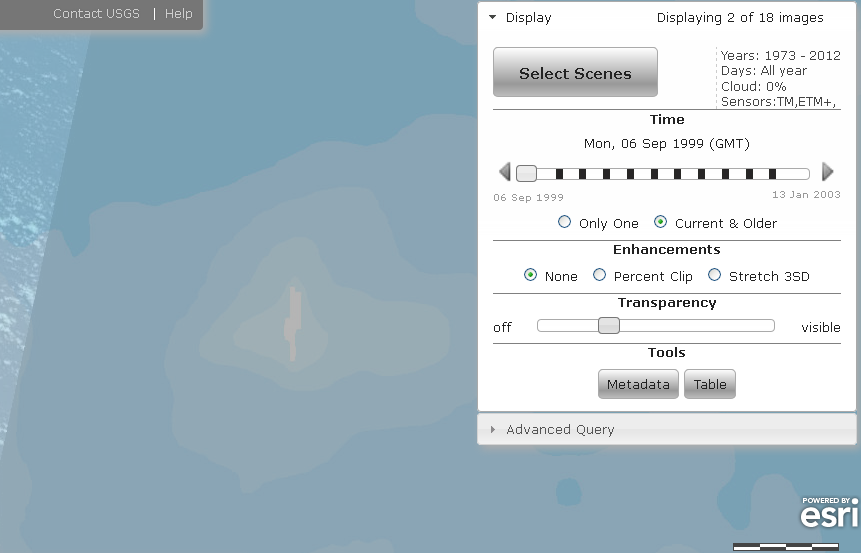
2003 (edited 2012)
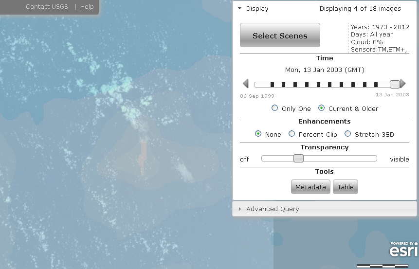
This is their particular imagery dates
landsatlook.usgs.gov...
LE70870741999249EDC00 ETM 1999-09-06 2012-07-04 87 74 87074 2.09 49.34967 52.44243 EDC 1999-09-06T23:20:27Z 6 9 1999 543 249 LE70870731999249EDC00 ETM 1999-09-06 2012-07-04 87 73 87073 3.94 50.39272 53.57421 EDC 1999-09-06T23:20:03Z 6 9 1999 543 249 LE70860741999290EDC00 ETM 1999-10-17 2012-07-04 86 74 86074 5.29 60.81021 72.30191 EDC 1999-10-17T23:14:17Z 17 10 1999 543 290 LE70860742000021EDC01 ETM 2000-01-21 2012-07-04 86 74 86074 0.6 57.5801 95.50011 EDC 2000-01-21T23:14:09Z 21 1 2000 543 21 LE70870742000028EDC00 ETM 2000-01-28 2012-07-04 87 74 87074 6.6 56.9562 92.47894 EDC 2000-01-28T23:20:20Z 28 1 2000 543 28 LE70870732000092EDC00 ETM 2000-04-01 2011-10-27 87 73 87073 9.56 50.12749 56.6643 EDC 2000-04-01T23:19:38Z 1 4 2000 543 92 LE70860742001023EDC00 ETM 2001-01-23 2012-07-04 86 74 86074 5.5 56.76499 94.51106 EDC 2001-01-23T23:11:53Z 23 1 2001 543 23 LE70870742001030EDC00 ETM 2001-01-30 2012-07-04 87 74 87074 8.04 56.15125 91.35835 EDC 2001-01-30T23:18:02Z 30 1 2001 543 30 LE70870732001030EDC00 ETM 2001-01-30 2012-07-04 87 73 87073 10.32 56.31012 93.44936 EDC 2001-01-30T23:17:38Z 30 1 2001 543 30 LE70860732001055EDC00 ETM 2001-02-24 2011-10-27 86 73 86073 3.64 54.38412 79.27455 EDC 2001-02-24T23:11:19Z 24 2 2001 543 55 LE70860742002010EDC00 ETM 2002-01-10 2012-08-17 86 74 86074 0.07 57.61271 99.21269 EDC 2002-01-10T23:10:07Z 10 1 2002 543 10 LE70860732002010EDC00 ETM 2002-01-10 2011-10-27 86 73 86073 0.04 57.57084 101.4319 EDC 2002-01-10T23:09:44Z 10 1 2002 543 10 LE70870742002017EDC00 ETM 2002-01-17 2012-07-04 87 74 87074 3.73 56.93276 97.00918 EDC 2002-01-17T23:16:21Z 17 1 2002 543 17 LE70870732002065EDC00 ETM 2002-03-06 2012-07-04 87 73 87073 6.54 53.07459 73.38898 EDC 2002-03-06T23:16:03Z 6 3 2002 543 65 LE70870742003004EDC00 ETM 2003-01-04 2012-07-04 87 74 87074 3.19 58.17171 100.6951 EDC 2003-01-04T23:15:51Z 4 1 2003 543 4 LE70870732003004EDC00 ETM 2003-01-04 2012-07-04 87 73 87073 3.84 58.09212 102.9603 EDC 2003-01-04T23:15:27Z 4 1 2003 543 4 LE70860742003013EDC00 ETM 2003-01-13 2012-07-04 86 74 86074 4.31 57.25737 98.4224 EDC 2003-01-13T23:09:46Z 13 1 2003 543 13 LE70860732003013EDC00 ETM 2003-01-13 2011-10-27 86 73 86073 3.68 57.23664 100.612 EDC 2003-01-13T23:09:22Z 13 1 2003 543 13
What gets me, image dated 1999, but edited 2012
1999
2003 (edited 2012)
new topics
-
An Apology From the Dunderbeck Sausage Company
Music: 55 minutes ago -
Tucker on Joe Rogan talking Kona Blue and UFOs
Aliens and UFOs: 1 hours ago -
Remember These Attacks When President Trump 2.0 Retribution-Justice Commences.
2024 Elections: 2 hours ago -
Predicting The Future: The Satanic Temple v. Florida
Conspiracies in Religions: 2 hours ago -
WF Killer Patents & Secret Science Vol. 1 | Free Energy & Anti-Gravity Cover-Ups
General Conspiracies: 4 hours ago -
Hurt my hip; should I go see a Doctor
General Chit Chat: 5 hours ago -
Israel attacking Iran again.
Middle East Issues: 6 hours ago -
Michigan school district cancels lesson on gender identity and pronouns after backlash
Education and Media: 6 hours ago -
When an Angel gets his or her wings
Religion, Faith, And Theology: 7 hours ago -
Comparing the theology of Paul and Hebrews
Religion, Faith, And Theology: 8 hours ago
top topics
-
The Democrats Take Control the House - Look what happened while you were sleeping
US Political Madness: 12 hours ago, 18 flags -
In an Historic First, In N Out Burger Permanently Closes a Location
Mainstream News: 14 hours ago, 16 flags -
Biden says little kids flip him the bird all the time.
Politicians & People: 11 hours ago, 9 flags -
Man sets himself on fire outside Donald Trump trial
Mainstream News: 11 hours ago, 9 flags -
Michigan school district cancels lesson on gender identity and pronouns after backlash
Education and Media: 6 hours ago, 7 flags -
WF Killer Patents & Secret Science Vol. 1 | Free Energy & Anti-Gravity Cover-Ups
General Conspiracies: 4 hours ago, 7 flags -
Pentagon acknowledges secret UFO project, the Kona Blue program | Vargas Reports
Aliens and UFOs: 9 hours ago, 6 flags -
Israel attacking Iran again.
Middle East Issues: 6 hours ago, 5 flags -
Remember These Attacks When President Trump 2.0 Retribution-Justice Commences.
2024 Elections: 2 hours ago, 5 flags -
Boston Dynamics say Farewell to Atlas
Science & Technology: 9 hours ago, 4 flags
active topics
-
Man sets himself on fire outside Donald Trump trial
Mainstream News • 44 • : randomuser2034 -
Israel attacking Iran again.
Middle East Issues • 29 • : ToneD -
Are you ready for the return of Jesus Christ? Have you been cleansed by His blood?
Religion, Faith, And Theology • 22 • : glend -
Predicting The Future: The Satanic Temple v. Florida
Conspiracies in Religions • 7 • : randomuser2034 -
Tucker on Joe Rogan talking Kona Blue and UFOs
Aliens and UFOs • 1 • : NoCorruptionAllowed -
An Apology From the Dunderbeck Sausage Company
Music • 0 • : TheMichiganSwampBuck -
Comparing the theology of Paul and Hebrews
Religion, Faith, And Theology • 1 • : glend -
MULTIPLE SKYMASTER MESSAGES GOING OUT
World War Three • 56 • : cherokeetroy -
Hurt my hip; should I go see a Doctor
General Chit Chat • 12 • : tarantulabite1 -
Remember These Attacks When President Trump 2.0 Retribution-Justice Commences.
2024 Elections • 13 • : xuenchen