It looks like you're using an Ad Blocker.
Please white-list or disable AboveTopSecret.com in your ad-blocking tool.
Thank you.
Some features of ATS will be disabled while you continue to use an ad-blocker.

Scientists 'Undiscover' Pacific Island
page: 3share:
reply to post by spacedoubt
i am sure that my girlfriend has something to do with this , she is allways bringing home odd things home after her holidays , pebbles , shells etc so i would not put it past her to have slipped this island in her hand bag .
i am sure that my girlfriend has something to do with this , she is allways bringing home odd things home after her holidays , pebbles , shells etc so i would not put it past her to have slipped this island in her hand bag .
The article at the link was interesting and informative, thank you OP. I followed up with some internet searching on the lead scientist, Dr. Maria
Seton. She's a highly credible PhD with multiple geological publications. I think the explanation in the article is right - this was a cartography
error at some point in the past that was carried forward in the global database. There's really no reason to think otherwise, especially since the
article says this is a normal thing to happen.
Specific quote from the article:
"Mike Prince, the director of charting services for the Australian Hydrographic Service, a department within the Navy that produces the country’s official nautical charts, said the world coastline database incorporated individual reports that were sometimes old or contained errors. "We take anything off that database with a pinch of salt," he said.
However, I can't explain the Google Maps blackout... interesting. Nice find, OP.
Originally posted by winofiend
Either that or...
You have to understand, everything I did, I did for the Island.
o.O

As soon as I read the thread I thought of the Lost island.
We won't be able to find the island, the island has to find us.
THANKS for my Laugh of the day ..
seriously .. I as soon as I read this.. I almost woke up my wife I LOL ~Kudos to the research
seriously .. I as soon as I read this.. I almost woke up my wife I LOL ~Kudos to the research
Originally posted by jude11
reply to post by lavenlaar
I've lost keys, money, girlfriends, bets, and directions.
But never an island.
Strange indeed.
Back in 2009
Google Earth shows it as Sandy Island with no further explanation.
Sandy Island is located at 19 degrees 13' 18.18" S, 159 degrees 56' 13.54" E
I noticed it is blacked out on Yahoo maps and Bing maps as well.
Anyone have any idea what is located here?productforums.google.com...#!topic/earth/V5gNYv_lFjw
And another poster:
I opened the "more" folder in the Layers panel in Google Earth and turned on the digital globe layer archive. There is imagery that has been taken over this island, some from 2009. When you click on the low [ 0-10%] cloud cover tiles, when you look at what should cross with the island shape, all you see is blue water with some clouds floating over. This seems to be the case for the different years. It seems odd.
Possible explanation is "Bad Data"... traced back to 1979.
confirmend with the French Hydrograpic office today, there is a bad area in the elevation model. NW of new Caledonia, SE of Recif Bampton is a phantom Island, Sand Is. This was removed from the navigation charts in 1979. There is no directly measured or gravity derived batymetry to suport this feature. Please disregard this feature.
Peace
edit on 21-11-2012 by jude11 because: (no reason given)
Really odd!
At Bing Maps, the whole area is black.
And Yahoo Maps seems to use the same data as Google:

FlashEarth
At Bing Maps, the whole area is black.
And Yahoo Maps seems to use the same data as Google:
FlashEarth
Here is one, same name, different location....
I think I had a book on this subject, islands that were on charts but did not exist.
Source
I think I had a book on this subject, islands that were on charts but did not exist.
Source
Encyclopedia > Sandy Island
Map of Pitcairn Islands. Source:CIA World Factbook
This article is being considered for deletion in accordance with Wikipedia's deletion policy.
Please share your thoughts on the matter at this article's entry on the Articles for deletion page.
You are welcome to edit this article, but please do not blank this article or remove this notice while the discussion is in progress. For more information, particularly on merging or moving the article during the discussion, read the Guide to deletion.
How to list a page for deletion (log)
Sandy Island is an uninhabited strip of sand in the Oeno Island coral atoll of the South Pacific Ocean. Sandy Island is part of the Pitcairn Islands colony.
Sandy Island is located at 23°54′44″S, 130°43′37″W, about 143 km (77 nautical miles) northwest of Pitcairn Island.
Originally posted by blskv109a
The article at the link was interesting and informative, thank you OP. I followed up with some internet searching on the lead scientist, Dr. Maria Seton. She's a highly credible PhD with multiple geological publications. However, I can't explain the Google Maps blackout... interesting. Nice find, OP.
Obviously, Dr. Seton not real and now no one will look for the island.
Wow!
Phys.org talks about us
phys.org...
Edit:
A Wikipedia page was just created today:
en.wikipedia.org...
Phys.org talks about us
On www.abovetopsecret.com , discussions were robust with one poster claiming he had confirmed with the French hydrographic office that it was indeed a phantom island and was supposed to have been removed from charts in 1979.
Another claimed: "Many mapmakers put in deliberate but unobtrusive and non-obvious 'mistakes' into their maps so that they can know when somebody steals the map data."
phys.org...
Edit:
A Wikipedia page was just created today:
en.wikipedia.org...
edit on 22.11.2012 by grobi77 because: (no reason given)
This sounds like a job for Jack Shephard!!!
Where oh where is Oceanic 815?
I see I'm not the only one thinking along these lines... lol.
Where oh where is Oceanic 815?
I see I'm not the only one thinking along these lines... lol.
edit on 22-11-2012 by SPACEYstranger because: (no reason given)
reply to post by lavenlaar
I almost immediately dismissed this as a case of 'cartographic copyright protection' like Google putting a nonexistent English town on Google Maps, but..
1)
If it was supposed to be a protection, then shouldn't someone have reacted when it showed up on competitor's maps?
2)
Should not Google, Yahoo and Microsoft show either an animated map based on the cartographic data OR just water, if they had become aware of the island not being there? The Blacking-it-out solution makes no sense (to me at least). Also, It is my understanding that blacking out areas are normally only done upon request.
3)
Looking at the topography of the not blacked out surroundings, the nonexistent island is placed just where an island could be expected to be, if one should indeed be there. Look at the pic below - it's composed of screen dumps from Yahoo and Google. Point being that it makes it seem less likely to initially be a random error carried on by other mapmakers.
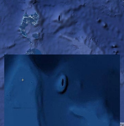
I really would like a comment from Google on why it's blacked out. Strangely neither the interviewer nor the spokesperson address that. Isn't that weird?
Oh well..
I almost immediately dismissed this as a case of 'cartographic copyright protection' like Google putting a nonexistent English town on Google Maps, but..
1)
If it was supposed to be a protection, then shouldn't someone have reacted when it showed up on competitor's maps?
2)
Should not Google, Yahoo and Microsoft show either an animated map based on the cartographic data OR just water, if they had become aware of the island not being there? The Blacking-it-out solution makes no sense (to me at least). Also, It is my understanding that blacking out areas are normally only done upon request.
3)
Looking at the topography of the not blacked out surroundings, the nonexistent island is placed just where an island could be expected to be, if one should indeed be there. Look at the pic below - it's composed of screen dumps from Yahoo and Google. Point being that it makes it seem less likely to initially be a random error carried on by other mapmakers.
I really would like a comment from Google on why it's blacked out. Strangely neither the interviewer nor the spokesperson address that. Isn't that weird?
Oh well..
edit on 22-11-2012 by DupontDeux because: missed a word
:edit on 22-11-2012 by DupontDeux because: missed a letter
too
Considering the thread a couple of years back of "Australia & NZ are out of place of the map" thread.....
Alot of people on there believed australia was a lot further down south & more isolated from any other land masses (instead of virtually touching P.N.G as it is at present) is it worth checking if Sandy Island is still in the place that it would be if Australia was located further south?
Just a random thought....
reply to post by lavenlaar
Probably a lab....scary lab.
The demonstrated on TV many years ago an electrical camo that changes pattern instantly to what is behind it. I bet they have a flawless working type since they showed one that makes an airplane disappear.
Probably a lab....scary lab.
The demonstrated on TV many years ago an electrical camo that changes pattern instantly to what is behind it. I bet they have a flawless working type since they showed one that makes an airplane disappear.
edit on 22-11-2012 by Char-Lee because: (no reason given)
Originally posted by rickymouse
Hmmm....Should have called it turtle island.
Ghost Island because it appears and then disappears!
edit on 22-11-2012 by Skywatcher2011 because: (no reason given)
Has to be Themyscira.
en.wikipedia.org...
en.wikipedia.org...
en.wikipedia.org...
The Amazons had grown tired of the evil ways of mankind in ancient Greece after being enslaved by Hercules and had separated themselves to this island where they could practice a peaceful way of life and cultivate their minds. With the island blessed by the Olympian Gods, no man is allowed to physically set foot on it.
en.wikipedia.org...
The blanking out on Google is interesting.
I'm going to be a convo somewhere along these lines happened
Google employee 1 "Erm hey boss, we just got the new satellite images in, but there's a problem, there's supposed to be an Island here but all I've got is pictures of the Sea"
Boss "Are you sure there's an Island there?"
Google Employee 1 "Yeah I checked, it's on these other maps, even the CIA say it's there"
Boss "Oh God I'm still in trouble for that time we mixed up the Paris and New York data and put the Eiffel Tower in Down town Manhattan, tell you what, just draw a black blob over it, it's not like anyone is going to notice"
OMG!
They found Wonder Woman's Island! They would have seen it if they had taken the invisible jet!
They found Wonder Woman's Island! They would have seen it if they had taken the invisible jet!
new topics
-
The Good News According to Jesus - Episode 1
Religion, Faith, And Theology: 1 hours ago -
HORRIBLE !! Russian Soldier Drinking Own Urine To Survive In Battle
World War Three: 3 hours ago -
Bobiverse
Fantasy & Science Fiction: 6 hours ago -
Florida man's trip overseas ends in shock over $143,000 T-Mobile phone bill
Social Issues and Civil Unrest: 6 hours ago -
Former Labour minister Frank Field dies aged 81
People: 8 hours ago -
SETI chief says US has no evidence for alien technology. 'And we never have'
Aliens and UFOs: 10 hours ago
top topics
-
President BIDEN Vows to Make Americans Pay More Federal Taxes in 2025 - Political Suicide.
2024 Elections: 15 hours ago, 17 flags -
Florida man's trip overseas ends in shock over $143,000 T-Mobile phone bill
Social Issues and Civil Unrest: 6 hours ago, 8 flags -
SETI chief says US has no evidence for alien technology. 'And we never have'
Aliens and UFOs: 10 hours ago, 7 flags -
Former Labour minister Frank Field dies aged 81
People: 8 hours ago, 4 flags -
Ode to Artemis
General Chit Chat: 16 hours ago, 3 flags -
This is our Story
General Entertainment: 13 hours ago, 3 flags -
Bobiverse
Fantasy & Science Fiction: 6 hours ago, 3 flags -
HORRIBLE !! Russian Soldier Drinking Own Urine To Survive In Battle
World War Three: 3 hours ago, 1 flags -
The Good News According to Jesus - Episode 1
Religion, Faith, And Theology: 1 hours ago, 0 flags
active topics
-
HORRIBLE !! Russian Soldier Drinking Own Urine To Survive In Battle
World War Three • 18 • : watchitburn -
Florida man's trip overseas ends in shock over $143,000 T-Mobile phone bill
Social Issues and Civil Unrest • 13 • : Consvoli -
British TV Presenter Refuses To Use Guest's Preferred Pronouns
Education and Media • 137 • : Annee -
Remember These Attacks When President Trump 2.0 Retribution-Justice Commences.
2024 Elections • 54 • : Asher47 -
LaBTop is back at last.
Introductions • 15 • : LaBTopOld -
Russia Ukraine Update Thread - part 3
World War Three • 5727 • : YourFaceAgain -
So this is what Hamas considers 'freedom fighting' ...
War On Terrorism • 259 • : SourGrapes -
Breaking Baltimore, ship brings down bridge, mass casualties
Other Current Events • 479 • : ArMaP -
Lawsuit Seeks to ‘Ban the Jab’ in Florida
Diseases and Pandemics • 31 • : Thefineblackharm -
Tucker Carlson UFOs are piloted by spiritual entities with bases under the ocean and the ground
Aliens and UFOs • 45 • : gippo88