It looks like you're using an Ad Blocker.
Please white-list or disable AboveTopSecret.com in your ad-blocking tool.
Thank you.
Some features of ATS will be disabled while you continue to use an ad-blocker.

A possible 9000 year old map found in Finland.
page: 2share:
Originally posted by TheSparrowSings
Definitely looks like lichen to me. But as far as maps dating back that far, or further, I think it is highly possible. It is even recorded on the Peri Re'is map, from the 1500's, that is was a compilation of many "much older" maps. How old those maps would have to be to show Antarctica without ice is something I do not know. Some people claim Antarctica might have been ice-free as early as 6000 years ago. Some claim it has not been ice-free since at least 34,000,000 years ago.
The fact that the longitude/latitude of many of those ancient maps are correct means that atleast the creators of them knew that the Earth was not flat.
Howdy
The Piri Reis map doesn't show the Antarctic, it shows a distorted and misaligned coast of SA.
Originally posted by Hanslune
Originally posted by TheSparrowSings
Definitely looks like lichen to me. But as far as maps dating back that far, or further, I think it is highly possible. It is even recorded on the Peri Re'is map, from the 1500's, that is was a compilation of many "much older" maps. How old those maps would have to be to show Antarctica without ice is something I do not know. Some people claim Antarctica might have been ice-free as early as 6000 years ago. Some claim it has not been ice-free since at least 34,000,000 years ago.
The fact that the longitude/latitude of many of those ancient maps are correct means that atleast the creators of them knew that the Earth was not flat.
Howdy
The Piri Reis map doesn't show the Antarctic, it shows a distorted and misaligned coast of SA.
If so, why is it totally out of scale while the other half of America is more of 'reality' based? Estimated? Copied from older maps? I do not understand why this part would be so distorted? Ran out of paper and had to bend the rest of the continent to fit?
Originally posted by OnWhiteMars
If so, why is it totally out of scale while the other half of America is more of 'reality' based?
The European and African coast are accurate because they had multiple charts and experience to deal with, the entire American one is a dog's breakfast because they had very little information. If you read the margin notes of the PR it tells you where the source maps are from
If you are interested read Gregory C. McIntosh's The Piri Reis Map of 1513, ISBN 0-8203-2157
Anything from Hapgood or Hancock is fanciful to say the least probably caused by their inability to read the margin notes which tells it story - and their desire to ignore the facts while making up stuff
Estimated? Copied from older maps? I do not understand why this part would be so distorted? Ran out of paper and had to bend the rest of the continent to fit?
It probably came from a undocumented Portuguese exploration, well yes you are right if you look at the real map it does bend to fit to the shape of the animal skin it is written on.
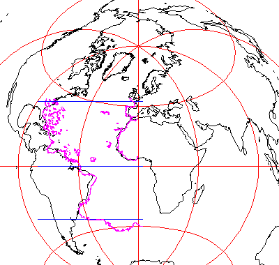
The pink outline is what the PR map shows, the black are the present day outlines
reply to post by Hanslune
I beg to differ my freind.
When placed on a globe the Piri Reis map lines up exactly.
It is meant to sit on a curvature much like our planet.
Our eye does not compensate for the planets three dimensional curvature
on a one dimensional map.
It is quite possible the map OnWhiteMars referenced is a topographical map.
This can also be seen at Nazca.
Is there an 'update' to the findings of this new ancient map..?
"Be safe, be love..be water..my freinds."
edit on 11-2-2013 by HumAnnunaki because: (no reason given)
edit on 11-2-2013 by
HumAnnunaki because: correct spellling errors
new topics
-
University of Texas Instantly Shuts Down Anti Israel Protests
Education and Media: 31 minutes ago -
Any one suspicious of fever promotions events, major investor Goldman Sachs card only.
The Gray Area: 2 hours ago -
God's Righteousness is Greater than Our Wrath
Religion, Faith, And Theology: 7 hours ago -
Electrical tricks for saving money
Education and Media: 10 hours ago -
VP's Secret Service agent brawls with other agents at Andrews
Mainstream News: 11 hours ago
top topics
-
VP's Secret Service agent brawls with other agents at Andrews
Mainstream News: 11 hours ago, 9 flags -
Cats Used as Live Bait to Train Ferocious Pitbulls in Illegal NYC Dogfighting
Social Issues and Civil Unrest: 15 hours ago, 8 flags -
Nearly 70% Of Americans Want Talks To End War In Ukraine
Political Issues: 12 hours ago, 4 flags -
Electrical tricks for saving money
Education and Media: 10 hours ago, 4 flags -
Sunak spinning the sickness figures
Other Current Events: 12 hours ago, 3 flags -
Late Night with the Devil - a really good unusual modern horror film.
Movies: 14 hours ago, 2 flags -
Any one suspicious of fever promotions events, major investor Goldman Sachs card only.
The Gray Area: 2 hours ago, 2 flags -
The Good News According to Jesus - Episode 1
Religion, Faith, And Theology: 17 hours ago, 1 flags -
God's Righteousness is Greater than Our Wrath
Religion, Faith, And Theology: 7 hours ago, 0 flags -
University of Texas Instantly Shuts Down Anti Israel Protests
Education and Media: 31 minutes ago, 0 flags