It looks like you're using an Ad Blocker.
Please white-list or disable AboveTopSecret.com in your ad-blocking tool.
Thank you.
Some features of ATS will be disabled while you continue to use an ad-blocker.

The Perfect Storm
page: 16share:
Reported on the WC..
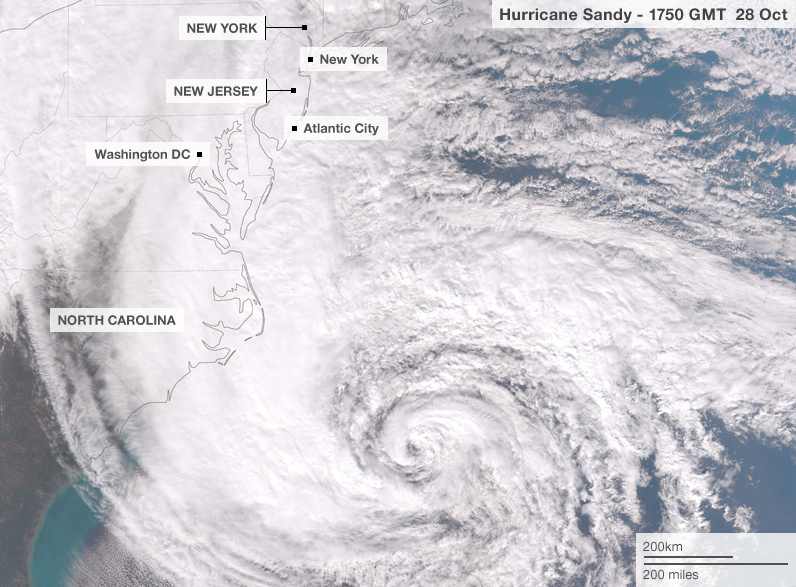
Most of Atlantic City is under water..
Already..
They also showed some video of Cape May where the water is already spilling into the street from the surf..
Most of Atlantic City is under water..
Already..
They also showed some video of Cape May where the water is already spilling into the street from the surf..
Sandy has officially bumped the historic record-holder 1938 hurricane to number TWO in the lowest pressure of a hurricane north of Hatteras.
It is now THE lowest pressure system in recorded history for this area.
It is now THE lowest pressure system in recorded history for this area.
edit on 10-29-2012 by Valhall because: (no reason given)
Route 1 in Delaware is closed. That's the evacuation route from S. Delaware.
Ocean and sand is covering parts of it. It closed last night, but has gotten worse ..
No evacs from S. Delaware or the coast ....
Ocean and sand is covering parts of it. It closed last night, but has gotten worse ..
No evacs from S. Delaware or the coast ....
Originally posted by Valhall
It is now THE lowest pressure system in recorded history for this area
That really low pressure eye is supposed to go right over us at 2 AM.
I'm wondering what low pressure will do to the body ...
Especially my autoimmune ridden body. Maybe nothing. Maybe something.
I guess we'll find out.
Meanwhile, Atlantic City's public safety director says most of the city is under water. Willie Glass says the city is basically flooded and it looks like the damage will be worse than the storm of 1962. Fire officials in Pleasantville report at least two rescues from homes surrounded by water and two more rescues are under way.
abclocal.go.com...
Garden State Parkway is also shut down in two locations down by Atlantic City due to flooding. They warn to expect more of it will also be closed as
the storm approaches.
abclocal.go.com...
abclocal.go.com...
Norfolk is flooding.
United Illuminating is warning its customers that about 35,500 of them will lose power about noon when a power station gets flooded out.
United Illuminating is warning its customers that about 35,500 of them will lose power about noon when a power station gets flooded out.
Another thing to keep an eye on are the inlet bays, when they start receding it is only giving more strenght to what the surge will become at hightide
after nightfall. The ocean literally sucks water energy from the inlets and then builds up for the tidal surge.
reply to post by JacKatMtn
Saw that and the text is pretty scary as it shows sustained wind speeds at much higher rates than expected for a cat one which we have already said is dangerous info for most ppl who have 'ridden out' much larger events.
Saw that and the text is pretty scary as it shows sustained wind speeds at much higher rates than expected for a cat one which we have already said is dangerous info for most ppl who have 'ridden out' much larger events.
reply to post by FlyersFan
I have been in so much pain the past few days, I swear the inside of my bones hurt.
If the power doesn't go out, I am going to sit in a sauna out of desperation.
I have been in so much pain the past few days, I swear the inside of my bones hurt.
If the power doesn't go out, I am going to sit in a sauna out of desperation.
reply to post by Valhall
Just saw that the 3 main power supply chains are reporting upwards of 10k without power now.
Just saw that the 3 main power supply chains are reporting upwards of 10k without power now.
Looks like Tx is under the gun now too. From weather channel feed:
Twitter
TWC_Shawn:
#Hail near Goodnight, TX shatters the windshields of 3 of our #TornadoHunt vehicles.
With the size of this monster storm it is hard to tell how far across the US it is going to move.
So much moisture from the south traveling on the hurricane winds meeting with the northern cold front heading down from Canada.
www.weather.com...
edit on 29-10-2012 by antar because: (no reason given)
Some pictures of local damages.
imgur.com...
Edit to add - They are not my personal pictures.
imgur.com...
Edit to add - They are not my personal pictures.
edit on 29-10-2012 by Doodle19815 because: (no reason given)
reply to post by antar
I'm confused here, those tweets are dated April 30th?
Radar shows no significant weather over TX at the moment.
I'm confused here, those tweets are dated April 30th?
Radar shows no significant weather over TX at the moment.
Best of luck to all those 'riding it out' and thanks for all the constant feedback. I'm in South Africa but keeping a close eye on proceedings there.
Right now we are in the middle of a massive lightning storm. The weather has been crazy here for the last few weeks. Constant rain and storms when we're suppose to be having lovely weather.
I inspect buildings for a living and know that tomorrow I will be running about like crazy.
Posted Via ATS Mobile: m.abovetopsecret.com
Right now we are in the middle of a massive lightning storm. The weather has been crazy here for the last few weeks. Constant rain and storms when we're suppose to be having lovely weather.
I inspect buildings for a living and know that tomorrow I will be running about like crazy.
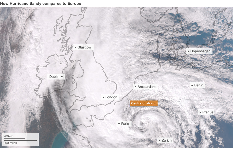
I thought this was an interesting comparison done by BBC News.
From this page:
That is pretty amazing.
From this page:
Hurricane Sandy is huge and its winds could stretch across the eastern third of the US by Monday night, according to the National Hurricane Center. Here's what the storm would look like if its centre were over western Europe:
That is pretty amazing.
I hope that everyone has their insurance paid up because there will be a lot of real estate damaged (if not lost- doesn't look promising for the
islands Chincotigue and Assatigue and the other low lying islands.
new topics
-
How does my computer know
Education and Media: 1 hours ago -
USO 10 miles west of caladesi island, Clearwater beach Florida
Aliens and UFOs: 5 hours ago
top topics
-
Anti-Israel Protesters in CHICAGO Chant 'Death to Israel and 'Death to America'
Social Issues and Civil Unrest: 17 hours ago, 15 flags -
Running Through Idiot Protestors Who Block The Road
Rant: 16 hours ago, 12 flags -
Tesla cutting 14,000 jobs
Global Meltdown: 14 hours ago, 6 flags -
Israel ufo shoot down drones?
Aliens and UFOs: 14 hours ago, 6 flags -
USO 10 miles west of caladesi island, Clearwater beach Florida
Aliens and UFOs: 5 hours ago, 6 flags -
Abortions in first 12 weeks should be legalised in Germany, commission says
Medical Issues & Conspiracies: 14 hours ago, 5 flags -
On this Day in History, April 15, 1865, Abraham Lincoln Passed Away.
General Chit Chat: 14 hours ago, 4 flags -
How does my computer know
Education and Media: 1 hours ago, 0 flags
active topics
-
Abortions in first 12 weeks should be legalised in Germany, commission says
Medical Issues & Conspiracies • 10 • : Freeborn -
President BIDEN Warned IRAN Not to Attack ISRAEL - Iran Responded with a Military Attack on Israel.
World War Three • 38 • : TinfoilTophat -
How does my computer know
Education and Media • 1 • : UpIsNowDown2 -
Canadian Police Urge Citizens To Avoid Conflict With Armed Robbers By Leaving Keys At Front Door
Social Issues and Civil Unrest • 68 • : Astyanax -
Gold and silver prices....woo hoo
History • 71 • : SchrodingersRat -
Afterlife, unknown, so prepare, or just go into the unknown (bad)!!
ATS Skunk Works • 49 • : Kennyb75 -
Fossils in Greece Suggest Human Ancestors Evolved in Europe, Not Africa
Origins and Creationism • 46 • : matafuchs -
America's Infant Mortality Rate Increases for the First Time in 20 Years
Medical Issues & Conspiracies • 17 • : nugget1 -
Mandela Effect - It Happened to Me!
The Gray Area • 98 • : BeTheGoddess2 -
The Truth About Jesus
Conspiracies in Religions • 265 • : glend