It looks like you're using an Ad Blocker.
Please white-list or disable AboveTopSecret.com in your ad-blocking tool.
Thank you.
Some features of ATS will be disabled while you continue to use an ad-blocker.

Another quake in Japan. 4.7
page: 13
share:
Looks like another quake.
earthquake.usgs.gov...
Is this close enough to cause any issues with fukushima?
earthquake.usgs.gov...
Is this close enough to cause any issues with fukushima?
reply to post by JrDavis
4.6 is average for Japan.
As far as the damage to the N. Plants in Fukushima. Difficult to answer unless we get the entire uncensored truth as to their current condition...and that'll never happen.
In other words...No way to tell.
Peace
4.6 is average for Japan.
As far as the damage to the N. Plants in Fukushima. Difficult to answer unless we get the entire uncensored truth as to their current condition...and that'll never happen.
In other words...No way to tell.
Peace
edit on 18-10-2012 by jude11 because: (no reason given)
I'm no expert, but No. I doubt Japanese people even felt it
They're used to having a lot more serious earthquakes.
They're used to having a lot more serious earthquakes.
edit on 18-10-2012 by samsamm9 because: (no reason given)
reply to post by samsamm9
It looks soo close and although I'm in the states it's real sad to have to worry about that kinda stuff. I just went through my first in Maine and with the trouble with the reactor one cannot be to cautious.
What kind of quake would essentially cause harm? Which ones do they look out for?
It looks soo close and although I'm in the states it's real sad to have to worry about that kinda stuff. I just went through my first in Maine and with the trouble with the reactor one cannot be to cautious.
What kind of quake would essentially cause harm? Which ones do they look out for?
Fuku has been taking 4's and 5's since well before the big one. They had a long series of fore-shocks as one might interpret it followed by steady
quakes to this day.
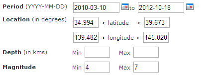
Out of curiosity...I did a quick search at the European Quake data site because it's tools for map searching quake records are so user friendly compared to the USGS. Here is what I found...and the results quite literally startled me. I knew it was constant....I didn't know they had *THIS* many. (I broke this up a bit so the whole page wasn't overwhelming in size to see....they aren't good about condensing data results there)
Here is the criteria I entered:
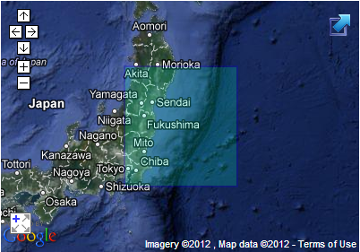
Here is how that translates on the map for where it covers:
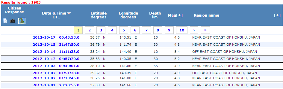
and here is the result.
Data Source
I'd say Fukushima Daiichi as a plant is stable and they've had to make sure of that just to live there at all. 1903 quakes....from the year prior to today's date means they're probably wondering whats up if they DON'T feel a few good shakes in a week period? Of course, I can think of stages of work they could be in where a badly timed quake could be more than annoying. Perhaps, the moments they had the Containment Dome for Unit 3 suspended in the air above the vessel itself. Err..bad time to drop it, indeed. lol...
Out of curiosity...I did a quick search at the European Quake data site because it's tools for map searching quake records are so user friendly compared to the USGS. Here is what I found...and the results quite literally startled me. I knew it was constant....I didn't know they had *THIS* many. (I broke this up a bit so the whole page wasn't overwhelming in size to see....they aren't good about condensing data results there)
Here is the criteria I entered:
Here is how that translates on the map for where it covers:
and here is the result.
Data Source
I'd say Fukushima Daiichi as a plant is stable and they've had to make sure of that just to live there at all. 1903 quakes....from the year prior to today's date means they're probably wondering whats up if they DON'T feel a few good shakes in a week period? Of course, I can think of stages of work they could be in where a badly timed quake could be more than annoying. Perhaps, the moments they had the Containment Dome for Unit 3 suspended in the air above the vessel itself. Err..bad time to drop it, indeed. lol...
reply to post by Wrabbit2000
That is very startling.
I have some questions however, On USGS it shows the fault lines. However, How accurate is this.
Lets say we are polar shifting, Zetatalk likes to say we have stopped rotating but I haven't given that much thought.
However how do we not know if our fault lines are shifting or moving? Are we always going to go by what USGS or other sites state are the fault lines?
What if the top surface of the earth is just shifting. Or spinning over the lower crust of the earth?
I know it's childish to ask that and probably holds no scientific proof but quakes are showing up in spots I've heard never really had them.
Also if they take 4-5.6 within 30 days easily, How is this not causing any form of chaos.
Is it normal for Japan to experience these this often?
edit on 18-10-2012 by JrDavis because: (no reason given)
Originally posted by JrDavis
reply to post by Wrabbit2000
That is very startling.
I have some questions however, On USGS it shows the fault lines. However, How accurate is this.
On fault lines, you're asking the wrong person. Perhaps others have focused on that but I've honestly never bothered to look or care. The reason is simple. In growing up in Southern California, as many quakes seemed to come right in the LA Basin on "Previously unknown" fault lines as came on declared and well recorded ones. That told me enough to distrust the idea that a map fault means more than the fact they FOUND that one. How many others?
Lets say we are polar shifting, Zetatalk likes to say we have stopped rotating but I haven't given that much thought.
However how do we not know if our fault lines are shifting or moving? Are we always going to go by what USGS or other sites state are the fault lines?
I don't think it's childish at all to ask. It was that kind of bug that wouldn't go away that led me to become such a watcher of quake data. An Earthquake in MAINE? That one was a couple days ago. (Source) More quakes in Utah, Colorado, Virginia, Texas, Wisconsin and others...all enough to notice and make reporting something far from silly. Some like Virginia, scared the stuffing out of people. So indeed.. what IS going on? It's a good question. None of those places are unheard of..and in fact, one of the bigger quakes in North American history was outside Charleston, South Carolina of all places. (Source) A healthy 7.3. I know we're talking about Fuku, not America, but in a true sense, this is activity happening across the world and Fuku just had the HORRIBLE misfortune of being where it triggered a Tsunami with a bad bad Nuke Plant design.
Also if they take 4-5.6 within 30 days easily, How is this not causing any form of chaos.
Is it normal for Japan to experience these this often?edit on 18-10-2012 by JrDavis because: (no reason given)
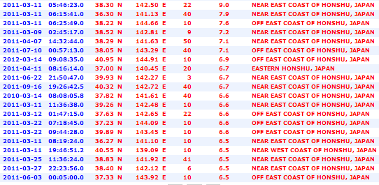
I figure a picture is worth a thousand words, in this case. Same site as above. Just a different search criteria. The box covers the West shore as well as the East, but that didn't matter. It all still showed off the Fuku coast and the same small area the Tsunami quake came from, for the most part.
You seem really interested in all this so let me throw one more resource your way that should prove useful. I wish I could link my own sites just occasionally..but I can't so the data source I build my own quake areas on websites from will have to do. Do you check the Heliplots often? I swear I can ALMOST tell now what general area a quake happened in just by looking at a half dozen or so plots around the world and figuring quickly who was closer and when by the displays. Not QUITE that accurate..but hey, we all get our diversions where we can right?
Advanced National Seismic System (ANSS)
and it's global companion network
Global Seismic Network (GSN)
(One quick word on the plot displays... SOME will show wild wild readings. I mean it looks like God drop kicked the planet for a field goal and scored.....ignore them unless you see more than one looking the same in very different places. Some stations get wacky from time to time and Antarctica is purely amusement. THAT place is downright twilight zone ALL the time on seismic measurements)
reply to post by Wrabbit2000
the susceptibility to earth quakes has been magnified by the discovery that the reactor building has sank 31.5 inches and could sink further. on the other hand this quake is several hundred miles from Fukushima so it shouldn't be any problem.
the susceptibility to earth quakes has been magnified by the discovery that the reactor building has sank 31.5 inches and could sink further. on the other hand this quake is several hundred miles from Fukushima so it shouldn't be any problem.
reply to post by LittleBlackEagle
Do you by chance have a link on the actual figure given for the damage at Unit 4 with it's sinking issue?
I do have this to add, and about half way down the Fuku Status Report is a photograph dated 03 Sept, 2012 which shows extensive fortification and support work done to one side of Unit 4. The photo is the completed concrete work. I'd noticed by the threads on the topic that the reports indicating this problem date prior to the completion photo for work being done to address it.
Fukushima Daiichi Current Condition Report 10 September, 2012
Hopefully, the work they did will have solved the issue. At least for now.
edit on 18-10-2012 by Wrabbit2000 because: (no reason
given)
reply to post by Wrabbit2000
I think work needs to be pushed further. I mean honestly I'm in no position to tell Japan what I think they should do LOL although they are really technology driven (At least in the average Americans eye), If they are saying it will take decades to be able to have that technology to clean it up, Then that is a really scary thing to think. Since I admire their technology so much. It's almost unreal to hear them say that.
But I guess my concern isn't for the other countries that will be effected by radiation. It's for the Japanese citizens too! They are living right next to it, And that must be something that makes it hard to go to sleep at night.
I am really interested in quakes now (Yeah I am 13 miles away from Hollis Center, The Maine Epicenter).
However I also think it's Earth speaking to us.
Maybe it has indigestion? LOL
I just want it all to pass safely for everyone that deserves no wrong doing in this crazy world today.
But last year seemed to be very busy for Japan in March. Kinda odd to say I'm glad it's not as bad as last year... Yet.
I'm not wishing to belittle the OP, but seriously. Earthquakes happen every day here and I wish some of you would stop obsessing over it every time
you see one on a feed somewhere.
I felt it here in Tokyo. The effect in Tokyo was stronger than expected for such a relatively light quake. I know saying a 4.7 as light way come as a
surprise, but you have to remember what we have experienced here in Japan. A 4.7 is really close to danger level for former Fukushima NPP. Reactor
four is a total mess and I am sure it cannot handle anything over a 5.5 at least.
new topics
-
2024 Pigeon Forge Rod Run - On the Strip (Video made for you)
Automotive Discussion: 48 minutes ago -
Gaza Terrorists Attack US Humanitarian Pier During Construction
Middle East Issues: 1 hours ago -
The functionality of boldening and italics is clunky and no post char limit warning?
ATS Freshman's Forum: 2 hours ago -
Meadows, Giuliani Among 11 Indicted in Arizona in Latest 2020 Election Subversion Case
Mainstream News: 2 hours ago -
Massachusetts Drag Queen Leads Young Kids in Free Palestine Chant
Social Issues and Civil Unrest: 3 hours ago -
Weinstein's conviction overturned
Mainstream News: 4 hours ago -
Supreme Court Oral Arguments 4.25.2024 - Are PRESIDENTS IMMUNE From Later Being Prosecuted.
Above Politics: 5 hours ago -
Krystalnacht on today's most elite Universities?
Social Issues and Civil Unrest: 6 hours ago -
Chris Christie Wishes Death Upon Trump and Ramaswamy
Politicians & People: 6 hours ago -
University of Texas Instantly Shuts Down Anti Israel Protests
Education and Media: 8 hours ago
top topics
-
Krystalnacht on today's most elite Universities?
Social Issues and Civil Unrest: 6 hours ago, 8 flags -
Weinstein's conviction overturned
Mainstream News: 4 hours ago, 6 flags -
University of Texas Instantly Shuts Down Anti Israel Protests
Education and Media: 8 hours ago, 5 flags -
Supreme Court Oral Arguments 4.25.2024 - Are PRESIDENTS IMMUNE From Later Being Prosecuted.
Above Politics: 5 hours ago, 5 flags -
Massachusetts Drag Queen Leads Young Kids in Free Palestine Chant
Social Issues and Civil Unrest: 3 hours ago, 4 flags -
Meadows, Giuliani Among 11 Indicted in Arizona in Latest 2020 Election Subversion Case
Mainstream News: 2 hours ago, 4 flags -
Any one suspicious of fever promotions events, major investor Goldman Sachs card only.
The Gray Area: 10 hours ago, 2 flags -
Chris Christie Wishes Death Upon Trump and Ramaswamy
Politicians & People: 6 hours ago, 2 flags -
Gaza Terrorists Attack US Humanitarian Pier During Construction
Middle East Issues: 1 hours ago, 2 flags -
God's Righteousness is Greater than Our Wrath
Religion, Faith, And Theology: 15 hours ago, 1 flags
active topics
-
Supreme Court Oral Arguments 4.25.2024 - Are PRESIDENTS IMMUNE From Later Being Prosecuted.
Above Politics • 59 • : xuenchen -
University of Texas Instantly Shuts Down Anti Israel Protests
Education and Media • 181 • : cherokeetroy -
Candidate TRUMP Now Has Crazy Judge JUAN MERCHAN After Him - The Stormy Daniels Hush-Money Case.
Political Conspiracies • 777 • : Oldcarpy2 -
Breaking Baltimore, ship brings down bridge, mass casualties
Other Current Events • 489 • : Threadbarer -
-@TH3WH17ERABB17- -Q- ---TIME TO SHOW THE WORLD--- -Part- --44--
Dissecting Disinformation • 679 • : McTech2 -
Gaza Terrorists Attack US Humanitarian Pier During Construction
Middle East Issues • 15 • : Irishhaf -
Massachusetts Drag Queen Leads Young Kids in Free Palestine Chant
Social Issues and Civil Unrest • 9 • : theatreboy -
Meadows, Giuliani Among 11 Indicted in Arizona in Latest 2020 Election Subversion Case
Mainstream News • 5 • : Disgusted123 -
God's Righteousness is Greater than Our Wrath
Religion, Faith, And Theology • 29 • : Topcraft -
2024 Pigeon Forge Rod Run - On the Strip (Video made for you)
Automotive Discussion • 4 • : TheInvisibleRedneck
3