It looks like you're using an Ad Blocker.
Please white-list or disable AboveTopSecret.com in your ad-blocking tool.
Thank you.
Some features of ATS will be disabled while you continue to use an ad-blocker.

Tremors felt 45 miles away from Bayou Corne Sinkhole!
page: 96share:
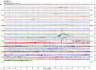
The seismic calm over the past week at the sinkhole is over. Notice the large fluid movement at 6:09 this morning, sinkhole time.
this image and others
It shows up on most of the local seismos. Activity (obvious fluid movement signatures) looks to have started back up yesterday, a little after 3 pm local time.
Bummer, I thought maybe things were settling out under the sinkhole.
ETA: The police jury blog is reporting a burp yesterday afternoon--caught on video. Wonder what this mornings fluid movement looked like?
this image and others
It shows up on most of the local seismos. Activity (obvious fluid movement signatures) looks to have started back up yesterday, a little after 3 pm local time.
Bummer, I thought maybe things were settling out under the sinkhole.
edit on 8/9/2013 by Olivine because: (no reason given)
ETA: The police jury blog is reporting a burp yesterday afternoon--caught on video. Wonder what this mornings fluid movement looked like?
edit on 8/9/2013 by Olivine because: (no reason given)
edit on 8/9/2013 by Olivine because: (no reason
given)
Can you say a little more about a fluid movement so that we can understand what it is please?
Is is like the ripples on a lake or throwing a stone into a pond, the ripples gradually die out and we can see this in the height of the peaks as the peaks reduce? That would probably mean there was a 'pond' down there.
...Or does it mean that a tremor has hit a body of fluid down in the earth like water in a swimming pool and the wave is moving back and forth off the 'sides' of the swimming pool?
What is the fluid? Probably water, gas under pressure or oil? Can we estimate how large the body of fluid is from the weight and width of the wave on the graph? Can we estimate the distance from the sensor(s) by these too?
reply to post by qmantoo
We have been told that the fluid is gas (mostly methane) and a small amount of other hydrocarbons, which is evidenced by the sheen on the sinkhole surface after a "burb".
The latest CB&I report from July 16th states that the authorities believe the DRZ (disturbed rock zone) extends down to about 8000'. They don't know exactly at what depth the gas is located; there are several possible locations noted on page 12 of the above pdf.
I understand the "fluid movement" signatures on the helicorders to represent gas escaping from somewhere in the DRZ . That's why we see the long period waves, but not "regular" earthquake signatures--because the rock is already broken. So I guess I would visualize the signatures as "pockets" of gas knocking back and forth along a rock pathway--similar to the clanging water hammer makes in a pipe not dampened properly.
The gas is under pressure because of the depths, and is connected to the Oxy3 cavern via the sidewall breach. Each time there is a "burp" event, the pressure readings in the cavern fluctuate.
Well, that is what I understand to be happening.
OK, thats great. Thanks.
So I guess I would visualize the signatures as "pockets" of gas knocking back and forth along a rock pathway--similar to the clanging water hammer makes in a pipe not dampened properly.
The gas is under pressure because of the depths, and is connected to the Oxy3 cavern via the sidewall breach. Each time there is a "burp" event, the pressure readings in the cavern fluctuate.
This would appear to be suggesting that the gas is causing a hammer-like effect on the Disturbed Rock Zone and possibly is going to cause more destruction in the area surrounding the gas pockets, further weakening the caverns and salt dome.
TB and other oil and gas companies probably know at what depth these gas pockets are located because they have drilled through them on their way down, but we are assuming that they are coming from pockets to the west of the DRZ and not from underneath? Is that right?
It would be interesting to know the true depth of the sinkhole now, since we had that depth measurement which ran out of line and they did not think it was worth adding more line to the depth guage. We have to speculate that the sinkhole is getting deeper and so where does it go from here? Just creeping down the line of the DRZ I suppose and just how deep it is going to extend is anyone's guess.
LA15 has been off (apart from a day in the middle) since the afternoon of 01 Aug 13. Must be pretty serious to be down for that time. It is obviously not electronics or modems this time since they had that day in the middle when it was working OK.
No news about the latest 3D report yet and it is almost halfway through August.
edit on 12 Aug 2013 by qmantoo because: LA15
So this blurb from the 13th of August on the Assumption Parish blog gave me pause.
I'm thinking "the containment berms can't still subsiding".
But then I watched the 2 most recent flyover videos. Doesn't the south berm look low...and wet? They have been hauling limestone and clay onto the south and east berms for weeks, according to the updates. Check it out.
Just wanted to add: the surface looks awfully oily considering how quiet the seismos have been the past few days.
Stockpiling clay for containment
I'm thinking "the containment berms can't still subsiding".
But then I watched the 2 most recent flyover videos. Doesn't the south berm look low...and wet? They have been hauling limestone and clay onto the south and east berms for weeks, according to the updates. Check it out.
Just wanted to add: the surface looks awfully oily considering how quiet the seismos have been the past few days.
edit on 8/14/2013 by Olivine because: add a thought
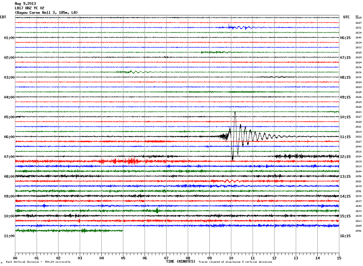
It looks like the microquakes have returned to the sinkhole. This image is from LA17, 185 meters deep.
If you go back to early on the 17th, you can see one small quake at 06:49 UTC on many of the stations (found here), then mostly quiet, and then they pick up the pace in the most recent 12 hours. Check out station LA12 (near SW corner of containment berm):
LA14 (south of Cavern 3):
If you go back to early on the 17th, you can see one small quake at 06:49 UTC on many of the stations (found here), then mostly quiet, and then they pick up the pace in the most recent 12 hours. Check out station LA12 (near SW corner of containment berm):
LA14 (south of Cavern 3):
3:25 p.m. Burp Occurring in Sinkhole
There has been another burp that occurred and is continuing on the sinkhole. All operations have been pulled from inside of the sinkhole until activity calms down. The monitoring/alert status has been heightened to Code 3.
Below is a definition of the codes:
Code Levels are 1-3, with Code 1 being the lowest level of alert.
Code 1: Minimal to no seismic activity around/below sinkhole; 10 or fewer of the sharp seismic signals associated with rock movement, called mini-earthquakes (MEQs) or the longer signals associated with gas or liquid movement, called Very Long Periods (VLPs) within 24-hour period; allows work on sinkhole and inside berm area to continue
Code 2: Restricts work directly on the sinkhole, indicates some increased seismic activity around/below sinkhole but not at a level that indicates imminent threat of sloughing or movement below sinkhole (10 to 50 MEQs or VLPs in 24 hours)
Code 3: Restricts all work inside the containment berm, indicates seismic activity has elevated to a point similar to what has been seen in past monitoring prior to a sloughing on the shore or movement beneath sinkhole (More than 50 MEQs or VLPs in 24 hours)
Source
reply to post by Anmarie96
Thanks for the update Anmarie.
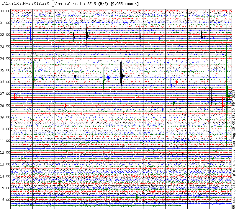
Check out the helicorders right now. CERI temp array
Big fluid movement signatures. This can't be good.
This is LA1702, found at the link above.
Here is a video of a huge slough in caught earlier this evening...WOW!
Thanks for the update Anmarie.
Check out the helicorders right now. CERI temp array
Big fluid movement signatures. This can't be good.
This is LA1702, found at the link above.
Here is a video of a huge slough in caught earlier this evening...WOW!
edit on 8/21/2013 by Olivine because: (no reason given)
reply to post by Olivine
Thanks for the update - read the article on another site - thinking of all of you down there, stay safe - saving my place in the thread.
Thanks for the update - read the article on another site - thinking of all of you down there, stay safe - saving my place in the thread.
reply to post by Olivine
Olivine, hey:
Question for you.....sorry, can't watch the video, just looking at the pic. Is that a burp./slough or a tidal surge? have you checked the tides and times? Just wondering, as I truly wonder if the salt layer has been eroded enough far enough underwater that what we may be seeing is an open channel to the GOM, now.
Just wondering about your thoughts on this?
Sincerely,
Tetra50
reply to post by Olivine
"The monitoring/alert status has been heightened to Code 3. "
i do believe thnks in great part too your efforts,,in providing real time accurate analysis of the wavey line stuff.
nice work.
"The monitoring/alert status has been heightened to Code 3. "
i do believe thnks in great part too your efforts,,in providing real time accurate analysis of the wavey line stuff.
nice work.
reply to post by Olivine
That's some awesome footage right there! You can see is perk before land let's loose... If I were filming that, I would have been like oh sh..! and glad it let loose in front of me instead of where I was standing - which face it could have happened :-/ ... They need web cams about so folks aren't risking their life to get a video!!!
That's some awesome footage right there! You can see is perk before land let's loose... If I were filming that, I would have been like oh sh..! and glad it let loose in front of me instead of where I was standing - which face it could have happened :-/ ... They need web cams about so folks aren't risking their life to get a video!!!
reply to post by Olivine
WOW!
That is amazing video. Kudos to the videographers for remaining so calm. But the "perk" and the sudden movement--the escalation and then the calming--my totally untrained eye says tidal flow. Like the tide (in the Gulf) was high. Maybe a way to match the times.
Anyways, I'll go back to my "lurking" ways here. I am still stunned that major US Media still ignores this story and it's implications for LA and GOM.
Stay safe...and hopefully some one can set up REMOTE cameras so that lives don't have to be risked going out & filming.
hi guys, beggar's request here ... please.
would someone post some stills from the video that some of us can't watch, purty please ?
@Tetra50 ... maybe but hopefully not just yet.
although, strangely enough, i awoke this morn in tears for some reason i cannot pinpoint.
(no, i'm not depressed)
2 nights ago, while staring at a map and discussing this disaster with my mate, my eyes focused on both Morgan City and Thibodaux (not familiar with either region), and it gave me chills so badly that i had to turn off the AC and grab a blanket.
perhaps what you suggest is relative to what i sensed ?
lordy i hope not but as i've said many times, this disaster is far from over.
@ anyone with the ability ... pics/stills please ?
i offer a special thank you to whomever made the video but please folks, move far away from the loch-nar. (Heavy Metal reference for those who don't recognize 'lochnar')
edit on 21-8-2013 by Honor93 because: typos
reply to post by Honor93
My thought, Honor, reading your last post, is just with Katrina, most of us here cannot afford to go anywhere.....
More's the pity, and I hope we don't see the same all over, in a different frame of reference, as in on the ground as opposed to from the sky.....
Tetra50
I hope and pray for safety for all of us, daily.
reply to post by Honor93
I live in Thibodaux .
In the last 24 hours the seismographs have been off the charts and continues till now. I don't think we have seen the last of this.
Also, that video was taken by John Boudreaux, Parish Homeland security director,
I live in Thibodaux .
In the last 24 hours the seismographs have been off the charts and continues till now. I don't think we have seen the last of this.
Also, that video was taken by John Boudreaux, Parish Homeland security director,
edit on 22-8-2013 by CajunBoy because: (no reason
given)
Amazing that they were able to get that on video. Right time, right place. This is not done growing. I can't believe how quickly it sucked in those
trees. BTW- morning all!
I can't help with pic/stills. Wish I had the knowledge. Let's hope your 'feeling' about Thibodaux is incorrect I think that is were CB is located. We need him & his safe and sound. I will mapquest Morgan City to see where that is.
Originally posted by Honor93
2 nights ago, while staring at a map and discussing this disaster with my mate, my eyes focused on both Morgan City and Thibodaux (not familiar with either region), and it gave me chills so badly that i had to turn off the AC and grab a blanket.
@ anyone with the ability ... pics/stills please ?
i offer a special thank you to whomever made the video but please folks, move far away from the loch-nar. (Heavy Metal reference for those who don't recognize 'lochnar')edit on 21-8-2013 by Honor93 because: typos
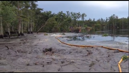
Hey Honor93, here is a sequence of stills from the video, taken at 27, 32, 37, and 42 seconds in.
In the 1st frame, the central section of tall trees has already begun sinking a few feet, almost straight down.
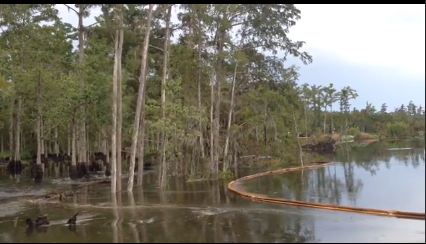
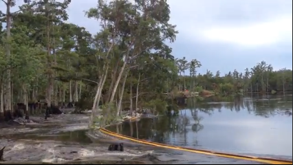
By this 3rd frame, you can see how agitated the waters have become, and only the tree tops are left.
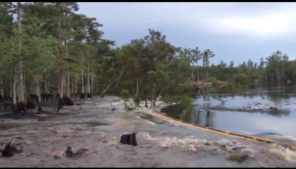
...and now they are gone to the depths.
Someone asked about webcams. According to the 1st page of the latest (August 20) GOHSEP situation summary, Texas Brine installed cameras watching the Oxy#3 well pad and the sinkhole on January 29th. I have never been able to find public access to those cameras.
In the 1st frame, the central section of tall trees has already begun sinking a few feet, almost straight down.
By this 3rd frame, you can see how agitated the waters have become, and only the tree tops are left.
...and now they are gone to the depths.
Someone asked about webcams. According to the 1st page of the latest (August 20) GOHSEP situation summary, Texas Brine installed cameras watching the Oxy#3 well pad and the sinkhole on January 29th. I have never been able to find public access to those cameras.
I made an updated visual aid of the seismograph locations. The
map given on the police jury site has a few
items mislabeled, such as LA13-->they removed that surface equipment and replaced it with 2 borehole seismos, LA17 01 & 02.
Additionally, it doesn't show the sinkhole.
I borrowed the base image from Governor's Office of Homeland Security & Emergency Preparedness, found here. It shows the sinkhole, but is not the most recent imagery.
This map is looking toward the south, and seismos 15 & 16 are not shown--they are off to the left side of the image.
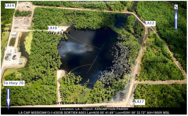
Here is the link to the helicorders. CERI (the top 4 are in Arkansas, the remainder are at the sinkhole)
Additionally, it doesn't show the sinkhole.
I borrowed the base image from Governor's Office of Homeland Security & Emergency Preparedness, found here. It shows the sinkhole, but is not the most recent imagery.
This map is looking toward the south, and seismos 15 & 16 are not shown--they are off to the left side of the image.
Here is the link to the helicorders. CERI (the top 4 are in Arkansas, the remainder are at the sinkhole)
new topics
-
USO 10 miles west of caladesi island, Clearwater beach Florida
Aliens and UFOs: 3 hours ago
top topics
-
Anti-Israel Protesters in CHICAGO Chant 'Death to Israel and 'Death to America'
Social Issues and Civil Unrest: 15 hours ago, 15 flags -
Denver to Defund the Police 8.4 Million To Pay for Illegal Aliens
Social Issues and Civil Unrest: 17 hours ago, 14 flags -
Running Through Idiot Protestors Who Block The Road
Rant: 13 hours ago, 12 flags -
Fossils in Greece Suggest Human Ancestors Evolved in Europe, Not Africa
Origins and Creationism: 17 hours ago, 9 flags -
Report March 2024 - Underwater UFOs display capability that ‘jeopardizes US maritime security,’
Aliens and UFOs: 17 hours ago, 6 flags -
Tesla cutting 14,000 jobs
Global Meltdown: 12 hours ago, 6 flags -
USO 10 miles west of caladesi island, Clearwater beach Florida
Aliens and UFOs: 3 hours ago, 6 flags -
Israel ufo shoot down drones?
Aliens and UFOs: 12 hours ago, 5 flags -
Abortions in first 12 weeks should be legalised in Germany, commission says
Medical Issues & Conspiracies: 12 hours ago, 5 flags -
On this Day in History, April 15, 1865, Abraham Lincoln Passed Away.
General Chit Chat: 12 hours ago, 4 flags
active topics
-
Mandela Effect - It Happened to Me!
The Gray Area • 97 • : inflaymes69 -
Abortions in first 12 weeks should be legalised in Germany, commission says
Medical Issues & Conspiracies • 9 • : Vermilion -
Running Through Idiot Protestors Who Block The Road
Rant • 45 • : glen200376 -
The Reality of the Laser
Military Projects • 27 • : Zaphod58 -
Israel ufo shoot down drones?
Aliens and UFOs • 17 • : Zaphod58 -
Tesla cutting 14,000 jobs
Global Meltdown • 43 • : Vermilion -
USO 10 miles west of caladesi island, Clearwater beach Florida
Aliens and UFOs • 6 • : matafuchs -
-@TH3WH17ERABB17- -Q- ---TIME TO SHOW THE WORLD--- -Part- --44--
Dissecting Disinformation • 471 • : 777Vader -
Woke Leftist dems, hate Your Rights and the Country;
Political Issues • 62 • : ashisnotanidiot -
It has begun... Iran begins attack on Israel, launches tons of drones towards the country
World War Three • 625 • : Justoneman