It looks like you're using an Ad Blocker.
Please white-list or disable AboveTopSecret.com in your ad-blocking tool.
Thank you.
Some features of ATS will be disabled while you continue to use an ad-blocker.

Tremors felt 45 miles away from Bayou Corne Sinkhole!
page: 91share:
Another small burp:
More debris released by sinkhole
Moderate seismic activity had been notes by several watching the seismos over the weekend and posting about it in the Bayou Corne sinkhole Facebook page.
Personnel monitoring the Bayou Corne sinkhole in Assumption Parish detected a small disturbance, or burp, Saturday afternoon that released debris and hydrocarbons in the center of the 22-acre sinkhole.
After researcher Stephen Horton noticed increased activity in the sinkhole about 1:30 p.m., he alerted officials the incident had taken place, said John Boudreaux, director of the Assumption Parish Homeland Security and Office of Emergency Preparedness.
Boudreaux said there are several air-monitoring sites in the vicinity and the readings after the afternoon event indicated that hydrocarbons in the atmosphere were well below harmful levels.
Boudreaux said burps occur when hydrocarbons located deep in the earth work their way upward and escape through the sinkhole into the atmosphere.
More debris released by sinkhole
Moderate seismic activity had been notes by several watching the seismos over the weekend and posting about it in the Bayou Corne sinkhole Facebook page.
I go to this site daily to see what is going on with the sinkhole.
lasinkhole.wordpress.com...
From the most recent report sound like the officials don't want to share info but then we already knew that they were selective in what they release.
lasinkhole.wordpress.com...
From the most recent report sound like the officials don't want to share info but then we already knew that they were selective in what they release.
Gone down some more looks like.
Assumption Parish
July 9, 2013 11:25 a.m. Update Texas Brine has reported that the floor of Oxy 3 Cavern has gone down another 150′ to 4,088′ in measured depth. We will keep everyone posted as information becomes available.
Assumption Parish
Originally posted by lurksoften
Gone down some more looks like.
July 9, 2013 11:25 a.m. Update Texas Brine has reported that the floor of Oxy 3 Cavern has gone down another 150′ to 4,088′ in measured depth. We will keep everyone posted as information becomes available.
Assumption Parish
When are these officials going to make a statement regarding this? I hate these burps by Texas Brine because it leaves out the 5 W's, who, what, when, where & WHY!!!! Where is it going? Why is it dropping & not rising? What could be the consequences of? I thought they had geologists and scientists on this situation, someone needs to demand an answer or two.
I think it is interesting that I just watched a video where Sonny from TB is stating that things are stabilizing... must have been a real old clip.
BTW- Sinkhole was mentioned on/in:
Huffington Post- Louisiana Sinkhole Forcing Longtime Neighbors Away From Area
Wunderground.com- 22-Acre Sinkhole Evacuates Entire Community
Plus a few other places... let's hope the word spreads and people are made aware of what is truly going on in the Bayou.
Yesterday there was some activity on LA10 which looks suspisciously like drilling or some other kind of work there. It started at around 7-ish and
ended around 4:40-ish. Apart from that the graphs are very clean.
Almost too clean. For the week, there are a couple of spikes on Saturday, but I cannot really believe that everything has stopped around LA10, although if the cavern has filled up (and is now sinking again) it must mean that most of the falling debris has stopped and there is no room left for any further collapses.
Maybe they have recalibrated to not show us the smaller wobblies? There is no way we can find out - or is there? It says at the bottom left "Each vertical division is 20,000 microvolts" Going back to June it was also 20,000 so I guess either there is no recalibration or else the recording devices themselves have been recalibrated and the graphs are still using the original units. They only seem to keep a months data at the links below. I cannot go back further than that.
LA10 9th July 00:00-12:00
LA10 9th July 12:00-24:00
LA16 has been off since Saturday. No graphs.
A few spikes on LA17 on Sunday but the other recorders appear pretty clear.
Update from Assumption Parish Operational Situation
Summary
Next
Operational Period (09 - 12 July 2013)
Incident Action Plan
Not sure what they mean by next call?
- Continuing pressure monitoring operations at 1465 Sauce Piquante. Next pressure monitoring location is planned for 116 Crawfish Stew Street
next week
- Placed 475 Lf of clay on the South Berm on Tuesday (7/2)
-Placed 650 LF of clay on the west berm extension on Tuesday and Wednesday (7/2-3)
- Completed density tests on the east and west berms on Tuesday and Wednesday (7/2-3); All passing.
- Placed riprap at intersection of North Berm and TBC access road (west side) and on the north side of pad 3 on Wednesday (7/3)
- Constructed pad to bubble site located on Maurice Road, west of flare 5 on Wednesday (7/3)
- Installed three settlement plates on south berm on Wednesday (7/3)
- Conducted Barton meter maintenance @ ORWs 12, 15, 36, 40 and OGRW-1; flaring
- Changed out orifice plates in ORW 40 on Tuesday (7/2)
- Entergy provided temporary power on Rig Road and Maurice Road and Flares 3 and 5 were switched from generator power to electrical power
- Installed transducers at GOW-5-4 on Tuesday (7/2)
- Pumped ORW 38 on Wednesday (7/3)
- Re-developed ROI monitoring well ROI-9-5 on Monday (7/8)
- Began collecting ROI test pressure data for GOW-5-2, GOW-5-3, GOW-9-3 and GOW-9-4 on yesterday (Monday 7/8)
- Completed CPT 34 (east end of Sauce Piquante) on Wednesday (7/3)
- Replaced cone which was previously damaged during advancing CPT 39 W on Tuesday (7/2) of last week; A replacement boring CPT 39WR
(located on Sauce Piquante) was completed on Monday (7/8)
- Completed CPT 40 (located on Sauce Piquante) on Monday (7/8)
- Installed packers in GOW-5-2, GOW-9-3 and GOW-9-4 on Tuesday (7/2)
- Installed transducers in GOW-5-2, GOW-5-3, GOW-9-3 and GOW-9-4 and GOW-9-5 on Tuesday (7/2)
- Tagged bottom of OG3A on 7/5, TD of 4088’ (hard bottom)
• There were ~12 VLP events yesterday with ~3 VLP events detected since midnight. A number of large
VLP events have been observed on LA12 this morning. Seismic level is at Code 2 (7/9)
Next
Operational Period (09 - 12 July 2013)
Incident Action Plan
Not sure what they mean by next call?
• Scientific Group:
• Will hold its next call on 10 July
Well not sure if this is old news but it was attached to a recent update by
Texas Brine Company dated 7/8/2013. I saw this document
going through Sinkhole Bugle. Did anyone else know they stop Air Monitoring back in March? Sorry if its
been posted already first i saw it.
Texas Brine Update Letter
Residential Air Monitoring Sage has been requested to suspend bimonthly residential air monitoring. Therefore, Sage will discontinue these activities. The last event was conducted on March 26, 2013.
Texas Brine Update Letter
Scientific group probably has a conference call meeting every so often, so that they dont all have to be there physically. There are quite a few
different organisations represented if I remember correctly.
Recent stuff - More on fracking and earthquakes and some geothermal causing earthquakes too
Distant seismic activity can trigger quakes at 'fracking' sites 11Jul13
Study: Distant quakes can affect oil, gas fields 11Jul13
Geothermal Power Facility Induces Earthquakes, Study Finds 11Jul13
Distant seismic activity can trigger quakes at 'fracking' sites 11Jul13
Powerful earthquakes thousands of miles (km) away can trigger swarms of minor quakes near wastewater-injection wells like those used in oil and gas recovery, scientists reported on Thursday, sometimes followed months later by quakes big enough to destroy buildings.
The discovery, published in the journal Science by one of the world's leading seismology labs, threatens to make hydraulic fracturing, or "fracking," which involves injecting fluid deep underground, even more controversial.
Study: Distant quakes can affect oil, gas fields 11Jul13
LOS ANGELES (AP) — The powerful earthquake that rocked Japan in 2011 set off tremors around a West Texas oil field, according to new research that suggests oil and gas drilling operations may make fault zones sensitive to shock waves from distant big quakes.
It's long been known that large quakes can trigger minor jolts thousands of miles from the epicenter. Volcanically active spots like Yellowstone National Park often experience shaking after a large distant event.
Less is known about the influence of remote quakes on fault lines that have been weakened by man-made activity like the deep disposal of wastewater at the Texas oil field. A new study led by researchers at Columbia University and published Friday in the journal Science suggests a strong quake that strikes halfway around the globe can set off small to mid-size quakes near injection wells in the U.S. heartland.
Geothermal Power Facility Induces Earthquakes, Study Finds 11Jul13
An analysis of earthquakes in the area around the Salton Sea Geothermal Field in southern California has found a strong correlation between seismic activity and operations for production of geothermal power, which involve pumping water into and out of an underground reservoir.
Hello fellow Bayou Corne sinkhole monitors.
I found a few interesting tidbits this evening.
First, looking at the daily inspection report from today, Texas Brine began preparations to P&A (Plug and Abandon) ORW #12 and TBC #s 1 & 2.
According to this outdated map of relief well locations, ORW #12 is at the failed Oxy-Geismar#3 cavern pad, and if I remember correctly, so are TBC's 1 & 2 (the pipe that was in the water in a photo a few months back).
My guess is that Texas Brine feels the stability and future access to these are in jeopardy, and it is better to try to seal them now--but that is just a guess.
Looking again at the report and map above, nearby ORW #14, just south of the cavern #3 pad is flaring strongly, with a 7/64" choke and 46 psig tubing pressure.
What is it flaring you ask? Mostly Methane---92.98%, 2.18% Ethane, and less than 1% Propane and Iso-Butane.
This gas data can be found in the Daily Reports/Letter to the Commissioner date 07/12/2013, along with data on other relief well gas compositons from May 21-24 sampling.
Notice that they have a column for Tritium (radioactive isotope of hydrogen), but none of the samples contained any.
Let's see...I don't think the Assumption Parish Operational Summary from Friday 07/12/2013 has been posted yet, so here it is. (scroll thru to read the updates in red)
You can also access Texas Brine's spin on the seismic situation (dated 9 May 2013) at their page here.
I found it interesting that they have hired an engineering firm to study the stability of their brine production wells and caverns "with special emphasis" on cavern #1.
Do you think they have concerns about the salt dome, even after their repeated assurances that the 3D seismic survey and vertical seismic surveys 'show' that the dome is intact and has not moved?
I do.
edit on 7/15/2013 by Olivine because: trying to fix my wall o' text
Wow!
I'm still reading thru the PDF file from last night's community briefing, but it sounds like the Louisianna DNR has serious issues with Texas Brine's interpretation of the 3D seismic data.
They are reprocessing & doing their own interpretation from the raw data, which TB did not want to share because of "confidentiality" concerns.
You can also find a link to the video from last night's meeting on the Policy Jury Blog
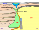
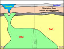
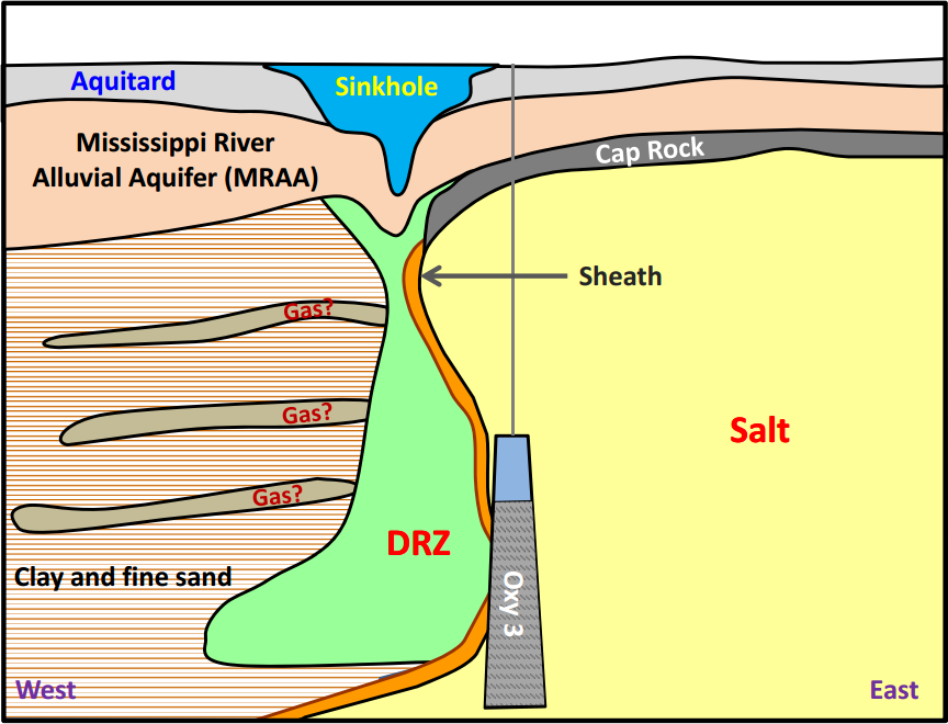
These 2 illustrations are updated, showing what is now believed to be the extent of the DRZ (disturbed rock zone). They can be found on pages 19 & 20 of the pdf linked above.
(click for moar bigger picture )
I'm still reading thru the PDF file from last night's community briefing, but it sounds like the Louisianna DNR has serious issues with Texas Brine's interpretation of the 3D seismic data.
They are reprocessing & doing their own interpretation from the raw data, which TB did not want to share because of "confidentiality" concerns.
You can also find a link to the video from last night's meeting on the Policy Jury Blog
These 2 illustrations are updated, showing what is now believed to be the extent of the DRZ (disturbed rock zone). They can be found on pages 19 & 20 of the pdf linked above.

(click for moar bigger picture )
edit on 7/17/2013 by Olivine because: add illustrations
edit on 7/17/2013 by Olivine
because: fix broken link
reply to post by qmantoo
It is funny we made that observation long ago. Good job ATS.
On the resident homefront, they are getting angry. They are not being treated well by TB at all. TB is dragging butt when it comes to buyouts. Not only they are dragging butt but they are really not making much attempt to get deals with ones who did not make a deal with them yet.
Also, it comes to my attention that the weekly paycheck of I believe $850 from TB for being evacuated, well TB just notified the residents that that is all Taxable income on the residents.
A group of residents are taking the press clubs and picking up an advocate here and there. The battle may have started, but the war is yet to end in Bayou Corne.
I also have a two pictures here of strange life coming out of the ditches in large numbers after rain. They are worms but never in these large numbers
have they appeared.


Any idea what species is this and if they feed off say methane or some other gas.


Any idea what species is this and if they feed off say methane or some other gas.
What confidentiality would be breached by the disclosure of this I wonder? Maybe it shows the collapse of different areas not just the area around Oxy#3 and THAT would be a concern for far more people and open them up to a MUCH bigger compensation claim. You wait, they will file for bankrupcy or do some serious company name shifting. What are the directors doing with their shares? Follow the money and the money will tell the whole story.
it sounds like the Louisianna DNR has serious issues with Texas Brine's interpretation of the 3D seismic data.
They are reprocessing & doing their own interpretation from the raw data, which TB did not want to share because of "confidentiality" concerns.
I think that we seriously need to get our hands on that 3D seizmic report. How did they get the raw data from TB I wonder? It will be at least 3 months before we get any notice of anything serious in that report and by that time, there will be other issues. I wonder if we can get Erin Brockovich to get the report from them?
In that PDF I notice that they have not shown any details for subsidence towards Oxy #1 to the East. To the west, they have shown all the complete
contours, not so to the East. On page 25, it shows the "Burp" but over to the left there is a far more interesting dip and spike in the graph when
the water level rose to nearly 13 feet. I guess that was the heavy rains which we speculated at the time might have disolved some of the salt.
What is interesting is, not so much the burp which is bringing stuff to the surface, but the possible disintergration or not of the salt in the salt dome. I feel they are doing the old magicians trick by getting us to look hard at the 'burp' and failing to show us the other bits which may be far more dangerous.
If there is a meeting soon, maybe someone could ask where the majority of the minor tremours are happening, and whether the earthquake positional data is going to be made available so that we can find out where the quakes are moving to.
reply to post by qmantoo
Do you think Dr. Horton at University of Memphis is not allowed to give his analysis of the epicenter locations? Or maybe they just can't be more precise than "in the general area of the sinkhole"--we are talking about distances less than a few hundred feet.
Most earthquakes listed on USGS have location error estimates listed in kilometers, so maybe more precision isn't possible?
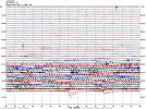
Wherever the VLP waves are originating from, they are happening fairly continuously, at the moment. This is representative of gas/fluid movement. I expect news of another burp or subsidence event soon.
This is from LA17 (shallow 185meters down) (this station is the one furthest North and West):
source
Do you think Dr. Horton at University of Memphis is not allowed to give his analysis of the epicenter locations? Or maybe they just can't be more precise than "in the general area of the sinkhole"--we are talking about distances less than a few hundred feet.
Most earthquakes listed on USGS have location error estimates listed in kilometers, so maybe more precision isn't possible?
Wherever the VLP waves are originating from, they are happening fairly continuously, at the moment. This is representative of gas/fluid movement. I expect news of another burp or subsidence event soon.
This is from LA17 (shallow 185meters down) (this station is the one furthest North and West):
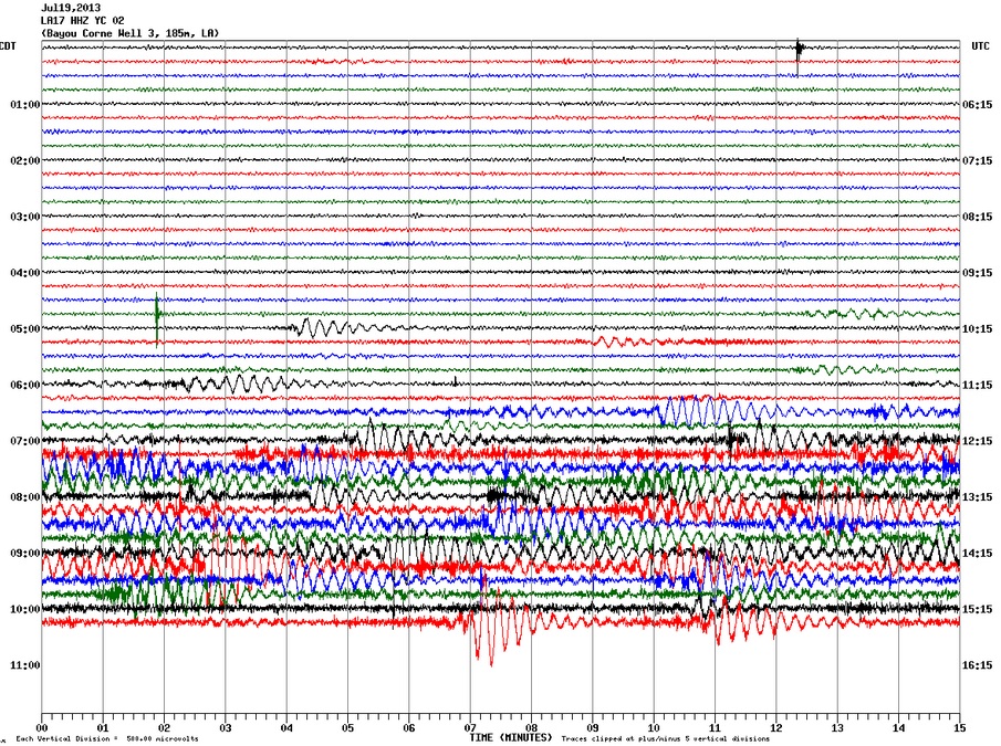
source
Lots of a activity today
[Quote] Officials: ‘Burp event’ underway at giant Louisiana sinkhole — “Lots of activity” — “Abundant surface water movement”
There is lots of activity on the sinkhole this morning. Dr Horton reports that this increase in activity started about 5:00 a.m. (this morning).
There is abundant surface water movement [...]
Also, currently, a burp event is occurring in the center of the sink hole. [...]
Source< br />
www.youtube.com...
reply to post by Anmarie96
That video is so strange; it's like tides going in and back out, without the waves.
Thanks for linking it.
That video is so strange; it's like tides going in and back out, without the waves.
Thanks for linking it.
reply to post by Olivine
That's a lot of fluid movement, no wonder we are seeing those long period waves on the seismos.
I wonder what causes it to oscillate like that? Water/hydrocarbons from below bubbling up and displacing the surface water which then rushes back into the void?
I will say also the the area of DRZ seems to be MUCH larger than originally thought, my concern that this would also indicate much more void spaces below into which future collapses could fall.
edit on 19-7-2013 by jadedANDcynical because: Typos
but the USGS depth is measued in tenths of a kilometre which is either unscientific or else they are able to accurately measure depths by triangulation in 3d space. I cannot imagine scientists using guestimates in this depth measurements so they probably only publish tenths of a Km when in actual fact they can probably resolve it to a few hundredths with a larger margin for error.
Most earthquakes listed on USGS have location error estimates listed in kilometers, so maybe more precision isn't possible?
IF this is what they do, then I would expect a positional measurement to within 100m or so.You have to remember the size of the Napoleonville Salt Dome is (from memory) 3x2 miles large. Also, it probably depends what speed the processor is running within the seizmic measuring devices as to how accurately the incoming wave can be measured. I know nothing about this by the way - as you can probably tell. :-)
USGS is not involved with these measurements by the way. At least, that is what someone told me in an email from USGS when I was looking for the raw data.
Yes, I can imagine this is what would cause it. Large bubbles rising to the surface of a liquid. That in itself is very disturbing since this is probably methane and it means that the hole to the methane store is large - creating large bubbles rather than a stream of smaller ones.
I wonder what causes it to oscillate like that? Water/hydrocarbons from below bubbling up and displacing the surface water which then rushes back into the void?
I hope this stops but I think now that a conduit to the methane store has been created, it will not be able to be stopped. Who knows how much and how many millions of cu feet of methane in in that deposit? It must pose a fire/explosion hazzard in that area too.
edit on 19 Jul 2013 by qmantoo
because: methane
new topics
-
Weinstein's conviction overturned
Mainstream News: 1 hours ago -
Supreme Court Oral Arguments 4.25.2024 - Are PRESIDENTS IMMUNE From Later Being Prosecuted.
Above Politics: 2 hours ago -
Krystalnacht on today's most elite Universities?
Social Issues and Civil Unrest: 2 hours ago -
Chris Christie Wishes Death Upon Trump and Ramaswamy
Politicians & People: 3 hours ago -
University of Texas Instantly Shuts Down Anti Israel Protests
Education and Media: 5 hours ago -
Any one suspicious of fever promotions events, major investor Goldman Sachs card only.
The Gray Area: 7 hours ago
top topics
-
VP's Secret Service agent brawls with other agents at Andrews
Mainstream News: 16 hours ago, 11 flags -
Krystalnacht on today's most elite Universities?
Social Issues and Civil Unrest: 2 hours ago, 7 flags -
Nearly 70% Of Americans Want Talks To End War In Ukraine
Political Issues: 17 hours ago, 6 flags -
Sunak spinning the sickness figures
Other Current Events: 17 hours ago, 5 flags -
Electrical tricks for saving money
Education and Media: 15 hours ago, 5 flags -
Supreme Court Oral Arguments 4.25.2024 - Are PRESIDENTS IMMUNE From Later Being Prosecuted.
Above Politics: 2 hours ago, 5 flags -
Weinstein's conviction overturned
Mainstream News: 1 hours ago, 4 flags -
University of Texas Instantly Shuts Down Anti Israel Protests
Education and Media: 5 hours ago, 3 flags -
Any one suspicious of fever promotions events, major investor Goldman Sachs card only.
The Gray Area: 7 hours ago, 2 flags -
Chris Christie Wishes Death Upon Trump and Ramaswamy
Politicians & People: 3 hours ago, 1 flags
active topics
-
Supreme Court Oral Arguments 4.25.2024 - Are PRESIDENTS IMMUNE From Later Being Prosecuted.
Above Politics • 39 • : xuenchen -
Chris Christie Wishes Death Upon Trump and Ramaswamy
Politicians & People • 13 • : mysterioustranger -
"We're All Hamas" Heard at Columbia University Protests
Social Issues and Civil Unrest • 283 • : FlyersFan -
Weinstein's conviction overturned
Mainstream News • 11 • : 5thHead -
University of Texas Instantly Shuts Down Anti Israel Protests
Education and Media • 105 • : cherokeetroy -
Candidate TRUMP Now Has Crazy Judge JUAN MERCHAN After Him - The Stormy Daniels Hush-Money Case.
Political Conspiracies • 747 • : Justoneman -
Nearly 70% Of Americans Want Talks To End War In Ukraine
Political Issues • 81 • : FlyersFan -
Biden--My Uncle Was Eaten By Cannibals
US Political Madness • 73 • : CarlLaFong -
-@TH3WH17ERABB17- -Q- ---TIME TO SHOW THE WORLD--- -Part- --44--
Dissecting Disinformation • 671 • : daskakik -
VP's Secret Service agent brawls with other agents at Andrews
Mainstream News • 46 • : CarlLaFong