It looks like you're using an Ad Blocker.
Please white-list or disable AboveTopSecret.com in your ad-blocking tool.
Thank you.
Some features of ATS will be disabled while you continue to use an ad-blocker.

Tremors felt 45 miles away from Bayou Corne Sinkhole!
page: 83share:
I don't think the sinkhole is done. It may have burped but things have not settled down. Usually the seismos get quiet after a burp, but not today. CERI Memphis is still showing tremors occurring. Maybe we will see another burp or maybe a cave in.
Originally posted by CajunBoy
reply to post by AuntB
unreported
New bubble site within 100' of a Bayou Corne residence
Not a good sign at all.
Edited to add:
It's a new rainbeaudais video, but it won't play here for some reason.
Not a good sign at all.
Edited to add:
It's a new rainbeaudais video, but it won't play here for some reason.
edit on 7-5-2013 by jadedANDcynical because: It's a new
rainbeau
There is not late night construction or explosives going off and I sure no one is going up and kicking the meters, but LA 11, 12, and 14 helicorders
are picking up after dark activities. They seem to be big jolts. Thoughts?
Just a re-post to the link of helicorders at the Bayou Corne sinkhole site:
folkworm.ceri.memphis.edu...
Just a re-post to the link of helicorders at the Bayou Corne sinkhole site:
folkworm.ceri.memphis.edu...
edit on 7-5-2013 by CajunBoy because: (no reason given)
As someone who knows nothing about Helicorders, I still think this is unusual and I think we "might have a problem Houston"
LA14 has gone beserk and one whole like shows large spikes. Can someone check it out please?
Looking at the other graphs, there seems to be a fair few spikes at the surface and smaller ones deeper underground. Also I noticed other graphs which echo LA14, so I think we might have a cave-in going on.
================================
I have created a web page which shows in real-time, the graphs on the helicorder page. Every visit or refresh of the page will read the graphs for today and show them as thumbnails. I got so fed up with clicking on each link to see the graphs that I created them all on one page. Hope it is useful for people who do not have the super-duper earthquake software.
Link here - Check out LA14 and LA10-01
Morning All! We have photos.
Lake FUBAR is Bubbling Furiously I do wonder what is going on. Has the methane release intensified? We know that the seismographs have not settled down. So what will happen? Guesses anyone?
If you click the photos link on the link I linked.... (way to many links in that sentence), one can scroll down to a flyover video. Here is the video: At 1:04 as they are moving towards the sinkhole look at the trees. Do we have trees that are dying outside of the immediate sinkhole perimeter? It looks like two areas of trees that are losing the battle.
edit on 8-5-2013 by AuntB because: add video
reply to post by qmantoo
I think we need to take these maps you displayed and look at the newest flyover, look at the trees, ask our boots on the ground (Cajunboy) and
see if there is tree die off in other areas of the salt dome. It does look like trees that are not in full leaf which is a sign of stress, which in
turn could be methane.
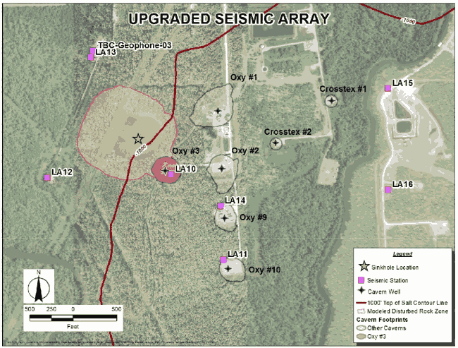
I was looking for maps of where the seizmos are and I could not find one (I may have missed it) so I thought I would post another to remind us where
the areas of activity are. It seems to be LA11, LA12 & LA14 which are going wild at the moment, so we can see from this pic/map that they are not that
near to Oxy 3.
I know it is ridiculous, but any site with 'wordpress' in the URL is blocked for me by the Great Firewall - as is Youtube, Twitter, and all the rest of the social media sites. Oh well...
I know it is ridiculous, but any site with 'wordpress' in the URL is blocked for me by the Great Firewall - as is Youtube, Twitter, and all the rest of the social media sites. Oh well...
edit on 8 May 2013 by qmantoo because: (no reason given)
Look at what I found on ATS very own Quake Watch. Makes me feel good that Olivine is watching over the sinkhole.
Olivine's Post
If this doesn't link directly to Olivine's post, her post is about 5 posts from the bottom of the page.
Olivine's Post
If this doesn't link directly to Olivine's post, her post is about 5 posts from the bottom of the page.
edit on 8-5-2013 by AuntB because: (no
reason given)
edit on 8-5-2013 by AuntB because: fixing link
A new update from
Celestial Convergence and
On Wings Of Care
today...
From Celestial Convergence
From On Wings Of Care. With new flyover video on the page.
From Celestial Convergence
Latest Flyover Of The Bayou Corne Sinkhole Reveals Mysterious And "Unusual Foam-Like Bubbles"!
The pool of liquid did not seem too much larger than it appeared to us a month ago (April 2), but the dead and dying trees to the west were more evident.
Appreciable amounts of rainbow sheen still cover the north and northeastern parts of the pool.
Today the lighting on some ripples near center of the sinkhole gave an unusual foam-like appearance.
From On Wings Of Care. With new flyover video on the page.
20130506- Bayou Corne Flyover #7
2013 May 06 Monday
Bayou Corne, Louisiana
The recent rains have brought much water to the surrounding swampland. The tremendous amount of drilling in the area is more evident now than before, or perhaps we have just learned to recognize it! We flew in a counter-clockwise direction today. The community to the northwest of the sinkhole looked quite deserted.
More photos and a video are provided at the bottom of this article.
edit on 8-5-2013 by happykat39 because: typo
I have a friend who's family owns a good portion of land adjacent to the sinkhole property. TB has been building on his family's land without
permission. This land has been in his family possession before Louisiana statehood which I found very interesting to learn something like that.
Though I know the actions this family is taking, I am not at liberty to say exactly what actions they are taking. I'll just say that I don't think the insurance company will be able to cover TB's butt on this one.
Though I know the actions this family is taking, I am not at liberty to say exactly what actions they are taking. I'll just say that I don't think the insurance company will be able to cover TB's butt on this one.
Bubbles!!! No one is talking about these. Is it not really bubbles but sheen on the water? or is it a butt load of methane bubbling up? Any theories? On another site someone suggested it could be Corexit. What do you think? Is it possible that the oil dispersant that they used in the Gulf has made its way to the sinkhole and maybe beyond.
Latest Flyover Of The Bayou Corne Sinkhole Reveals Mysterious And "Unusual Foam-Like Bubbles"!
Or am I thinking to much about them?
We would (or they would, and I doubt they will do that in case we find out) have to have it analysed to find out if it is methane or something much
nastier floating to the top of the sinkhole.
I believe it has been hypothesised that that ships have gone down sunk in the ocean because of a load of methane bubbles came up from the deep all around them, something about making the water displacement different and so the ships no longer float. (not sure if this is right or not). I would be very careful if anyone wants to go out there in a boat to investigate 'cos they could go the same way - straight to the bottom.
They are doing a regular analysis of the material and chemical in the sinkhole though I think. I will see if there is anything online about that. However, they would probably say 'hydrocarbons' which can hide a multitude of other stuff.
I keep on saying this, but surely someone who lives in the area MUST know someone who works for the authorities who can give us the latest info on the situation that they get. The folks who work for the authorities probably live close by too, so they are in the same boat as the rest of the population.
Originally posted by AuntB
Bubbles!!! No one is talking about these. Is it not really bubbles but sheen on the water? or is it a butt load of methane bubbling up? Any theories? On another site someone suggested it could be Corexit. What do you think? Is it possible that the oil dispersant that they used in the Gulf has made its way to the sinkhole and maybe beyond.
Latest Flyover Of The Bayou Corne Sinkhole Reveals Mysterious And "Unusual Foam-Like Bubbles"!
Or am I thinking to much about them?
Corexit is not a simple dispersant. It contains some detergent like components. It was a month or two back that someone made a connection between methane, oil and corexit from the gulf and the bubbling as far inland as Lake Peigneur. So it is very possible that the increases being seen in all of them are related to gulf seepage through the strata of the bedrock and the salt domes.
The corexit spread over the gulf was not aerated by rising gas, however, if the methane from the gulf is rising through the corexit laced water of the sinkhole that could be enough aeration to cause foaming.
Originally posted by qmantoo
We would (or they would, and I doubt they will do that in case we find out) have to have it analysed to find out if it is methane or something much nastier floating to the top of the sinkhole.
Hydrogen Sulfide, a poisonous, as well as explosive, gas has also been found in the bubbling gas as well as in the gas from the relief wells. That is about as much "nastier" as I would like to see
I believe it has been hypothesised that that ships have gone down sunk in the ocean because of a load of methane bubbles came up from the deep all around them, something about making the water displacement different and so the ships no longer float. (not sure if this is right or not). I would be very careful if anyone wants to go out there in a boat to investigate 'cos they could go the same way - straight to the bottom.
It is now believed that methane releases are the cause of the disappearances in the Bermuda Triangle and other places where mysterious disappearances have taken place. A large enough bubble could allow a boat to drop below water level and be swamped completely by the inrush of water as the "hole" left by the bubble fills back in. The methane bubble could also be responsible for aircraft disappearing there as well. Not only would the lighter methane not provide as much lift as normal air; it would also starve the engine of oxygen and cause a sudden and complete loss of power. That would let the aircraft drop below water level and be swamped just like a ship would.
They are doing a regular analysis of the material and chemical in the sinkhole though I think. I will see if there is anything online about that. However, they would probably say 'hydrocarbons' which can hide a multitude of other stuff.
It has been announced more than once that the material testing is being done. The problem is that no one has released the results yet. CajunBoy had an inside source but later events led him to believe that he couldn't rely on him either. Our president said that "The only people who hide things are people who have something to hide". How ironic that statement turned out to be. Yet it applies to so much we are not being told about the sinkhole that it is frightening.
I keep on saying this, but surely someone who lives in the area MUST know someone who works for the authorities who can give us the latest info on the situation that they get. The folks who work for the authorities probably live close by too, so they are in the same boat as the rest of the population.
See my previous statement on the subject. We can't trust anyone in authority to give honest answers even when they do give them.
edit on 9-5-2013 by happykat39 because: (no reason given)
Originally posted by qmantoo
I believe it has been hypothesised that that ships have gone down sunk in the ocean because of a load of methane bubbles came up from the deep all around them, something about making the water displacement different and so the ships no longer float. (not sure if this is right or not). I would be very careful if anyone wants to go out there in a boat to investigate 'cos they could go the same way - straight to the bottom.
I believe it to be possible, but I'm not sure there would be enough bubbling to have the necessary effect.
“One proposed sinking mechanism attributes the vessel’s loss of buoyancy to bubbles of methane gas released from an erupting underwater hydrate,” they wrote. “The known abundance of gas hydrates in the North Sea, coupled with the vessel’s final resting position and its location in the Witches Hole, all support a gas bubble theory.”
No one has ever seen such an eruption, and no one knows how large the bubbles coming off a methane deposit would be.
Could methane bubbles sink ships?
From what I understand, any kind of bubbling coming from water makes a ship, or boat lose buoyancy(sp), and will make it sink. I know that doesn't
make sense, but....It's kinda like, if you are swimming in salt water that has a really high salt content, you can not drown. I seen it somewhere. I
guess the high salt content makes you more buoyant? Don't quote me on that.
At the bottom of the helicorder plots, - example here it states
that the spikes are clipped to 5 vertical sections, so how do we estimate how large the spike would really go?
I am assuming that this tells us how large the tremor is and what magnitude it is (although I realise that many of these are small, they are still significant if they cause the salt dome to collapse) Perhaps it is the horizontal length of shake, signifying rumbling which we should be concentrating on?
I am assuming that this tells us how large the tremor is and what magnitude it is (although I realise that many of these are small, they are still significant if they cause the salt dome to collapse) Perhaps it is the horizontal length of shake, signifying rumbling which we should be concentrating on?
Double
edit on 10-5-2013 by CajunBoy because: (no reason given)
Hell of a lot of rain down here last night. There was 5 breaches in the berm last night.
reply to post by qmantoo
Here is a link to a plot of the same station for today (Universal Time) without the traces clipped.
You can reach any of the sinkhole helicorders from the IRIS Quackquery page.
Choose the 'Explore Data' link---then under the 'Network' column, scroll to the bottom and choose 'YC'.
Next, choose whichever 'Station' you would like to view (LA12, for example).
The 'Location' column is for a few of the stations that are down boreholes, such as LA10 and LA17, where one seismo maybe 900' deep, and the other is only 400'.
Finally, choose a 'Channel'. They will either be offered as: EH1, EH2, & EHZ, or HH1, HH2, & HHZ. The 'Z' channels show vertical movement; those are ones you want.
The other two show horizontal movement, which can be north-south & east-west, or NE-SW & NW-SE, for example. You have to look at the channel's Metadata to figure that out--each station is different.
Once you have made all of the above choices, choose the day you want to view (today is day 130).
Now finally, under the last column on the right, 'Display Data', click the 'Webicorder of Selected Time Series Data' link in blue.
Your plot, unclipped, should load in a new window.
edit on 5/10/2013 by Olivine because: format cluster
new topics
-
Ditching physical money
History: 2 hours ago -
One Flame Throwing Robot Dog for Christmas Please!
Weaponry: 2 hours ago -
Don't take advantage of people just because it seems easy it will backfire
Rant: 2 hours ago -
VirginOfGrand says hello
Introductions: 3 hours ago -
Should Biden Replace Harris With AOC On the 2024 Democrat Ticket?
2024 Elections: 4 hours ago -
University student disciplined after saying veganism is wrong and gender fluidity is stupid
Education and Media: 6 hours ago -
Geddy Lee in Conversation with Alex Lifeson - My Effin’ Life
People: 7 hours ago -
God lived as a Devil Dog.
Short Stories: 8 hours ago -
Police clash with St George’s Day protesters at central London rally
Social Issues and Civil Unrest: 9 hours ago -
TLDR post about ATS and why I love it and hope we all stay together somewhere
General Chit Chat: 10 hours ago
top topics
-
Hate makes for strange bedfellows
US Political Madness: 12 hours ago, 20 flags -
Who guards the guards
US Political Madness: 15 hours ago, 13 flags -
University student disciplined after saying veganism is wrong and gender fluidity is stupid
Education and Media: 6 hours ago, 12 flags -
Police clash with St George’s Day protesters at central London rally
Social Issues and Civil Unrest: 9 hours ago, 9 flags -
TLDR post about ATS and why I love it and hope we all stay together somewhere
General Chit Chat: 10 hours ago, 7 flags -
Should Biden Replace Harris With AOC On the 2024 Democrat Ticket?
2024 Elections: 4 hours ago, 5 flags -
Has Tesla manipulated data logs to cover up auto pilot crash?
Automotive Discussion: 17 hours ago, 3 flags -
One Flame Throwing Robot Dog for Christmas Please!
Weaponry: 2 hours ago, 3 flags -
God lived as a Devil Dog.
Short Stories: 8 hours ago, 3 flags -
Don't take advantage of people just because it seems easy it will backfire
Rant: 2 hours ago, 3 flags
active topics
-
Should Biden Replace Harris With AOC On the 2024 Democrat Ticket?
2024 Elections • 38 • : Lumenari -
One Flame Throwing Robot Dog for Christmas Please!
Weaponry • 5 • : nugget1 -
Hate makes for strange bedfellows
US Political Madness • 37 • : YourFaceAgain -
Candidate TRUMP Now Has Crazy Judge JUAN MERCHAN After Him - The Stormy Daniels Hush-Money Case.
Political Conspiracies • 742 • : Annee -
Ditching physical money
History • 11 • : BernnieJGato -
1980s Arcade
General Chit Chat • 24 • : 5thHead -
Don't take advantage of people just because it seems easy it will backfire
Rant • 4 • : VirginOfGrand -
The Superstition of Full Moons Filling Hospitals Turns Out To Be True!
Medical Issues & Conspiracies • 21 • : VirginOfGrand -
-@TH3WH17ERABB17- -Q- ---TIME TO SHOW THE WORLD--- -Part- --44--
Dissecting Disinformation • 633 • : Justoneman -
VirginOfGrand says hello
Introductions • 1 • : VirginOfGrand