It looks like you're using an Ad Blocker.
Please white-list or disable AboveTopSecret.com in your ad-blocking tool.
Thank you.
Some features of ATS will be disabled while you continue to use an ad-blocker.

Tremors felt 45 miles away from Bayou Corne Sinkhole!
page: 81share:
I saw those magic windows in Switzerland only a month or so ago. They were proper wall hanging pictures and were really quite beautiful (and expensive
too).
Ladies and gentlemen, the sinkhole will be grabbing some national attention on the History Channel's Swamp People. Pierre Part (5 miles down the
road) resident and SP star Troy Landy will be leading the way.
There is a new update at the Celestial
Convergence, but since the only source cited at CC is
The Advocate I am going to just use it as the
sole source.
4/23/2013 flyover
BY DAVID J. MITCHELL
River Parishes bureau
April 28, 2013
Texas Brine Co. is building a westward extension of a 1.5-mile containment berm encircling the Assumption Parish sinkhole because a 200-foot stretch of the earthen wall is sinking, authorities said Friday.
John Boudreaux, director of the parish Office of Homeland Security and Emergency Preparedness, said Texas Brine contractors began work on the berm expansion Friday. The V-shaped “reroute” is shown on a company map jutting out from the western part of the berm.
Before the latest developments, Texas Brine officials had said the berm, which is being designed to last at least 20 years, is due for completion by July 1.
Conservation officials have said the berm was designed to hold the sinkhole even at the worst-case size predicted by scientists, about 1,400 feet in diameter. The sinkhole now measures about 1,000 feet across.
Sonny Cranch, spokesman for Texas Brine, said Friday that because of the subsidence, the company is playing it safe and building the new berm.
In addition to the sinkhole, the shift in earth left behind a zone of fractured rock running up outside the cavern and alongside the Napoleonville Dome, scientists have said.
Hecox said that sands from the Mississippi River Alluvial Aquifer, which runs in a band about 120 feet to as much as 600 feet deep, are flowing down into the zone of broken rock under the sinkhole.
Also, the sinkhole’s volume has more than doubled since it was calculated in October, rising from 550,000 cubic yards to 1.2 million cubic yards, Hecox said then.
“The material is flowing out of the bottom (of the sinkhole) down the disturbed rock zone,” Hecox said.
4/23/2013 flyover
reply to post by happykat39
We will all have to watch it. The residents are worried that this might be a propaganda tool for TB.
We will all have to watch it. The residents are worried that this might be a propaganda tool for TB.
As well as The Advocate,
The enenews
article also has a link to the advisory
from the Office of Conservation
In my last update above from The Advocate this item actually should have been given more attention than it was...
The question is; just where is the material flowing out of the bottom going to and how much more erosion of the salt dome and cavern is happening because of the outflow. In fact, it should be called a "throughflow" since the water and other debris flowing out has to flow in from somewhere first.
As long as that throughflow keeps flowing there will be no end to this disaster. That makes the second question, "just how much damage to the geological structure has already happened and how much worse can it get in areas we are not even watching yet.
Keep in mind that the bottom of the cavern and sinkhole are filled with some heavy duty debris. So, in order for there to be an outflow of the debris there has to also be a considerable flow of liquid as well to carry the debris with it.
“The material is flowing out of the bottom (of the sinkhole) down the disturbed rock zone,” Hecox said.
The question is; just where is the material flowing out of the bottom going to and how much more erosion of the salt dome and cavern is happening because of the outflow. In fact, it should be called a "throughflow" since the water and other debris flowing out has to flow in from somewhere first.
As long as that throughflow keeps flowing there will be no end to this disaster. That makes the second question, "just how much damage to the geological structure has already happened and how much worse can it get in areas we are not even watching yet.
Keep in mind that the bottom of the cavern and sinkhole are filled with some heavy duty debris. So, in order for there to be an outflow of the debris there has to also be a considerable flow of liquid as well to carry the debris with it.
reply to post by happykat39
That's the part that stuck out in my mind.
For one thing some of where the material is going is the once filled reservoirs of the Big Hum. There are probably other pockets where the hydrocarbons pooled and as that material rises, due to the density difference between itself and water, the sand, silt, eroded salt, and other debris will drop.
You are right to call this a throughflow. A new term and and apt description.
Q, there is one dome down there beneath a good part of the western edge of the city and outskirts, in which there are multiple caverns.
My very first post in this thread:
You see the rectangular pads? Those are the cavern wellheads. The sinkhole is on the western edge of this photo
The concern is will cracks spread from the damaged cavern to an adjacent caverns?
And if you look, there are a couple of other caverns near the northwestern edge of the done that could be in jeopardy of being breached in a similar fashion if there is an overhang near them.
The dashed red line shows the approximate upper edge of the dome. We've learned that the area with the collapsed cavern is had an overhang, creating a false idea of the thickness of the wall.
This was blown when a state mandated pressure test exceeded the ability of the salt to withstand the psi and it blew out.
This, along with whatever other natural processes deep in the sediments are happening, caused the sinkhole.
And now we have huge amounts of material from the surface draining into and through this conduit to depths of more than a mile.
That's the part that stuck out in my mind.
For one thing some of where the material is going is the once filled reservoirs of the Big Hum. There are probably other pockets where the hydrocarbons pooled and as that material rises, due to the density difference between itself and water, the sand, silt, eroded salt, and other debris will drop.
You are right to call this a throughflow. A new term and and apt description.
Originally posted by qmantoo
Snip
last measured in 1989 and there are quite a few salt domes down there all technically connected (by an area of salt?) I seem to remember.
Snip
Q, there is one dome down there beneath a good part of the western edge of the city and outskirts, in which there are multiple caverns.
My very first post in this thread:
Originally posted by jadedANDcynical
reply to post by Honor93
This image shows the dimensions of the salt dome:
Source
If you zoom in, you will see a few of the seismic monitors (the blue triangles) that have been installed to monitor ground motion.
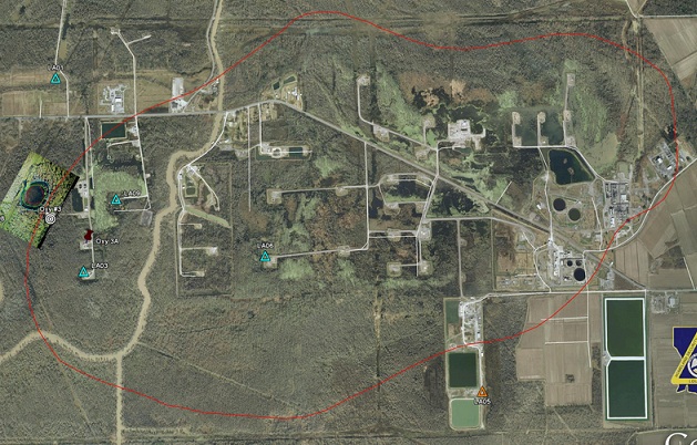
You see the rectangular pads? Those are the cavern wellheads. The sinkhole is on the western edge of this photo
The concern is will cracks spread from the damaged cavern to an adjacent caverns?
And if you look, there are a couple of other caverns near the northwestern edge of the done that could be in jeopardy of being breached in a similar fashion if there is an overhang near them.
The dashed red line shows the approximate upper edge of the dome. We've learned that the area with the collapsed cavern is had an overhang, creating a false idea of the thickness of the wall.
This was blown when a state mandated pressure test exceeded the ability of the salt to withstand the psi and it blew out.
This, along with whatever other natural processes deep in the sediments are happening, caused the sinkhole.
And now we have huge amounts of material from the surface draining into and through this conduit to depths of more than a mile.
edit on 30-4-2013 by jadedANDcynical because: Typos
I have a feeling we need a friendly scientist on this thread. Someone who really knows what they are talking about and - preferably - one on the
inside. At least one who works for the authorities rather than Texas Brine.
Rather like the Nuclear Industry, I suspect that the oil and gas lot will all stick together because they are all in the same boat. Companies who lease the different parts of the dome are all up # creek aithout a paddle and rather like Tepco, they are hoping this thing does not blow up in their face. Unfortunately, like Fuku, there is nothing they can do to stop it.
The different processes of the Earth like the movement of oil, gas, water, etc will expose their greed and corruption in trying to hide the failings of this salt dome. By waiting until now when their hand has been forced, they have wasted time which could be spent either moving people out of the area or by trying to find a (partial) solution to the problem.
Of course, this has HUGE implications for other oil and gas companies and the government who are storing most of the USA's fuel reserves (and other things) in offshore salt domes.
If you go to the search links I gave a page or so back, many of the old 1990's reports are all about where to store the government fuel reserves in case of war etc. Thats all levels of radioactive waste not just NORM.
There are usually 3 things which go together, so I wonder what the third un-stoppable crisis will be (or is!)
reply to post by jadedANDcynical
If you go back to this post you will see, in item 2, that it was not known at the time the well for the salt cavern was drilled but was found out later to be the case.
The dashed red line shows the approximate upper edge of the dome. We've learned that the area with the collapsed cavern is had an overhang, creating a false idea of the thickness of the wall.
If you go back to this post you will see, in item 2, that it was not known at the time the well for the salt cavern was drilled but was found out later to be the case.
2 - If you go back through this thread you will see that some of the early admissions by Texas Brine and some government agencies showed that a test bore that was too close to the edge of the salt dome allowed a blowout of the side of the #3 cavern. This allowed the sinkhole to form just off to the side of the salt dome. Then material in the form of land and vegetation started sinking into the cavern that was breached. The original depth of the cavern was a couple of thousand feet, but as material started filling it through the sinkhole it became shallower until the bottom was only a few hundred feet deep. One of the graphics showed that the salt dome was somewhat mushroom shaped. The graphic showed that the actual wall thickness below the "mushroom cap" was less than what was allowed. But when the well that was used to form the cavern was drilled they didn't know about the "mushroom" shape of the salt dome and were taking their wall thickness readings from the "apparent" full size of the dome, not the actual thickness at the depth of the cavern.edit on 30-4-2013 by happykat39 because: (no reason given)
reply to post by qmantoo
The only salt domes being used are on land and not offshore. Louisiana has 2 of the 4 strategic oil reserves while Texas holds the other two. All being on land.
The only salt domes being used are on land and not offshore. Louisiana has 2 of the 4 strategic oil reserves while Texas holds the other two. All being on land.
Found this while looking around.
"The volume of the sinkhole increased about 300,000 or 400,000 cubic yards in March."
enenews.com...
Parent link.
www.youtube.com...
"The volume of the sinkhole increased about 300,000 or 400,000 cubic yards in March."
enenews.com...
Parent link.
www.youtube.com...
Anyone go to the Parish Meeting on Wednesday?
Commissioners brief the public If so, anything new?
-----------------------------------
2 new bills for tighter control drlling around salt domes (unless they promise not to let sinkholes form perhaps?)
Sinkhole bills approved by Louisiana House
Commissioners brief the public If so, anything new?
-----------------------------------
2 new bills for tighter control drlling around salt domes (unless they promise not to let sinkholes form perhaps?)
Sinkhole bills approved by Louisiana House
The Louisiana House backed two bills Thursday (May 2) aimed at tightening restrictions around the state's salt domes and solution-mined caverns used to store hydrocarbons or hewn for salt in brine production.
House Bills 493 and 494 by Rep. Karen Gaudet St. Germain, D-Pierre Part, were written in response to a 13-acre sinkhole that first appeared in the swamplands of Assumption Parish last August.
The bills would control the drilling, operations and plugging of the brine and storage caverns that have been drilled into the state's salt domes.
There has been another disturbing update from the Assumption Police Jury on Wed 5/1 2013. You can see it at
Celestial Convergence along with the entire 14 part video of the Wednesday meeting.
May 02, 2013 - UNITED STATES - According to Gary Hecox, the CB&I hydrogeologist, the seismic array has been updated at the giant Louisiana sinkhole. "The initial seismic data, what we’re finding — the locations of all the micro-earthquakes have been recorded — as you can expect, most of the micro-earthquakes have been located around the Oxy 3 cavern and in the salt. We do have some minor earthquakes out away from that in the vicinity of the other caverns."
Hecox made these revelations at a public briefing on the sinkhole on Wednesday, May 1st, at the Assumption Parish Community Centre.
edit on 3-5-2013 by happykat39 because: (no reason given)
This does not sound good - This from the May 1 meeting.
Source
Expert: Unfortunately what we warned about appears to be happening — Methane from deep below giant sinkhole is now surfacing in community
Gary Hecox, CB&I hydrogeologist: The thermogenic gas from depth has moved upward and has displaced the shallow swamp gas.
So what we talked to you about last November as one of the concerns we had was the deep gas in the MRAA [Mississippi River Alluvial Aquifer] coming up and displacing the shallow gas […]
So unfortunately what we told you several months ago that may be happening in terms of the deep gas displacing the shallow swamp gas appears to be occurring. […]
At least some of the methane in the community that is being detected has moved its way up from depth and is now coming up in the shallow part of the system […]
Now we know at least one of the bubble sites has a direct connection to gas coming up through the disturbed rock zone into the aquifer and is coming up through the other bubble sites.
Source
edit on 3-5-2013
by Anmarie96 because: (no reason given)
When they say
I guess by 'at least one' they mean MANY and are playing down the seriousness of the situation and trying not to spread alarm into the community. These are real people's lives they are playing with and these people who live in the area should know the real facts not the sanitised and smoothed ones.
When gas comes up through rock and sand it is dispersed and could appear anywhere throughout a wide area. It just depends on the permeability of the underlying strata and where the faults and fissures go. At least we know officially that the gas is from deep below the surface.
Of course, like volcano eruption and earthquake prediction it is a bit of a "finger in the air and test the wind" kind-of situation with no-one (even experts) knowing which way this thing will go, but at least they can tell the ones living there the real facts and the experts opinions.
I am assuming that the micro-earthquakes are caused by stresses and strains in the area and so it is rather like ice flows groaning and squeaking - only normally, these areas should not have these stresses and strains to make the noise.
Is there any way we can plot the locations of these micro-earthquakes? That would be useful to know. I guess it is to do with timings of p-waves and s-waves and when they reach the different recorders. Only the authorities would have that information perhaps, and we only get to see the recorder graphs of the magnitudes.
Is there any data on the amount this thing is rising or falling because it might give us some information about which areas are going to collapse or which areas have more stresses?
Now we know at least one of the bubble sites has a direct connection to gas coming up through the disturbed rock zone into the aquifer and is coming up through the other bubble sites.
I guess by 'at least one' they mean MANY and are playing down the seriousness of the situation and trying not to spread alarm into the community. These are real people's lives they are playing with and these people who live in the area should know the real facts not the sanitised and smoothed ones.
When gas comes up through rock and sand it is dispersed and could appear anywhere throughout a wide area. It just depends on the permeability of the underlying strata and where the faults and fissures go. At least we know officially that the gas is from deep below the surface.
Of course, like volcano eruption and earthquake prediction it is a bit of a "finger in the air and test the wind" kind-of situation with no-one (even experts) knowing which way this thing will go, but at least they can tell the ones living there the real facts and the experts opinions.
I am assuming that the micro-earthquakes are caused by stresses and strains in the area and so it is rather like ice flows groaning and squeaking - only normally, these areas should not have these stresses and strains to make the noise.
Is there any way we can plot the locations of these micro-earthquakes? That would be useful to know. I guess it is to do with timings of p-waves and s-waves and when they reach the different recorders. Only the authorities would have that information perhaps, and we only get to see the recorder graphs of the magnitudes.
Is there any data on the amount this thing is rising or falling because it might give us some information about which areas are going to collapse or which areas have more stresses?
reply to post by qmantoo
An earlier report on the sinkhole did say that the whole area around it is slowly sinking. In fact, this is why they are moving the berms out farther from the sinkhole. So if the whole area around the sinkhole is sinking, where is the material that is allowing the area to sink going to and where in the sinkhole is it coming from??????
Somehow I don't think anyone will like the answers to those questions.
Is there any data on the amount this thing is rising or falling because it might give us some information about which areas are going to collapse or which areas have more stresses?
An earlier report on the sinkhole did say that the whole area around it is slowly sinking. In fact, this is why they are moving the berms out farther from the sinkhole. So if the whole area around the sinkhole is sinking, where is the material that is allowing the area to sink going to and where in the sinkhole is it coming from??????
Somehow I don't think anyone will like the answers to those questions.
Another update from the Assumption Parish
Police Jury issued at 4:05 PM 5/3/2013.
The Office of Conservation, in consultation with Assumption Parish Incident Command, is advising the public that the Oxy 3/sinkhole monitoring alert status has been raised to Code 2 – requiring all work directly on the sinkhole to cease until further notice. Seismic monitoring has detected an increasing trend of micro-earthquake (MEQ) activity in the area around the sinkhole and Oxy 3 over the past few days.
Such activity has previously been noted as a likely indication of shifting and sloughing in the sinkhole and the area below it. The seismic activity is limited to the Oxy 3/sinkhole area, showing no indication of impact to the Oxy 1 area. Monitoring is constantly ongoing in the area and Conservation will advise the public of significant changes in subsurface conditions.
Q, there is one dome down there beneath a good part of the western edge of the city and outskirts, in which there are multiple caverns.
jadedANDcynical - in your post above on this page(and in your first post), where you posted the picture of the extent of the salt dome - this is the extent of the Napoleonville salt dome is it? Or... is it just Oxy3. If just Oxy3, then how large is Napoleonville?
edit on 4 May 2013 by qmantoo because: forgot the link
new topics
-
12 jurors selected in Trump criminal trial
US Political Madness: 1 hours ago -
Iran launches Retalliation Strike 4.18.24
World War Three: 2 hours ago -
Israeli Missile Strikes in Iran, Explosions in Syria + Iraq
World War Three: 2 hours ago -
George Knapp AMA on DI
Area 51 and other Facilities: 8 hours ago -
Not Aliens but a Nazi Occult Inspired and then Science Rendered Design.
Aliens and UFOs: 8 hours ago -
Louisiana Lawmakers Seek to Limit Public Access to Government Records
Political Issues: 10 hours ago -
The Tories may be wiped out after the Election - Serves them Right
Regional Politics: 11 hours ago
top topics
-
BREAKING: O’Keefe Media Uncovers who is really running the White House
US Political Madness: 15 hours ago, 25 flags -
George Knapp AMA on DI
Area 51 and other Facilities: 8 hours ago, 23 flags -
Biden--My Uncle Was Eaten By Cannibals
US Political Madness: 16 hours ago, 18 flags -
Israeli Missile Strikes in Iran, Explosions in Syria + Iraq
World War Three: 2 hours ago, 12 flags -
"We're All Hamas" Heard at Columbia University Protests
Social Issues and Civil Unrest: 16 hours ago, 7 flags -
Louisiana Lawmakers Seek to Limit Public Access to Government Records
Political Issues: 10 hours ago, 7 flags -
So I saw about 30 UFOs in formation last night.
Aliens and UFOs: 13 hours ago, 5 flags -
Not Aliens but a Nazi Occult Inspired and then Science Rendered Design.
Aliens and UFOs: 8 hours ago, 4 flags -
Iran launches Retalliation Strike 4.18.24
World War Three: 2 hours ago, 4 flags -
The Tories may be wiped out after the Election - Serves them Right
Regional Politics: 11 hours ago, 3 flags
active topics
-
12 jurors selected in Trump criminal trial
US Political Madness • 20 • : Lumenari -
MULTIPLE SKYMASTER MESSAGES GOING OUT
World War Three • 43 • : SchrodingersRat -
Pfizer is 'deeply sorry'
Diseases and Pandemics • 23 • : VoiceofReality -
Israeli Missile Strikes in Iran, Explosions in Syria + Iraq
World War Three • 47 • : YourFaceAgain -
It has begun... Iran begins attack on Israel, launches tons of drones towards the country
World War Three • 887 • : 5thHead -
The Tories may be wiped out after the Election - Serves them Right
Regional Politics • 20 • : ScarletDarkness -
Terrifying Encounters With The Black Eyed Kids
Paranormal Studies • 44 • : Consvoli -
George Knapp AMA on DI
Area 51 and other Facilities • 20 • : theshadowknows -
BREAKING: O’Keefe Media Uncovers who is really running the White House
US Political Madness • 14 • : pianopraze -
British TV Presenter Refuses To Use Guest's Preferred Pronouns
Education and Media • 63 • : Consvoli