It looks like you're using an Ad Blocker.
Please white-list or disable AboveTopSecret.com in your ad-blocking tool.
Thank you.
Some features of ATS will be disabled while you continue to use an ad-blocker.

Tremors felt 45 miles away from Bayou Corne Sinkhole!
page: 80share:
Unfortunately, it is a lot, lot larger than that. See this page
Oxy Geismar 003 which states that it has a depth of 5926 (feet or meters?) last measured in 1989 and there are quite a few salt domes down there all technically connected (by an area of salt?) I seem to remember.
The search facility produces a PDF, so input x-cordinate 2060646 and y-coordinate 488416 and plug in your radius at the search page
here is the latest fly over. Oil sheen is still there and we can now see what tress are alive & which ones are dead.
Originally posted by jadedANDcynical
reply to post by jadedANDcynical
Fountains of Methane 1000m across Erupt From Arctic Ice!
Anyway, if whatever caused these methane fountains were to do something similar under, say Louisiana, what would it look like?
What if there's a hydrate deposit down near where the salt dome base is and it has been disturbed by the collapsed cavern?edit on 20-4-2013 by jadedANDcynical because: Fixed ex tag
Bravo Jaded, as I read your post and thought on it, I have to say that I agree with your question you asked at the end. I am thinking that this could be the case of the ground/salt dome was compromised and we are seeing the escape. Which then leads me to other questions. This winter we were seeing and hearing of methane bubbling up. Because of the rains the area was receiving it was easy to find the bubbling sites. What about now? The only think I would think that would give away methane escaping would be the vegetation. We know that methane was found under two house across the road, what was the end result, I do not know. But are residents seeing trees that aren't budding and leafing? Does this make sense?
reply to post by qmantoo
As I understand the sinkhole doesn't go into the salt dome. This link will give a good visual of where the sinkhole is and where the dome is.
[url=www.nola.com/environment/index.ssf/2012/08
The collapse is not shown in the pictures. Now we see the cap rock in the diagram and I do think there is an issue with that because we had the release of Hydrogen sulphide and the cap rock is usually where it is found.
** I would link some more images but I have yet to master how to do images. Kat has tried to teach me numerous times.
AuntB - forgive me for being cynical, but .... how do we know that the sinkhole has not breached the salt dome?
Where did all the oil and muck come from? I seem to remember that they put that stuff in the top of the contents and a layer of diesel to 'seal it'. Why does the sinkhole keep getting larger? I understood that the walls of the salt dome were collapsing, causing smallish quakes and 'burping' up gas and muck from the depths?
(The image you linked to here) shows the sinkhole off to the right of the salt dome in the picture, and shows a very small 'cavern' where the company was pouring hot water down into to dissolve the salt. We have to remember that this salt dome was plugged, so either it was dodgy or else they had extracted all the salt (more likely) We know that the contents of at least one of the domes was low level "harmless" radioactive NORM waste from drilling operation, and we know that there has been various oil byproducts found at the surface. This makes me suspect that it has been breached, no?
Originally posted by qmantoo
AuntB - forgive me for being cynical, but .... how do we know that the sinkhole has not breached the salt dome?
Where did all the oil and muck come from? I seem to remember that they put that stuff in the top of the contents and a layer of diesel to 'seal it'. Why does the sinkhole keep getting larger? I understood that the walls of the salt dome were collapsing, causing smallish quakes and 'burping' up gas and muck from the depths?
(The image you linked to here) shows the sinkhole off to the right of the salt dome in the picture, and shows a very small 'cavern' where the company was pouring hot water down into to dissolve the salt. We have to remember that this salt dome was plugged, so either it was dodgy or else they had extracted all the salt (more likely) We know that the contents of at least one of the domes was low level "harmless" radioactive NORM waste from drilling operation, and we know that there has been various oil byproducts found at the surface. This makes me suspect that it has been breached, no?
We don't but those are the images what they are showing us. Months back they actually tested what was in the collapsed cavern. Those results have never been released. We do know that the floor has been moving upward, actually the floor itself isn't moving up but it is filling with ??????. Because it is filling with????? this is why they think it (sinkhole) will be stabilized. Now those various oil products... those have been tested also but we don't get results on those either. Actually they basically don't tell the public $h!t.
how do we know that the sinkhole has not breached the salt dome?
*BTW- I do think there is a seepage between the sinkhole and the cavern.
edit on 25-4-2013 by AuntB because: add on
reply to post by AuntB
Hi AuntB
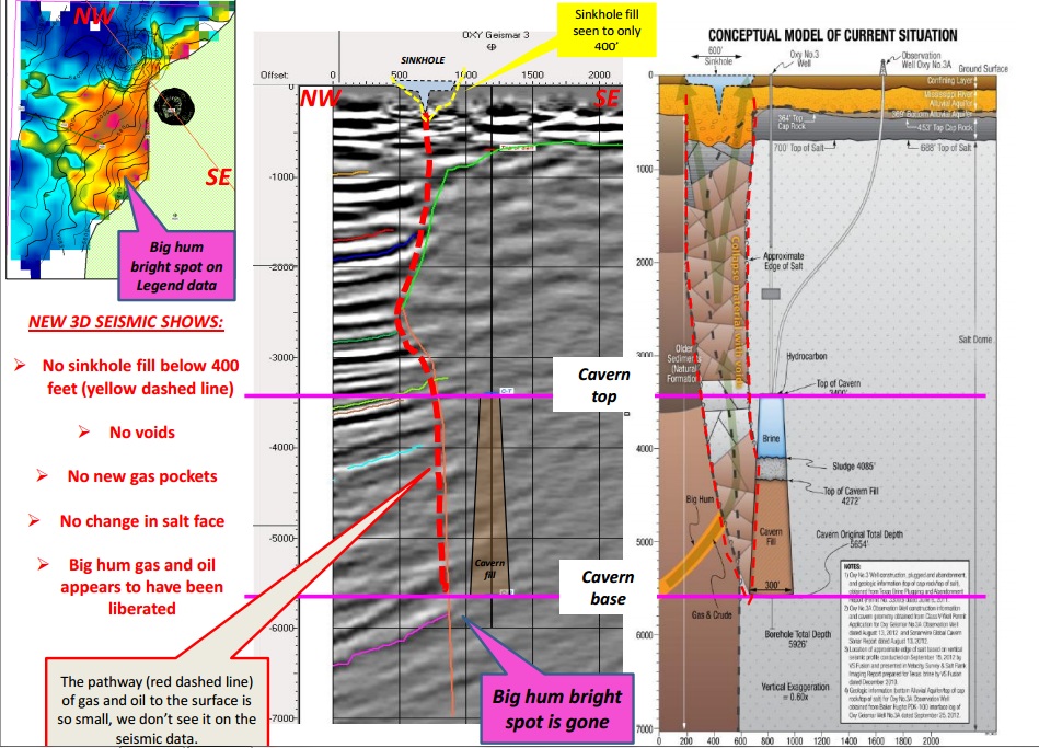
If you believe the results of the 3D seismic imaging report released on 22 April, 2013, the sinkhole does not breach the salt dome. Possibly, the Oxy3 brine cavern did.
The Louisiana DNR is having their own specialist comb through the seismic data and give their own independent results, but those aren't available yet.
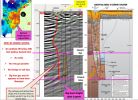
Here is a thumbnail of some of the imaging side-by-side with the conceptual model done by CB&I a few months back.
The lines on the left of the seismic image are natural bedded sedimentary layers.
The monolith of gray to the right of the red dashed line is the salt dome.
The red dashed line is the path of hydrocarbons to the sinkhole.
Hi AuntB
If you believe the results of the 3D seismic imaging report released on 22 April, 2013, the sinkhole does not breach the salt dome. Possibly, the Oxy3 brine cavern did.
The Louisiana DNR is having their own specialist comb through the seismic data and give their own independent results, but those aren't available yet.
Here is a thumbnail of some of the imaging side-by-side with the conceptual model done by CB&I a few months back.
The lines on the left of the seismic image are natural bedded sedimentary layers.
The monolith of gray to the right of the red dashed line is the salt dome.
The red dashed line is the path of hydrocarbons to the sinkhole.
edit on 4/25/2013 by Olivine because: (no reason given)
reply to post by Olivine
Brilliant post Olivine!
Just in case anyone didn't pick up on this, the "Big hum gas and oil appears to have been liberated" is indicative of what I've referenced before with this being tied to processes deeper down.
This also explains the hydrocarbons being skimmed off the surface of the sinkhole (continuously still?) that had been reported.
That's at around 6000 feet in depth, or a bit over a mile beneath the surface. It's coming from even deeper than that if you look at the diagram.
The actual source is still out of imaging range. Or at least images that have been released.
Olivine, I could not get the underlined link to the report to work so here is another to the powerpoint presentation
Bayou Corne 3d reflection seismic results
What concerns me is that the red dotted line seems to somehow spookily manage to find the sinkhole at the surface. It has reached up 5600 feet from below the salt where it just happens to meet the surface at that point, but why not anywhere else? What is special about where the sinkhole formed?
Looking at the grey area on the left, it seems like there is a natural vertical borderline between two kinds of material or density (left/right) where the red dotted line shows the pathway of the oil and gas rising up to the surface.
reply to post by qmantoo
By the rules of physics, whatever is rising, it will find the path of least resistance to where it begins to show itself: i.e. the sinkhole at the surface.....
we are assuming that whatever is seeking stabiliization, in other words, what is lighter than the water density, is coming from that salt cavern, something having been stored there. And that is what created this destabilization of land" so that homeowners began to question the stability of their homes, with good reasons, and what may lie beneath those homes and what then, could possibly be leaking and rising to the surface and caused such as abridgement of soil, land, etc....
As for Aunt B's post about being told that once what is within the leaking cavern finds stability between itself and the pressure created on the top of the dome by the water above it, and then the top of the cavern being stable, that stability, I assume they are proposing, will come because the pressure in that salt cavern where whatever is stored and is now leaking from it, will reach a stasis or equilibrium point with the water pressure above the dome, itself. The philosophy makes sense, but if it actually behaves in that manner is another question entirely, and does assume that what has been released information-wise thus far is the truth.....big assumption......though
reply to post by qmantoo
Sorry 'bout that. I'm not sure why it didn't work.
This link is to the Bayou Corne page at DNR: this should work
The link to the PDF report I referenced above is halfway down the page in yellow.
I'll try the direct link again: pdf
Million dollar question--I guess the area of the sinkhole could have had hydrocarbons underneath the area for some time; saturating and weakening the sedimentary rocks underlying it, until they eventually failed.
Sorry 'bout that. I'm not sure why it didn't work.
This link is to the Bayou Corne page at DNR: this should work
The link to the PDF report I referenced above is halfway down the page in yellow.
I'll try the direct link again: pdf
What is special about where the sinkhole formed?
Million dollar question--I guess the area of the sinkhole could have had hydrocarbons underneath the area for some time; saturating and weakening the sedimentary rocks underlying it, until they eventually failed.
edit on 4/25/2013 by Olivine because: (no reason given)
I have been following, and contributing to, this thread for quite some time. Here are some of my thoughts on this disaster...
1 - I believe that the nature of the geology of the area would have eventually produced a disaster of some kind if the idiots operating the salt dome caverns had not beat nature to the punch. There is now credible evidence that at least part of what is making this event as bad as it is can be traced back to the B P Deepwater Horizon/Macondo well blowout. It is now known that the well was never completely sealed and that seepage of the very hot and high pressure gas and oil is causing a bulge in the gulf sea floor encompassing a 25 mile radius, or more now, around the original blowout. And there is very credible suspicion that some of that gas and oil is what is coming up through the ground as far inland as Lake Peignoir after having forced it's way through the geologic strata of the area.
2 - If you go back through this thread you will see that some of the early admissions by Texas Brine and some government agencies showed that a test bore that was too close to the edge of the salt dome allowed a blowout of the side of the #3 cavern. This allowed the sinkhole to form just off to the side of the salt dome. Then material in the form of land and vegetation started sinking into the cavern that was breached. The original depth of the cavern was a couple of thousand feet, but as material started filling it through the sinkhole it became shallower until the bottom was only a few hundred feet deep. One of the graphics showed that the salt dome was somewhat mushroom shaped. The graphic showed that the actual wall thickness below the "mushroom cap" was less than what was allowed. But when the well that was used to form the cavern was drilled they didn't know about the "mushroom" shape of the salt dome and were taking their wall thickness readings from the "apparent" full size of the dome, not the actual thickness at the depth of the cavern.
3 - another admission let us know that there was a flow of something through the sinkhole. It could have been water, oil or gas (or a combination of any or all of them) which is suspected of making the sinkhole worse and causing the "burps" which are most likely being caused by the gas. Anything flowing through a material as fragile as salt will wear it away either by dissolving it or eroding it. So, at this point in time, we still don't know if the worst of the sinkhole is over or if it is still to come.
4 - Now with the new info and graphics, we don't know what the truth about the sinkhole really is. Did they lie to us then or are they lying to us now? Or worse yet, do they even know what is going on? And, how much are they still holding back on the truth.
5 - Even though it is the most unlikely result of the sinkhole, the worst case scenario still includes the rupture of the fault system that includes the New Madrid fault zone. This could lead to nothing more than a few earthquakes of questionable magnitude. Or it could end up dividing the country in two from the great lakes to the gulf as prophesied by Edgar Cayce and illustrated by a map produced by the United States Navy.
6 - Even discounting the lies and coverups by Texas brine and the government agencies involved, we still have no real idea of what is going on underground and where it will lead. I have been saying for quite some time that this is playing out like a train wreck in slow motion, and we can't see where the rails lead to around the curves ahead.
Happykat, That is a very good synopsis of the situation.
Very well put, and I have to agree with you. On all points.
I, myself, just being on this thread, I have learned a lot of things.
A thank you to all.
Very well put, and I have to agree with you. On all points.
I, myself, just being on this thread, I have learned a lot of things.
A thank you to all.
I guess we better move the berm. The old one might go in. lol
"The Office of Conservation, in consultation with Assumption Parish Incident Command, is advising the public that Texas Brine is preparing to re-route the western wall of the sinkhole containment berm further west, and extend the northern and southern berm walls accordingly, due to ongoing surface subsidence in a portion of the existing western berm wall."
assumptionla.wordpress.com...
Great write up Happy Cat!
reply to post by AuntB
It is filling with the material from the 'slumps' that you can see on the seismos.
The walls slump and fall to the bottom.
actually the floor itself isn't moving up but it is filling with ??????. Because it is filling with????? this is why they think it (sinkhole) will be stabilized.
It is filling with the material from the 'slumps' that you can see on the seismos.
The walls slump and fall to the bottom.
reply to post by Aircooled
That berm has been sinking for almost a month now. I believe if you go a few pages back I reported it. Last night as I was listening to Coast to Coast, Linda Moulton Howe was discussing all her research in multiple topics. In the second hour she discussed mysterious geological events in the earth and how soil liquidation is happening more frequently now. I WILL have to go back and listen to it sometime today.
Other than that, all quiet down here really. Had a blast of rain two days ago, spawned up a few tornadoes in NOLA. Just the other day I was going down a back road through Chacahoula where the Chacahoula salt dome is located. There is a turn off with a Texas Brine sign I so want to vandalize...
Oil and Gas Hearings
Might be worth a visit and might yield some interesting snippits of info perhaps if anyone is interested. Dont know if it is open to the public.
From the DNR Louisana Gov. Calendar 30th of April (this coming Tuesday)
Tuesday | April 30, 2013 Location: LaSalle Building, 1st Floor, LaBelle Room, Baton Rouge
Oil and Gas Hearings
This page does not give details of future hearings, only past ones
=============================
just so we have this documented
wikimap page
Nearby cities: Houma, Louisiana; Baton Rouge, Louisiana; Bayou Gauche, Louisiana
Coordinates: 30°0'38"N 91°8'34"W
oldish map of sinkhole
==================================
This one is for Chacahoula salt dome, but I am trying to find this kind of thing for Napoleonville salt dome.
Chacahoula salt dome, eight miles southwest of Thibodaux, LA, could be solution mined to create caverns for storing as much as 500 million barrels (MMB) of crude oil, should the Strategic Petroleum Reserve (SPR) require additional storage volume. The salt mass geometry is confirmed by more than 50 oil wells, and also from previous exploratory drilling for sulphur. Top of salt occurs at [minus]1100 ft, and some 1300 acres exist within the [minus]2000 ft salt contour. Frasch mining of 1.35 million long tons of sulphur caused the surface to subside about one foot on the northeastern part of the dome. Creep-induced subsidence averaging [approximately]2.7 ft over 30 yrs is estimated for a 200 MMB cavern array, which would require perimeter diking to control localized perennial flooding. Earthquakes approaching intensity MM 6 have occurred nearby and are expected to recur on the order of [approximately]100 yrs but would not affect cavern stability. Additional study of brine disposal methods and hurricane surge probabilities are needed to establish design parameters and cost estimates for storage
edit on 26 Apr 2013 by qmantoo because: hearings link
reply to post by qmantoo
You probably wont find this kind of documentation for the Napoleonville Salt Dome. The reason is for the study of the Chacahoula salt dome is that the government wants/wanted to put a strategic oil reserve in there. If I am correct it is on hiatus right now due to the economy. This dome is located less than 15 miles from me.
You probably wont find this kind of documentation for the Napoleonville Salt Dome. The reason is for the study of the Chacahoula salt dome is that the government wants/wanted to put a strategic oil reserve in there. If I am correct it is on hiatus right now due to the economy. This dome is located less than 15 miles from me.
In today's journey down various rabbit holes, I found that using this pdf and this search facility you can find out all the technical details about a
well. where it is, depth, height, latitude, longitude, what it contains, status, etc.
Download this PDF which gives the
oct 2012 wellnames, companies, wellnumbers
get the Well Serial Number from 3rd column, insert it into the [well serial number goes here] field in the URL below
Then place "http://" at the start of this URL
sonlite.dnr.state.la.us/sundown/cart_prod/cart_con_wellinfo2?p_wsn=[well serial number goes here]
Search for interesting documents
Search for PDFs here in this case with search words "salt dome louisiana"
and here with search terms "napoleonville salt dome"
Second quarter 2013 storage plan (for the next couple of years)
Release Date: 2013Q2
Second quarter 2013 salt dome storage plan for 2013/14/15
edit on 27 Apr 2013 by qmantoo because: typo
Taking q's cue in queuing up different searches, I've come across the following article. Again, it's older but it still bears upon the current
discussion.
Sediments in Northern Gulf of Mexico Not Right for Methane Gas Hydrate Formation
This being the case, it then also seems unlikely to be a full hydrate deposit below the sinkhole. That does not preclude other forms of methane in the various strata below the area of the salt dome.
It's obvious that the majority of what they skimmed off the top of the sinkhole was the large reservoir of the Big Hum. That particular layer of strata seems to have filled up with hydrocarbons fed from further down and depending on the amount that's left and how much pressure it's under, we may see a much larger exchange of surface and subsurface material.
Think about this, if you've seen this toy you'll understand what I'm talking about.
You've got the debris like from where the cavern collapsed and then dropped, everything above dropped as well creating the sinkhole. Every time there is a slough in or burp, material is being churned up. Some from the top is trading places with some from further down.
There's absolutely no way to be able to estimate how large It will grow to encompass, so the people that live nearby, as sad as sad it is to suggest, might want to start looking elsewhere.
All of this is taking place in the range of hundreds to thousands of feet below the surface. Well out of the reach of anything we can do. This is exactly like Fukushima in that the technology does not exist to deal with the problem as presented. The only thing that can be done is mitigation. There is no repair that can be made.
Watching and waiting is all that can be done so watch and wait we do.
I will say that I think hat this along with many other phenomena are all related to a global event.
I think I may do a thread tying all of this stuff together at some point. I'll let you guys know if you're interested.
Sediments in Northern Gulf of Mexico Not Right for Methane Gas Hydrate Formation
Marine sediments in the northern Gulf of Mexico are likely too warm and salty to hold the amount of methane gas hydrates – a potential energy resource – originally thought to exist in the ocean floor there.
This being the case, it then also seems unlikely to be a full hydrate deposit below the sinkhole. That does not preclude other forms of methane in the various strata below the area of the salt dome.
It's obvious that the majority of what they skimmed off the top of the sinkhole was the large reservoir of the Big Hum. That particular layer of strata seems to have filled up with hydrocarbons fed from further down and depending on the amount that's left and how much pressure it's under, we may see a much larger exchange of surface and subsurface material.
Think about this, if you've seen this toy you'll understand what I'm talking about.
You've got the debris like from where the cavern collapsed and then dropped, everything above dropped as well creating the sinkhole. Every time there is a slough in or burp, material is being churned up. Some from the top is trading places with some from further down.
There's absolutely no way to be able to estimate how large It will grow to encompass, so the people that live nearby, as sad as sad it is to suggest, might want to start looking elsewhere.
All of this is taking place in the range of hundreds to thousands of feet below the surface. Well out of the reach of anything we can do. This is exactly like Fukushima in that the technology does not exist to deal with the problem as presented. The only thing that can be done is mitigation. There is no repair that can be made.
Watching and waiting is all that can be done so watch and wait we do.
I will say that I think hat this along with many other phenomena are all related to a global event.
I think I may do a thread tying all of this stuff together at some point. I'll let you guys know if you're interested.
new topics
-
God's Righteousness is Greater than Our Wrath
Religion, Faith, And Theology: 1 hours ago -
Electrical tricks for saving money
Education and Media: 4 hours ago -
VP's Secret Service agent brawls with other agents at Andrews
Mainstream News: 6 hours ago -
Sunak spinning the sickness figures
Other Current Events: 6 hours ago -
Nearly 70% Of Americans Want Talks To End War In Ukraine
Political Issues: 6 hours ago -
Late Night with the Devil - a really good unusual modern horror film.
Movies: 8 hours ago -
Cats Used as Live Bait to Train Ferocious Pitbulls in Illegal NYC Dogfighting
Social Issues and Civil Unrest: 10 hours ago
top topics
-
Florida man's trip overseas ends in shock over $143,000 T-Mobile phone bill
Social Issues and Civil Unrest: 17 hours ago, 8 flags -
Cats Used as Live Bait to Train Ferocious Pitbulls in Illegal NYC Dogfighting
Social Issues and Civil Unrest: 10 hours ago, 8 flags -
VP's Secret Service agent brawls with other agents at Andrews
Mainstream News: 6 hours ago, 8 flags -
Bobiverse
Fantasy & Science Fiction: 17 hours ago, 3 flags -
HORRIBLE !! Russian Soldier Drinking Own Urine To Survive In Battle
World War Three: 14 hours ago, 3 flags -
Electrical tricks for saving money
Education and Media: 4 hours ago, 3 flags -
Nearly 70% Of Americans Want Talks To End War In Ukraine
Political Issues: 6 hours ago, 3 flags -
Sunak spinning the sickness figures
Other Current Events: 6 hours ago, 3 flags -
Late Night with the Devil - a really good unusual modern horror film.
Movies: 8 hours ago, 2 flags -
The Good News According to Jesus - Episode 1
Religion, Faith, And Theology: 12 hours ago, 1 flags
active topics
-
Electrical tricks for saving money
Education and Media • 4 • : Lumenari -
Cats Used as Live Bait to Train Ferocious Pitbulls in Illegal NYC Dogfighting
Social Issues and Civil Unrest • 19 • : WeMustCare -
VP's Secret Service agent brawls with other agents at Andrews
Mainstream News • 38 • : SchrodingersRat -
New whistleblower Jason Sands speaks on Twitter Spaces last night.
Aliens and UFOs • 54 • : Ophiuchus1 -
DONALD J. TRUMP - 2024 Candidate for President - His Communications to Americans and the World.
2024 Elections • 514 • : WeMustCare -
The Acronym Game .. Pt.3
General Chit Chat • 7744 • : bally001 -
Truth Social goes public, be careful not to lose your money
Mainstream News • 128 • : Astyanax -
Sunak spinning the sickness figures
Other Current Events • 5 • : glen200376 -
SETI chief says US has no evidence for alien technology. 'And we never have'
Aliens and UFOs • 44 • : MikeDeGrasseTyson -
HORRIBLE !! Russian Soldier Drinking Own Urine To Survive In Battle
World War Three • 31 • : budzprime69