It looks like you're using an Ad Blocker.
Please white-list or disable AboveTopSecret.com in your ad-blocking tool.
Thank you.
Some features of ATS will be disabled while you continue to use an ad-blocker.

Tremors felt 45 miles away from Bayou Corne Sinkhole!
page: 67share:
reply to post by Olivine
Some volcanoes have rested 100 million years between major eruptions. I was just watching a documentary about that. They know this because of ash layers in the geologic record. Point is, any one of the major calderas could reactivate at any time, and it was proven not long ago that rising magma under pressure can melt upper crust layers much faster than previously thought.
And it makes sense really, seeing as a huge magma body will have such intense heat that if additional intrusion occurs from way deep down near the mantle, undetected, it could burn its way through now solid rock to the surface within months. The planet could be in real trouble if another continental flood basalt (CFB) ever decided to rear its ugly head again. Or if a new one formed, like potentially out there in the south Pacific.
They are hiding the full coordinates. I'm sure of it. What scientist, seeking absolute accuracy, would settle for 4 decimal places? Not a chance. And after clicking around various networks at the IRIS MDA link I gave, nope, they are all 2 decimal places. So stick to using Quackery for metadata on stations, and you can at least get within 35 feet or so.
It does make me question the accuracy of programs like GEE, and it may be another reason why it takes stepping up to some pretty serious stuff before you can do epicenter locating. I still can't do it, even after begging for them to include it. They don't want amateurs having that capability, and that much has become clear- not from speculation- but from talking with my contacts. Otherwise, IRIS would provide exacting coordinates down to SIX decimal places or better.
As to an asphalt volcano possibly emerging at the LA sinkhole, the elements of methane and oil are there, and they are found near salt domes, according to what I read. I think they were first discovered around 2002, and there are some off the coast of California as well. So there is a slight possibility.
But it would be a total trip if an ancient volcano buried deep under there started reactivating. Highly improbable, but possible. I've been studying the particulars of eruptive sequences, and an interesting thing occurred at one of them where magma rose, but then it stopped being blocked for a bit. And that in turn caused gas emissions to stop as well. 3 days later, kapow. Sure makes me wonder about a situation like Yellowstone or Toba, and what kind of pressure could be building when the gas emissions stop or become greatly reduced. It could be due to blockages that are getting ready to go boom. So yeah, seismicity is still probably the most important element to monitor.
Anyways, I digress and went off on a tangent. Now we're back to daytime and I see the low frequency has returned at the sinkhole, on all stations. But not paying it any more attention. Pretty sure it is cultural noise. Either that, or we are having a real bad case of these tremor type signatures appearing coincident with daylight hours and machinery working the site, and being mistaken for cultural noise. Chances are low of that. I'm sticking with noise until I see something that obviously rises above it. So yeah, all you's watching the helicorders, if it isn't short and spiky, forget it. Or dwell on noise. Your choice.
Wow, Happykcat.........I might just think, we have the Titanic and the Lusitana, going full speed ahead. Well, I don't have to say how well those two
turned out. I still think about this everyday, Not like giving me an ulcer thinking, but my job is pretty boring, and I need to amuse myself somehow.
Not that this is amusing, not by a long shot. Just the aftermath that could happen, I live far enough, but, I will be affected in a big way.
It's ok TA I don't mind it not being volcanic.
I'm currently suffering the mid-throws of insomnia and lack of coffee in my system though. I did find I could view YC sinkhole helicorders in the Iris Bud explorer in the wee hours of the night. Though when you compare the Iris to Ceri you have to be careful to match up the UTC times as the two use different layouts. (Grumble-grumble lack of standardization grumble.)
I also share your annoyance in that the amateur/hobbyist/expert sharing of data resources sucks at times. Though I can understand the reluctance to put location data out there where Joe Luddite and his GPS can go and smash sensors.
On my wish list of things, I wish I knew what the base salinity of the area was before the sinkhole started, and its current salinity at various levels in the hole. From what I understand Lake Peigneur changed from fresh water to saltwater due to the back flow of the swamps/salt cavern flood, which may mean even more environmental damage along with the nasty chemicals in the brine caverns.
Also it seems like the Iris Bud and the Ceri Helicorders are reading at different sensitivity levels, Iris seems much cleaner than the Ceri.
M.
edit on 19-3-2013 by Moshpet because: 42
edit on 19-3-2013 by Moshpet because: Knew, new, nue
Just In: “We went into a ‘Code 3’” last week at giant sinkhole — ‘Maximum state of alert’ (VIDEO)
enenews.com...
Link doesnt seem to have video. Audio only.
enenews.com...
Link doesnt seem to have video. Audio only.
Originally posted by riverwild
Just In: “We went into a ‘Code 3’” last week at giant sinkhole — ‘Maximum state of alert’ (VIDEO)
enenews.com...
Link doesnt seem to have video. Audio only.
Usually Enews is on the ball and ahead of the game when it comes to this kind of news. Sadly they kind of missed this one by about a week. But as they are mostly on top of their game, I keep them in my news feed.
M.
This is the IRIS Bud webicorder of the current time.
And this is the CERI Webicorder of the same time frame.
In the IRIS webicorder you can tell that the pulses that are at 1 minute apart are clearly man made, as nature is rarely if ever, that consistent.
It is so annoying that the level of detail between the two sources is that glaring.
M.
And this is the CERI Webicorder of the same time frame.
In the IRIS webicorder you can tell that the pulses that are at 1 minute apart are clearly man made, as nature is rarely if ever, that consistent.
It is so annoying that the level of detail between the two sources is that glaring.
M.
Excuse me while I vomit. He probably brought a photog so he can show the world he is on it & in charge. Tomorrows papers will show him in a hard hat looking concerned, 7 months after the fact.
Originally posted by CajunBoy
Jindal arrived in Bayou Corne around 2pm today.
He didn't even drive out to it! He flew over it. I really could call him a filthy name.
edit on 19-3-2013 by AuntB because: (no reason
given)
I know this might not be the answer, but cant we get someone to go out there with a GPS system and measure the locations of these seismic stations?
Maybe even in the middle of the night if it means getting the true data and being able to work out the P & S waves accurately.
The orbiting satellites give us accurate topographical data and they monitor Yellowstone all the time to find out if the dome is raising etc. I wonder if we can put our hands on some laser height data of the area and so we can plot it to see if it is moving upwards? Maybe we have contacts in the Universities who can get the data for us. We really need it on an ongoing basis so that we can check out the seriousness of it all.
The orbiting satellites give us accurate topographical data and they monitor Yellowstone all the time to find out if the dome is raising etc. I wonder if we can put our hands on some laser height data of the area and so we can plot it to see if it is moving upwards? Maybe we have contacts in the Universities who can get the data for us. We really need it on an ongoing basis so that we can check out the seriousness of it all.
reply to post by qmantoo
lol... You guys thinking it's just old "conspiracy theory TA," being paranoid about those coordinates? Ha ... Check out the often posted, new USGS real-time map. Carefully move your mouse around the map window. And pay close attention to the numbers moving in the lower right hand corner of that window. Now would someone tell me how many decimal places there are in those coordinates...???
earthquake.usgs.gov...
Thank you. I rest my case.
They'll give us exacting coordinates to a quake epicenter, but won't give us exacting coordinates to the seismic stations that measured them? Not even in special software like GEE?
We're all vandals, I swear. :shk: When was the last time you saw some bozo criminal taking a deep enough interest in seismology to give two flying craps about a program like GEE? Much less three flying craps about the exact location of a seismic instrument 300 feet down a borehole, and sealed in a hardened concrete bunker?
EDIT: And here, allow me, before the sukkas see this post and then deliberately change it to 4 decimal places:
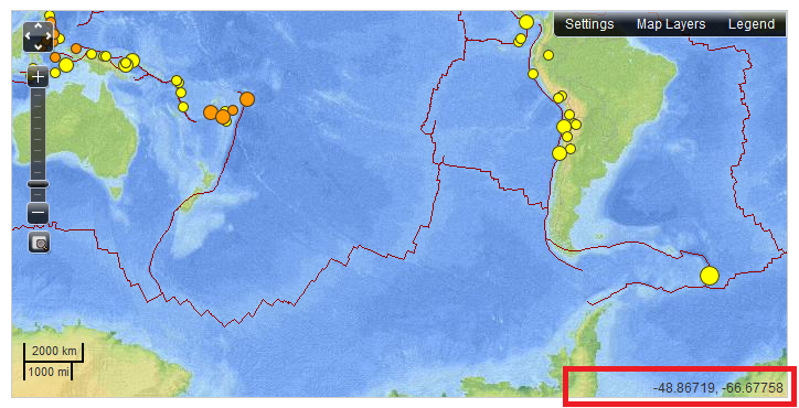
See the red rectangle I drew on there, lower right. That is a screencap from a map today, with my mouse at some unimportant position.
ANYWAYS... back off tangent, and on to seismicity at the sinkhole... *sigh*
I think there has been some very small quakes since last update, but overall it has subsided substantially from the sharper signatures of March 13.
lol... You guys thinking it's just old "conspiracy theory TA," being paranoid about those coordinates? Ha ... Check out the often posted, new USGS real-time map. Carefully move your mouse around the map window. And pay close attention to the numbers moving in the lower right hand corner of that window. Now would someone tell me how many decimal places there are in those coordinates...???
earthquake.usgs.gov...
Thank you. I rest my case.
They'll give us exacting coordinates to a quake epicenter, but won't give us exacting coordinates to the seismic stations that measured them? Not even in special software like GEE?
We're all vandals, I swear. :shk: When was the last time you saw some bozo criminal taking a deep enough interest in seismology to give two flying craps about a program like GEE? Much less three flying craps about the exact location of a seismic instrument 300 feet down a borehole, and sealed in a hardened concrete bunker?
EDIT: And here, allow me, before the sukkas see this post and then deliberately change it to 4 decimal places:
See the red rectangle I drew on there, lower right. That is a screencap from a map today, with my mouse at some unimportant position.
ANYWAYS... back off tangent, and on to seismicity at the sinkhole... *sigh*
I think there has been some very small quakes since last update, but overall it has subsided substantially from the sharper signatures of March 13.
edit on Wed Mar 20th 2013 by TrueAmerican because: (no reason given)
Wanted to pop in and drop a few links and thanks:
Google Scholar search for Louisiana salt dome tectonics most of these are pay walled, but there is still some interesting information and hints in the abstracts.
Gulf of Mexico geology search at Google Scholar a lot of these are open access and have a ton of information for the technically minded.
I'm posting from my iPhone so my capacity for excerpting is limited, but there is a lot to be found in these documents.
To the thanks:
TA, I cannot tell you how much I appreciate your input on this thread. Your ability and knowledge about the subject and your record here sets my mind at ease in knowing we've got one of the best pro-am seismic minds in the world watching what's going on in the Louisiana swamps.
Olivine, you seem to have a knack for asking pertinent and thoughtful questions and I've always held the opinion that you can often learn more from questions than you do from answers. Keep it up.
CajunBoy - nothing, and I mean NOTHING, like having boots on the ground. I know how deeply this must be affecting you and I want you to know that you've got lots of support here from many on ATS.
Special shout out to all of you who have also followed the Fukushima thread and big nods to seeing the similarities in how both disasters have been handled by those "in charge."
I haven't posted much in a while; have had a LOT going on personally but I have kept up to date on a few threads, this being one of the foremost.
One of the things I've learned over the last couple of years here at ATS is that there are many times more connections in a story than are generally apparent at first glance.
The more you learn, the more find that there is to learn and thus, the rabbit hole always grows...
13 acres???
Gov. Bobby Jindal pledged Tuesday to hold Texas Brine Co. LLC’s “feet to the fire” over buyouts for residents affected by a growing, 13-acre sinkhole in northern Assumption Parish.
These pictures are floating around as the latest flyover. I don't see significant growth. It was 9 acres, now 13???
20130319 - Bayou Corne Flyover #5
Governor: ‘Solvents’ being released from giant sinkhole —
Not only oilSolvents are being released. What exactly does this mean. A little more detail would be great. I am starting to think that these
citizens as part of the buyout should receive healthcare from Texas brine in case these "solvents" cause future health issues.
Originally posted by AuntB
Governor: ‘Solvents’ being released from giant sinkhole — Not only oilSolvents are being released. What exactly does this mean. A little more detail would be great. I am starting to think that these citizens as part of the buyout should receive healthcare from Texas brine in case these "solvents" cause future health issues.
At the bottom of the article at your link it mentions acetone. I also think I read somewhere that either benzene, xylol (xylene) or both are stored in the caverns in the Napoleonville salt dome. Benzene is highly carcinogenic and xylol is a very powerful solvent that is also very dangerous to the environment.
You can get a copy of the acetone MSDS (Material Data Safety Sheet) HERE
You can get a copy of the benzene MSDS HERE
And a copy of the zylol MSDS HERE
reply to post by happykat39
Every single one of those chemicals you listed are highly dangerous to absolutely everything and everyone. Just the acetone. Think about the effects of fingernail polish remover all over your skin, all over plants, etc....
This, as everyone keeps saying, just keeps getting worse. Not to mention, why in the world would you be filling underground, in a swamp, caverns with these chemicals?????
edit on 20-3-2013 by tetra50 because: (no reason given)
Originally posted by tetra50
reply to post by happykat39
Every single one of those chemicals you listed are highly dangerous to absolutely everything and everyone. Just the acetone. Think about the effects of fingernail polish remover all over your skin, all over plants, etc....
This, as everyone keeps saying, just keeps getting worse. Not to mention, why in the world would you be filling underground, in a swamp, caverns with these chemicals?????edit on 20-3-2013 by tetra50 because: (no reason given)
Being in the salt domes they are supposed to be "leak proof". But I feel the same way about that supposedly leak proof thing as I do about buying a house that needs a sump pump. If the house needs a sump pump then one day the pump is going to fail when it is needed and you will get flooded. Sooner or later that is a statistical certainty, and so is the failure of a salt dome cavern, IMHO.
I have found, over the years, that people will delude themselves and/or the public about how safe something is if there is a profit to be made. Or they will give you odds that say that there is a 99.9999% assurance that nothing will happen. But the second you cite a percent that shows something to be safe you are also showing the inverse of that percent that says it will fail at some indeterminate time in the future.
So once again, we see profit winning out over safety and sanity.
reply to post by tetra50
Considering the longevity and the safety record that underground salt domes storage have, it is cost effective and does not really harm the environment (except in this case). If this cavern was properly constructed and managed we would not be in this predicament. Through corruption and greed we get this disaster. Every type of storage has an achellies heel, and we found the one with salt caverns.
Considering the longevity and the safety record that underground salt domes storage have, it is cost effective and does not really harm the environment (except in this case). If this cavern was properly constructed and managed we would not be in this predicament. Through corruption and greed we get this disaster. Every type of storage has an achellies heel, and we found the one with salt caverns.
reply to post by happykat39
Maybe I'm just a little too slow to get it, but it occurs to me that the solubility of salt, combined with a dome like structure of such submerged in water, and "leakproof," as all oxymorons.
Maybe I'm just a little too slow to get it, but it occurs to me that the solubility of salt, combined with a dome like structure of such submerged in water, and "leakproof," as all oxymorons.
new topics
-
Comparing the theology of Paul and Hebrews
Religion, Faith, And Theology: 36 minutes ago -
Pentagon acknowledges secret UFO project, the Kona Blue program | Vargas Reports
Aliens and UFOs: 1 hours ago -
Boston Dynamics say Farewell to Atlas
Science & Technology: 1 hours ago -
I hate dreaming
Rant: 2 hours ago -
Man sets himself on fire outside Donald Trump trial
Mainstream News: 4 hours ago -
Biden says little kids flip him the bird all the time.
2024 Elections: 4 hours ago -
The Democrats Take Control the House - Look what happened while you were sleeping
US Political Madness: 5 hours ago -
Sheetz facing racial discrimination lawsuit for considering criminal history in hiring
Social Issues and Civil Unrest: 5 hours ago -
In an Historic First, In N Out Burger Permanently Closes a Location
Mainstream News: 7 hours ago -
MH370 Again....
Disaster Conspiracies: 7 hours ago
top topics
-
In an Historic First, In N Out Burger Permanently Closes a Location
Mainstream News: 7 hours ago, 14 flags -
The Democrats Take Control the House - Look what happened while you were sleeping
US Political Madness: 5 hours ago, 12 flags -
Thousands Of Young Ukrainian Men Trying To Flee The Country To Avoid Conscription And The War
Other Current Events: 17 hours ago, 8 flags -
A man of the people
Medical Issues & Conspiracies: 12 hours ago, 8 flags -
Man sets himself on fire outside Donald Trump trial
Mainstream News: 4 hours ago, 7 flags -
Biden says little kids flip him the bird all the time.
2024 Elections: 4 hours ago, 6 flags -
4 plans of US elites to defeat Russia
New World Order: 14 hours ago, 4 flags -
Pentagon acknowledges secret UFO project, the Kona Blue program | Vargas Reports
Aliens and UFOs: 1 hours ago, 4 flags -
Sheetz facing racial discrimination lawsuit for considering criminal history in hiring
Social Issues and Civil Unrest: 5 hours ago, 3 flags -
Are you ready for the return of Jesus Christ? Have you been cleansed by His blood?
Religion, Faith, And Theology: 9 hours ago, 3 flags
active topics
-
The Democrats Take Control the House - Look what happened while you were sleeping
US Political Madness • 47 • : ImagoDei -
Man sets himself on fire outside Donald Trump trial
Mainstream News • 31 • : watchitburn -
Thousands Of Young Ukrainian Men Trying To Flee The Country To Avoid Conscription And The War
Other Current Events • 40 • : RickyD -
12 jurors selected in Trump criminal trial
US Political Madness • 109 • : ImagoDei -
Boston Dynamics say Farewell to Atlas
Science & Technology • 2 • : theatreboy -
The defamation of Mary Magdalene
Religion, Faith, And Theology • 15 • : Solvedit -
A man of the people
Medical Issues & Conspiracies • 9 • : tarantulabite1 -
Silent Moments --In Memory of Beloved Member TDDA
Short Stories • 47 • : Naftalin -
George Knapp AMA on DI
Area 51 and other Facilities • 28 • : theshadowknows -
Pentagon acknowledges secret UFO project, the Kona Blue program | Vargas Reports
Aliens and UFOs • 4 • : Ophiuchus1