It looks like you're using an Ad Blocker.
Please white-list or disable AboveTopSecret.com in your ad-blocking tool.
Thank you.
Some features of ATS will be disabled while you continue to use an ad-blocker.

Tremors felt 45 miles away from Bayou Corne Sinkhole!
page: 35share:
Just one more thing. i.e., the badgers.
In New Orleans we have something called Levee Boards, which are designed to oversee all issues pertaining to the levee system holding back the water that makes our city possible.
I used to be active in and professionally be in the horse business. I was at a stable on the MS river levee in New Orleans. We disposed of the manure from the stalls on the river "batture." This is what it is called, the area between the levee itself, and the actual shore of the levee, as there is usually a space of land in between this levee and the river. Before Katrina, at a stable on the levee, I observed actual holes in the levee on the river side of the batture, where water would routinely "boil" up from, regardless of rain. The manure field was inbetween the river and the levee, on the batture, as we call it, and the "boiling" up of water was coming from the tunneling of a quite healthy population of neutria, which for those not here, look similar to rats but, are in fact, much larger, giant rats, if you will.
While cleaning stalls one evening before Katrina, I mentioned to a friend while transporting a load of manure in my wheelbarrow over the levee to the batture, who in the world would you even report it to that you see neutria have burrowed into the levee, and it might present a flooding issue?????
reply to post by tetra50
I do remember that, it kinda was a scare to Bayou Lafourche. What happened is that the flow of the Mississippi was extremely low and the Gulf started washing up river. They had to close the locks in Golden Meadow to prevent it coming up the bayou. But for Plaquemines Parish they could not afford that luxury. The next big project down here in Southeast Louisiana will be a levee protection system for Lafourche and Terrebonne Parish thanks to the BP settlement. I will be feeling slightly safer. It just seems to me they are trying to fix the problems caused by decades of canal digging by industry.
A local water treatment plant in my area has been doing something unusual. I don't have any pics but I can get some tomorrow. They are fillings this acre sized rubber bags with water. Kinda like huge water beds. Not sure if its some sort of expansion project or they are storing water for something. I'm just a regular person looking at this and has my mind racing. Any ideas of what this is?
Also, I made a little over $100 off of nutria rat tails last month lol. I live on top of a levee and we like our land where it is.
edit on
6-12-2012 by CajunBoy because: (no reason given)
Originally posted by CajunBoy
reply to post by happykat39
So far all we know is that the Bayou Corne sinkhole was caused buy a cavern that was drilled to close to the salt dome wall and a MIT pressure test blew out the side.
I guess you can say one event was a puncture and the other was a blowout. Also with the lake event, the drill site was at the bottom of a lake with far more down pressure than what we have here at Bayou Corne. The amount of downward pressure is not the same as it was at Lake Penguir. Another big difference, the amount of space the water has to fill in. Last difference is though they were drilling for oil at the lake, the draining of the lake never leaked hydrocarbons. Bayou Corne just got unlucky and the oil is coming to them via "Big Hum."
This disaster isn't going to be as spectacular as the only recorded waterfall in Louisiana. Not only that, Lake Penguir didn't have any deaths. We don't know what this hole is going to do.
Also.... Here we go again, all it takes is a nice amount of rain. Just goes to show ya riverwild lol.
theadvocate.com...
edit on 6-12-2012 by CajunBoy because: (no reason given)edit on 6-12-2012 by CajunBoy because: (no reason given)
So far you have just restated my points. And I did say that there were differences as well as similarities. And my final question based on all of that still stands. "Due to the similarities of there being water flow through the salt, rapidly at Lake Peigneur and ever so slowly at Bayou Corne, are we watching a large scale Lake Peigneur type disaster playing out over a vastly longer time scale at Bayou Corne?
In other words, will the water flowing through the breached salt cavern eventually, over a long time, lead to a major collapse at the salt dome. This is not something that hasn't been discussed before, I was just bringing up Lake Peigneur to make a time scale comparison. One event, Lake Peigneur, happening over hours and the other, Bayou Corne, possibly playing out over months if not years to an equally bad end. Fast high pressure water erodes salt at a fast rate while slow flowing low pressure water erodes salt at a much slower rate; the point being that both are erosive events with the major difference being time scale.
So I am going to ask one more question...
I want the opinion of everybody who has one on this...
Does anyone think there is a possibility of the slow but steady scenario playing out to the aforementioned bad end or do you think the salt cavern and salt dome will at some point stabilize and a safe status quo be reestablished with just the loss of a cavern or two?
IdahoPicker is making some spectacular claims. But they stand or fail on a single statement he made in his video. His claim was that each of the helicorder locations is only able to pick up disturbances from directly underneath it. There are two distinct possibilities...
What an idiot...
IdohoPicker, that is, not you happykat
The buried seismometer is the key instrument at
a seismic station. It detects and measures Earth’s ground motion. These vibrations are similar to sound waves in air, but span a wide frequency range that extends well below the threshold for human hearing. The seismometer’s sensors are extremely sensitive and can pick up a broad spectrum of motions ranging from low-amplitude background vibrations, such as those generated by wind or pounding surf, to signals from local, regional, and distant earthquakes. The sensitivity of the station depends on how quiet the local conditions are—the lower the “background noise” from human and natural sources such as traffic and swaying trees, the more likely the station will be able to detect faint earthquake signals.
Seismographs Background published by IRIS
I've found some information on the specific types of stations that have been installed around the sinkhole, but I on my iPhone right now and that data is on my computer at home (my two younger sons and I are waitin on our chirstmas parade right now ), that I can post later if anyone is interested.
PuterMan is currently dealing with his significant other being very ill, but he did say I could message him wth specific questions if something that needed his expertise came up.
There are a couple of other members who are nearly as knowladgeae that I have developed a forum relationship with I will ask as well.
I'm a sort of jack of all trades, information-wise, in that I have read an incredible amount on a huge variety of topics so I can generally find references quickly and digest them so that I can make sense of them to others who might not otherwise be able.
I do lack the depth of knowledge that a specialist has. This is the price I have paid for being such a widely based generalist.
I will look into the batholiths later as well and see what I can dig up and make sense of. That sounds extremely interesting.
reply to post by CajunBoy
A local water treatment plant in my area has been doing something unusual. I don't have any pics but I can get some tomorrow. They are fillings this acre sized rubber bags with water. Kinda like huge water beds. Not sure if its some sort of expansion project or they are storing water for something. I'm just a regular person looking at this and has my mind racing. Any ideas of what this is?
On a larger scale, have you noticed T. Bone Pickens, and water rights. Research this, if you don't know. It is worth knowing, and applicable to your question here. In the microcosm, water is soon to become in short supply, it is obvious to many. selling the rights to it, to not only irrigate your life, but your ability to grow vegetables for your survival and provide for livestock, is, , how can I say this, essentail. Think, the basics in the pyramid of survival, a la the pyramid of human survival, Maslow.....water, the most essential at the bottom of the pyramid.
Water rights in California fueled much of what happened politically, and socially, since 1929. It is still the same story. Remember, and if you don't access some photography books, the midwest in the 1930s. Grapes of Wrath. We have been traversing this circle for a very long time, and it has dictated the markets, and social growth and movement, or lack thereof ever since. This is where you should direct your mind and research history for what is coming. The history was practice for the future. Beyond that Pol Pot, Pnom Pen and the gang of four, the cultural revolution. Combine what I describe above with this in Cambodia, after/during Viet Nam, and you have our futuire.
Just my humble estimations.
edit on 6-12-2012 by tetra50 because: (no reason given)
edit on 6-12-2012 by tetra50 because: (no
reason given)
reply to post by happykat39
My apologies happy. But yes, I do agree this is an event that will last for years. We have to many broken pieces we do not have the technology to fix. Best thing to do is let it play out.
My apologies happy. But yes, I do agree this is an event that will last for years. We have to many broken pieces we do not have the technology to fix. Best thing to do is let it play out.
In everything I wrote about, I would like to say, do not disregard anything, assuming it is sensationalist of "doom-porn." What is truly happening
with our environment is the biggest warning, clue, to where we are and what will transpire. just my humble opinion. but experientially, this is where
the signs are.
Batholith. Reserarch that. It is very important, I think. Macondo was on top of a batholith. Broad reaching. Energy to fuel our current systems forever, but taking a risk to destroy said systems....doesn't that ring true, really, for the ultimate lessons of this life? Here is your living, here is the answer to fuel it, and conincidentally the destruction of it, as well? That irony, to me, is the essence of everything I see in the history of mankind and his survival, search for meaning, etc.
As to the New madrid fault....interesting because it cuts right through MO, where I grew up, and now I made a "home" of sorts, in New Orleans for many years; anyway, getting away from personalizying what affects everyone so deeply, (sorry, pardon me, only human), yes, though it may actually lie far from Louisiana. If you were to look at the last, 1930ish change in the course of the MS, creating an area we know here in LA called false river, and look at the flood pattern of the Mississippi Valley, and the volcanic history thereof, I think you will find effectual threads all the way through to the creation of the Salton Sea.
edit on 6-12-2012 by tetra50 because: (no reason given)
edit on 6-12-2012 by tetra50 because:
(no reason given)
reply to post by AuntB
The Advocate article seemed to be just re hashing the old news about the H2S but on reading further down it did indeed say that H2S had been detected at a second well. So is this the end of it, or as some of us are worried about, just the beginning of a major H2S out-gassing?
The Cameroon event was not from a poisonous gas but from a still dangerous gas. The CO2 that killed all those villagers is not a poison but it will kill in large enough concentrations by displacing the oxygen in the air that we need to breath to stay alive. Think of it as drowning in a gas instead of water. H2S presents the same danger as the CO2 if large enough quantities are released suddenly but it also is a poison at lower levels that still leave enough oxygen in the air but will poison anyone who breathes it.
Originally posted by jadedANDcynical
Originally posted by CajunBoy
reply to post by riverwild
snip
I just don't see how the Bayou Corne sinkhole can be related to the New Madrid fault line when it was a man made disaster. Though when it comes to earthquakes in Louisiana, the biggest one happened in White Castle, LA back in the day. It measured around 4.0. White Castle is just 15 or so miles north of the sinkhole.edit on 5-12-2012 by CajunBoy because: (no reason given)
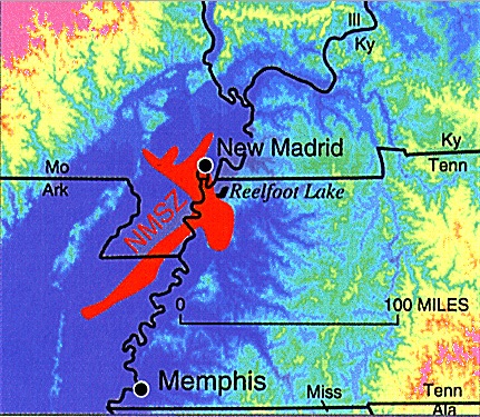
This image shows the NMSZ in a regional context:
This is extremely good info, if I may say so.
Having said that, let us never forget, that although logic and what we call Occam's Razor, really, once studied, begin to obfuscate, not enlarge upon a particular thought pattern and analysis.
We are on a conspiracy website, where we pride ourselves for intellectual dissemination. But often, the rules of logic we use to disseminate, actually may provide the obfuscation we wish to avoid, for much, over the years, has been introduced to distract and put us off course. .....
It truly is NOT logical to think that the simplest explanation is true. And it so no more so displayed as it is here, geologicallly. The world, land mass, is inextricably linked. A movement is one place, no matter how minute, will be a causitive factor elsewhere.
That is the way connectedness works.
As you can see, the New Madrid Seismic Zone is quite far north of the are in which the sinkhole has developed. Now, that is not to say that Louisiana would be unaffected if this fault zone were to rupture in a big way once more, it most certainly would. I just don't see how the sinkhole could have any appreciable affect on the fault zone.
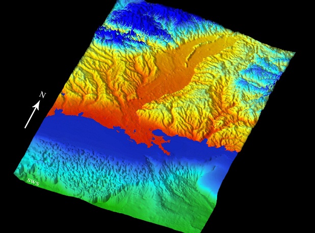
This image shows a 3d representation of the underlying rock strata with a bit of vertical exaggeration:
This is the Mississippi River Embayment, in which the Old Man River runs and has, as been mentioned, changed courses several times.
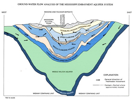
The following image is a cross section of a typical section of the embayment:
You can clearly see the several layers of aquifer and sediments that make up the river plain. It also shows the direction of the flow of water through the system, which may play into some of the unseen forces acting upon the sinkhole.
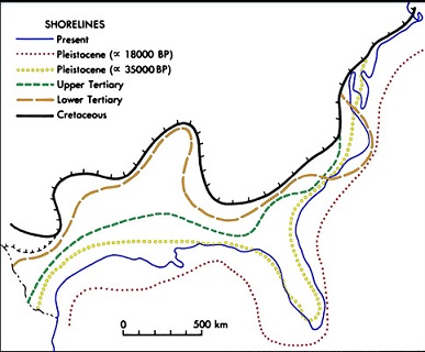
And I though this image which shows historic shorelines to be very interesting:
As you can see, the prior shorelines were many many miles further out in the more recent past and then also many many miles further in in the more distant past. Really gives you something to consider.
All above-referenced images taken from The Mississippi Embayment The Quaternary Canvas
Not directly related, but of interest i thought is this image:
I don't remember exactly where it is from, it's in my uploads section. A bit of googling would turn it up at some petroleum database, I am certain.
Anyway, if you notice the number of producing wells just off the shore and think about the effect removing all those millions (billions?) of gallons of crude oil would have on all of the layers above it boggles the mind.
All of the upper layers continue to push downward, and the entire Mississippi River Valley is not much more than one huge sediment glacier that is slowly flowing into the Gulf of Mexico. Something's going to give at some point, and when it does I hope that people are as safe as can be.
Originally posted by CajunBoy
reply to post by happykat39
My apologies happy. But yes, I do agree this is an event that will last for years. We have to many broken pieces we do not have the technology to fix. Best thing to do is let it play out.
Not a problem CajunBoy. Being an Alpha Nerd I sometimes tend to explain things to death thus further muddying the waters so to speak. I have found that some of the people who seem to disagree with me simply haven't read my post carefully enough. I just ran into a similar problem on the Racetrack Playa thread where no matter how carefully I tried to explain something one or two other posters just didn't get it and accused me of trying to change the laws of physics.I actually tried to explain my point in several posts in different ways but they either didn't get it or didn't want to get it, so I just gave up on them.
reply to post by tetra50
This is extremely good info, if I may say so.
Having said that, let us never forget, that although logic and what we call Occam's Razor, really, once studied, begin to obfuscate, not enlarge upon a particular thought pattern and analysis.
We are on a conspiracy website, where we pride ourselves for intellectual dissemination. But often, the rules of logic we use to disseminate, actually may provide the obfuscation we wish to avoid, for much, over the years, has been introduced to distract and put us off course. .....
It truly is NOT logical to think that the simplest explanation is true. And it so no more so displayed as it is here, geologicallly. The world, land mass, is inextricably linked. A movement is one place, no matter how minute, will be a causitive factor elsewhere.
That is the way connectedness works.
Just wanted to highlight what I contributed, as with all the bells and whistles, reading back through, it seemed to become seamless, which would be fine, but I wouldn't want what I had to say as to the above members' contribution to become lost....
You all have been busy. Many things written that I want to respond to.
So, Occam's Razor- the simplest is the most correct. So if we boil it down... We need to ask, why have people been evacuated for months? Why? My opinion is that they are concerned about what is going to come out of this hole. I feel officials were expecting the 'burp' & I think they are anticipating something else. If they feared a quick land give way them they would close the highway and enforce the evacuation. The natural gas lines are monitored and secure to make sure they are safe due to shifting. So why the evacuation???
IMO, No I do not believe we are seeing an event that will mirror Lake Peigneur in end results. I truly believe that this salt dome has been compromised. I believe the structural integrity of the dome is unstable, I believe this due to the bubbling over a large area. Had the bubbling all been in and around the sinkhole's immediate area, I would have felt confident that a fisherman's paradise was being born. I believe that we basically have a fracking event.
"Due to the similarities of there being water flow through the salt, rapidly at Lake Peigneur and ever so slowly at Bayou Corne, are we watching a large scale Lake Peigneur type disaster playing out over a vastly longer time scale at Bayou Corne?
So, Occam's Razor- the simplest is the most correct. So if we boil it down... We need to ask, why have people been evacuated for months? Why? My opinion is that they are concerned about what is going to come out of this hole. I feel officials were expecting the 'burp' & I think they are anticipating something else. If they feared a quick land give way them they would close the highway and enforce the evacuation. The natural gas lines are monitored and secure to make sure they are safe due to shifting. So why the evacuation???
edit on 7-12-2012 by AuntB because: (no reason
given)
reply to post by AuntB
The official line is because they are afraid of methane buildup under the houses and the potential for an explosion, or chain of explosions, if that does happen. But there are simple ways to prevent that like vent fans or, since methane is lighter than air, putting in un-powered vents to allow it to rise away from the houses.
But due to recent hedging, hemming and hawing on the part of the state agencies and Texas Brine, I believe you are right and they are hiding something much more dangerous than simple methane bubbling and sinkhole burping. Plus they are now in a serious "covering their a$$et$" and finger pointing contest. So yes, I think they are aware of something majorly more costly and dangerous than they have let the public know yet.
The natural gas lines are monitored and secure to make sure they are safe due to shifting. So why the evacuation???
The official line is because they are afraid of methane buildup under the houses and the potential for an explosion, or chain of explosions, if that does happen. But there are simple ways to prevent that like vent fans or, since methane is lighter than air, putting in un-powered vents to allow it to rise away from the houses.
But due to recent hedging, hemming and hawing on the part of the state agencies and Texas Brine, I believe you are right and they are hiding something much more dangerous than simple methane bubbling and sinkhole burping. Plus they are now in a serious "covering their a$$et$" and finger pointing contest. So yes, I think they are aware of something majorly more costly and dangerous than they have let the public know yet.
edit on
7-12-2012 by happykat39 because: clarified a point
Originally posted by happykat39
But due to recent hedging, hemming and hawing on the part of the state agencies and Texas Brine, I believe you are right and they are hiding something much more dangerous than simple methane bubbling and sinkhole burping.edit on 7-12-2012 by happykat39 because: correction
I interpret it differently, to be honest. I actually think the silence is based on the fact that they simply do not know, which they could never publicly admit (although it may win them back some brownie points with the general public if they simply came clean).
I honestly believe that they are in unchartered territory now and are not confident about making any definitive declarations.
reply to post by Flavian
Yes, that is a viable explanation too. Some officials have already stated that they are in uncharted territory with this sinkhole and have never had to deal with anything like it before. And maybe we are both right. The two are not mutually exclusive after all. In other words they could know something and be hiding it and still not know for sure what the future of this disaster will bring in the end.
Yes, that is a viable explanation too. Some officials have already stated that they are in uncharted territory with this sinkhole and have never had to deal with anything like it before. And maybe we are both right. The two are not mutually exclusive after all. In other words they could know something and be hiding it and still not know for sure what the future of this disaster will bring in the end.
reply to post by happykat39
I actually think that is pretty likely - they suspect something but because they haven't been in this position before they are unsure whether they should declare what that "something" is - in case they are totally wrong.
I have to be honest though. When this story first broke, i thought it was interesting and worth looking at but that it was simply another sink hole story. Albeit a man induced one (rather than weather or natural). Now though, this story seems to get murkier and potentially much worse on almost a day by day basis.
reply to post by happykat39
I like when people admit they are in uncharted territory. Many people are the opposite, they use irrelevant evidence to explain something. There is much that we don't know because we have not experienced it, to deny something exists because there is no evidence or known reasoning is not real science.
I like when people admit they are in uncharted territory. Many people are the opposite, they use irrelevant evidence to explain something. There is much that we don't know because we have not experienced it, to deny something exists because there is no evidence or known reasoning is not real science.
edit on 7-12-2012 by rickymouse because: (no reason given)
reply to post by Anmarie96
They had like 3 helicopters and 2 flyovers all together today.
Also being from Louisiana, when our government is silent, that is when you need to worry. I really don't believe it is because they are not sure what is going to happen. Hell, they blocked Senator Landruie from looking into this.
They had like 3 helicopters and 2 flyovers all together today.
Also being from Louisiana, when our government is silent, that is when you need to worry. I really don't believe it is because they are not sure what is going to happen. Hell, they blocked Senator Landruie from looking into this.
Well shut down at LA sink hole; H2S gas
discovered. (Again.)
Also,The Advocate had a brief description of the sinkhole. I'd never heard this summation. At least they have a hypothesis for now.
Thanks for posting the latest flyover video. It is amazing how big this thing has become!
OEP and DNR, along with Texas-Brine tested the flow line in the cavern again Friday to see if the gas is present; that is when the low levels of Hydrogen Sulfide was discovered. Because the gas was detected, the cavern cannot be pluggedand the gas will have to be removed as it flows. (Emphasis added.).
Also,The Advocate had a brief description of the sinkhole. I'd never heard this summation. At least they have a hypothesis for now.
The cavern failure, scientists think, allowed 3.3 million cubic yards of earth from outside the dome to enter the cavern previously hollowed out from the salt, leaving a collapse zone of disturbed earth alongside the dome and beneath the 8-acre sinkhole. A shallower overhanging section of salt on the edge of the salt dome also may have collapsed along with the salt cavern wall deeper underground.
Thanks for posting the latest flyover video. It is amazing how big this thing has become!
new topics
-
University student disciplined after saying veganism is wrong and gender fluidity is stupid
Education and Media: 43 minutes ago -
Geddy Lee in Conversation with Alex Lifeson - My Effin’ Life
People: 1 hours ago -
God lived as a Devil Dog.
Short Stories: 2 hours ago -
Police clash with St George’s Day protesters at central London rally
Social Issues and Civil Unrest: 3 hours ago -
TLDR post about ATS and why I love it and hope we all stay together somewhere
General Chit Chat: 4 hours ago -
Hate makes for strange bedfellows
US Political Madness: 6 hours ago -
Who guards the guards
US Political Madness: 9 hours ago -
Has Tesla manipulated data logs to cover up auto pilot crash?
Automotive Discussion: 11 hours ago
top topics
-
Hate makes for strange bedfellows
US Political Madness: 6 hours ago, 14 flags -
Who guards the guards
US Political Madness: 9 hours ago, 13 flags -
whistleblower Captain Bill Uhouse on the Kingman UFO recovery
Aliens and UFOs: 16 hours ago, 11 flags -
Police clash with St George’s Day protesters at central London rally
Social Issues and Civil Unrest: 3 hours ago, 7 flags -
TLDR post about ATS and why I love it and hope we all stay together somewhere
General Chit Chat: 4 hours ago, 5 flags -
University student disciplined after saying veganism is wrong and gender fluidity is stupid
Education and Media: 43 minutes ago, 3 flags -
Has Tesla manipulated data logs to cover up auto pilot crash?
Automotive Discussion: 11 hours ago, 2 flags -
God lived as a Devil Dog.
Short Stories: 2 hours ago, 2 flags -
Geddy Lee in Conversation with Alex Lifeson - My Effin’ Life
People: 1 hours ago, 2 flags
active topics
-
Candidate TRUMP Now Has Crazy Judge JUAN MERCHAN After Him - The Stormy Daniels Hush-Money Case.
Political Conspiracies • 731 • : Threadbarer -
"We're All Hamas" Heard at Columbia University Protests
Social Issues and Civil Unrest • 248 • : FlyersFan -
University student disciplined after saying veganism is wrong and gender fluidity is stupid
Education and Media • 4 • : chiefsmom -
Police clash with St George’s Day protesters at central London rally
Social Issues and Civil Unrest • 34 • : Freeborn -
Europe declares war on Russia?
World War Three • 64 • : Consvoli -
Thousands Of Young Ukrainian Men Trying To Flee The Country To Avoid Conscription And The War
Other Current Events • 118 • : Consvoli -
-@TH3WH17ERABB17- -Q- ---TIME TO SHOW THE WORLD--- -Part- --44--
Dissecting Disinformation • 626 • : cherokeetroy -
The Superstition of Full Moons Filling Hospitals Turns Out To Be True!
Medical Issues & Conspiracies • 19 • : FloridaManMatty -
Iranian Regime Escalates Hiijab Mandate Through Sexual Violence and Beatings of Women
Mainstream News • 166 • : purplemer -
They Killed Dr. Who for Good
Rant • 67 • : grey580