It looks like you're using an Ad Blocker.
Please white-list or disable AboveTopSecret.com in your ad-blocking tool.
Thank you.
Some features of ATS will be disabled while you continue to use an ad-blocker.

Tremors felt 45 miles away from Bayou Corne Sinkhole!
page: 30share:
reply to post by AuntB
I have spend a huge amount of time this afternoon trying to get and exact latitude and longitude of this sink hole but it is my contention that the seismos installed are NOT to monitor the sink-hole but to monitor the salt dome, over which they are installed.
I don't think the cultural noise is being picked up any more easily than at other seismos installed near roads, railways etc but the shaking of the ground may be increased because of the water.
A seism is the word I think you are looking for as that applies to any shaking of the ground.
Okay Puterman- here's a question. We have the 'cultural' readings that are showing up on the monitors. The traffic, drills and machines all seem to show up and I accept that. I recall prior to the sinkhole opening up, I read a report of a lady originally from CA saying that she was feeling earthquakes. The area is like Jello (IMO), could this be the reason things like cultural noise being picked up so easily? They don't seem to be earthquakes but they are. So now my question.... what is the correct term (word)?
I have spend a huge amount of time this afternoon trying to get and exact latitude and longitude of this sink hole but it is my contention that the seismos installed are NOT to monitor the sink-hole but to monitor the salt dome, over which they are installed.
I don't think the cultural noise is being picked up any more easily than at other seismos installed near roads, railways etc but the shaking of the ground may be increased because of the water.
A seism is the word I think you are looking for as that applies to any shaking of the ground.

I posted this pic a month back of a drilling rig that just showed up 2 miles from the sinkhole. They say they have had this planned out long before the sinkhole hole. I do believe the drilling may be causing more harm seismically along with destabilization around this area. What you think?
reply to post by PuterMan
I had thought it just might be more than a little unsafe to be out on that sinkhole for the cleanup. Well, this caption under the picture in the article you linked to confirms that.
They couldn't pay me enough to go out on old El Burpo in a boat. What if a really big gas pocket burped up under them, they would probably never find the bodies.
I had thought it just might be more than a little unsafe to be out on that sinkhole for the cleanup. Well, this caption under the picture in the article you linked to confirms that.
A 400-foot deep sinkhole in Louisiana is expanding and today swallowed the boat of two cleanup workers who had to be rescued from the hole. Officials are still fearful of the possibility of explosions from nearby gas-filled caverns.
They couldn't pay me enough to go out on old El Burpo in a boat. What if a really big gas pocket burped up under them, they would probably never find the bodies.
Keep an eye on seismo LA09, many residents been talking about that one and the readings it has been picking up. The last 48 hours have been weird.
Odor has been getting stronger and stronger.
Originally posted by CajunBoy
Keep an eye on seismo LA09, many residents been talking about that one and the readings it has been picking up. The last 48 hours have been weird. Odor has been getting stronger and stronger.
I lost the link to those seismometers. Could you repost it please?
The amount of disinformation about, and error, is astounding.
EN ENews
DOWN AT THE LOUISIANA SINKHOLE
Elsewhere, as I commented here it is 11:30 am
If the earth moved as it was put, then the seismos should show it but was it 4 minutes, 4 hours and morning or evening?
I want to try and find this 'activity' they apparently monitored but it is difficult without accurate information.
Official: Earth moved under giant sinkhole for 4 minutes
EN ENews
A “Burp” occurred and sent oil and debris to the surface after a four hour long seismic event.
An event occurred at the sinkhole around 11:30 pm today which is being considered as a “burp”.
DOWN AT THE LOUISIANA SINKHOLE
Elsewhere, as I commented here it is 11:30 am
If the earth moved as it was put, then the seismos should show it but was it 4 minutes, 4 hours and morning or evening?
I want to try and find this 'activity' they apparently monitored but it is difficult without accurate information.
reply to post by happykat39
The IRIS versions are in my signature.
I am afraid I don't use the others.
The IRIS versions are in my signature.
I am afraid I don't use the others.
reply to post by happykat39
I just clicked Puterman's Bayou Corne link and all the siesmos are there. Also here this lists all the temp monitors.
I just clicked Puterman's Bayou Corne link and all the siesmos are there. Also here this lists all the temp monitors.
Originally posted by AuntB
reply to post by happykat39
I just clicked Puterman's Bayou Corne link and all the siesmos are there. Also here this lists all the temp monitors.
That is the one i was looking for. thank you.
A lot of activity seems to be going on right now. Enough that all seismos are picking it up.
I am still thinking about this statement. I wish we had details on how long the water was 6 inches lower. Is this meaning that all 8 acres of water dropped 6 inches? That's a good amount of water. Not much research out there on sinkholes burping but I haven't given up looking.
Boudreaux said before the sinkhole disgorged the material, the water level dropped by about 6 inches and then returned to its original level.
reply to post by AuntB
If I heard correctly, it was in less than an hour that the water dropped till the time it came back up.
If I heard correctly, it was in less than an hour that the water dropped till the time it came back up.
Work has begun on putting a geophone at 450ft. It will be ready tomorrow!
reply to post by CajunBoy
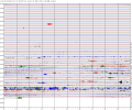
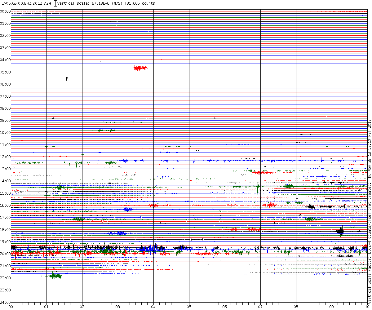
There are only 2 seismos picking up anything out of the ordinary LA03 and LA06. Both have interference but at different times. I am listening to LA06 as I type this and it is quite clearly some sort of radio interference.
Have a listen yourselves 132Kb file covers around 1 hour from around 1930 UTC.
See the bottom of this seismogram
Looking at them on CERI the broken or flat lines are all the same interference.
There are only 2 seismos picking up anything out of the ordinary LA03 and LA06. Both have interference but at different times. I am listening to LA06 as I type this and it is quite clearly some sort of radio interference.
Have a listen yourselves 132Kb file covers around 1 hour from around 1930 UTC.
edit on 29/11/2012 by PuterMan because: to fix a tag
See the bottom of this seismogram
edit on 29/11/2012 by PuterMan because: (no reason given)
Looking at them on CERI the broken or flat lines are all the same interference.
edit on 29/11/2012 by PuterMan because: (no reason given)
They dropped the amount of meetings again! Next one won't be till December 18th... Slowly but surely they are not caring anymore
reply to post by CajunBoy
I am assuming you are meaning in the sinkhole??
Bet we won't get to see that data..................glug glug glug...........
Work has begun on putting a geophone at 450ft. It will be ready tomorrow!
I am assuming you are meaning in the sinkhole??
Bet we won't get to see that data..................glug glug glug...........
Originally posted by PuterMan
reply to post by AuntB
Snip
I have spend a huge amount of time this afternoon trying to get and exact latitude and longitude of this sink hole but it is my contention that the seismos installed are NOT to monitor the sink-hole but to monitor the salt dome, over which they are installed.
Snip
30° 0'38.23"N
91° 8'33.02"W
Within a couple of seconds.
Regards NORM:
Oil and gas production and processing operations sometimes cause naturally occurring radioactive materials (NORM) to accumulate at elevated concentrations in by-product waste streams
The EPA has the following information:
Much of the petroleum in the earth's crust was created at the site of ancients seas by the decay of sea life. As a result, petroleum deposits often occur in aquifers containing brine (salt water). Radionuclides, along with other minerals that are dissolved in the brine, precipitate (separate and settle) out forming various wastes at the surface:
mineral scales inside pipes
sludges
contaminated equipment or components
produced waters
Because the extraction process concentrates the naturally occurring radionuclides and exposes them to the surface environment and human contact, these wastes are classified as TENORM.
As you can see, there are several vectors in which these by products can be introduced into the environment.
The amounts present vary greatly:
Because radium levels in the soil and rocks vary greatly, so do their concentrations in scales and sludges. Radiation levels may vary from background soil levels to as high as several hundred nanoCuries per gram.
While the low end of the scale is nominal and probably not even worth much consideration, the levels at the higher end are problematic.
These byproducts occur in many production sites, some in greater concentrations than others:
An estimated 30 percent of domestic oil and gas wells produce some TENORM (McA88). In surveys of production wells in 13 states, the percent reporting high concentrations of radionuclides in the wells ranged from 90 percent in Mississippi to none or only a few in Colorado, South Dakota, and Wyoming (McA88). However, 20 to 100 percent of the facilities in every state reported some TENORM in heater/treaters.
Nothing is said about the Louisiana levels of these byproducts, CanjuBoy may be able to locate this information as he is local to the area.
What problems do these materials represent?
Because of concerns that some pipes may have contaminated the surrounding environment, radiological surveys were conducted by EPA's Eastern Environmental Radiation Facility. These surveys showed that some equipment and disposal locations exhibited external radiation levels above 2 mR/hr and radium-226 soil contamination above 1,000 pCi/g. Some contamination had also washed into a nearby pond and drainage ditch at one site, as well as into an agricultural field with subsequent uptake of radium by vegetation.
As is the case in many industries, the contamination of the environment is at greater risk levels from past production as the dangers were not sufficiently accounted for.
The problem s not external exposure, but rather the possibility that these materials may be introduced into the environment and taken up by various biological processes.
Radiation exposure is subject to the inverse Square Law:
As one of the fields which obey the general inverse square law, a point radiation source can be characterized by the relationship below whether you are talking about Roentgens , rads, or rems . All measures of exposure will drop off by inverse square law
The thing that makes internal exposure a concern is that the law works in both directions so that any internally lodged particle will be in direct contact with living tissue, resulting in maximum damage.
Different isotopes are chemically similar to other minerals that the body uses in it's normal biological processes. Strontium, for example is similar to calcium and will lodge within bone, elevating the risk of bone cancer and leukemia.
reply to post by jadedANDcynical
Thank you Clever clogs I must have been putting in the wrong thing as I just could not find it. It did take me to that sink hole blog however which was quite interesting.
Something I find very troubling about these seismos. LA03 and LA09 are pretty much on top of each other (unfortunately 2 decimal lat/lon put them in a grid). There will be minor differences in the amplitude etc as there always are between channels on the same instrument. Why two in virtually the same place? I don't get it.
The other thing is that signals on one seismo don't show on another. Here is LA03 and LA06 from today - just a part of it.
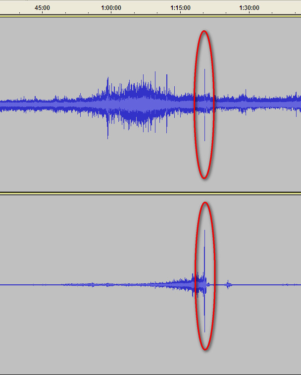
Looking at that much closer in there appears to be some similarity in the signal - bearing in mind this is the spike I am looking at. This spike is the ONLY part of the whole section I downloaded that matches on to the other and I find that very strange. LA03 is 0.26km from the sink-hole using the co-ordinates you supplied and LA06 is 1.21 km.
In close up those two traces look like this.
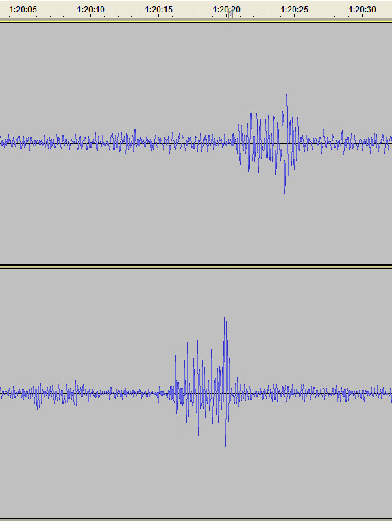
The mark on the upper one is not part of the signal, it just the cursor position. The difference between those two is ~4 seconds therefore if that was a seismic event the source would have to be at the minimum 12km further away from the source for the later signal, and more likely 32km, BUT if that signal is being produced by an airborne sound and here I am using the memory (not good!) sound travels ~750 ft per second (at msl).
This is approximately 0.2286 km per second and that would make the second seismo 4 x 0.2286 km further away which is 0.914 kilometres. The difference in distance from the sink hole is 0.95 km given that these are not very accurately located. That seems to me to make this signal airborne rather than a seism. (And yes loud sounds do show on a seismogram - e.g. sonic booms etc)
So possibly what we are seeing is sounds from the sink hole and not seismic signals which relieves me greatly as I have not been able to find anything that is positively seismic.
I am away to the Land of Nod but I will take up my investigations tomorrow in a renewed light.
ETA LA06 is the upper signal on both those. Just spotted that I had not mentioned that.
Within a couple of seconds.
Thank you Clever clogs I must have been putting in the wrong thing as I just could not find it. It did take me to that sink hole blog however which was quite interesting.
Something I find very troubling about these seismos. LA03 and LA09 are pretty much on top of each other (unfortunately 2 decimal lat/lon put them in a grid). There will be minor differences in the amplitude etc as there always are between channels on the same instrument. Why two in virtually the same place? I don't get it.
The other thing is that signals on one seismo don't show on another. Here is LA03 and LA06 from today - just a part of it.
Looking at that much closer in there appears to be some similarity in the signal - bearing in mind this is the spike I am looking at. This spike is the ONLY part of the whole section I downloaded that matches on to the other and I find that very strange. LA03 is 0.26km from the sink-hole using the co-ordinates you supplied and LA06 is 1.21 km.
In close up those two traces look like this.
The mark on the upper one is not part of the signal, it just the cursor position. The difference between those two is ~4 seconds therefore if that was a seismic event the source would have to be at the minimum 12km further away from the source for the later signal, and more likely 32km, BUT if that signal is being produced by an airborne sound and here I am using the memory (not good!) sound travels ~750 ft per second (at msl).
This is approximately 0.2286 km per second and that would make the second seismo 4 x 0.2286 km further away which is 0.914 kilometres. The difference in distance from the sink hole is 0.95 km given that these are not very accurately located. That seems to me to make this signal airborne rather than a seism. (And yes loud sounds do show on a seismogram - e.g. sonic booms etc)
So possibly what we are seeing is sounds from the sink hole and not seismic signals which relieves me greatly as I have not been able to find anything that is positively seismic.
I am away to the Land of Nod but I will take up my investigations tomorrow in a renewed light.
ETA LA06 is the upper signal on both those. Just spotted that I had not mentioned that.
edit on 29/11/2012 by PuterMan because: Changed thumbnail to picture
All right this is from Idahopicker three new major events pertaining to the sinkhole today: 1) LEAN (a Lousianna evironmental group) has found
hydrocarbons in the blood of individuals around the area of the sink hole. 2) LA08 the monitor over the butane cavern experienced major activity this
morning 3) Cholride is now migrating from the sinkhole into the mississippi river and the aquafir. here is the link to the video..
www.youtube.com...
www.youtube.com...
Originally posted by BrieBird
All right this is from Idahopicker three new major events pertaining to the sinkhole today: 1) LEAN (a Lousianna evironmental group) has found hydrocarbons in the blood of individuals around the area of the sink hole.
When I think about it I would be surprised if they didn't find a bunch of nasty chemicals in the blood of the subjects. Especially considering all the toxic substances that make up COREXIT which was used by the ton in the gulf and the components of the diesel fuel, crude oil and other things coming up in the gulf and around the sinkhole.
2) LA08 the monitor over the butane cavern experienced major activity this morning
That monitor being at the butane storage site and looking like it does for as long as it does, if not from the activities related to emptying it, is seriously disturbing.
3) Cholride is now migrating from the sinkhole into the mississippi river and the aquafir.
I wonder just which chloride they are referring to? Chloride is a term used for a chemical compound that contains chlorine with other elements. For instance potassium chloride is used as a sodium free salt substitute, ammonium chloride is used in dry cell batteries, barium chloride gives fireworks a green color, calcium chloride is used in place of rock salt to melt ice and snow and finally the one we are all familiar with and which is in the salt dome in plentiful supply, sodium chloride or as we know it in common terms, table salt.
So having chloride leak into the river and the aquifer, while not a good thing, is not surprising either. What is bad about this is not that chloride is leaking but rather that anything at all that requires water flow to carry it is leaking into the river and aquifer. That indicates a breach of the salt cavern that is allowing water to flow THROUGH it. Water flowing through salt is a really bad thing because it indicates that the erosion of the already unstable salt dome is continuing in such a way that it will most likely lead to further failures and collapses.
And so the super slow train wreck continues to get worse instead of better.
edit on 29-11-2012 by happykat39 because: clarified a point
new topics
-
Electrical tricks for saving money
Education and Media: 1 hours ago -
VP's Secret Service agent brawls with other agents at Andrews
Mainstream News: 2 hours ago -
Sunak spinning the sickness figures
Other Current Events: 3 hours ago -
Nearly 70% Of Americans Want Talks To End War In Ukraine
Political Issues: 3 hours ago -
Late Night with the Devil - a really good unusual modern horror film.
Movies: 5 hours ago -
Cats Used as Live Bait to Train Ferocious Pitbulls in Illegal NYC Dogfighting
Social Issues and Civil Unrest: 6 hours ago -
The Good News According to Jesus - Episode 1
Religion, Faith, And Theology: 8 hours ago -
HORRIBLE !! Russian Soldier Drinking Own Urine To Survive In Battle
World War Three: 10 hours ago
top topics
-
SETI chief says US has no evidence for alien technology. 'And we never have'
Aliens and UFOs: 17 hours ago, 8 flags -
Cats Used as Live Bait to Train Ferocious Pitbulls in Illegal NYC Dogfighting
Social Issues and Civil Unrest: 6 hours ago, 8 flags -
Florida man's trip overseas ends in shock over $143,000 T-Mobile phone bill
Social Issues and Civil Unrest: 13 hours ago, 8 flags -
VP's Secret Service agent brawls with other agents at Andrews
Mainstream News: 2 hours ago, 7 flags -
Former Labour minister Frank Field dies aged 81
People: 15 hours ago, 4 flags -
Bobiverse
Fantasy & Science Fiction: 13 hours ago, 3 flags -
HORRIBLE !! Russian Soldier Drinking Own Urine To Survive In Battle
World War Three: 10 hours ago, 3 flags -
Nearly 70% Of Americans Want Talks To End War In Ukraine
Political Issues: 3 hours ago, 3 flags -
Sunak spinning the sickness figures
Other Current Events: 3 hours ago, 3 flags -
Late Night with the Devil - a really good unusual modern horror film.
Movies: 5 hours ago, 2 flags
active topics
-
Cats Used as Live Bait to Train Ferocious Pitbulls in Illegal NYC Dogfighting
Social Issues and Civil Unrest • 13 • : Albone -
Spectrophilia - Women Who Have Had Affairs With Ghosts Say Spooks Are Better Lovers Than Real Men
Paranormal Studies • 31 • : charlyv -
HORRIBLE !! Russian Soldier Drinking Own Urine To Survive In Battle
World War Three • 29 • : doubledan717 -
-@TH3WH17ERABB17- -Q- ---TIME TO SHOW THE WORLD--- -Part- --44--
Dissecting Disinformation • 651 • : 777Vader -
VP's Secret Service agent brawls with other agents at Andrews
Mainstream News • 19 • : NoCorruptionAllowed -
VirginOfGrand says hello
Introductions • 5 • : burritocat -
The Reality of the Laser
Military Projects • 44 • : Zaphod58 -
SETI chief says US has no evidence for alien technology. 'And we never have'
Aliens and UFOs • 42 • : Boomer1947 -
NASA Researchers Discover a Parallel Universe That Runs Backwards through Time - Alongside Us
Space Exploration • 71 • : charlyv -
Sunak spinning the sickness figures
Other Current Events • 4 • : annonentity