It looks like you're using an Ad Blocker.
Please white-list or disable AboveTopSecret.com in your ad-blocking tool.
Thank you.
Some features of ATS will be disabled while you continue to use an ad-blocker.

Tremors felt 45 miles away from Bayou Corne Sinkhole!
page: 100share:
We all need to remember that the videos placed on Youtube and other sites often get removed, so saving on our local hard drive is the best method as
they can be reposted if necessary. For example, many of the ones showing the early days of Fukushima have now been removed and so links to these mean
that the information gets lost forever as soon as they are deleted (or asked to be removed) by the original owners. There are too many of these
missing videos to be a coincidence in my opinion.
I take it from the lack of new posts that all is quiet for now.
My thoughts and prayers are with everyone affected by this!
Ms. Nugget
My thoughts and prayers are with everyone affected by this!
Ms. Nugget
reply to post by qmantoo
I figured information was being quashed - what's going on down there? What happened to cajun boy?
I figured information was being quashed - what's going on down there? What happened to cajun boy?
Has this thread died? Anyone still about? I know this post does not contribute much at all, but it would be good if we can keep going and keep on top
of the situation. Particularly the community meetings, minor equakes/tremors, etc.
reply to post by qmantoo
I watch a couple of sites and get a couple of e-mail newsletters that would carry information if there were any to pass on. It seems that either there is not much happening or the companies and government agencies monitoring the area are effectively quashing any info before it goes public. As to CajunBoy, I am worried that something might have happened to him. I certainly hope it wasn't anything serious; especially "enemy action".
I watch a couple of sites and get a couple of e-mail newsletters that would carry information if there were any to pass on. It seems that either there is not much happening or the companies and government agencies monitoring the area are effectively quashing any info before it goes public. As to CajunBoy, I am worried that something might have happened to him. I certainly hope it wasn't anything serious; especially "enemy action".
Our Cajun Boy went back to school to save the environment. I am sure he is studying hard and now hanging out with the intellectual crowd.
The sinkhole has been having strange movements off and on but no real news is coming out of the bayou. I see they are having meetings and such but no reports of what is truly happening. I think they were working on fixing the berm and today the helicorders on the CERI page have been kind of quiet.
The sinkhole did make Fox news on the 17th. Louisiana 25-acre sinkhole brings mini-earthquakes, explosion fears Though the following day Texas Brine had their 2 cents added to the article.
Thanks for the info guys. If anything comes up, let us all know. :-) I know, this is a one-liner!
I read this article on the sinkhole this morning and thought it was worth sharing.
theextinctionprotocol.wordpress.com... rs-of-mini-quakes-explosions-to-be-monitored-for-decades/
Nugget
theextinctionprotocol.wordpress.com... rs-of-mini-quakes-explosions-to-be-monitored-for-decades/
Nugget
assumptionla.wordpress.com...
Texas Brine advised that the tagging of Cavern 3 is at 3,869′ which is 189′ higher than the tagging performed a little more than two weeks ago. As information becomes available, it will be shared here.
The monitors have been active. So I will keep watching.
A bit of new info on the sinkhole, courtesy of NASA.....
Surprise: Louisiana sinkhole slid sideways before Collapsing
Sometimes eyes in the skies are our friends!
Surprise: Louisiana sinkhole slid sideways before Collapsing
Sometimes eyes in the skies are our friends!
ongoing subsidence of the center portion of the Southern Berm. We continue to monitor any changes that may occur and will update accordingly.
December 31, 2013
12:55 p.m. Statement from Texas Brine, re: South Berm
Today, in discussion with and approval from DNR and APOEP, Texas Brine
has received permission to proceed with temporary repair work to the south berm in order to raise the height of the berm to protect against any immediate potential for overtopping due to subsidence. As part of this discussion, TBC has agreed to move forward with planning and submission of Emergency Use Authorizations and engineering designs for the installation
of a new southern containment structure. TBC will then proceed with the installation of this new southern containment system once the requisite permission and approvals have been received from DNR, DEQ, and APOEP.
The current south berm and containment system is still intact and
providing a continuous barrier between the waters inside and out of the sinkhole, but in an abundance of caution and due to recent seismic and
settlement activity the decision has been made to move forward with these new plans in order to ensure the long term containment of the sinkhole and any contaminants. TBC will also install two additional inclinometers
south of the current southern berm to provide additional data and early
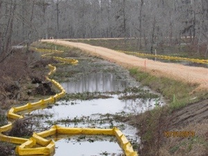
warning of any movement due to subsidence in this area. Multiple layers of boom are also in place as redundant systems to provide protection against floating contaminants should any overtopping take place. Water quality testing is continuing to take place and consistently shows that the surface water quality within the containment berm is virtually the same as waters outside the containment berm.
Assumption Parish
It continues to get lower also from an older post.
December 26, 2013
2:50 p.m. Update
Texas Brine advised that the tagging of Cavern 3 is at 4,076′ which is 66′ lower than the tagging performed two weeks ago. As information becomes available, it will be shared here.
edit on 31-12-2013 by lurksoften because: (no reason given)
Some detailed info as of dec 6th on what they been up to.
GOHSEP RESPONSE
- Monitored cracks in south berm daily during berm inspections
- Water transfer pumps on southwest berm continued to operate Tuesday – Thursday (12/3 – 12/5). Since November 5, a total of 43,092,000 gallons have been
transferred into the sinkhole from the surrounding swamp.
- Repair work on the south berm crack continued Tuesday and Wednesday (12/3 – 12/4). The crack was filled with grout and covered with clay, geotextile fabric, and
limestone
edit on 31-12-2013 by lurksoften because: (no reason given)
reply to post by lurksoften
Assumption Parish
January 2, 2014
12 Noon Update from the Office of Conservation
Bayou Corne/Grand Bayou Response Activity
Thursday, Jan. 2 work-
Sinkhole Activity Code 3 – indicating no work is allowed directly on sinkhole or within containment berms. Seismic monitoring indicates further increase in levels of subsurface activity near sinkhole/Oxy 3 – state and parish will continue to closely observe seismic activity to advise of any sudden changes.
Containment Berm/Roads/Sinkhole
- Repairing and building up low areas on southern containment berm
- Re-stocking sand and gravel supplies for berm maintenance/repair
Assumption Parish
Just like before my twin brother's death, 9/11 and Fukushima, this has been making my nights restless. I don't do this often, but I'll put it out
there... Watch the Gulf, I can't shake the feeling something is coming soon. My feeling is before March 1st. Being wrong would make me very happy,
indeed.
CornShucker
Just like before my twin brother's death, 9/11 and Fukushima, this has been making my nights restless. I don't do this often, but I'll put it out there... Watch the Gulf, I can't shake the feeling something is coming soon. My feeling is before March 1st. Being wrong would make me very happy, indeed.
The gulf has slid off the radar but there are still some MAJOR concerns about it. It is somewhat connected to the Bayou Corne sinkhole and the New Madrid fault system. The real problem with the gulf is that there is a lot of pressure buildup and hot tar seepage from under the sea bed in the gulf from the oil well failure that is still not completely sealed off.
One of the things that could happen is that the absolutely enormous amount of methane hydrate on the floor of the gulf could be released by even a minor disturbance if the water on the bottom warms up by just a few degrees. This could cause a tidal wave that could scour the gulf coast to a distance from a few miles to as much as a hundred miles inland. And as the methane mixes with air to an explosive concentration an explosion could be triggered that would rival a small nuke in power.
If any of the above happens it could trigger the New Madrid fault zone and cause major damage possibly as fart north as the southern tip of lake Michigan. That, if it happened, would also break up the salt dome that the Bayou Corne sinkhole is in.
reply to post by happykat39
You're #ing ridiculous. I have not seen fear mongering like this on ATS in a long time. Sure there is some truth there, warming of the sea floor could cause methane gas built up in the muck to be released, but it would not cause a tidal wave. Not even close, it would make the area smell really, really bad, but the methane is trapped in shale, below the "mud" on the sea floor, the water warming up will not release it. This is why fracking exists to free that exact gas, from that exact substrate.
Now, Hot tar? Bubbling? You realize the well is for crude oil right? And that they drilled a hole miles down, inserted a pipe, and the top of that pipe broke. where is this hot tar you speak?
Okay, now back to methane gas.
There is not enough gas in that sediment to cause a sudden explosion over open sea water. There is far too much air current, and the methane gas would rise and mix with the atmosphere so quickly it likely wouldn't even catch fire, minor explosion or something we could even begin to compare to "nuclear" yield explosions.
You should write a book, I bet it would out sell the bible with whacky claims like that.
reply to post by lurksoften
Thanks for keeping us updated, Lurksoften.
The microquakes seem to have finally come to halt after 2 weeks of non-stop cracking. The seismic code is back to "code 1".
There are 2 new videos. The 1st is a flyover from yesterday, the 7th, and the 2nd is from Sunday, showing more trees going in.
Thanks for keeping us updated, Lurksoften.
The microquakes seem to have finally come to halt after 2 weeks of non-stop cracking. The seismic code is back to "code 1".
There are 2 new videos. The 1st is a flyover from yesterday, the 7th, and the 2nd is from Sunday, showing more trees going in.
reply to post by Olivine
Thanks for posting these Olivine. It is amazing how this sinkhole just keeps going and the media is silent. The youtube videos don't allow
comments because I think this discourages people from sharing and talking about this.
Wonder what kind of information there going to be sharing.
Assumption Parish
January 13, 2014
10:45 a.m. Informational Meeting Scheduled, 01/14/14 @ 5:30 p.m.
An informational meeting will be held tomorrow at the Command Trailer in Bayou Corne at 5:30 p.m. An update of future activities, specifically the passive vent well program, will be given to residents. Texas Brine representatives will be on-site to present this information.
Sinkhole Activity Code 1 – indicating work is allowed on sinkhole and within containment berms. Seismic monitoring indicates continued low levels of subsurface activity near sinkhole/Oxy 3.
Air Monitoring/Sub-slab Sampling and Ventilation
- Conducting ventilation system inspections
ORW/CPT Wells
- De-pressurizing ORW 54 (north of La 70, west of Texas Brine facility) to change out wellhead
- Monitoring bubble site 56 (Bayou Corne, north of La 70)
- Removing water from ORWs 10 (west of containment berm) 22 (north of La 70, west of Texas Brine facility) and 39 (north of containment berm)
Containment Berm/Roads/Sinkhole
- Surveying north and south containment berms
- Surveying containment berm settlement plates
Assumption Parish
Did we ever get that 3D radar survey released? The one where the data was sent to independent analysts to review because they thought the Texas Brine
interpretation was flawed? If not, that was a good number of months ago and someone should be asking questions about it and where it is. If it has
been released, please can someone post a link again?
The Bayou Corne sinkhole is allegedly supposed to be somehow connected deep down with the Gulf and there are thoughts that possibly there is some kind of seepage from there to the salt dome and from there to the BC sinkhole area.
We dont know what effect all this has on the underlying structure of the area and the Earth may have zones which are related to each other which may be many miles apart, so one event in one place could be the cause of another event half-way around the world or closer. I think it just depends how these things pan out as to whether there is a major event or a minor one, however, if there is a major event, then it will affect many people in multiple ways and the feeling by some is that the pressure is building up for some kind of major event to happen soon.
I am pleased to see folks are still following this situation, and it would also be good to also have feedback from public meetings etc as this keeps the event in the publics mind. Heaven knows the guys who live in this area dont deserve to have their lives uprooted like this and we need to make sure that the people who are at fault and negligent get their due rewards.
reply to post by qmantoo
Gee, it's been a while, eh?
Qmantoo, I've never seen the EM mapping released. The most recent depth survey (3 page .pdf) is dated February 2014 and was released 5 March.
It seems like the seismicity has been very quiet at the sinkhole the past few months, but yesterday work was stopped because of "code 2" level tremors.
Remember how they were tagging the cavern depth every week?
Back in mid-February, the cavern had filled to within 6' of the top; at 3642' below the surface. The most recent tagging, reported on 17 March, found the cavern fill at 3995' below the surface--a drop of 351' over 2 weeks.
The situation is still far from stable, at depth....
Police Jury blog
Oh yeah, back in February, they found a new bubbling site on Grand Bayou.
This fiasco has been ongoing for almost 2 years...
Gee, it's been a while, eh?
Qmantoo, I've never seen the EM mapping released. The most recent depth survey (3 page .pdf) is dated February 2014 and was released 5 March.
It seems like the seismicity has been very quiet at the sinkhole the past few months, but yesterday work was stopped because of "code 2" level tremors.
Remember how they were tagging the cavern depth every week?
Back in mid-February, the cavern had filled to within 6' of the top; at 3642' below the surface. The most recent tagging, reported on 17 March, found the cavern fill at 3995' below the surface--a drop of 351' over 2 weeks.
The situation is still far from stable, at depth....
Police Jury blog
Oh yeah, back in February, they found a new bubbling site on Grand Bayou.
A new bubbling site has been discovered in Grand Bayou on LA-69, 1/4 mile north of the Gator Corner. A video of the site is accessible at: www.youtube.com...
This fiasco has been ongoing for almost 2 years...
new topics
-
USO 10 miles west of caladesi island, Clearwater beach Florida
Aliens and UFOs: 2 hours ago -
Abortions in first 12 weeks should be legalised in Germany, commission says
Medical Issues & Conspiracies: 11 hours ago -
Israel ufo shoot down drones?
Aliens and UFOs: 11 hours ago -
Tesla cutting 14,000 jobs
Global Meltdown: 11 hours ago -
On this Day in History, April 15, 1865, Abraham Lincoln Passed Away.
General Chit Chat: 11 hours ago
top topics
-
Anti-Israel Protesters in CHICAGO Chant 'Death to Israel and 'Death to America'
Social Issues and Civil Unrest: 14 hours ago, 15 flags -
Denver to Defund the Police 8.4 Million To Pay for Illegal Aliens
Social Issues and Civil Unrest: 16 hours ago, 14 flags -
Running Through Idiot Protestors Who Block The Road
Rant: 12 hours ago, 12 flags -
Fossils in Greece Suggest Human Ancestors Evolved in Europe, Not Africa
Origins and Creationism: 16 hours ago, 9 flags -
Report March 2024 - Underwater UFOs display capability that ‘jeopardizes US maritime security,’
Aliens and UFOs: 16 hours ago, 6 flags -
Tesla cutting 14,000 jobs
Global Meltdown: 11 hours ago, 6 flags -
Israel ufo shoot down drones?
Aliens and UFOs: 11 hours ago, 5 flags -
Abortions in first 12 weeks should be legalised in Germany, commission says
Medical Issues & Conspiracies: 11 hours ago, 5 flags -
USO 10 miles west of caladesi island, Clearwater beach Florida
Aliens and UFOs: 2 hours ago, 5 flags -
On this Day in History, April 15, 1865, Abraham Lincoln Passed Away.
General Chit Chat: 11 hours ago, 4 flags
active topics
-
Tesla cutting 14,000 jobs
Global Meltdown • 43 • : Vermilion -
USO 10 miles west of caladesi island, Clearwater beach Florida
Aliens and UFOs • 6 • : matafuchs -
-@TH3WH17ERABB17- -Q- ---TIME TO SHOW THE WORLD--- -Part- --44--
Dissecting Disinformation • 471 • : 777Vader -
Woke Leftist dems, hate Your Rights and the Country;
Political Issues • 62 • : ashisnotanidiot -
It has begun... Iran begins attack on Israel, launches tons of drones towards the country
World War Three • 625 • : Justoneman -
Candidate TRUMP Now Has Crazy Judge JUAN MERCHAN After Him - The Stormy Daniels Hush-Money Case.
Political Conspiracies • 187 • : Daughter2v2 -
Fossils in Greece Suggest Human Ancestors Evolved in Europe, Not Africa
Origins and Creationism • 45 • : whereislogic -
Gold and silver prices....woo hoo
History • 70 • : annonentity -
Negotiations and Diplomacy.
History • 9 • : NorthOS -
Abortions in first 12 weeks should be legalised in Germany, commission says
Medical Issues & Conspiracies • 7 • : Consvoli