It looks like you're using an Ad Blocker.
Please white-list or disable AboveTopSecret.com in your ad-blocking tool.
Thank you.
Some features of ATS will be disabled while you continue to use an ad-blocker.

Super-Typhoon Jelawat Projected To Hit Fukushima?
page: 13
share:
Just a heads up, via the CIMSS Tropical Cyclone site:
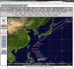
click thumb for larger screen capture
tropic.ssec.wisc.edu...#
Yikes. That's about all I can say, except to ask for comments and concerns.
TIWWA
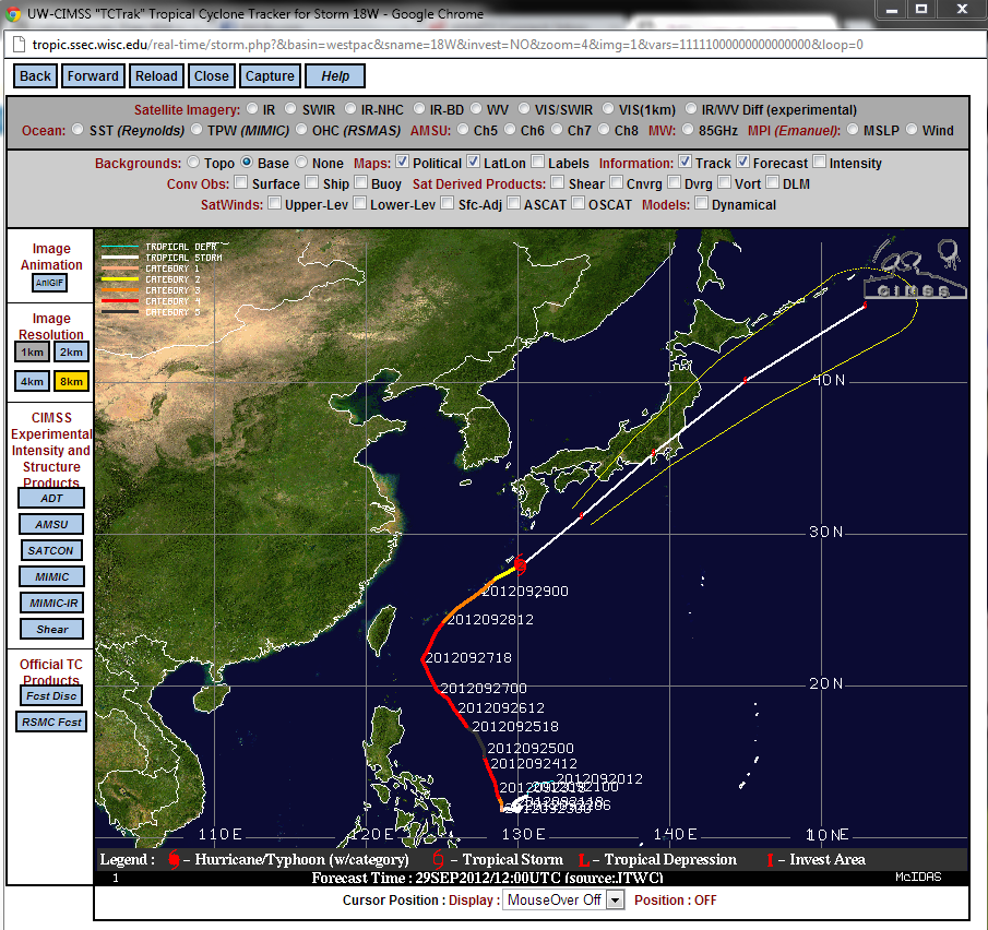
click thumb for larger screen capture
tropic.ssec.wisc.edu...#
Yikes. That's about all I can say, except to ask for comments and concerns.
TIWWA
edit on 9/29/2012 by this_is_who_we_are because: typo
If the weather report hasnt changed, I believe its to hit as a not so 'super' storm. But dangerous considering the storm surge
reply to post by GeneralMishka
Well, it will weaken over land, but it's still a concern I would imagine.
Well, it will weaken over land, but it's still a concern I would imagine.
Will we see another meltdown ?
Thats what matters, typhoon come and goes, radioactive stays
Thats what matters, typhoon come and goes, radioactive stays
reply to post by NullVoid
Well, I hope we won't see another meltdown. I'm just thinking of the tides and high winds whipping up and spreading whatever radioactive particles are still at the site. I mean, the site is still highly radioactive, is it not?
Well, I hope we won't see another meltdown. I'm just thinking of the tides and high winds whipping up and spreading whatever radioactive particles are still at the site. I mean, the site is still highly radioactive, is it not?
What makes this a "super typhoon"? I see a little 2 over it. Does that mean cat2? If so, well there isn't much super about that. I tried going
to the link but it doesn't work for me. Can someone fill me in on the strength of this thing?
reply to post by Under Water
There's a Wiki article here:
Typhoon Jelawat (2012)
en.wikipedia.org...(2012)
And it's short:
There's a Wiki article here:
Typhoon Jelawat (2012)
en.wikipedia.org...(2012)
And it's short:
Late on September 17, a tropical disturbance formed east of Guam. Early on September 20, the JMA upgraded the low-pressure area to a tropical depression, just after the JTWC issued a TCFA on the system. Eight hours later, the PAGASA also upgraded the system to a tropical depression named it Lawin, before the JTWC also upgraded it to a tropical depression. Late on the same day, the JMA upgraded the system to a tropical storm and named it Jelawat, so did the JTWC. Only a half of day later, the JMA upgraded Jelawat to a severe tropical storm on September 21. Early on September 23, both the JMA and the JTWC upgraded Jelawat to a typhoon as it started to undergo explosive intensification, from a category 1 typhoon, to a category 4 typhoon in 12 hours, as it developed a small eye. Early of September 25, as the system continued to strengthen, the JTWC upgraded the system to a category 5 super typhoon, as Jelawat developed an symmetrical, well defined eye at 50 kilometers wide, after a few eyewall replacement cycles. On September 26, the JTWC downgraded the system to a Category 4 super typhoon, and it soon started to undergo its fourth eye wall replacement cycle, which lasted 15 hours. The eye ended up at 70 kilometers across.
edit on 9/29/2012 by this_is_who_we_are because: wiki snippet
reply to post by Under Water
If you're referring to the link I posted in the OP, it works for me. I don't know what the problem might be on your end. Do you have cookies and Java enabled?
If you're referring to the link I posted in the OP, it works for me. I don't know what the problem might be on your end. Do you have cookies and Java enabled?
To OP:
The progression to Fukishima is liner.
Everyone knows that's not the way nature works.
Once over the sea and air currents on open sea, it can go many different ways.
Best China take precautions, it's coastal regions warned, people on standby to be evacated if necessary, so too emergency and medical assistances, and its vessels in the sea move to safer shores. So too Japan. No precious human lives need be lost.
edit on 29-9-2012 by SeekerofTruth101
because: (no reason given)
reply to post by SeekerofTruth101
Hence the question mark at the end of the title of the thread. I'm actually always saying to myself, as I watch The Weather Channel's various hurricane path projections, "It could go anywhere. All the models show spaghetti, etc. Too many variables", and so forth. So... I agree with you.
Hence the question mark at the end of the title of the thread. I'm actually always saying to myself, as I watch The Weather Channel's various hurricane path projections, "It could go anywhere. All the models show spaghetti, etc. Too many variables", and so forth. So... I agree with you.
edit on 9/29/2012 by this_is_who_we_are because: typo
reply to post by this_is_who_we_are
Man, I hope this doesn't mean what I think it means.
Reactor 4 is barely standing...
Man, I hope this doesn't mean what I think it means.
Reactor 4 is barely standing...
reply to post by loam
I hope so too. Perhaps it will weaken enough as it passes lengthwise over the Japanese mainland.
Here is current info:
I hope so too. Perhaps it will weaken enough as it passes lengthwise over the Japanese mainland.
Here is current info:
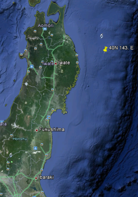
CURRENT STORM INFORMATION
Time/Date: 5:00 AM PhT Mon October 01, 2012
Location of Center: 40.0º N Lat 143.0º E Lon
Distance 1: 262 km (NE) away from Sendai, Japan
Distance 2: 369 km (SSE) away from Sapporo, Japan
Distance 3: 559 km (NNE) away from Tokyo, Japan
Distance 4: 756 km (SW) closer to Kuril Islands
MaxWinds (1-min avg): 75 kph (40 kts) near the center
Peak Wind Gusts: 95 kph (50 kts)
Present Movement: NNE @ 72 kph (39 kts)
Towards: Sea south of Kuril Islands
NOAA 24hr Rainfall Accum (near center): 100 mm (High)
Minimum Central Pressure: 993 millibars (hPa)
Saffir-Simpson Typhoon Scale: Tropical Storm
Size (in Diameter): 945 km (510 nm) [Very Large]
Wind Area Distribution (in Knots): Current Wind Profile
Max Sea Wave Height (near center): 30 ft
Possible Storm Surge Height: 1-3 ft (0.3-0.9 m)
T2K StormTracks (for Public): Google Map (Flash) | GIF (for Philippines only)
thenhbushmantyphoon.blogspot.com...
And the Wind Area Distribution (in Knots): Current Wind Profile:
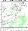
Click thumbnail for larger inage
rammb.cira.colostate.edu...

edit on 9/30/2012 by this_is_who_we_are because: thumb, typo
Looks like I'm late to the show anyway as the eye appears to have passes out to sea East North East of the Japanese mainland.
edit on 9/30/2012 by this_is_who_we_are because: photo
Condolences to the family of one japanese who died from the storm on Sunday, and to the other in Okinawa, as well as those hurt.
Saw the accelerated satellite feed of the path of Jelawat.
It strucked Japan Honshu but fortunately was downgraded to a tropical storm instead of super typhoon, with wind speeds dropping from 125mph to 65mph upon reaching Honshu, zig zagged north west wards towards the western seaboard, missing Fukishima altogether before heading back to the eastern sea ( Pacific Ocean)
Thanks to all concerned who prayed.
new topics
-
Has Tesla manipulated data logs to cover up auto pilot crash?
Automotive Discussion: 55 minutes ago -
whistleblower Captain Bill Uhouse on the Kingman UFO recovery
Aliens and UFOs: 5 hours ago -
1980s Arcade
General Chit Chat: 8 hours ago -
Deadpool and Wolverine
Movies: 8 hours ago -
Teenager makes chess history becoming the youngest challenger for the world championship crown
Other Current Events: 9 hours ago -
CIA botched its handling of sexual assault allegations, House intel report says
Breaking Alternative News: 10 hours ago
top topics
-
Lawsuit Seeks to ‘Ban the Jab’ in Florida
Diseases and Pandemics: 13 hours ago, 20 flags -
Starburst galaxy M82 - Webb Vs Hubble
Space Exploration: 15 hours ago, 13 flags -
The Superstition of Full Moons Filling Hospitals Turns Out To Be True!
Medical Issues & Conspiracies: 17 hours ago, 8 flags -
CIA botched its handling of sexual assault allegations, House intel report says
Breaking Alternative News: 10 hours ago, 8 flags -
15 Unhealthiest Sodas On The Market
Health & Wellness: 15 hours ago, 6 flags -
whistleblower Captain Bill Uhouse on the Kingman UFO recovery
Aliens and UFOs: 5 hours ago, 6 flags -
1980s Arcade
General Chit Chat: 8 hours ago, 4 flags -
Deadpool and Wolverine
Movies: 8 hours ago, 3 flags -
Teenager makes chess history becoming the youngest challenger for the world championship crown
Other Current Events: 9 hours ago, 3 flags -
Has Tesla manipulated data logs to cover up auto pilot crash?
Automotive Discussion: 55 minutes ago, 0 flags
active topics
-
Lawsuit Seeks to ‘Ban the Jab’ in Florida
Diseases and Pandemics • 23 • : burritocat -
Has Tesla manipulated data logs to cover up auto pilot crash?
Automotive Discussion • 1 • : andy06shake -
15 Unhealthiest Sodas On The Market
Health & Wellness • 36 • : tanstaafl -
My wife just had a very powerful prophetic dream - massive war in Israel...
The Gray Area • 12 • : SchrodingersRat -
-@TH3WH17ERABB17- -Q- ---TIME TO SHOW THE WORLD--- -Part- --44--
Dissecting Disinformation • 606 • : burritocat -
"We're All Hamas" Heard at Columbia University Protests
Social Issues and Civil Unrest • 199 • : FlyersFan -
It takes One to Be; Two to Tango; Three to Create.
Philosophy and Metaphysics • 7 • : Terpene -
Take it to the Media when you protest.. Don't let them ignore you!
Education and Media • 4 • : SchrodingersRat -
They Killed Dr. Who for Good
Rant • 62 • : FlyersFan -
Definitive 9.11 Pentagon EVIDENCE.
9/11 Conspiracies • 421 • : Lazy88
3