It looks like you're using an Ad Blocker.
Please white-list or disable AboveTopSecret.com in your ad-blocking tool.
Thank you.
Some features of ATS will be disabled while you continue to use an ad-blocker.

BREAKING: Proof NASA/JPL Copy & Pasted Images at Gale Crater Curiosity Landing Site on Mars!
page: 8share:
reply to post by ArMaP
The problem is not how many dollars to produce this altered images.
The real problem is WHY NASA use this kind of behaviour. UNSCIENTIFIC! Why use photoshop (or other imaging program) to show a fake rappresentation of that very important landing site and crater? WHY NASA don't show the real image of Gale Crater taken BEFORE the land?
It is absolutely clear that these photoshopped images are not from Curiosity mission, but from MRO and other probes! A photo mosaic from different imaging sources taken before.
So, The questions of many ATSers here remains:
What are we looking at?
Why are they duplicating parts of the images?
Are we sure that NASA has not already used Photoshop on other official images?
The digital manipulation duplication with Copy and Paste in Gale Crater is absolutely clear, proved and confirmed.
And I still don't understand why this thread is in the HOAX bin.
images like the one in the videos from the OP are easily done with software, you just have to "feed" the photos and the software does the rest.
The problem is not how many dollars to produce this altered images.
The real problem is WHY NASA use this kind of behaviour. UNSCIENTIFIC! Why use photoshop (or other imaging program) to show a fake rappresentation of that very important landing site and crater? WHY NASA don't show the real image of Gale Crater taken BEFORE the land?
It is absolutely clear that these photoshopped images are not from Curiosity mission, but from MRO and other probes! A photo mosaic from different imaging sources taken before.
So, The questions of many ATSers here remains:
What are we looking at?
Why are they duplicating parts of the images?
Are we sure that NASA has not already used Photoshop on other official images?
The digital manipulation duplication with Copy and Paste in Gale Crater is absolutely clear, proved and confirmed.
And I still don't understand why this thread is in the HOAX bin.
For All: this thread is not on: "If Curiosity is on Mars or not." (it is on Mars) or "if those photoshopped images coming from Curiosity or not"
(don't came from Curiosity but from other probes like Mars Reconnaissance Orbiter, Mars Express etc...).
This thread is on the fact, clear and proved, that NASA/JPL used photoshop altering the image of the landing site. WHY?
This thread is on the fact, clear and proved, that NASA/JPL used photoshop altering the image of the landing site. WHY?
Originally posted by Arken
This thread is on the fact, clear and proved, that NASA/JPL used photoshop altering the image of the landing site. WHY?
Your question has been answered many times. Are you refusing to read the answer?
reply to post by Arken
Too bad, you're getting flags and stars because half the posters here think that's what the thread is about.
Because some people just can't look at a topological map and visualize the terrain in their mind's eye.
For All: this thread is not on: "If Curiosity is on Mars or not." (it is on Mars) or "if those photoshopped images coming from Curiosity or not" (don't came from Curiosity but from other probes like Mars Reconnaissance Orbiter, Mars Express etc...).
Too bad, you're getting flags and stars because half the posters here think that's what the thread is about.
This thread is on the fact, clear and proved, that NASA/JPL used photoshop altering the image of the landing site. WHY?
Because some people just can't look at a topological map and visualize the terrain in their mind's eye.
reply to post by DJW001
WRONG! This is only your personal opinion. Do you thik that half of ATSers are dumb?
WRONG! This is only your personal opinion. NASA boffins think that people are dumb?
half the posters here think that's what the thread is about.
WRONG! This is only your personal opinion. Do you thik that half of ATSers are dumb?
Because some people just can't look at a topological map and visualize the terrain in their mind's eye.
WRONG! This is only your personal opinion. NASA boffins think that people are dumb?
edit on 23-9-2012 by Arken because: (no reason given)
Originally posted by AmatuerSkyWatcher
Originally posted by Arken
This thread is on the fact, clear and proved, that NASA/JPL used photoshop altering the image of the landing site. WHY?
Your question has been answered many times. Are you refusing to read the answer?
Sorry, maybe i missed it. what is the answer?
reply to post by Arken
I'm not going to sit here and type it out for you again. I have to simply think you are refusing to read the answer, and continue to ask your question regardless.
Start from page 2, and you will find the answer on pretty much, every page of this thread since.
I'm not going to sit here and type it out for you again. I have to simply think you are refusing to read the answer, and continue to ask your question regardless.
Start from page 2, and you will find the answer on pretty much, every page of this thread since.
Originally posted by Arken
WRONG! This is only your personal opinion. NASA boffins think that people are dumb?
edit on 23-9-2012 by Arken because: (no reason given)
No NASA doesn't think (some) people are dumb, they know some people are dumb. This thread is case and point, and is clear for all those with even half a brain, that they are indeed correct in that assumption.
reply to post by Arken
Perhaps you would care to make a drawing of the view you would see as you approach Tower Junction along the paved road from the north. Be sure to get the relative height of the peaks, steepness of the slope and depth of the valley correct:
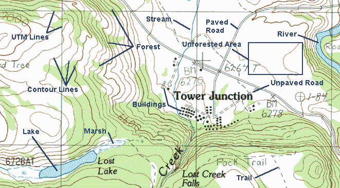
Is there something wrong with drawing all these contour lines on the map? Is it falsifying data? Is the USGS wasting taxpayer money doing this? Do you demand to see the original data?
Because some people just can't look at a topological map and visualize the terrain in their mind's eye.
WRONG! This is only your personal opinion. NASA boffins think that people are dumb?
Perhaps you would care to make a drawing of the view you would see as you approach Tower Junction along the paved road from the north. Be sure to get the relative height of the peaks, steepness of the slope and depth of the valley correct:
Is there something wrong with drawing all these contour lines on the map? Is it falsifying data? Is the USGS wasting taxpayer money doing this? Do you demand to see the original data?
Originally posted by AmatuerSkyWatcher
reply to post by DJW001
This should be entertaining...
Try answering Arken's question instead of pretending that the answer has already been given on previous pages. If it had, you could easily have linked to it. The truth is that you cannot answer his question and are forced to pretend that you don't need to supply one.
reply to post by micpsi
www.abovetopsecret.com...
Try answering Arken's question instead of pretending that the answer has already been given on previous pages. If it had, you could easily have linked to it. The truth is that you cannot answer his question and are forced to pretend that you don't need to supply one.
www.abovetopsecret.com...
reply to post by Arken
This is just a 'little' example of what is going on in the world. You can rub peoples noses in it...hell,.. even invite them to NASA and let them experiance first hand how a graphics artist is altering images...and still they do not belief somebody is messing with the "tax-payer".
Now I must be careful....same thing with those chemtrails. At some days you just need to look up...use your common "red-neck" sense and know something isn't how it should be.
You know what I consider the worst part...? That 'they' have lost all desentcy and respect to pay attention to the cover-up. 'They' are (becoming) sloppy. To some of us this is experianced as a slap in the face and an insult to our intelligence.
One can conclude that some governments are detached, or have disengaged from society and are not serving the people.....but something else.
edit on 23/9/2012 by zatara because: (no reason given)
ATTENTION!!!!!
The bickering stops here!!!!!!
Members are reminded to discuss the topic and not each other.
Failure to do this may result in further post removals and/or temporary Posting Bans.
This is the only reminder that will be posted about this.
edit on Sun Sep 23 2012 by DontTreadOnMe because: (no reason given)
Originally posted by Arken
Originally posted by AmatuerSkyWatcher
Originally posted by Arken
This thread is on the fact, clear and proved, that NASA/JPL used photoshop altering the image of the landing site. WHY?
Your question has been answered many times. Are you refusing to read the answer?
Sorry, maybe i missed it. what is the answer?
Well, the thread title is: "BREAKING: Proof NASA/JPL Copy & Pasted Images at Gale Crater Curiosity Landing Site on Mars!"
In your OP, you showed several videos that showed evidence that they had used photoshopping on images of Mars of Gale Crater.
You also said this was "proof" that NASA/JPL was covering up something.
(and by the way, you also said in the OP: "To Mod: feel free to move in appropriate forum.
Thx.", so it looks like they did just that).
You were given an answer several times in this thread as to why they have done this copy and pasting. Here's a list going to page 4 (I stopped after that):
Page 1
www.abovetopsecret.com...
Page 2
www.abovetopsecret.com...
Page 3
www.abovetopsecret.com...
www.abovetopsecret.com...
www.abovetopsecret.com...
You actually responded on Page 4, that you acknowledge this answer in this post here:
www.abovetopsecret.com...
You demanded high resolution photos of the area. That was provided to you. It's been explained how the landing site was selected.
It's been explained that the links to the photo's you are concerned about are for a "Fun" activity and is not used for scientific purposes (to even get to the images that they show in the YouTube video, you have to click on the "Fun" link on the front page)
Mars Exploration Program
NASA/JPL and other entities have acknowledged that they have to "copy and paste" images all the time, especially to make things work with multimedia programs like Google Earth, etc. They are having to take 2D images and make it work with 3D objects. This produces all sorts of artifacts, stretching, etc.
No where in your thread have you "proven" that they (NASA/JPL) are covering anything up (except for gaps, stitching and texture stretching......those they are trying to cover up).
Originally posted by micpsi
Originally posted by AmatuerSkyWatcher
reply to post by DJW001
This should be entertaining...
Try answering Arken's question instead of pretending that the answer has already been given on previous pages. If it had, you could easily have linked to it. The truth is that you cannot answer his question and are forced to pretend that you don't need to supply one.
Original question:
Originally posted by Arken
This thread is on the fact, clear and proved, that NASA/JPL used photoshop altering the image of the landing site. WHY?
One final time, just for dem HATERZ!1!!1!:
Originally posted by AmatuerSkyWatcher
Well what can I say...
A composite image from a computer game, designed to give the masses the 'curiosity experience' is being used as proof positive, of the nefarious deeds of NASA?
You people do realise that this is a computer generated 3d landscape, that has used an edited image, that has been sown together, then stretched over a 3d model as a skin right? RIGHT?
You do realise that this is for entertainment purposes, most probably for children right? RIGHT?
Originally posted by AmatuerSkyWatcher
Because the program the images were used on, is an entertainment facility, not required to have accuracy "down to 1 cm".
Originally posted by wildespace
Ok, I've asked around, and the possible reason for the copy&paste is that the needed to stitch several images from different sources together. There might have been some missing or corrupted data, so the next best thing for them to do was to clone an existing patch over it. If they had left a blank space, the conspiracy crowd would be crying about that (like they do with Google Sky).
Originally posted by eriktheawful
reply to post by Arken
Your question was answered on page one, by this post here:
www.abovetopsecret.com...
The purpose of that link was to entertain, help generate interest in the MSL project. It was not used to explore the landing site prior to Curiosity landing. So yes, those pictures are cut, copied, pasted and CGI rendered for that purpose: entertainment.
Originally posted by MacAnkka
What the..? Those images are for entertainment? But the video game you linked to in your first post is supposed to be scientifically correct? That link you just got is to the raw images that the video game is made of!
Originally posted by DJW001
For the benefit of people landing on this page without reading the entire thread, the YouTube videos are simply wrong when they claim these images are from Curiosity. They are not. They are clearly labeled as a CGI simulation of the landing site, put online months before the probe reached Mars. Several links have been posted to both raw and processed imagery of the landing site taken from orbit, despite the OP's claim that they are not available. Given that the claims made n the videos are false, this thread should have been moved to [HOAX].
Originally posted by DJW001
As to the question you keep asking, it has been answered countless times. If you are going to simulate a landscape for what is, in effect, a video game, you need to use generic fields for texture. What is so hard to understand about that?
Originally posted by DJW001
In this case, the entire thing is CGI. Nowhere is it claimed that it is anything but CGI. What part of "this video game uses information from previous probes to create a simulated 3D environment" do you not understand?
edit on 23-9-2012 by AmatuerSkyWatcher because: (no reason given)
You know what's blatantly obvious is how this guy smacks his mouth while talking - closed the video after about a minute of that - and now find out
he's using bad data.
reply to post by Arken
Arkin, no I am not an employee for NASA, I'm retired. However back in the Apollo lunar landing mission years, I did some catographic and photogrammetry contract work for NASA through my employeer, an agency which specialized in cartography and photogrammetry. I was never a NASA employee though.
The poor photo mosaic work comment was based on real past experiences of being in the position of reviewing other cartographers work back then on photo mosaics with similar mistakes - it did happen occasionally with technicians with little experience and is what I based those comments on - real experience of what happened, however these cases were usually caught in quality reviews by qualified professional cartographers with years of experience working with satellite photos.
You posted "I think they hide something that goes beyond our immagination. Something really huge."
You could very well be correct (and I hope that is the case), but since I don't have the photos I cannot make a judgement either way. I am certainly not making excuses for NASA, I thought it was clear that my position was just the opposite in this case, I am critical of what we are looking at here.
Those were good questions, I wish I had the raw data to know what is there for certain. Keep up the good posts and critical thinking, because just accepting the 'official' explanation is not always the full story.
reply to post by Arken
You posted: "Frankly I have not understood why my thread is inserted in HOAX forum."
I agree, this is a real event and deserves critical review and good questions; after all this our tax dollars at work so we all do have a vested interest.
You posted: "Frankly I have not understood why my thread is inserted in HOAX forum."
I agree, this is a real event and deserves critical review and good questions; after all this our tax dollars at work so we all do have a vested interest.
new topics
-
Who guards the guards
US Political Madness: 2 hours ago -
Has Tesla manipulated data logs to cover up auto pilot crash?
Automotive Discussion: 4 hours ago -
whistleblower Captain Bill Uhouse on the Kingman UFO recovery
Aliens and UFOs: 9 hours ago -
1980s Arcade
General Chit Chat: 11 hours ago
top topics
-
Lawsuit Seeks to ‘Ban the Jab’ in Florida
Diseases and Pandemics: 16 hours ago, 21 flags -
CIA botched its handling of sexual assault allegations, House intel report says
Breaking Alternative News: 14 hours ago, 9 flags -
whistleblower Captain Bill Uhouse on the Kingman UFO recovery
Aliens and UFOs: 9 hours ago, 9 flags -
Deadpool and Wolverine
Movies: 12 hours ago, 4 flags -
1980s Arcade
General Chit Chat: 11 hours ago, 4 flags -
Teenager makes chess history becoming the youngest challenger for the world championship crown
Other Current Events: 13 hours ago, 3 flags -
Who guards the guards
US Political Madness: 2 hours ago, 2 flags -
Has Tesla manipulated data logs to cover up auto pilot crash?
Automotive Discussion: 4 hours ago, 1 flags
active topics
-
15 Unhealthiest Sodas On The Market
Health & Wellness • 37 • : firerescue -
"We're All Hamas" Heard at Columbia University Protests
Social Issues and Civil Unrest • 211 • : Vermilion -
Lawsuit Seeks to ‘Ban the Jab’ in Florida
Diseases and Pandemics • 25 • : network dude -
IDF Intel Chief Resigns Over Hamas attack
Middle East Issues • 33 • : JAY1980 -
Mood Music Part VI
Music • 3088 • : TheWoker -
whistleblower Captain Bill Uhouse on the Kingman UFO recovery
Aliens and UFOs • 9 • : Ophiuchus1 -
The Democrats Take Control the House - Look what happened while you were sleeping
US Political Madness • 107 • : watchitburn -
They Killed Dr. Who for Good
Rant • 65 • : grey580 -
House Overwhelmingly Passes Funding for Ukraine, Israel and Taiwan
US Political Madness • 60 • : Justoneman -
Candidate TRUMP Now Has Crazy Judge JUAN MERCHAN After Him - The Stormy Daniels Hush-Money Case.
Political Conspiracies • 628 • : FlyersFan