It looks like you're using an Ad Blocker.
Please white-list or disable AboveTopSecret.com in your ad-blocking tool.
Thank you.
Some features of ATS will be disabled while you continue to use an ad-blocker.

BREAKING: Proof NASA/JPL Copy & Pasted Images at Gale Crater Curiosity Landing Site on Mars!
page: 11share:
reply to post by Unity_99
Show me the original Hale crater pic without that web site manipulation and if there are cities or buildings or roads there, then I will apologize.
Show me the original Hale crater pic without that web site manipulation and if there are cities or buildings or roads there, then I will apologize.
@dcmb1409 :
www.abovetopsecret.com...
This link has the real info on it, and the only kind of photo worth analyzing. Its not layered and compositted.
Too bad their high resolution ones are layers and partly artwork, eh?
www.abovetopsecret.com...
This link has the real info on it, and the only kind of photo worth analyzing. Its not layered and compositted.
Too bad their high resolution ones are layers and partly artwork, eh?
edit on 25-9-2012 by Unity_99 because: (no reason given)
reply to post by Unity_99
Your only telling half of the story and your resource is a pseudo-science web site with questionable information.
I still see no images of trees that are not deposits in the North polar region of mars nor can I find images that back up that web site claims that are not questionable.
This thread was about NASA manipulates images and you are proving that web sites are doing the same. Give us a reliable source for these claims.
www.marsanomalyresearch.com...
Well this part:
Very important information.
So, we have a smoothing technology, "it is the universal smoother texture image tampering that gives this general scene is worn look illusion"
Such creepo's I can't begin to settle down here.
Note, all the bolds are mine!
Well this part:
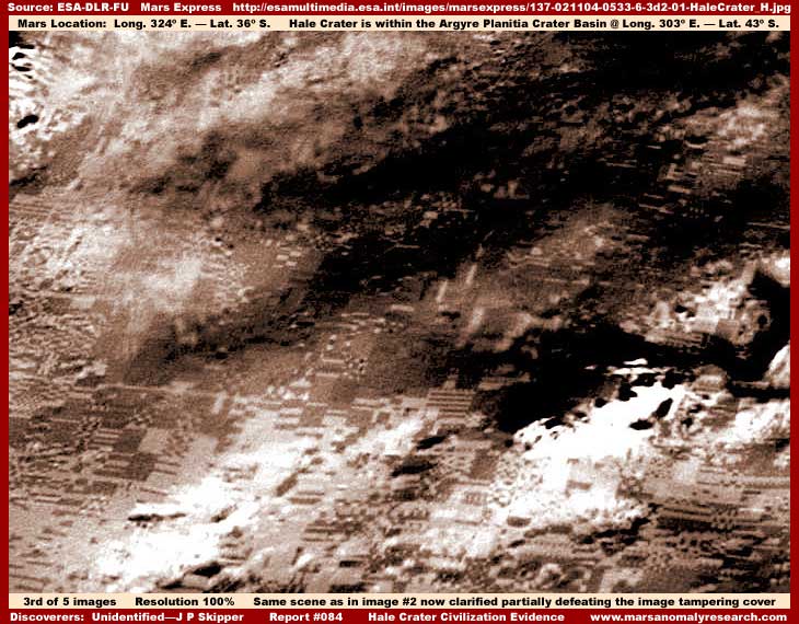
That fact wouldn't be so bad if the image manipulation was just limit to color but the truth, in my opinion, is that the ESA imaging is so heavy with map type carpeting image tampering obfuscation that quality anomalous discovery information can very rarely be found in it. In fact,this beautiful color rides on the back of this type of software mapping into the terrain. This problem is so prevalent in the ESA imaging as released to the public that I long ago came to the personal conclusion that it generally just isn't practically worth me devoting much of my very limited time to trying very hard to find something in it. Yet, no matter how diligent the tampering, mistakes are still made in its application and such mistakes can produce discoveries providing some real information. That is the situation we have here in this report with this image.
In the above first image, which is only 34% of the original full resolution size and similar to the even smaller type of imaging you will often see presented in the media, note the black arrow and label pointing out the evidence site location that the strong anomalous content of this report is based on. Don't see anything suggestive or anomalous there? Well you are seeing correctly because you are seeing only what the secrecy agenda wants you to see and that is essentially nothing but a little, and I do mean a little, geology in the form of just the tops of some rough mountainous terrain. This limited view coincides nicely with the fact that the main past and current scientific debate associated with the Hale Crater environs centers primarily around the question of possible past ancient water erosion on its worn slopes.
In other words, the focus is all about geological evidence and little else and this kind of beautiful designer imaging is designed to get in behind and reinforce that perception and psychology. Yet, all of the more smooth areas you see in the above first image, regardless of color or size, is map type smudge image tampering application and you'll note that this accumulatively constitutes the great bulk of the image area and only a little of any natural geological forms stick up through this covering.
In fact, it is the universal smoother texture image tampering that gives this general scene is worn look illusion that current scientific debate is so focussed on. This kind of thing not only serves to cover up any anomalous evidence that may be present in a particular image like this one, it also from official image to image accumulatively in the many hundreds and thousands creates the universal perception illusion that what one is looking at in these images is all real terrain when the truth is that only the tops of some of the rougher geology is real in a scene like this. This is how misdirection and manipulation of perception is done in the world of planetary satellite imaging.
For those of you who may be hesitant to accept this, resolution is only a matter of common sense. I invite you to take a look at the fifth and last image in my previous Report #055 titled Towers In The Sun. This standard commercial quality technology image demonstrates satellite older than ESA's current science imaging technology of an Earth city from the satellite over 400+ miles out as compared to the 230 mile average for satellites circling Mars and through Earth's heavy atmospheric envelope and cloud cover as compared to Mars thin much clearer atmospheric cover.
Earth satellite images like this should provide very clear insight as to what kind of minimum quality that we have a right to expect from this planetary science imaging that uses the best cutting edge equipment of the time and not available commercially. Yet, this is clearly not what we are getting. Oh the real and much clearer science imaging data is out there somewhere within secrecy control but only the poorest quality heavily manipulated and obscured imaging full of misdirection and illusion is made available to the public and researchers as evidenced by the first and second images you see here in this report.
Very important information.
So, we have a smoothing technology, "it is the universal smoother texture image tampering that gives this general scene is worn look illusion"
Such creepo's I can't begin to settle down here.
Note, all the bolds are mine!
So, don't get all excited over anything that looks high resolution and pixels, because, its called evidence tampering, fraud, and exhortion. In
fact, I would like some investigators to list all the crimes this represents, because I sense an enormous long lists of crimes taking place. And the
category classified doesnt interest me, and think its high time that that civilian panels, start to determine what is going on with the huge list of
humanity's progression, and simple scientific truth's that we're not privy to, buried in that Classified List. I mean if Classified is only used
to enforce their unnatural and non inherent right to rule this earth its TREASON.
Really. here's one of the original MOC images that was manipulated by the internet. No cities,buildings, or roads. And I can get more from more than
one source or questionable web sites on the internet.
MGS MOC Release No. MOC2-257, 17 November 2000
www.msss.com...
MGS MOC Release No. MOC2-257, 17 November 2000
www.msss.com...
edit on 25-9-2012 by dcmb1409 because: (no reason given)
reply to post by Arken
Having reviewed the presentation I am inclined to believe (in my own armchair non-expert fashion) that there is definite photo-manipulation going on. Even more so now that this thread has been moved to the dustbin. I mean the Hoax forum.
ETA:
That thumbs up is for the thread, not for where it has been moved.
edit on 9/25/2012 by this_is_who_we_are because: Edit To Add
Well since we can't flag this very good thread and worthy discussion. 10 thumbs up!
Originally posted by Unity_99
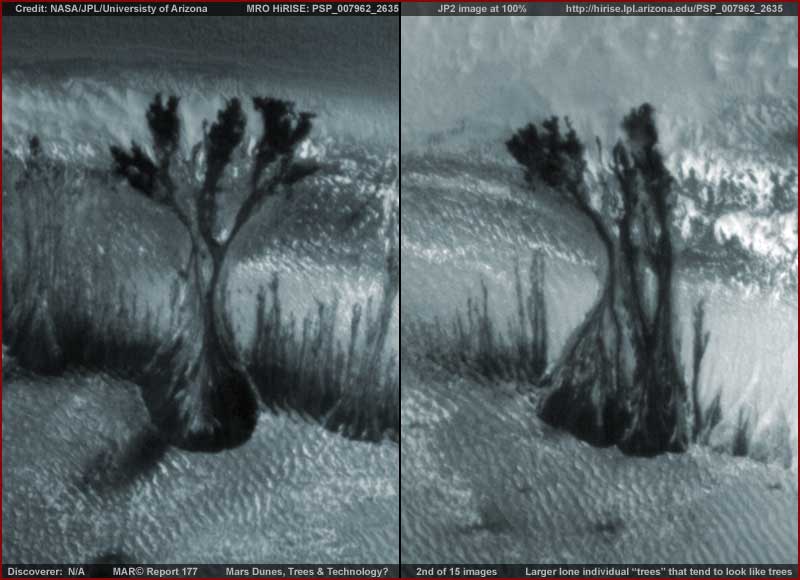
If those are trees, where are their shadows?
Originally posted by Unity_99
What do you think it represents?
I remember that one, it was the discussed for some time. What it shows is what happens when we use an image with less colours than we should as a texture to map over a 3D image.
If you look at the individual images that were used to make that composite image we will see that there aren't any of those "features".
Originally posted by Unity_99
This one is cool, and google mars screws up too in their obvious tampering of evidence.
Nobody interested in Mars images should use Google Mars as their main tool. Yes, it's useful to locate the areas in which we are interested, but the way they compress the images and make the mosaics makes their images less reliable than they could be.
Originally posted by Unity_99
The photo's are art work, and if the thread you linked has any other conclusion, I would call it fraud too, if the people on it were drawing other conclusions and weren't ordinary citizens, and we can't prove those things here, but I can express that I don't believe alot of posters here are.
Those are not photos, those ESA images are made with a high resolution image (from the red channel, if I'm not mistaken), two lower resolution images from the green and blue channels and the height data from the stereo photos converted to a computer generated 3D scene.
The original photos are available for anyone that wants to do real work, as an image expert like Skipper should know.
reply to post by ArMaP
And the ones that are up on his site are actual photos often with links, and that one in the crater actually comes from the European flyover, if I recall correctly.
I don't need to find all the science photos don't even know where the links are. But normally what is put out is a photo without artwork inserted or programs smoothing everything, filling stuff in, putting on layers. Just complete fraud, criminal, for its treason to me, its to protect their un natural rule over this world, instead of advance, progress humanity and science.
Normally what we'd be dealing with are found in the analysis of many Nasa photos on that site, where evidence of photoshopping takes place, for example with the water.
Now we're getting something more exotic.
Originally posted by ArMaP
Originally posted by Unity_99
If those are trees, where are their shadows?
Rotate This image up side down.
These are not trees, but something Fluid and dark that flow.

The problem is: What is this liquid dark material?
Originally posted by this_is_who_we_are
reply to post by Arken
Having reviewed the presentation I am inclined to believe (in my own armchair non-expert fashion) that there is definite photo-manipulation going on. Even more so now that this thread has been moved to the dustbin. I mean the Hoax forum.
ETA:
That thumbs up is for the thread, not for where it has been moved.edit on 9/25/2012 by this_is_who_we_are because: Edit To Add
Thanks for your kind words. I appreciate
Sadly, there are too many foxes in this henhouse.
reply to post by Arken
Dark sediments will do that too.
Fine sands, dust, dirt that were suspended or carried by water can show the shape of water's flow long after the water had disappeared.
You can see this yourself after a good rain storm here where I live. everyone has dirt driveways, and we live on a very large hill. The clay sand and dirt washes out into the road and leaves patterns that look like the picture in your post.
Originally posted by Arken
reply to post by Unity_99
GALE CRATER contains other big surprises...... Thread incoming.
I hope you're not using that photo as source.
Originally posted by Unity_99
And the ones that are up on his site are actual photos often with links, and that one in the crater actually comes from the European flyover, if I recall correctly.
That Hale crater image is from ESA.
I don't need to find all the science photos don't even know where the links are.
The science photos are the ones that people should focus on, instead of focusing in "pretty pictures".
But normally what is put out is a photo without artwork inserted or programs smoothing everything, filling stuff in, putting on layers. Just complete fraud, criminal, for its treason to me, its to protect their un natural rule over this world, instead of advance, progress humanity and science.
Not fraud or treason, unless they explicitly say that the images show a different thing.
Normally what we'd be dealing with are found in the analysis of many Nasa photos on that site, where evidence of photoshopping takes place, for example with the water.
Never seen it on scientific images.
Now we're getting something more exotic.
reply to post by ArMaP
It's fraud and treason if they don't tell people these are altered, and have many assuming this is it. From their photoshopping days to all of the latest. Its to further a small elite group and keep the rest as slaves.
It's fraud and treason if they don't tell people these are altered, and have many assuming this is it. From their photoshopping days to all of the latest. Its to further a small elite group and keep the rest as slaves.
edit on 25-9-2012 by Unity_99 because: (no reason given)
new topics
-
Any one suspicious of fever promotions events, major investor Goldman Sachs card only.
The Gray Area: 1 hours ago -
God's Righteousness is Greater than Our Wrath
Religion, Faith, And Theology: 6 hours ago -
Electrical tricks for saving money
Education and Media: 9 hours ago -
VP's Secret Service agent brawls with other agents at Andrews
Mainstream News: 10 hours ago -
Sunak spinning the sickness figures
Other Current Events: 11 hours ago -
Nearly 70% Of Americans Want Talks To End War In Ukraine
Political Issues: 11 hours ago
top topics
-
VP's Secret Service agent brawls with other agents at Andrews
Mainstream News: 10 hours ago, 9 flags -
Cats Used as Live Bait to Train Ferocious Pitbulls in Illegal NYC Dogfighting
Social Issues and Civil Unrest: 14 hours ago, 8 flags -
Electrical tricks for saving money
Education and Media: 9 hours ago, 4 flags -
Nearly 70% Of Americans Want Talks To End War In Ukraine
Political Issues: 11 hours ago, 3 flags -
Sunak spinning the sickness figures
Other Current Events: 11 hours ago, 3 flags -
Late Night with the Devil - a really good unusual modern horror film.
Movies: 13 hours ago, 2 flags -
Any one suspicious of fever promotions events, major investor Goldman Sachs card only.
The Gray Area: 1 hours ago, 2 flags -
The Good News According to Jesus - Episode 1
Religion, Faith, And Theology: 16 hours ago, 1 flags -
God's Righteousness is Greater than Our Wrath
Religion, Faith, And Theology: 6 hours ago, 0 flags
active topics
-
SETI chief says US has no evidence for alien technology. 'And we never have'
Aliens and UFOs • 61 • : andy06shake -
The Reality of the Laser
Military Projects • 47 • : F2d5thCavv2 -
Definitive 9.11 Pentagon EVIDENCE.
9/11 Conspiracies • 423 • : Lazy88 -
God's Righteousness is Greater than Our Wrath
Religion, Faith, And Theology • 11 • : andy06shake -
Election Year 2024 - Interesting Election-Related Tidbits as They Happen.
2024 Elections • 73 • : Threadbarer -
Sunak spinning the sickness figures
Other Current Events • 8 • : McUrnsalso -
-@TH3WH17ERABB17- -Q- ---TIME TO SHOW THE WORLD--- -Part- --44--
Dissecting Disinformation • 661 • : Justoneman -
HORRIBLE !! Russian Soldier Drinking Own Urine To Survive In Battle
World War Three • 36 • : TheMisguidedAngel -
British TV Presenter Refuses To Use Guest's Preferred Pronouns
Education and Media • 146 • : Consvoli -
Nearly 70% Of Americans Want Talks To End War In Ukraine
Political Issues • 19 • : Consvoli