It looks like you're using an Ad Blocker.
Please white-list or disable AboveTopSecret.com in your ad-blocking tool.
Thank you.
Some features of ATS will be disabled while you continue to use an ad-blocker.

More Mysterious Nazca Lines From Space
page: 1share:
Most here have heard of the intriguing Nazca Lines of Peru which are the most outstanding group of geoglyphs in the world. Etched in the surface of
the desert pampa sand are hundreds of straight lines, geometric shapes and pictures of animals and birds – and their patterns are only clearly
visible from the air and space.
Here are some from a collection taken from space that many may never have seen before. Enjoy!


The renderings are explained by historians and archaeologists as part of a practice involving the worship of deities associated with the availability of water, and thus the fertility of crops.
The lines were interpreted primarily as sacred paths leading to points of worship and the figures were of sacred animals and objects to invoke their aid.
But what about the massive, exactly symmetric, arrow straight lines more than 50 km long that don’t conform to terrain geometry they’re made on which were discovered when NASA launched its Landsat imagery? These geoglyphs can only be seen from space!

Nazca lines (Peru).
ETM+/Landsat 7 (10/11/02).
Source: Landsat USGS gallery
So, the question is: Whodunit? And why? Were these ‘sacred paths leading to points of worship’? Really?
Images courtesy: Priyadarshni[/ii]
Here are some from a collection taken from space that many may never have seen before. Enjoy!
The renderings are explained by historians and archaeologists as part of a practice involving the worship of deities associated with the availability of water, and thus the fertility of crops.
The lines were interpreted primarily as sacred paths leading to points of worship and the figures were of sacred animals and objects to invoke their aid.
But what about the massive, exactly symmetric, arrow straight lines more than 50 km long that don’t conform to terrain geometry they’re made on which were discovered when NASA launched its Landsat imagery? These geoglyphs can only be seen from space!
Nazca lines (Peru).
ETM+/Landsat 7 (10/11/02).
Source: Landsat USGS gallery
So, the question is: Whodunit? And why? Were these ‘sacred paths leading to points of worship’? Really?
Images courtesy: Priyadarshni[/ii]
edit on 5-9-2012 by OrionHunterX because: (no reason given)
i am so intrigued by nazca
i did notice none of the animal glyphs are represented here... only lines?
i did notice none of the animal glyphs are represented here... only lines?
reply to post by OrionHunterX
I have been fascinated by Nazca ever since reading "Chariots of the Gods" back in the 70's.And I have never accepted the explanations for these glyphs provided by mainstream science.I suppose we may never know the truth.Unless the Gods finally return.
I have been fascinated by Nazca ever since reading "Chariots of the Gods" back in the 70's.And I have never accepted the explanations for these glyphs provided by mainstream science.I suppose we may never know the truth.Unless the Gods finally return.
Originally posted by okamitengu
i am so intrigued by nazca
i did notice none of the animal glyphs are represented here... only lines?
Yep! This is only about the lines. I wanted to stress that the lines made DO NOT follow the terrain configuration - no ups and downs into valleys and up hills which would otherwise make them look wavy and meandering. These run absolutely straight over them!! That means the lines were drawn using complex geometry so that they look arrow straight from above like they were drawn on a flat piece of land!
Now isn't that mind blowing?
reply to post by OrionHunterX
.
This stuff is awesome. But one question for you,
you say it do not follow the terrain, but the last
image is at an angle. That would suggest that if
you looked straight down from exactly above, the
line would actualy be wavy, would it not?
Ofcourse I could be very wrong
.
.
This stuff is awesome. But one question for you,
you say it do not follow the terrain, but the last
image is at an angle. That would suggest that if
you looked straight down from exactly above, the
line would actualy be wavy, would it not?
Ofcourse I could be very wrong
.
I remember reading and then seeing a show about this on ancient aliens, the next to last picture, of all the holes that are made in a perfect grid
pattern were said to be done by a giant drilling rig for the sake of core samples. it does kinda look like that to me as well.
It went on to say that it was done to take samples for gold deposits, i wander if there is any gold down there?
I also remember Vondanikan talking about the sumerians, and they were bred and taught, so they could mine the gold for the "Gods" who would return much later to collect it. I wander if their was any actual merit to that, as summer was the first civilization we know of, and the first written language. Their own recorrds say as much, if the translations are acurate.
One more word on the lines, I know that this has been said to death already, but dont they resemble airport runways alot? One of them even totally leveled off a mountain top to perfect level, without somehow leaving behind any trace of the ruble one would expect to see from such a project being evident anywhere.
If these pictures were of mars, ats would be full of "its an alien base!". i wonder how many mars and moon anomalies will turn out to be lines drawn
for no reason......
Im not sure that picture really is at an angle, i feel like thats an illusion. Either way, the main line clearly dips into a valley yet doesnt conform to the valley.
Originally posted by snewpers
reply to post by OrionHunterX
.
This stuff is awesome. But one question for you,
you say it do not follow the terrain, but the last
image is at an angle. That would suggest that if
you looked straight down from exactly above, the
line would actualy be wavy, would it not?
Ofcourse I could be very wrong
.
Im not sure that picture really is at an angle, i feel like thats an illusion. Either way, the main line clearly dips into a valley yet doesnt conform to the valley.
It is difficult to maintain a straight line, I wonder how they did it, no survey equipment, no views from above, how did they do it? My town can't
run a sewer line under a highway and meet up on the other side, seriously, they have tried 3 times.
In the second picture it looks like an eye to me with the lines coming out of it. It is south-southwest of center. See it? Or is it just my eyes
playing tricks on me?
reply to post by WildWorld
I do see it, I don't think it is intentional, it is interesting. The scale is small compared to the lines.
I do see it, I don't think it is intentional, it is interesting. The scale is small compared to the lines.
Originally posted by Iamschist
reply to post by WildWorld
I do see it, I don't think it is intentional, it is interesting. The scale is small compared to the lines.
I don't think it's intentional either. It's cool though.....sort of reminds me of the all seeing eye in the pyramid except not on top.
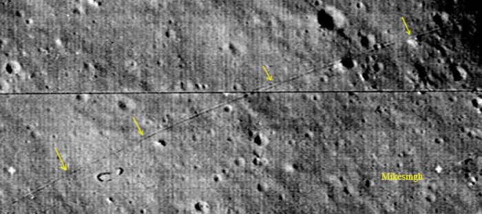
Originally posted by phroziac
If these pictures were of mars, ats would be full of "its an alien base!". i wonder how many mars and moon anomalies will turn out to be lines drawn for no reason......
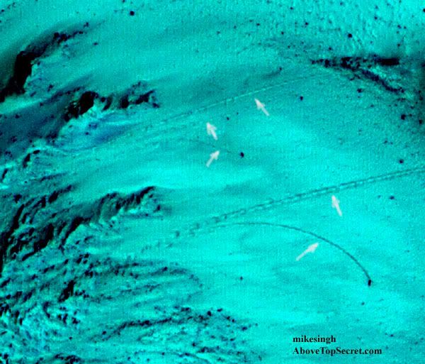
Like this line on the Moon? Though it's not straight, it looks like a parallel track which was photographed before any Lunar rover rolled on the Moon!
And this one from Mars...
Some nice pics there thanks
Also, I heard that one of the most unusual things in Peru is where a very large area at the top of a mountain has been litterally sliced off, have you heard of that?
Also, I heard that one of the most unusual things in Peru is where a very large area at the top of a mountain has been litterally sliced off, have you heard of that?
reply to post by Iamschist
long before the theodolite was invented builders were making long straight lines using the three to four sighting staff system .
as for the company that could not line up the tunnel or pipe line in your town , i suggest they employ more professional people in the future or contract the company that built the channel tunnel between england and france , when they met up there was less than a centimeter error , and that was over twelve miles in length .
Originally posted by TheMindWar
Some nice pics there thanks
Also, I heard that one of the most unusual things in Peru is where a very large area at the top of a mountain has been litterally sliced off, have you heard of that?
Are you meaning this...

And the historians and archaeologists contend that these were made as sacred paths leading to points of worship!! Doesn't that sound pretty dumb? Does this look like a sacred path? Did they need to slice off the top of a hill for making a path that can land a Jumbo? And where does the so called 'sacred' path lead to?
edit on 5-9-2012 by OrionHunterX because: (no reason given)
reply to post by OrionHunterX
Fascinating! Starred and flagged.
Some of those patterns remind me of a computer circuit board. The last one looks as if they're pointing to some interesting archaeological possibilities.
Fascinating! Starred and flagged.
Some of those patterns remind me of a computer circuit board. The last one looks as if they're pointing to some interesting archaeological possibilities.
Here's another...
But hang on!! That's not in Nazca! IT'S AREA 51!
Notice the similarity? Was Nazca an 'Area 51' a few thousand years ago? Just saying.
Pic: World Mysteries

But hang on!! That's not in Nazca! IT'S AREA 51!
Notice the similarity? Was Nazca an 'Area 51' a few thousand years ago? Just saying.
Pic: World Mysteries
edit on 5-9-2012 by OrionHunterX because: (no reason given)
reply to post by OrionHunterX
Every time I take a look at these I get a feel there was ARIEL support present somehow? Nice presentation OrionHunterX. Maybe there is something below some of these markers.
Every time I take a look at these I get a feel there was ARIEL support present somehow? Nice presentation OrionHunterX. Maybe there is something below some of these markers.
reply to post by OrionHunterX
Nice find! S & F!
A lot of people are super intrigued about funny looking rocks on Mars. We have more mysterious things here on Earth that we are still finding, by way of space.
A lot of people are super intrigued about funny looking rocks on Mars. We have more mysterious things here on Earth that we are still finding, by way of space.
new topics
-
Two Serious Crimes Committed by President JOE BIDEN that are Easy to Impeach Him For.
US Political Madness: 28 minutes ago -
911 emergency lines are DOWN across multiple states
Breaking Alternative News: 28 minutes ago -
Former NYT Reporter Attacks Scientists For Misleading Him Over COVID Lab-Leak Theory
Education and Media: 2 hours ago -
Why did Phizer team with nanobot maker
Medical Issues & Conspiracies: 2 hours ago -
Pro Hamas protesters at Columbia claim hit with chemical spray
World War Three: 3 hours ago -
Elites disapearing
Political Conspiracies: 5 hours ago -
A Personal Cigar UFO/UAP Video footage I have held onto and will release it here and now.
Aliens and UFOs: 5 hours ago -
Go Woke, Go Broke--Forbes Confirms Disney Has Lost Money On Star Wars
Movies: 7 hours ago -
Freddie Mercury
Paranormal Studies: 7 hours ago
top topics
-
British TV Presenter Refuses To Use Guest's Preferred Pronouns
Education and Media: 13 hours ago, 17 flags -
Go Woke, Go Broke--Forbes Confirms Disney Has Lost Money On Star Wars
Movies: 7 hours ago, 12 flags -
Pro Hamas protesters at Columbia claim hit with chemical spray
World War Three: 3 hours ago, 10 flags -
Trump To Hold Dinner with President of Poland At Trump Tower Tonight
2024 Elections: 15 hours ago, 8 flags -
Tucker Carlson interviews Christian pastor from Bethlehem.
Middle East Issues: 14 hours ago, 7 flags -
Freddie Mercury
Paranormal Studies: 7 hours ago, 7 flags -
Elites disapearing
Political Conspiracies: 5 hours ago, 7 flags -
A Personal Cigar UFO/UAP Video footage I have held onto and will release it here and now.
Aliens and UFOs: 5 hours ago, 5 flags -
Nirvana - Immigrant Song
Music: 12 hours ago, 4 flags -
Why did Phizer team with nanobot maker
Medical Issues & Conspiracies: 2 hours ago, 3 flags
active topics
-
Go Woke, Go Broke--Forbes Confirms Disney Has Lost Money On Star Wars
Movies • 15 • : 5thHead -
AARO/Dr Kirkpatrick-Caught Lying in UAP report.
Aliens and UFOs • 23 • : Arbitrageur -
-@TH3WH17ERABB17- -Q- ---TIME TO SHOW THE WORLD--- -Part- --44--
Dissecting Disinformation • 515 • : TheGoondockSaint -
Two Serious Crimes Committed by President JOE BIDEN that are Easy to Impeach Him For.
US Political Madness • 0 • : WeMustCare -
911 emergency lines are DOWN across multiple states
Breaking Alternative News • 0 • : TheGoondockSaint -
Pro Hamas protesters at Columbia claim hit with chemical spray
World War Three • 10 • : KrustyKrab -
Elites disapearing
Political Conspiracies • 16 • : annonentity -
Israel ufo shoot down drones?
Aliens and UFOs • 25 • : introufo2 -
Why did Phizer team with nanobot maker
Medical Issues & Conspiracies • 3 • : Unknownparadox -
Terrifying Encounters With The Black Eyed Kids
Paranormal Studies • 43 • : TheMichiganSwampBuck