It looks like you're using an Ad Blocker.
Please white-list or disable AboveTopSecret.com in your ad-blocking tool.
Thank you.
Some features of ATS will be disabled while you continue to use an ad-blocker.

50,000 people have 90 mins evacuate , Percy Quinn Dam expected to break
page: 1share:
News just breaking.
The dam is expected to break due to rainfall from Issac.
www.nbc33tv.com...
www.reuters.com...
THe news is flagging that a failure is imminent. Just found this stroy which seems to suggest it has already failed.
www.flickr.com...
The dam is expected to break due to rainfall from Issac.
www.nbc33tv.com...
Due to the imminent failure of the Lake Tangipahoa Dam in Percy Quinn State Park in Mississippi, near the town of McComb, up to 60,000 people downstream in Louisiana need to immediately evacuate, Tangipahoa Parish President Gordon Burgess told local television station WWLTV.
www.reuters.com...
edit on 30-8-2012 by lacrimaererum because: (no reason
given)
THe news is flagging that a failure is imminent. Just found this stroy which seems to suggest it has already failed.
www.accuweather.com...
A potential dam break occurred at Percy Quinn Park on the Tangipahoa River, south of McComb, Miss.
www.flickr.com...
edit on 30-8-2012 by lacrimaererum because: (no reason
given)
edit on 30-8-2012 by lacrimaererum because: (no reason given)
Issac just got real, This is scary scary stuff. I hope they are able to get everyone out in time. My thoughts go out to the people of LA.
[Updated 12:10 p.m. ET] Pike County Civil Defense's latest Facebook update says: "Flood warning for the Tangipahoa River at Osyka. The dam at Lake Tangipahoa, better known as Percy Quin State Park, has been damaged by the torrential rains from Hurricane Isaac, but is intact, and is not leaking. We are monitoring it. All residents below the dam that live along the Tangipahoa River are being notified of the damage."
[Updated 12:07 p.m. ET] As of about 20 minutes ago, a National Guard helicopter was maintaining position over the dam to monitor its integrity, The Times-Picayune reports. As of 11:45 p.m., it was still holding, the New Orleans paper reported.
Source
Hey McComb is several miles UPSTREAM!!!! as in NORTH. Magnolia is south and near the creek that the dam will take out
Wheres Obama and FEMA?
Glad they have a Governor to take swift action and get those people out of there. Don’t want to interrupt Obamas campaign stops.
This ticks me off to no end. Its reported all over the news that its a CAT1 storm. It may have low winds but its a super slow moving storm. Dumping TONS of water in an area that is under a severe drought. Severe drought plus lots of water equel flash floods.
edit on 30-8-2012 by camaro68ss
because: (no reason given)
where is the news conference?
nvm, video is up now
nvm, video is up now
edit on 30-8-2012 by Gwampo because: (no reason given)
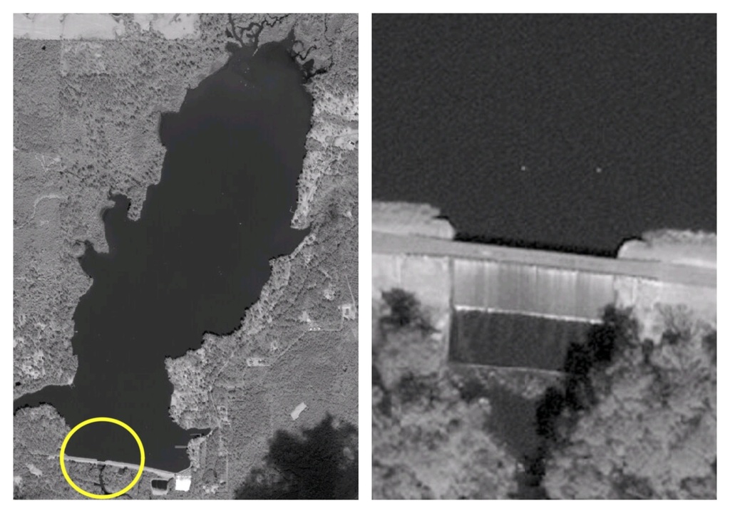
This is mostly a earth dam, once there is one breach the rest is sure to follow.
Link
Lake Tangipahoa Dam Percy Dam is on the Tangipahoa River in Pike County, Mississippi and is used for recreation purposes. It was built in 1940. It has a normal surface area of 554 acres.
Lake Tangipahoa Dam Percy is of earthen construction. Its height is 34 feet with a length of 2300 feet. Maximum discharge is 1331 cubic feet per second. Its capacity is 8112 acre feet. Normal storage is 4841 acre feet. It drains an area of 56.8 square miles.
edit on 30-8-2012 by
GuidedKill because: (no reason given)
^ Exactly...
Also, there are no houses in site if it does break....

Also, there are no houses in site if it does break....
reply to post by camaro68ss
You are completely wrong. Here are all of the things FEMA already has in place. Including plans.
Sorry, not gonna pull a George W. this time around.
You are completely wrong. Here are all of the things FEMA already has in place. Including plans.
Sorry, not gonna pull a George W. this time around.
live video
the Dam has not failed, it's only damaged.
the Dam has not failed, it's only damaged.
edit on 30-8-2012 by voyger2 because: (no reason given)
Originally posted by Hefficide
Sorry, not gonna pull a George W. this time around.
If you read his Memoirs, which I have, you'll know exactly why he didn't land.
reply to post by CALGARIAN
Link says it drains into 56 square miles!!!! That's a lot of land to cover and I'm sure there is a town or two in that 56 miles. Not a major city or population area but still very very scary and dangerous!!
Link says it drains into 56 square miles!!!! That's a lot of land to cover and I'm sure there is a town or two in that 56 miles. Not a major city or population area but still very very scary and dangerous!!
I think any political allegory attempted here would be in bad taste. but...
Percy Edwards Quin (October 30, 1872 – February 4, 1932) was an American politician from Mississippi. He served as a Democrat in the United States House of Representatives from 1913 to 1932.
Percy Edwards Quin (October 30, 1872 – February 4, 1932) was an American politician from Mississippi. He served as a Democrat in the United States House of Representatives from 1913 to 1932.
Originally posted by GuidedKill
This is mostly a earth dam, once there is one breach the rest is sure to follow.
Link
Lake Tangipahoa Dam Percy Dam is on the Tangipahoa River in Pike County, Mississippi and is used for recreation purposes. It was built in 1940. It has a normal surface area of 554 acres.
Lake Tangipahoa Dam Percy is of earthen construction. Its height is 34 feet with a length of 2300 feet. Maximum discharge is 1331 cubic feet per second. Its capacity is 8112 acre feet. Normal storage is 4841 acre feet. It drains an area of 56.8 square miles.edit on 30-8-2012 by GuidedKill because: (no reason given)
The earthen dam, at the time I believe the largest earthen dam in the world at Oroville CA, was cracked during an earthquake but it did hold and was repaired. It was they said cracked all the way through near the bottom.
reply to post by lacrimaererum
CNN reports same. Fifty to sixty thousand being evacuated.
THe news is flagging that a failure is imminent. Just found this stroy which seems to suggest it has already failed.
CNN reports same. Fifty to sixty thousand being evacuated.
Interesting. I hope it's more MSM created "panic and doom" and not a real threat. Would suck to have a 6 foot wall of water tearing at you!
Originally posted by Jeremiah65
Interesting. I hope it's more MSM created "panic and doom" and not a real threat. Would suck to have a 6 foot wall of water tearing at you!
You can be swept away with as little as 1 foot of water at 15 MPH. Now imagine you get swept away at 15 mph and hit a tree head on…. Your dead. It is dangerous
edit on 30-8-2012 by camaro68ss because: (no reason given)
www.google.org...
www.google.org...
Civil Emergency Message for Tangipahoa Parish, LA
Print the Alert
Send via Email
Share on Twitter
Share on Facebook
Active for next 2 hours, 6 minutesLocation: Tangipahoa
Due to the dam failure, water levels on the Tangipahoa River near Kentwood are expected to rise to 17 feet quickly. This is a very similar level to what was experienced in 1990 and 1983. If you were impacted by the floods of 1990 or 1983, leave the area immediately for higher ground.
www.google.org...
Weather channel now reporting that there is a 100 foot breach in the dam. Flood stage for the river below the dam is 15 foot. The current river level
is 17.5 foot to 21 feet in some areas.. River levels are expected to rise to over 21 feet and maybe even 28-30 feet if the dam breaks.
At least that's what the weather channel lady just said.
At least that's what the weather channel lady just said.
edit on 30-8-2012 by GuidedKill because: (no reason given)
new topics
-
Any one suspicious of fever promotions events, major investor Goldman Sachs card only.
The Gray Area: 1 hours ago -
God's Righteousness is Greater than Our Wrath
Religion, Faith, And Theology: 5 hours ago -
Electrical tricks for saving money
Education and Media: 9 hours ago -
VP's Secret Service agent brawls with other agents at Andrews
Mainstream News: 10 hours ago -
Sunak spinning the sickness figures
Other Current Events: 11 hours ago -
Nearly 70% Of Americans Want Talks To End War In Ukraine
Political Issues: 11 hours ago
top topics
-
VP's Secret Service agent brawls with other agents at Andrews
Mainstream News: 10 hours ago, 9 flags -
Cats Used as Live Bait to Train Ferocious Pitbulls in Illegal NYC Dogfighting
Social Issues and Civil Unrest: 14 hours ago, 8 flags -
Electrical tricks for saving money
Education and Media: 9 hours ago, 4 flags -
Nearly 70% Of Americans Want Talks To End War In Ukraine
Political Issues: 11 hours ago, 3 flags -
Sunak spinning the sickness figures
Other Current Events: 11 hours ago, 3 flags -
Late Night with the Devil - a really good unusual modern horror film.
Movies: 13 hours ago, 2 flags -
Any one suspicious of fever promotions events, major investor Goldman Sachs card only.
The Gray Area: 1 hours ago, 2 flags -
The Good News According to Jesus - Episode 1
Religion, Faith, And Theology: 16 hours ago, 1 flags -
God's Righteousness is Greater than Our Wrath
Religion, Faith, And Theology: 5 hours ago, 0 flags
active topics
-
Election Year 2024 - Interesting Election-Related Tidbits as They Happen.
2024 Elections • 73 • : Threadbarer -
Sunak spinning the sickness figures
Other Current Events • 8 • : McUrnsalso -
God's Righteousness is Greater than Our Wrath
Religion, Faith, And Theology • 10 • : randomuser2034 -
-@TH3WH17ERABB17- -Q- ---TIME TO SHOW THE WORLD--- -Part- --44--
Dissecting Disinformation • 661 • : Justoneman -
SETI chief says US has no evidence for alien technology. 'And we never have'
Aliens and UFOs • 59 • : andy06shake -
HORRIBLE !! Russian Soldier Drinking Own Urine To Survive In Battle
World War Three • 36 • : TheMisguidedAngel -
British TV Presenter Refuses To Use Guest's Preferred Pronouns
Education and Media • 146 • : Consvoli -
Nearly 70% Of Americans Want Talks To End War In Ukraine
Political Issues • 19 • : Consvoli -
Terrifying Encounters With The Black Eyed Kids
Paranormal Studies • 76 • : Consvoli -
Samuel Aun Woer
Religion, Faith, And Theology • 27 • : helebi20