It looks like you're using an Ad Blocker.
Please white-list or disable AboveTopSecret.com in your ad-blocking tool.
Thank you.
Some features of ATS will be disabled while you continue to use an ad-blocker.

Large Quake Off Coast Of El Salvador. Local tsunami warning issued!
page: 17
share:
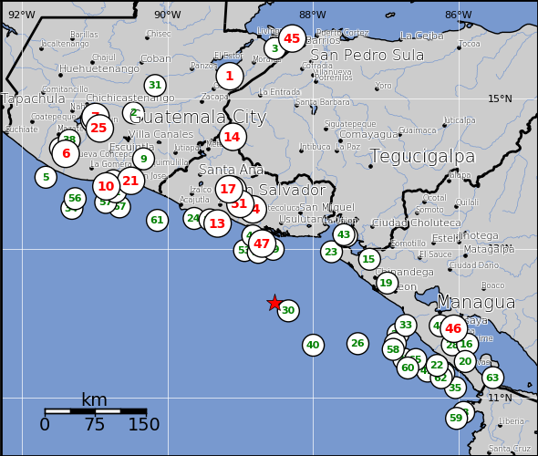
Cali's been shaking, but this 7.4 just hit about 40 miles offshore from El Salvador and about 100 miles south and offshore from the capital of San
Salvador.
No word yet on any tsunami or damage. It's about 40 miles deep.
No word yet on any tsunami or damage. It's about 40 miles deep.
Earthquake Details
This event has been reviewed by a seismologist.
Magnitude 7.4
Date-Time
Monday, August 27, 2012 at 04:37:23 UTC
Sunday, August 26, 2012 at 10:37:23 PM at epicenter
Location 12.279°N, 88.530°W
Depth 52.9 km (32.9 miles)
Region OFFSHORE EL SALVADOR
Distances
118 km (74 miles) S (185°) from Usulután, Usulután, El Salvador
138 km (86 miles) SSW (196°) from San Miguel, San Miguel, El Salvador
139 km (86 miles) SSW (212°) from La Unión, La Unión, El Salvador
169 km (105 miles) SSE (156°) from SAN SALVADOR, El Salvador
Location Uncertainty horizontal +/- 16.5 km (10.3 miles); depth +/- 8.8 km (5.5 miles)
Parameters NST=362, Nph=362, Dmin=130.2 km, Rmss=1.02 sec, Gp=115°,
M-type=regional moment magnitude (Mw), Version=8
Source
Magnitude: USGS NEIC (WDCS-D)
Location: USGS NEIC (WDCS-D)
Event ID usc000c7yw
edit on 27-8-2012 by webpirate because: Update
Pretty deep quake, usually the shallow ones (20 miles or less) are the ones that really cause destruction. Hopefully everyone's okay!
reply to post by muse7
This actually isn't all that deep. Quakes are commonly felt hundreds of miles down. This was just a little more than 50 miles down. And remember...the people who live in this area often live in inadequate structures.
Similar quakes in the same area have caused widespread damage. Often from either tsunami's or landslides.
edit on 27-8-2012 by webpirate because: Update
Tsunami Warning issues for Central America Pacific Coast...
ptwc.weather.gov...
ptwc.weather.gov...
edit on 27-8-2012 by usaman1983 because: (no reason given)
reply to post by webpirate
The 2 columns on the end represent initial deaths, and total deaths including secondary and primary means.
And the quakes I selected are a couple as indicated on the map close to the same area. Obviously the third one with all of the deaths was the closest in size to the current one.
The 2 columns on the end represent initial deaths, and total deaths including secondary and primary means.
**30 6.5 Nicaragua 12.168, -88.34, 26km1995-06-14 11:11:49 VI (561,350) 0 0
**40 6.7 Nicaragua 11.706, -87.998, 12km1998-08-23 13:57:11 VI (650,155) 0 0
**47 7.7 San Miguel, El Salvador 13.07, -88.7, 38km2001-01-13 17:33:31 IX (655,194) 267 852 Landslide
And the quakes I selected are a couple as indicated on the map close to the same area. Obviously the third one with all of the deaths was the closest in size to the current one.
I posted this on the other thread about the quake
ISSUED AT 0458Z 27 AUG 2012
THIS BULLETIN APPLIES TO AREAS WITHIN AND BORDERING THE PACIFIC
OCEAN AND ADJACENT SEAS...EXCEPT ALASKA...BRITISH COLUMBIA...
WASHINGTON...OREGON AND CALIFORNIA.
THIS EARTHQUAKE APPEARS TO BE A SLOW EARTHQUAKE WITH ADDITIONAL
TSUNAMI POTENTIAL. THEREFORE A WARNING IS BEING ISSUED.
... A TSUNAMI WARNING IS IN EFFECT ...
A TSUNAMI WARNING IS IN EFFECT FOR
COSTA RICA / NICARAGUA / EL SALVADOR / HONDURAS / GUATEMALA /
PANAMA / MEXICO
FOR ALL OTHER AREAS COVERED BY THIS BULLETIN... IT IS FOR
INFORMATION ONLY AT THIS TIME.
THIS BULLETIN IS ISSUED AS ADVICE TO GOVERNMENT AGENCIES. ONLY
NATIONAL AND LOCAL GOVERNMENT AGENCIES HAVE THE AUTHORITY TO MAKE
DECISIONS REGARDING THE OFFICIAL STATE OF ALERT IN THEIR AREA AND
ANY ACTIONS TO BE TAKEN IN RESPONSE.
AN EARTHQUAKE HAS OCCURRED WITH THESE PRELIMINARY PARAMETERS
ORIGIN TIME - 0437Z 27 AUG 2012
COORDINATES - 12.7 NORTH 88.5 WEST
DEPTH - 54 KM
LOCATION - OFF COAST OF CENTRAL AMERICA
MAGNITUDE - 7.3
EVALUATION
IT IS NOT KNOWN THAT A TSUNAMI WAS GENERATED. THIS WARNING IS
BASED ONLY ON THE EARTHQUAKE EVALUATION. AN EARTHQUAKE OF THIS
SIZE HAS THE POTENTIAL TO GENERATE A DESTRUCTIVE TSUNAMI THAT CAN
STRIKE COASTLINES IN THE REGION NEAR THE EPICENTER WITHIN MINUTES
TO HOURS. AUTHORITIES IN THE REGION SHOULD TAKE APPROPRIATE
ACTION IN RESPONSE TO THIS POSSIBILITY. THIS CENTER WILL MONITOR
SEA LEVEL GAUGES NEAREST THE REGION AND REPORT IF ANY TSUNAMI
WAVE ACTIVITY IS OBSERVED. THE WARNING WILL NOT EXPAND TO OTHER
AREAS OF THE PACIFIC UNLESS ADDITIONAL DATA ARE RECEIVED TO
WARRANT SUCH AN EXPANSION.
Trying to find out if my parents felt it in Cartago Costa Rica. So far I haven't heard anything from them. It's midnight there anyway, probably
slept through it........I hope
new topics
-
Electrical tricks for saving money
Education and Media: 1 hours ago -
VP's Secret Service agent brawls with other agents at Andrews
Mainstream News: 2 hours ago -
Sunak spinning the sickness figures
Other Current Events: 3 hours ago -
Nearly 70% Of Americans Want Talks To End War In Ukraine
Political Issues: 3 hours ago -
Late Night with the Devil - a really good unusual modern horror film.
Movies: 5 hours ago -
Cats Used as Live Bait to Train Ferocious Pitbulls in Illegal NYC Dogfighting
Social Issues and Civil Unrest: 6 hours ago -
The Good News According to Jesus - Episode 1
Religion, Faith, And Theology: 8 hours ago -
HORRIBLE !! Russian Soldier Drinking Own Urine To Survive In Battle
World War Three: 10 hours ago
top topics
-
SETI chief says US has no evidence for alien technology. 'And we never have'
Aliens and UFOs: 17 hours ago, 8 flags -
Cats Used as Live Bait to Train Ferocious Pitbulls in Illegal NYC Dogfighting
Social Issues and Civil Unrest: 6 hours ago, 8 flags -
Florida man's trip overseas ends in shock over $143,000 T-Mobile phone bill
Social Issues and Civil Unrest: 13 hours ago, 8 flags -
VP's Secret Service agent brawls with other agents at Andrews
Mainstream News: 2 hours ago, 7 flags -
Former Labour minister Frank Field dies aged 81
People: 15 hours ago, 4 flags -
Bobiverse
Fantasy & Science Fiction: 13 hours ago, 3 flags -
HORRIBLE !! Russian Soldier Drinking Own Urine To Survive In Battle
World War Three: 10 hours ago, 3 flags -
Nearly 70% Of Americans Want Talks To End War In Ukraine
Political Issues: 3 hours ago, 3 flags -
Sunak spinning the sickness figures
Other Current Events: 3 hours ago, 3 flags -
Late Night with the Devil - a really good unusual modern horror film.
Movies: 5 hours ago, 2 flags
active topics
-
Terrifying Encounters With The Black Eyed Kids
Paranormal Studies • 73 • : burritocat -
SETI chief says US has no evidence for alien technology. 'And we never have'
Aliens and UFOs • 43 • : boatguy12 -
The Reality of the Laser
Military Projects • 45 • : 5thHead -
President BIDEN Vows to Make Americans Pay More Federal Taxes in 2025 - Political Suicide.
2024 Elections • 125 • : ImagoDei -
Cats Used as Live Bait to Train Ferocious Pitbulls in Illegal NYC Dogfighting
Social Issues and Civil Unrest • 13 • : Albone -
Spectrophilia - Women Who Have Had Affairs With Ghosts Say Spooks Are Better Lovers Than Real Men
Paranormal Studies • 31 • : charlyv -
HORRIBLE !! Russian Soldier Drinking Own Urine To Survive In Battle
World War Three • 29 • : doubledan717 -
-@TH3WH17ERABB17- -Q- ---TIME TO SHOW THE WORLD--- -Part- --44--
Dissecting Disinformation • 651 • : 777Vader -
VP's Secret Service agent brawls with other agents at Andrews
Mainstream News • 19 • : NoCorruptionAllowed -
VirginOfGrand says hello
Introductions • 5 • : burritocat
7