It looks like you're using an Ad Blocker.
Please white-list or disable AboveTopSecret.com in your ad-blocking tool.
Thank you.
Some features of ATS will be disabled while you continue to use an ad-blocker.

Curiosity's First Major Science Target Chosen -- 'Glenelg'
page: 19
share:
According to what mission scientists said in today's Press conference (August 17), they have planned out the first long drive and science work for the
Rover. Over the next few of weeks, the rover plans to make its first major drive to an area scientists have nicknamed "Glenelg".
Part of the reason it will take a few weeks to get there is that this is Curiosity's first long drive, and they need to proceed cautiously, plus they plan to stop along the way and do some other science (scoop up dirt, etc).
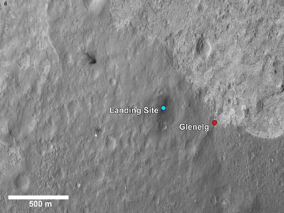
Glenelg is scientifically interesting because it seems to be an are where three different types of materials are coming together. You can see on the image above that there is a brighter soil at the top, a darker and more cratered area to the bottom, and a darker area to the left, which contains the gravely soil in which Curiosity landed.
The lightest material at the top is something scientists observed from orbital analysis of the area years ago that interests them, and that is areas of "High Thermal Inertia", or areas that seem to retain, as seen in this image more heat than surrounding areas, as seen in this false-color image (areas in red):
 ["Landing Site" annotations added by me]
Source and image description
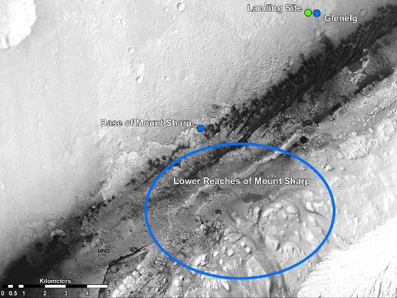
After spending several weeks (or even a month+) at Glenelg, the Rover will be sent to the base of Mt. Sharp, to the southwest of the landing site, as seen in this image scientists are calling the "Martian Treasure map" -- a trip that may take several months to complete:
Source
Along the way, Curiosity will be drilling rocks, vaporizing rocks with its laser beam, and analyzing the materials...
...So anyway, it looks like a lot of cool science awaits!
Source
This image shows a closer view of the landing site of NASA's Curiosity rover and a destination nearby known as Glenelg. Curiosity landed inside Gale Crater on Mars on Aug. 5 PDT (Aug. 6 EDT) at the blue dot. It is planning on driving to an area marked with a red dot that is nicknamed Glenelg. That area marks the intersection of three kinds of terrain. Starting clockwise from the top of this image, scientists are interested in this brighter terrain because it may represent a kind of bedrock suitable for eventual drilling by Curiosity. The next terrain shows the marks of many small craters and intrigues scientists because it might represent an older or harder surface. The third, which is the kind of terrain Curiosity landed in, is interesting because scientists can try to determine if the same kind of rock texture at Goulburn, an area where blasts from the descent stage rocket engines scoured away some of the surface, also occurs at Glenelg.
Part of the reason it will take a few weeks to get there is that this is Curiosity's first long drive, and they need to proceed cautiously, plus they plan to stop along the way and do some other science (scoop up dirt, etc).
Glenelg is scientifically interesting because it seems to be an are where three different types of materials are coming together. You can see on the image above that there is a brighter soil at the top, a darker and more cratered area to the bottom, and a darker area to the left, which contains the gravely soil in which Curiosity landed.
The lightest material at the top is something scientists observed from orbital analysis of the area years ago that interests them, and that is areas of "High Thermal Inertia", or areas that seem to retain, as seen in this image more heat than surrounding areas, as seen in this false-color image (areas in red):
Source and image description
After spending several weeks (or even a month+) at Glenelg, the Rover will be sent to the base of Mt. Sharp, to the southwest of the landing site, as seen in this image scientists are calling the "Martian Treasure map" -- a trip that may take several months to complete:
Martian Treasure Map
...Then, the rover will aim to drive to the blue spot marked "Base of Mt. Sharp", which is a natural break in the dunes that will allow Curiosity to begin scaling the lower reaches of Mount Sharp. At the base of Mt. Sharp are layered buttes and mesas that scientists hope will reveal the area's geological history.
Source
Along the way, Curiosity will be drilling rocks, vaporizing rocks with its laser beam, and analyzing the materials...
...So anyway, it looks like a lot of cool science awaits!
edit on 8/17/2012 by Soylent Green Is People because: (no reason given)
I can't wait,Curiosity is going to tell us amazing things.
The target at the base of Mt Sharp looks great-lots of washed/blown down dusty sediments for it to analyze.
The journey to get there should be amazing as well.
What an acheivement NASA,way to go!!
The target at the base of Mt Sharp looks great-lots of washed/blown down dusty sediments for it to analyze.
The journey to get there should be amazing as well.
What an acheivement NASA,way to go!!
Glenelg may be the first major destination, but there will be some science happening before they go to Glenelg. In one of the first uses of
Curiosity's science instruments, NASA plans to zap one of the rocks adjacent to the lading site with its laser (the ChemCam), to ionize some of that
rock, and :sniff" the vapor for analysis:
mars.jpl.nasa.gov...
I believe I heard a scientist say that they think it is just common basalt, but they see it as an opportunity to test the instruments.
ChemCam Laser Sets its Sights on First Martian Target
mars.jpl.nasa.gov...
This close-up image shows the first target NASA's Curiosity rover aims to zap with its Chemistry and Camera (ChemCam) instrument. ChemCam will be firing a laser at this rock, provisionally named N165, and analyzing the glowing, ionized gas, called plasma, that the laser excites. The instrument will analyze that spark with a telescope and identify the chemical elements in the target.
I believe I heard a scientist say that they think it is just common basalt, but they see it as an opportunity to test the instruments.
“Rock N-165 looks like your typical Mars rock, about three inches (seven centimeters) wide and it's about 10 feet away,” Wiens said. “We are going to hit it with 14 milliJoules of energy 30 times in 10 seconds. It is not only going to be an excellent test of our system, but it should be pretty cool too.”
ChemCam Laser Sets its Sights on First Martian Target
edit on 8/17/2012 by Soylent Green Is People because: (no reason given)
reply to post by Soylent Green Is People
Nice update thanks for the fine work. Amazing to me how close curiosity was able to land near where the mission scientists have to chosen to begin studying mt sharp. I hope that within the next year we are all arguing is that a fossil or not.
Nice update thanks for the fine work. Amazing to me how close curiosity was able to land near where the mission scientists have to chosen to begin studying mt sharp. I hope that within the next year we are all arguing is that a fossil or not.
new topics
-
4 plans of US elites to defeat Russia
New World Order: 1 hours ago -
Thousands Of Young Ukrainian Men Trying To Flee The Country To Avoid Conscription And The War
Other Current Events: 4 hours ago -
12 jurors selected in Trump criminal trial
US Political Madness: 7 hours ago -
Iran launches Retalliation Strike 4.18.24
World War Three: 7 hours ago -
Israeli Missile Strikes in Iran, Explosions in Syria + Iraq
World War Three: 8 hours ago
top topics
-
George Knapp AMA on DI
Area 51 and other Facilities: 13 hours ago, 25 flags -
Israeli Missile Strikes in Iran, Explosions in Syria + Iraq
World War Three: 8 hours ago, 16 flags -
Louisiana Lawmakers Seek to Limit Public Access to Government Records
Political Issues: 16 hours ago, 7 flags -
Iran launches Retalliation Strike 4.18.24
World War Three: 7 hours ago, 6 flags -
Not Aliens but a Nazi Occult Inspired and then Science Rendered Design.
Aliens and UFOs: 13 hours ago, 5 flags -
12 jurors selected in Trump criminal trial
US Political Madness: 7 hours ago, 4 flags -
Thousands Of Young Ukrainian Men Trying To Flee The Country To Avoid Conscription And The War
Other Current Events: 4 hours ago, 4 flags -
The Tories may be wiped out after the Election - Serves them Right
Regional Politics: 17 hours ago, 3 flags -
4 plans of US elites to defeat Russia
New World Order: 1 hours ago, 2 flags
9