It looks like you're using an Ad Blocker.
Please white-list or disable AboveTopSecret.com in your ad-blocking tool.
Thank you.
Some features of ATS will be disabled while you continue to use an ad-blocker.

Turin papyrus map from ancient Egypt
page: 122
share:
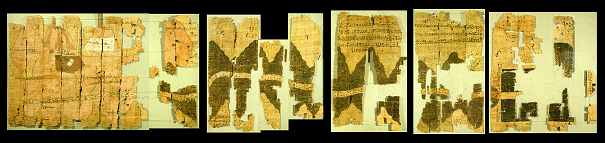
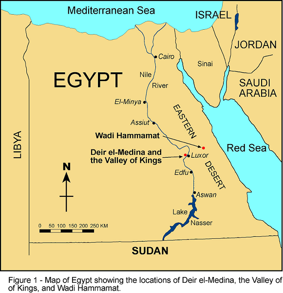
In 1814 and 1821 the French Consul General in Egypt had agents of his looking for antiquities. One of these men, Bernardino Drovetti, found something extraordinary, an ancient Egyptian map drawn on a scroll of papyrus paper. The map came from a private tomb in the ancient village of Deir el-Medina, ancient Thebes now called Luxor
Soon after this the map was sold to the ruler of the northern Italian Kingdom of Sardenia and Piedmont. In 1824, the King established the Egyptian Museum in Turin and here the map has resided ever since.
The map fragments were eventually recombined to form a single map about 280 cm long by 41 cm wide (110 by 17 inches) . The map was rolled up when discovered and subsequently handled, and this explains the especially poor preservation of the outer abraded surface of the scroll.
The current reconstruction of the map in the Egyptian Museum, which dates to the early 1900’s, is incorrect in several of its details. New looks at the papyrus have been made and will shown below.
The writer of the map was known
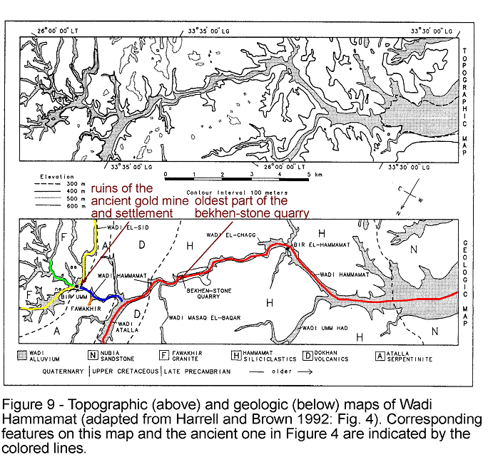
The map was made about 1150 BC by the well-known ‘Scribe of the Tomb‘ Amennakhte, son of Ipuy. It was prepared for one of the quarrying expeditions sent to Wadi Hammamat by king Ramesses IV (1156-1150 BC) of the New Kingdom’s 20th Dynasty.
The purpose of these expeditions was to obtain blocks of bekhen-stone that would be carved into statues of the gods, king and other notables. A now famous rock-cut inscription or stela (officially designated CM 12) was left on the quarry wall by this king to commemorate his final and largest expedition during the third year of his six-year reign.
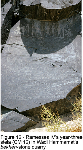
According to the inscription, this included 8,362 men, which makes it the largest recorded quarrying expedition to Wadi Hammamat after one about 800 years earlier during the Middle Kingdom’s 12th Dynasty. It is almost certainly for Ramesses IV’s big expedition that the map was made, but what purpose it served is unclear. It could not have been a road map showing the way to the quarry because it only covers a small area with the 75 km between Wadi Hammamat and the Nile Valley excluded. Most likely, it was drawn as a visual record of the expedition to be viewed by either Ramesses IV or Ramessenakhte, the High Priest of Amun in Thebes, who organized the expedition for the king.
Now what does the map show?
A detail of the map
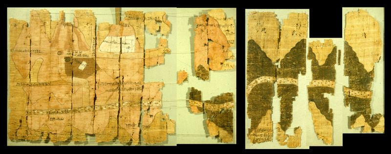
A comparison of the map to a modern map
For full details see the excellent website by ProfessorJames A. Harrell, Ph.D
His website provides marvlous details about the map
What is on the back of the map?
A guide to what the numbers mean
I constructed this thread many months ago but forgot to put it up, here it is - correcting the mistake!
edit on 8/8/12 by Hanslune because:
(no reason given)
Hi Hans ,
That's pretty darned awsome, so the map is more of a "post card " of the expedition, than a map.
I wonder whether the 8k figure is just workmen or the expedition as a whole, either way that is a sizable group of people to take out into the desert.
What a chore to keep all those people fed and watered. Thearticle says the wadi is about 40 miles from the nile valley, were there water sources nearby?
It also sounds like the quarry wasn't used on a regular basis, if they had to organize and expedition.
wow thats awesome, ty for putting it together for us, i love these diary types even when its just old books or maps with things inscribed on sides + i
love anything ancient civ, related ^^ star for this fer sure !! btw cant correct what you didnt mess up, better late than never ^^
Originally posted by punkinworks10
Hi Hans ,
That's pretty darned awsome, so the map is more of a "post card " of the expedition, than a map.
I wonder whether the 8k figure is just workmen or the expedition as a whole, either way that is a sizable group of people to take out into the desert.
What a chore to keep all those people fed and watered. Thearticle says the wadi is about 40 miles from the nile valley, were there water sources nearby?
It also sounds like the quarry wasn't used on a regular basis, if they had to organize and expedition.
A rather large postcard! They probably needed that many people, the AE not having any domesticated animals to carry all the food and necessities - and to drag out the rocks they were going for.
Water sources? Sorry don't know. I've been out to that general area (farther to the north) and it was very desolate and dry
S & F
As always Hans very informative.
I appreciate the links and info.
As always Hans very informative.
I appreciate the links and info.
You forgot to post it?......scuse me for a sec. (ha ha snort hrmph!) sorry
Yeah right! :0
sounds somewhat like the 'journey to the centre' thread I WAS goimng to do!
Anyway...
The writing on the back seems like it confirms the nine, just my two cents.
link
Nice thread by the way x & very cool
Yeah right! :0
sounds somewhat like the 'journey to the centre' thread I WAS goimng to do!
Anyway...
The writing on the back seems like it confirms the nine, just my two cents.
link
Nice thread by the way x & very cool
ILL DO some research for you guys when i go in december for winter solstice
thegreatconvergence2012.com...
thegreatconvergence2012.com...
Originally posted by Hanslune
Originally posted by punkinworks10
Hi Hans ,
That's pretty darned awsome, so the map is more of a "post card " of the expedition, than a map.
I wonder whether the 8k figure is just workmen or the expedition as a whole, either way that is a sizable group of people to take out into the desert.
What a chore to keep all those people fed and watered. Thearticle says the wadi is about 40 miles from the nile valley, were there water sources nearby?
It also sounds like the quarry wasn't used on a regular basis, if they had to organize and expedition.
A rather large postcard! They probably needed that many people, the AE not having any domesticated animals to carry all the food and necessities - and to drag out the rocks they were going for.
Water sources? Sorry don't know. I've been out to that general area (farther to the north) and it was very desolate and dry
I have read somewhere, not sure where, but in the absence of pack animals , in ancient times, a man could only carry enough food andd water for three days or about 60k worth of walking before replenisment, without localized foraging. In marching armies of the past foragers made up a good portion of the noncombat people. There is not a whole lot of forage available in that area, so I'd bet large portion of that 8k plus contingent was food and water porters.
Having spent severals days travelling , by off road motorcycle, through the mojave and great basin, I can appreciate what it took to mount such an expedition and come back.
new topics
-
Pentagon acknowledges secret UFO project, the Kona Blue program | Vargas Reports
Aliens and UFOs: 48 minutes ago -
Boston Dynamics say Farewell to Atlas
Science & Technology: 56 minutes ago -
I hate dreaming
Rant: 1 hours ago -
Is the origin for the Eye of Horus the pineal gland?
Philosophy and Metaphysics: 3 hours ago -
Man sets himself on fire outside Donald Trump trial
Mainstream News: 3 hours ago -
Biden says little kids flip him the bird all the time.
2024 Elections: 3 hours ago -
The Democrats Take Control the House - Look what happened while you were sleeping
US Political Madness: 4 hours ago -
Sheetz facing racial discrimination lawsuit for considering criminal history in hiring
Social Issues and Civil Unrest: 4 hours ago -
In an Historic First, In N Out Burger Permanently Closes a Location
Mainstream News: 6 hours ago -
MH370 Again....
Disaster Conspiracies: 6 hours ago
top topics
-
In an Historic First, In N Out Burger Permanently Closes a Location
Mainstream News: 6 hours ago, 14 flags -
The Democrats Take Control the House - Look what happened while you were sleeping
US Political Madness: 4 hours ago, 10 flags -
Thousands Of Young Ukrainian Men Trying To Flee The Country To Avoid Conscription And The War
Other Current Events: 16 hours ago, 8 flags -
A man of the people
Medical Issues & Conspiracies: 11 hours ago, 8 flags -
Man sets himself on fire outside Donald Trump trial
Mainstream News: 3 hours ago, 7 flags -
Biden says little kids flip him the bird all the time.
2024 Elections: 3 hours ago, 6 flags -
4 plans of US elites to defeat Russia
New World Order: 13 hours ago, 4 flags -
Is the origin for the Eye of Horus the pineal gland?
Philosophy and Metaphysics: 3 hours ago, 4 flags -
Sheetz facing racial discrimination lawsuit for considering criminal history in hiring
Social Issues and Civil Unrest: 4 hours ago, 3 flags -
Are you ready for the return of Jesus Christ? Have you been cleansed by His blood?
Religion, Faith, And Theology: 9 hours ago, 3 flags
active topics
-
Mood Music Part VI
Music • 3063 • : lilzazz -
12 jurors selected in Trump criminal trial
US Political Madness • 106 • : ImagoDei -
The defamation of Mary Magdalene
Religion, Faith, And Theology • 13 • : Solvedit -
The Democrats Take Control the House - Look what happened while you were sleeping
US Political Madness • 35 • : ImagoDei -
Russian intelligence officer: explosions at defense factories in the USA and Wales may be sabotage
Weaponry • 176 • : BernnieJGato -
-@TH3WH17ERABB17- -Q- ---TIME TO SHOW THE WORLD--- -Part- --44--
Dissecting Disinformation • 543 • : SideEyeEverything1 -
Elites disapearing
Political Conspiracies • 33 • : 0bserver1 -
Man sets himself on fire outside Donald Trump trial
Mainstream News • 29 • : ByeByeAmericanPie -
Fossils in Greece Suggest Human Ancestors Evolved in Europe, Not Africa
Origins and Creationism • 78 • : strongfp -
Pentagon acknowledges secret UFO project, the Kona Blue program | Vargas Reports
Aliens and UFOs • 2 • : Macenroe1982
22