It looks like you're using an Ad Blocker.
Please white-list or disable AboveTopSecret.com in your ad-blocking tool.
Thank you.
Some features of ATS will be disabled while you continue to use an ad-blocker.

Test flight over Peru could revolutionize archaeological mapping
page: 14
share:
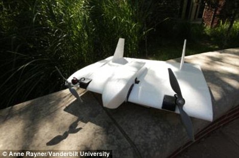
Archaeological sites that currently take years to map will be completed in minutes if tests underway in Peru of a new system being developed at
Vanderbilt University go well
They call it SUAVe or Semi-autonomous Unmanned Aerial Vehicle
Tests are scheduled from mid-July to mid-August at the abandoned colonial era town of Mawchu Llacta in Peru
news.vanderbilt.edu...
I look forward to the results from this
Cran
They call it SUAVe or Semi-autonomous Unmanned Aerial Vehicle
“It can take two or three years to map one site in two dimensions,” Wernke said. “The SUAVe (pronounced SWAH-vey) system should transform how we map large sites that take several seasons to document using traditional methods. It will provide much higher resolution imagery than even the best satellite imagery, and it will produce a detailed three-dimensional model.”
Tests are scheduled from mid-July to mid-August at the abandoned colonial era town of Mawchu Llacta in Peru
news.vanderbilt.edu...
I look forward to the results from this
Cran
Very cool.
I'm just sad they don't mention what kind of mapping suite their using in regard to equipment.
Laser rangefinding?
IR/UV?
Radar?
Traditional visual video?
Combinations of these for a complete image package?
I wish also they'd have shown some projected result 'demonstration' proof of concept maps.
Exciting none the less. Can't wait to see what this results in, and how it may impact already known sites.
That`ll let people get to those previously un-explored ruins that are still out there in the jungles and rain forest of S. America. Of course you will
still need boots on the ground to do any real exploring but the little UAV will make a huge difference.
Cant wait to see if they find anything big.
Cant wait to see if they find anything big.
Originally posted by mysterioustranger
LIDAR. LASER mapping-almost immediate results with computer
I didn't notice that anywhere in the article. Where did you find that information?
reply to post by dainoyfb
From the link
I have looked and can-not find anymore info on this
Cran
Where did you find that information
From the link
It will provide much higher resolution imagery than even the best satellite imagery, and it will produce a detailed three-dimensional model.”
I have looked and can-not find anymore info on this
Cran
reply to post by cranspace
Sorry for the confusion cranspace, I was asking mysterioustranger where they got the information that the imaging was LIDAR based. I don't see that being mentioned in the article or at sites linked to in the article.
Sorry for the confusion cranspace, I was asking mysterioustranger where they got the information that the imaging was LIDAR based. I don't see that being mentioned in the article or at sites linked to in the article.
reply to post by dainoyfb
Just this week I believe in Science Digest (?). It spoke of Archeo-deicoveries being exposed quickly for the air by use of laser-radar (LIDAR). It removes the vegetation and ground above sites temples etc. Ill locate that article for you. It has photos as well. Check back here in a bit...
Just this week I believe in Science Digest (?). It spoke of Archeo-deicoveries being exposed quickly for the air by use of laser-radar (LIDAR). It removes the vegetation and ground above sites temples etc. Ill locate that article for you. It has photos as well. Check back here in a bit...
reply to post by dainoyfb
Here you go: It was National Geographic
news.nationalgeographic.c... om/news/2010/05/photogalleries/100520-ancient-maya-city-belize-science-pictures/
Here you go: It was National Geographic
news.nationalgeographic.c... om/news/2010/05/photogalleries/100520-ancient-maya-city-belize-science-pictures/
edit on 06-10-2010 by mysterioustranger because: (no
reason given)
reply to post by cranspace
Thanks.
I still don't see a connection between the project mentioned in the OP and LIDAR mentioned there. The reason I'm being picky is that using LIDAR on a craft that small to do mapping of a a large area in minutes is quite a feat. Also, the company that makes the drone mentions nothing of a LIDAR based imaging payload option, yet mysterioustranger states as fact that LIDAR is used for this project. I will be pleasantly surprised if in fact this has been accomplished. I am honestly doubtful.
new topics
-
This is our Story
General Entertainment: 2 hours ago -
President BIDEN Vows to Make Americans Pay More Federal Taxes in 2025 - Political Suicide.
2024 Elections: 4 hours ago -
Ode to Artemis
General Chit Chat: 5 hours ago -
Ditching physical money
History: 8 hours ago -
One Flame Throwing Robot Dog for Christmas Please!
Weaponry: 8 hours ago -
Don't take advantage of people just because it seems easy it will backfire
Rant: 9 hours ago -
VirginOfGrand says hello
Introductions: 10 hours ago -
Should Biden Replace Harris With AOC On the 2024 Democrat Ticket?
2024 Elections: 10 hours ago
top topics
-
University student disciplined after saying veganism is wrong and gender fluidity is stupid
Education and Media: 13 hours ago, 12 flags -
Police clash with St George’s Day protesters at central London rally
Social Issues and Civil Unrest: 16 hours ago, 9 flags -
President BIDEN Vows to Make Americans Pay More Federal Taxes in 2025 - Political Suicide.
2024 Elections: 4 hours ago, 9 flags -
TLDR post about ATS and why I love it and hope we all stay together somewhere
General Chit Chat: 17 hours ago, 7 flags -
Should Biden Replace Harris With AOC On the 2024 Democrat Ticket?
2024 Elections: 10 hours ago, 6 flags -
Don't take advantage of people just because it seems easy it will backfire
Rant: 9 hours ago, 4 flags -
One Flame Throwing Robot Dog for Christmas Please!
Weaponry: 8 hours ago, 4 flags -
God lived as a Devil Dog.
Short Stories: 14 hours ago, 3 flags -
Ditching physical money
History: 8 hours ago, 3 flags -
VirginOfGrand says hello
Introductions: 10 hours ago, 2 flags
active topics
-
One Flame Throwing Robot Dog for Christmas Please!
Weaponry • 7 • : OzBiker -
University student disciplined after saying veganism is wrong and gender fluidity is stupid
Education and Media • 26 • : DerBeobachter2 -
President BIDEN Vows to Make Americans Pay More Federal Taxes in 2025 - Political Suicide.
2024 Elections • 4 • : 727Sky -
British TV Presenter Refuses To Use Guest's Preferred Pronouns
Education and Media • 128 • : Consvoli -
Terrifying Encounters With The Black Eyed Kids
Paranormal Studies • 70 • : burritocat -
Tucker Carlson UFOs are piloted by spiritual entities with bases under the ocean and the ground
Aliens and UFOs • 42 • : Jukiodone -
The Fight for Election Integrity Continues -- Audits, Criminal Investigations, Legislative Reform
2024 Elections • 4143 • : Station27 -
-@TH3WH17ERABB17- -Q- ---TIME TO SHOW THE WORLD--- -Part- --44--
Dissecting Disinformation • 636 • : F2d5thCavv2 -
Russia Ukraine Update Thread - part 3
World War Three • 5719 • : F2d5thCavv2 -
Who guards the guards
US Political Madness • 5 • : 19Bones79
4