It looks like you're using an Ad Blocker.
Please white-list or disable AboveTopSecret.com in your ad-blocking tool.
Thank you.
Some features of ATS will be disabled while you continue to use an ad-blocker.

Remember, global warming is a "hoax"
page: 1share:
Feel like the weather’s been brutal in your city this summer?
Greenland’s got it worse.
Of course people will continue to tell us that global warming is a hoax, even in the face of overwhelming evidence.
added link to story
www.guardian.co.uk...
Greenland’s got it worse.
Of course people will continue to tell us that global warming is a hoax, even in the face of overwhelming evidence.
added link to story
www.guardian.co.uk...
edit on Sun Jul 29 2012 by DontTreadOnMe because: (no reason
given)
The question is whether or not CO2 is driving climate change. It is not and never has. But you go ahead and pay your breathing tax to the Dajjal. Let
them destroy industry and reduce the planet to slavery. Good luck.
reply to post by CoolerAbdullah786
If it gets really cold this winter and re-freezes can I call it global cooling?
If it gets really cold this winter and re-freezes can I call it global cooling?
We just came out of a freakin ice age what do you people expect
reply to post by CoolerAbdullah786
I don't think too many people are disputing "Global Warming/Climate change" as much as the argument has been raging about the causes.
Has man caused it with our pumping billions of tons of CO2 into our environment? Or is it as many suspect simply the continuation of a Naturally occurring cyclical event?
In any case there is no disputing that countries like Canada, Russia and the US and a few others are clamoring for Arctic right to develop resources there as the Northern Cap shrinks as has been projected [With Russia even going as far as planting a flag on the sea floor claiming all of it for themselves]
Stay tuned on that one eh?
If you call it climate change, we can all just move on here.
Hot summers, freezing winters, who would have thought?
Solar maximum? Floating through magnetic fluff?
It's only a hoax if you are set on thinking it's only humans that are causing these weather pattern changes.
Hot summers, freezing winters, who would have thought?
Solar maximum? Floating through magnetic fluff?
It's only a hoax if you are set on thinking it's only humans that are causing these weather pattern changes.
Our earth weather changes has been part of nature since before human kind was even here.
Just because now we get to have propaganda behind the so call climate change to increase taxes doesn't mean is never going to happen.
Our earth has always been changing is in our historical past and even after we all perish it will still be Changing.
But hell is such much money to be made with climate change and global warming we can no let the opportunity go away.
Still with increase population around the globe is not way that natural earth changes in climate will not affect everybody.
Is going to happen regardless.
BTW historically before an ice age a short global warming is expected.
I will be worrying about that ice age heading our way than the warm temperatures we are enjoying right now.
the Great Conveyor Belt will be the real indicator of how close we are to the next ice age.
reply to post by CoolerAbdullah786
The melting of Greenland ice is a well established cyclical process that reoccurs roughly every 150 years. Here is a link that explains these natural processes in more detail.
Skeptics put the freeze on NASA 'hot air' about Greenland ice
IMO, global warming theories are all bunk. Water vapor will always be the greatest contributor to greenhouse heating on earth with carbon dioxide having only a very minor role. But you cannot tax water vapor so the CO2 villain was created through pseudo-science and greed.
Best regards,
Z
edit on 7/29/2012 by DrZrD because: (no reason given)
edit on 7/29/2012 by DrZrD because: (no reason given)
I applaud your thread in bringing this to everyone's attention. I'd written about this myself on another site so didn't need to come up to speed to
appreciate your point. What happened here was staggering for scope and scale in such a short period of time.
Therein lies the rub though. Man can't make Hurricanes, can't make Tornadoes and sure can't melt the ice off an entire land mass in less than a month by global warming.
There is climate change, I have never debated that. I could have sworn the weather started getting downright crazy in the mid 90's and just keeps getting wilder in examples since. I'll tell ya though. I give a whole lot more credit to that giant ball of fire in the sky for climate deviation than anything man has done. As someone else noted. If we call it climate change, we can smile, agree and be horrified together at the spectacle which just happened in Greenland.
reply to post by SLAYER69
"Man" didn't make anything. Climate change may be real, but it's not man made. It's corporation made. They built a consumer society based on a fiat currency, passing the bill on Christmas Eve when the poor wouldn't be paying attention, where if the poor don't keep taking out perpetual fiat loans forever to buy the corporation's cars, houses, genetically modified crops, and this years iPhone that all have planned obsolescence built in, plus the oil to run it all on, then the entire society conveniently collapses on the poor and they starve to death because the DOW takes a plunge.
But when the Carbon Taxes come, of course it'll all be the poor people's fault! The corporations that caused it made trillions and we get all the blame!
edit on 29-7-2012 by tinfoilman because: (no reason given)
Global Warming appears to be Real.
It's the Cause Given that is a Hoax.
It's the Cause Given that is a Hoax.
edit on 29-7-2012 by CosmicCitizen because: (no reason given)
It just gets to me when the corporate run weather channel keeps emphasizing the climate change, ever day is interviews of people complaining that
is been warmed than usual, hot like never before, raining like never in their lives, dry like never before obviously they never have read
historical records before the corporate weather channel was keeping track of live weather changes today.
Words like "never before" in "a life time" "more than unusual" and "incredible temperatures" have been center stage on TV lately.
Words like "never before" in "a life time" "more than unusual" and "incredible temperatures" have been center stage on TV lately.
Only a fool tries to change the mind of a climate change denier. They are the same people that think Obama does not have a birth certificate.
You will not change their mind because they are clearly the most intelligent people. Just ask them.....
You will not change their mind because they are clearly the most intelligent people. Just ask them.....
edit on 29-7-2012 by Mamatus because:
(no reason given)

reply to post by Mamatus
Lol, so we will take this slow one time. Man is responsible for one tenthousandth OF ONE PERCENT of the co2 in the atmosphere. The amount of co2 in the atmosphere is around 300 ppm
At one tenthousandth of one percent of a trace gas that only has a 300ppm concentration means that man has litteraly put no co2 into the air.
So once again what are you [snipped] going on about again?
edit on Sun Jul 29 2012 by DontTreadOnMe because:
We expect civility and decorum within all topics - Please Review This Link.
There is no doubt that Global Warming is occurring, but to ignore the fact that this is SUMMERTIME would be ridiculous.
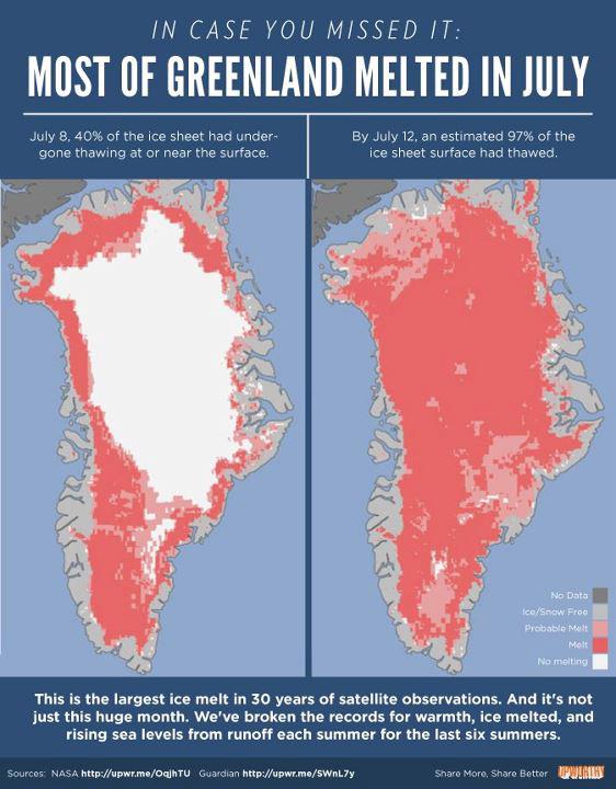
The ice sheet hasn't disappeared, this photo simply shows the amount of the cap that has undergone some sort of thawing in the summertime.
I'd hasten to add that most glaciers undergo thawing over quite a lot of their surface in the summertime. It's why we have RIVERS.
The ice sheet hasn't disappeared, this photo simply shows the amount of the cap that has undergone some sort of thawing in the summertime.
I'd hasten to add that most glaciers undergo thawing over quite a lot of their surface in the summertime. It's why we have RIVERS.
edit on
29-7-2012 by babybunnies because: (no reason given)
This topic has nothing to do with Obama, of whom I am not a fan either. Try and stay on topic.
sooo......
source 1
source 2
“A core from the CO2 firn-air sampling site at NEEM was retrieved in July 2009, and the physical properties of the firn have been analyzed. In the 81m of analyzed firn core, two regions containing ice layers were identified at depths of 29m and 46m. Isotopic analysis provides a depth-age scale that dates these layers to be from 1935 and 1879, respectively. These years were in the two warmest decades of the instrumental temperature record for Greenland.”
source 1
source 2
reply to post by babybunnies
While this isn't unheard of and it HAS happened before, it's exceptionally rare and the last recorded or known event similar was in 1889. Do I hear another 'Once in xxx year event' that has now added it self to the myriad of other ones to happen in a FEW year time frame?
it's not that any ONE event we see today is Earth shattering or unprecedented, it's that these are suppose to be once in a lifetime or even once in several. We arenb't supposed to be seeing back to back 150-500yr events in a few year stretch.
I know we're all tired and just sick to death of Global Warming this and Climate Change that. The little boy blowing false alarms must be about blue and ready to drop. However, while no reason for panic at all, this IS very noteworthy and ought to be remembered for context to future events, if nothing else, IMO.
While this isn't unheard of and it HAS happened before, it's exceptionally rare and the last recorded or known event similar was in 1889. Do I hear another 'Once in xxx year event' that has now added it self to the myriad of other ones to happen in a FEW year time frame?
it's not that any ONE event we see today is Earth shattering or unprecedented, it's that these are suppose to be once in a lifetime or even once in several. We arenb't supposed to be seeing back to back 150-500yr events in a few year stretch.
The thawed ice area jumped from 40% of the ice sheet to 97% in just four days from 8 July.
Although about half of Greenland's ice sheet normally sees surface melting over the summer months, the speed and scale of this year's thaw surprised scientists, who described the phenomenon as "extraordinary".
Nasa said that nearly the entire ice cover of Greenland, from its thin, low-lying coastal edges to its centre, which is 3km (two miles) thick, experienced some degree of melting at its surface.
Source
Dr Poul Christoffersen, a glaciologist and engineer at the Scott Polar Institute in Cambridge, told BBC News: "The melting seen in the satellite data is unprecedented, as it extends all the way across the ice sheet including the summit, which is located 3,200 m above sea level. Melting is usually limited to less than 2000m elevation."
I know we're all tired and just sick to death of Global Warming this and Climate Change that. The little boy blowing false alarms must be about blue and ready to drop. However, while no reason for panic at all, this IS very noteworthy and ought to be remembered for context to future events, if nothing else, IMO.
reply to post by Wrabbit2000
Actually as with the data I posted above, It happened in 1935, and indeed happens quite every so often.
Actually as with the data I posted above, It happened in 1935, and indeed happens quite every so often.
new topics
-
Bobiverse
Fantasy & Science Fiction: 19 minutes ago -
Florida man's trip overseas ends in shock over $143,000 T-Mobile phone bill
Social Issues and Civil Unrest: 24 minutes ago -
Former Labour minister Frank Field dies aged 81
People: 2 hours ago -
SETI chief says US has no evidence for alien technology. 'And we never have'
Aliens and UFOs: 4 hours ago -
This is our Story
General Entertainment: 6 hours ago -
President BIDEN Vows to Make Americans Pay More Federal Taxes in 2025 - Political Suicide.
2024 Elections: 9 hours ago -
Ode to Artemis
General Chit Chat: 10 hours ago
top topics
-
University student disciplined after saying veganism is wrong and gender fluidity is stupid
Education and Media: 17 hours ago, 14 flags -
President BIDEN Vows to Make Americans Pay More Federal Taxes in 2025 - Political Suicide.
2024 Elections: 9 hours ago, 12 flags -
Should Biden Replace Harris With AOC On the 2024 Democrat Ticket?
2024 Elections: 15 hours ago, 6 flags -
One Flame Throwing Robot Dog for Christmas Please!
Weaponry: 13 hours ago, 6 flags -
Don't take advantage of people just because it seems easy it will backfire
Rant: 14 hours ago, 4 flags -
Ditching physical money
History: 13 hours ago, 4 flags -
SETI chief says US has no evidence for alien technology. 'And we never have'
Aliens and UFOs: 4 hours ago, 4 flags -
Former Labour minister Frank Field dies aged 81
People: 2 hours ago, 3 flags -
Ode to Artemis
General Chit Chat: 10 hours ago, 3 flags -
This is our Story
General Entertainment: 6 hours ago, 2 flags
active topics
-
So this is what Hamas considers 'freedom fighting' ...
War On Terrorism • 250 • : FlyersFan -
President BIDEN Vows to Make Americans Pay More Federal Taxes in 2025 - Political Suicide.
2024 Elections • 26 • : network dude -
Russia Ukraine Update Thread - part 3
World War Three • 5725 • : BernnieJGato -
NASA Researchers Discover a Parallel Universe That Runs Backwards through Time - Alongside Us
Space Exploration • 70 • : seekshelter -
SETI chief says US has no evidence for alien technology. 'And we never have'
Aliens and UFOs • 21 • : network dude -
IDF Intel Chief Resigns Over Hamas attack
Middle East Issues • 43 • : TheWoker -
University student disciplined after saying veganism is wrong and gender fluidity is stupid
Education and Media • 44 • : confuzedcitizen -
Who guards the guards
US Political Madness • 6 • : covent -
Remember These Attacks When President Trump 2.0 Retribution-Justice Commences.
2024 Elections • 53 • : Justoneman -
Bobiverse
Fantasy & Science Fiction • 0 • : DAVID64