It looks like you're using an Ad Blocker.
Please white-list or disable AboveTopSecret.com in your ad-blocking tool.
Thank you.
Some features of ATS will be disabled while you continue to use an ad-blocker.

Indian Springs Auxiliary Airfields
page: 11
share:
I ran into this question while trying to figure out what the old WWII airfield at Groom Lake was called (Indian Springs Auxiliary Airfield #1 aka
Groom Lake Field). While looking into this I learned that Indian springs had a total of 5 auxiliary airfields, all but two, #1 (Groom Lake), and #4
(Pahute Mesa) are unaccounted for. I was curious if anyone has some info and locations for the missing ones, #2, #3 & #5?
List:
Indian Springs Airfield Auxiliary No. 1 - WWII Groom Lake Airfield
Indian Springs Airfield Auxiliary No. 2 - ?
Indian Springs Airfield Auxiliary No. 3 - Pahute Mesa Airfield, back in WWII it was also known as Forty-Mile Canyon Field.
Indian Springs Airfield Auxiliary No. 4 - ?
Indian Springs Airfield Auxiliary No. 5 - ?
edit on 7/18/2012 by DesertWatchdog because: (no reason given)
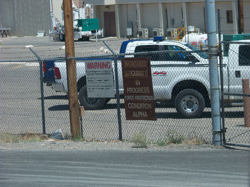
I don't know if you have ever been through Indian Springs, but I have, and there is still an active airfield right along the highway. Complete with
blue Mig jets and unmarked, flat black painted aircraft of varying sorts. Going through there on the way to Las Vegas always gave me the creeps.
Originally posted by SweetKarma
I don't know if you have ever been through Indian Springs, but I have, and there is still an active airfield right along the highway. Complete with blue Mig jets and unmarked, flat black painted aircraft of varying sorts. Going through there on the way to Las Vegas always gave me the creeps.
That's Creech AFB, formally Indian Springs Air Force Auxiliary Field. These auxiliary fields I'm talking about are satellite auxiliary fields of the former Indian Springs Aux. from WWII. Not much to be creeped out by. The MiGs are just mockups possibly of SU-27s.
www.lazygranch.com...
www.creech.af.mil...
en.wikipedia.org...
reply to post by DesertWatchdog
groups.yahoo.com...
This research sounds like a noble goal to me. The above link is for the yahoogroup that has the old maps. Also the University of Nevada website has some old maps.
Another good research project would be the use of the land along route 95 south of the main base. There are all sorts of ratty buildings in that area, perhaps for training exercises.
Originally posted by gariac
reply to post by DesertWatchdog
groups.yahoo.com...
This research sounds like a noble goal to me. The above link is for the yahoogroup that has the old maps. Also the University of Nevada website has some old maps.
Another good research project would be the use of the land along route 95 south of the main base. There are all sorts of ratty buildings in that area, perhaps for training exercises.
Unfortunately most of the maps the Nevada in Maps project are topo which list very few names and they don't have the right date range, 1940s-1944. I did note two new "Landing Strips" in a couple of 1950s topos that I was able to visually find in Google Earth. The old, original Yucca strip (not the one on the lake bed), and one on Gold Flat (not the target fields, but an actual "Landing Strip"). I'll get them posted after I finally get some sleep.
Unfortunately I had already checked Freemans data and he doesn't have anything listed for Indian Springs Aux Fields.
reply to post by DesertWatchdog
That looks like soviet migs purchased/acquired during and after coldwar
Linky
Linky
The MIGs or Sukoi at KINS are not actual aircraft. They are just photo targets. That is, a mockup.
I mentioned the yahoogroup to see if someone other than Friedman has data. For example, the map showing XSD at the TTR wasn't on the internet until I inquired at the forum.
Since these airports in question were never used by the public, you need the actual military maps. Maybe NARA at College Park Md. has information.
Originally posted by gariac
The MIGs or Sukoi at KINS are not actual aircraft. They are just photo targets. That is, a mockup.
I mentioned the yahoogroup to see if someone other than Friedman has data. For example, the map showing XSD at the TTR wasn't on the internet until I inquired at the forum.
Since these airports in question were never used by the public, you need the actual military maps. Maybe NARA at College Park Md. has information.
I got'cha. I'll make a post later tonight. You suppose if I were to call the PAO for Creech, Nellis or the Range, I would get a decent answer?
Originally posted by gariac
reply to post by DesertWatchdog
Another good research project would be the use of the land along route 95 south of the main base. There are all sorts of ratty buildings in that area, perhaps for training exercises.
I can't seem to spot what you're talking about.
reply to post by DesertWatchdog
I don't think all that crud along route 95 shows up well on google earth. You see it as you drive by. They could be Silver Flag Alpha related.
It never hurts to call the PAO, but it has been my experience that they are not historians. Even Shadowfax, who is the Edwards historian, doesn't have that as his job title. History doesn't seem to be a priority with the DoD.
If the airfield was built with civilian labor, you can FOIA to get the payment records. Then you know what firm built it, which in turn would yield construction documents.
You need to keep in mind that prior to the creation of the EPA by Nixon, the DoD just did what they wanted to do.
Speaking of environmental studies, the Desert Research Institute might be able to help you.
www.lazygranch.com...
I "clicked off" the USGS border for the Nellis range along route 95 and made the above link. Don't take this as gospel. [I keep meaning to bug the BLM and get the exact legal description of who own what.] I started at the edge of the road that leads into the Desert National Wildlife Refuge, certainly free territory.
Along route 95 within this border and south of Creech itself, there is all sorts of stuff. There doesn't seem to be much of a theme other than we own the land and need a place to do something.
The most visible area is starts at Point Bravo:
N36 32 04.9 W115 33 58.1
I've parked on the roadside mesas a few times and watched the "Capstone" and later "Firepower" demostrations done at Point Bravo. These were eventually dropped, probably due to expensive. Supposedly each event cost over a million. Then there was some fraud concerning the contract for the "jumbotron" leased at the event. Now the UGSG map says the USAF doesn't own Point Bravo, so clearly it isn't very up to date.
There is a base at
36.470634° -115.442814°
If you click through the Google Earth history, it has changed over the years, with 2006 being a year where it looks like the site was grubbed for new construction.
Here is a training track (obstacle course?) and another base:
36.474269° -115.454741°
A firing range (not to be confused with the range near Nellis itself):
36.479286° -115.456606°
Heading north, there are a few more ranges with large targets. Eventually you reach this facility:
36.504584° -115.490300°
Poles in the middle of a dry lake:
36.620483° -115.498240°
I doubt much of what goes on there is secret due to the proximity of route 95, but it would be nice to know exactly (as opposed to educated guesses) what goes on out there.
Originally posted by gariac
www.lazygranch.com...
I "clicked off" the USGS border for the Nellis range along route 95 and made the above link. Don't take this as gospel. [I keep meaning to bug the BLM and get the exact legal description of who own what.] I started at the edge of the road that leads into the Desert National Wildlife Refuge, certainly free territory.
Along route 95 within this border and south of Creech itself, there is all sorts of stuff. There doesn't seem to be much of a theme other than we own the land and need a place to do something.
The most visible area is starts at Point Bravo:
N36 32 04.9 W115 33 58.1
I've parked on the roadside mesas a few times and watched the "Capstone" and later "Firepower" demostrations done at Point Bravo. These were eventually dropped, probably due to expensive. Supposedly each event cost over a million. Then there was some fraud concerning the contract for the "jumbotron" leased at the event. Now the UGSG map says the USAF doesn't own Point Bravo, so clearly it isn't very up to date.
There is a base at
36.470634° -115.442814°
If you click through the Google Earth history, it has changed over the years, with 2006 being a year where it looks like the site was grubbed for new construction.
Here is a training track (obstacle course?) and another base:
36.474269° -115.454741°
A firing range (not to be confused with the range near Nellis itself):
36.479286° -115.456606°
Heading north, there are a few more ranges with large targets. Eventually you reach this facility:
36.504584° -115.490300°
Poles in the middle of a dry lake:
36.620483° -115.498240°
I doubt much of what goes on there is secret due to the proximity of route 95, but it would be nice to know exactly (as opposed to educated guesses) what goes on out there.
One of the locations I believe you are talking about...?
Expeditionary Readiness Training
(ExpeRT) Course Expansion
Final Environmental Assessment
www.nellis.af.mil...
reply to post by DesertWatchdog
On page 19 of the pdf, there is a map showing the location of the proposed project. Where it reads "existing MOUT village" corresponds to
36.473362° -115.441695° .
Note the map in the pdf is skewed a bit, i.e. what should be north on the pdf map is actually north-east. The "existing control tower" could be at
36.471760° -115.440719°
with the hangars centered at
36.471493° -115.440526° .
One hangar has its covering removed.
I think this proposed modifications never got built, or it was built then torn down.
The traffic circle at
36.477195° -115.444626°
looks suspicious. First of all, how could this area have enough traffic to warrant a traffic circle. A simple 4 way would do. Traffic circles are used to maintain traffic flow (i.e. don't stop) while conserving real estate (as opposed to a clover leaf). I would say this traffic circle is there for training purposes. There appears to be a roadblock at
36.475290° -115.443135° .
Originally posted by gariac
www.lazygranch.com...
I "clicked off" the USGS border for the Nellis range along route 95 and made the above link. Don't take this as gospel. [I keep meaning to bug the BLM and get the exact legal description of who own what.] I started at the edge of the road that leads into the Desert National Wildlife Refuge, certainly free territory.
Along route 95 within this border and south of Creech itself, there is all sorts of stuff. There doesn't seem to be much of a theme other than we own the land and need a place to do something.
The most visible area is starts at Point Bravo:
N36 32 04.9 W115 33 58.1
I've parked on the roadside mesas a few times and watched the "Capstone" and later "Firepower" demostrations done at Point Bravo. These were eventually dropped, probably due to expensive. Supposedly each event cost over a million. Then there was some fraud concerning the contract for the "jumbotron" leased at the event. Now the UGSG map says the USAF doesn't own Point Bravo, so clearly it isn't very up to date.
There is a base at
36.470634° -115.442814°
If you click through the Google Earth history, it has changed over the years, with 2006 being a year where it looks like the site was grubbed for new construction.
Here is a training track (obstacle course?) and another base:
36.474269° -115.454741°
A firing range (not to be confused with the range near Nellis itself):
36.479286° -115.456606°
Heading north, there are a few more ranges with large targets. Eventually you reach this facility:
36.504584° -115.490300°
Poles in the middle of a dry lake:
36.620483° -115.498240°
I doubt much of what goes on there is secret due to the proximity of route 95, but it would be nice to know exactly (as opposed to educated guesses) what goes on out there.
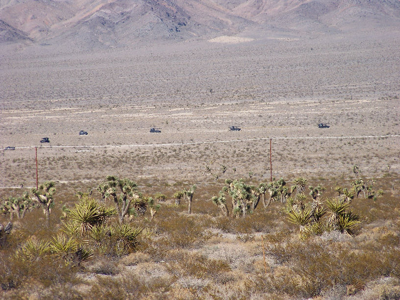
Found some pics I took in 2009 of these "facilities" along route 95, as I also saw them on GE and it peaked my interest. "Here is a training track (obstacle course?) and another base 36.474269° -115.454741°":
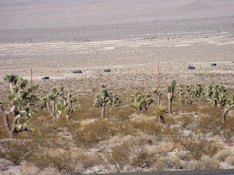
This one I believe is located here:
36°30'15.69"N, 115°29'26.54"W

And this one I believe is here:
36°30'19.17"N, 115°29'31.39"W

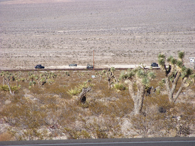
"Point Bravo" as gariac describes in his post. These were taken earlier this year, first week of June.
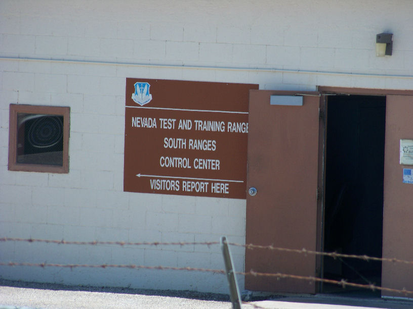
Not sure what exactly this place is - it is referenced in a few places as a "logistics site", and marked as the "NTTR South Ranges Control Center".
36°32'4.75"N, 115°33'57.21"W
The range at Point Bravo (63) gets bombed often. I could see Nellis needing a point of presence there to control access, given the proximity to the
highway. (Translation: watch out for yahoos) There is also the issue of DU rounds. You don't want souvenir hunting out there. I think only the A-10s
are shooting DU.
You could get quite a show out there when the bomb. I've watched it from Tikaboo, so all you see is the flash of light on the other side of the mountain range. The illumination flares are quite visible from Tikaboo. Probably from the ET highway as well.
If you never saw one, an illumination flare is a flare plus parachute combination. The heat from the flare rises into the parachute, so they stay in place for minutes. These are the "orbs" seen on the range.
There is an artillery shell version of the illumination flare used by land forces. Apparently these shells would occasionally end up in IEDs. The convoy would trip the IED and a parachute gets launched.
It wouldn't surprise me if there is a fire department building at Point Bravo, or maybe they bring one in from Creech during live fire exercises.
Nellis uses Point Bravo as a radio relay point to Angels Peak. You can't miss the dishes.
The term "fatness 63" shows up in Nellis documents for radio on that part of the range.
Originally posted by DesertWatchdog
I ran into this question while trying to figure out what the old WWII airfield at Groom Lake was called (Indian Springs Auxiliary Airfield #1 aka Groom Lake Field). While looking into this I learned that Indian springs had a total of 5 auxiliary airfields, all but two, #1 (Groom Lake), and #4 (Pahute Mesa) are unaccounted for. I was curious if anyone has some info and locations for the missing ones, #2, #3 & #5?
List:
Indian Springs Airfield Auxiliary No. 1 - WWII Groom Lake Airfield
Indian Springs Airfield Auxiliary No. 2 - ?
Indian Springs Airfield Auxiliary No. 3 - Pahute Mesa Airfield, back in WWII it was also known as Forty-Mile Canyon Field.
Indian Springs Airfield Auxiliary No. 4 - ?
Indian Springs Airfield Auxiliary No. 5 - ?
Ignore. Guess I should try reading ALL the posts in a thread before I blather.
EDITED TO ADD:
"While looking into this I learned that Indian springs had a total of 5 auxiliary airfields"
Where exactly did you come across this info? On the web?
edit on 22-7-2012 by FosterVS because: (no reason given)
new topics
-
Sunak spinning the sickness figures
Other Current Events: 2 minutes ago -
Nearly 70% Of Americans Want Talks To End War In Ukraine
Political Issues: 13 minutes ago -
Late Night with the Devil - a really good unusual modern horror film.
Movies: 2 hours ago -
Cats Used as Live Bait to Train Ferocious Pitbulls in Illegal NYC Dogfighting
Social Issues and Civil Unrest: 3 hours ago -
The Good News According to Jesus - Episode 1
Religion, Faith, And Theology: 5 hours ago -
HORRIBLE !! Russian Soldier Drinking Own Urine To Survive In Battle
World War Three: 7 hours ago -
Bobiverse
Fantasy & Science Fiction: 10 hours ago -
Florida man's trip overseas ends in shock over $143,000 T-Mobile phone bill
Social Issues and Civil Unrest: 10 hours ago
top topics
-
Florida man's trip overseas ends in shock over $143,000 T-Mobile phone bill
Social Issues and Civil Unrest: 10 hours ago, 8 flags -
SETI chief says US has no evidence for alien technology. 'And we never have'
Aliens and UFOs: 14 hours ago, 7 flags -
Cats Used as Live Bait to Train Ferocious Pitbulls in Illegal NYC Dogfighting
Social Issues and Civil Unrest: 3 hours ago, 7 flags -
This is our Story
General Entertainment: 16 hours ago, 4 flags -
Former Labour minister Frank Field dies aged 81
People: 12 hours ago, 4 flags -
Bobiverse
Fantasy & Science Fiction: 10 hours ago, 3 flags -
Late Night with the Devil - a really good unusual modern horror film.
Movies: 2 hours ago, 2 flags -
HORRIBLE !! Russian Soldier Drinking Own Urine To Survive In Battle
World War Three: 7 hours ago, 2 flags -
The Good News According to Jesus - Episode 1
Religion, Faith, And Theology: 5 hours ago, 0 flags -
Nearly 70% Of Americans Want Talks To End War In Ukraine
Political Issues: 13 minutes ago, 0 flags
active topics
-
Nearly 70% Of Americans Want Talks To End War In Ukraine
Political Issues • 2 • : Consvoli -
President BIDEN Vows to Make Americans Pay More Federal Taxes in 2025 - Political Suicide.
2024 Elections • 104 • : ImagoDei -
Sunak spinning the sickness figures
Other Current Events • 0 • : annonentity -
British TV Presenter Refuses To Use Guest's Preferred Pronouns
Education and Media • 144 • : Consvoli -
Cats Used as Live Bait to Train Ferocious Pitbulls in Illegal NYC Dogfighting
Social Issues and Civil Unrest • 9 • : ImagoDei -
Late Night with the Devil - a really good unusual modern horror film.
Movies • 3 • : Hecate666 -
HORRIBLE !! Russian Soldier Drinking Own Urine To Survive In Battle
World War Three • 23 • : Disgusted123 -
Hi folks I'm Leon Grad
Introductions • 9 • : leongrad -
The Reality of the Laser
Military Projects • 41 • : 5thHead -
Thousands Of Young Ukrainian Men Trying To Flee The Country To Avoid Conscription And The War
Other Current Events • 136 • : NorthOS
1