It looks like you're using an Ad Blocker.
Please white-list or disable AboveTopSecret.com in your ad-blocking tool.
Thank you.
Some features of ATS will be disabled while you continue to use an ad-blocker.

ATS Exclusive- Could Deep Well Injection Trigger a 7+ Earthquake?
page: 1share:
In Northern California, I believe it may be possible that it could. And beyond just mere speculation, in this thread I intend to show, using USGS and
other scientific data, how this could be entirely possible.
My own research into this started out innocently when I obtained a recent quakes application for Google Earth (GE), sourced directly from the USGS. You can find that app here:
earthquake.usgs.gov...
This provides an auto-updating kml feed of USGS recent quakes, soon after they are reported by them.
I've been using GE a lot more lately, and have built it up specifically as a tool to aid my quake watching experience and further seismology studies, as many on ATS already know I enjoy doing as a hobby. Yippee, and I even passed a CAL State University basic seismology assessment test with 100% accuracy, so I feel like I am making steady progress. Made a thread about that Here at ATS, and encourage anyone interested to take it too. It's fun!
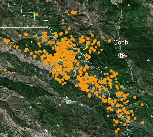
But let's get right down to it. Just browsing around, taking a look at recent seismic activity in GE, I spotted this seemingly innocent swarm of earthquakes in Northern California:
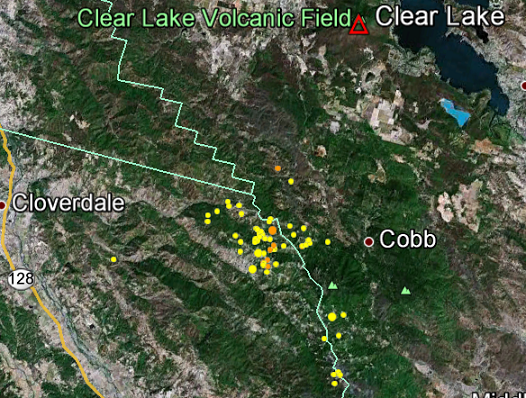
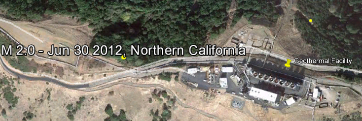
Upon a closer look, however, I noticed and recognized, from some recent research I had done about one right in the Long Valley Caldera- a geothermal facility very close to these quakes. This is what a part of one looks like:
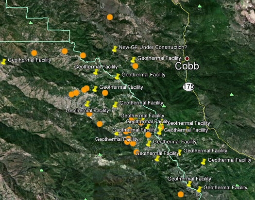
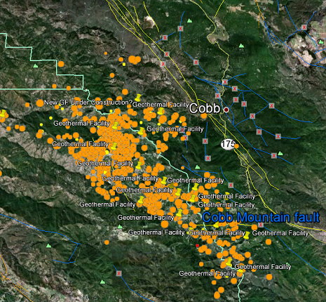
So I went looking around the area a lot more, discovered tons of them, and took the time to placemark most of them, until I was pretty satisfied that this was a geothermal development area, so there are even more than than shown here, and more subproperties of the development not placemarked too. Just look around for yourself if you like in GE or maps, but here's pic so you can get an idea:
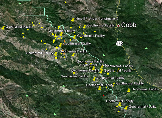
Yes, the dots are recent quakes, and the pins are my placemarks of geothermal facilities. Starting to see a pattern here? Good, read on because this gets worse. A lot worse.
After looking into it further, turns out this is The Geysers area, the biggest geothermal development in the world, which produces more power than any other. They extract heat from the Clear Lake Volcanic field, which just happens to be #1 on the USGS's list of the most hazardous volcanoes they are concerned about:
volcanoes.usgs.gov...
Scroll to bottom right to see that
Now we already know that deep well injection, also used by the geothermal energy extraction process, has been known to cause smaller earthquakes, as this topic has come about many times before at ATS. But I had no idea that it occurs to extent I am about to show you.
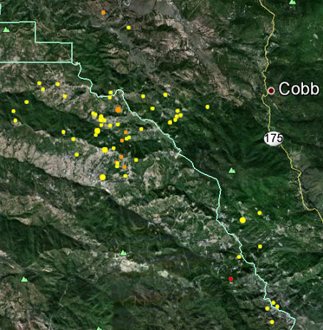
This is a pic of the earthquakes that have occurred in that area JUST IN THE LAST WEEK, sourced from the USGS recent quakes app linked above:
But I had also recently downloaded the entire USGS quake catalog in Google Earth files, back to 1973. So I was curious what would happen if I enabled those layers over this area. Well to make a long story short, I was only able to load into GE those kmls files going back to 1998, because GE kept crashing after that. So yeah, I am talking about having to build this up, losing the myplaces.kml many times, constant crashes, and a lot of work. So I am just giving you what I can here, but I think you will get the idea rather quickly. This is what happened when I overlayed all quakes from 1998-2012, about 14 years of quake data:
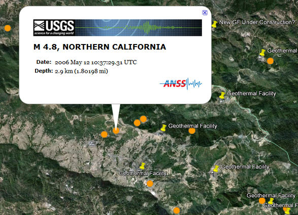
So I clicked around on these quakes, viewing their info, and discovered something else. There are many 4+ magnitude quakes in there, and all of them are shallow quakes, less than 10 km deep. In fact nearly all of them are less than 5 km deep, and probably 80% or more are less than 3 km deep. So in my mind, there is no question they are being caused by the well injection. But since when are 4+ quakes caused by well injection nothing to worry about? I thought only tiny quakes were produced by this process! So then I removed all the 3 mag and below, and produced this pic of JUST the 4.0+ magnitude quakes that have happened there since 1998, along with the GF layer:
And one of them reached 4.8!:
But wait, I thought a certain amount of fault area rupture area had to occur before you could get a quake that big? So I looked into that exact thing further, and found this scientific study, which documents magnitudes and fault length ruptures, so you can see how much fault area it takes to rupture for various size earthquakes, mostly above 5 mag. And they list both Ms and Mw, including surface, subsurface and fault width, for the more technically inclined reader, of actual earthquakes that have occurred all over the world. I tried to concentrate my focus on California earthquakes in that data, seeing as we are talking about Northern Cali here.
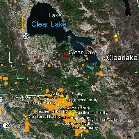
But heck, just look at the bigger picture now when I put back in the placemarks and zoom out a bit, this is what we are dealing with, including most everything:
Any questions?
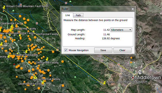
Yeah, I have another. *raises hand* So just how close to any known faults is all this going on, causing all those earthquakes? Well, you could always download USGS's KML Fault files for GE, and be content with that. Just doing that alone I discovered that all this is going on next to a dormant fault, the Cobb Mountain Fault:
And measuring that, found out it was about 11.4 km long. Comparing that alone to the data provided in the scientific doc, a triggered fault rupture from all that injection seismicity so close to it has the potential to cause a 5.5 to 6.5 quake by itself! :shk: See the fault length measurement yourself:
Ok, so at this point in my research, a little startled, I wanted to be sure I was getting all the faults listed, and so I checked some other sources, and amazingly came up with another, more comprehensive USGS fault list from the mineral resources dept. Now why all these other faults are not included in the first KML's linked is a mystery in itself. I don't know. Or maybe now I do. Because get this- when I overlayed THIS data on top of what I already had and started clicking around, I found this:
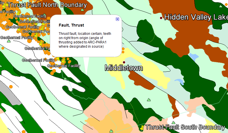
A darn THRUST FAULT GOING RIGHT DOWN THE MIDDLE of all that geothermal extraction! :shk: Man! I couldn't BELIEVE they'd do this!
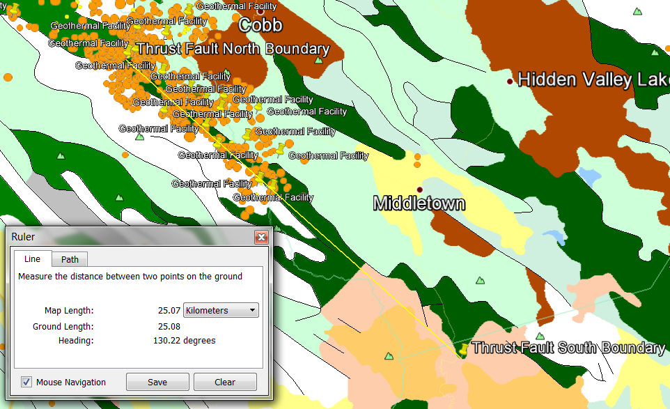
They built all this, right down on top of a dangerous thrust fault. Straight line measurement: 25 km, but total rupture possible: Over 40 km. Quake size potential: 7+ from triggered seismicity.
So I am done. You decide for yourselves what can happen. But this took FOREVER, and is definitely the most original research and work I have ever done on an ATS thread.
My own research into this started out innocently when I obtained a recent quakes application for Google Earth (GE), sourced directly from the USGS. You can find that app here:
earthquake.usgs.gov...
This provides an auto-updating kml feed of USGS recent quakes, soon after they are reported by them.
I've been using GE a lot more lately, and have built it up specifically as a tool to aid my quake watching experience and further seismology studies, as many on ATS already know I enjoy doing as a hobby. Yippee, and I even passed a CAL State University basic seismology assessment test with 100% accuracy, so I feel like I am making steady progress. Made a thread about that Here at ATS, and encourage anyone interested to take it too. It's fun!
But let's get right down to it. Just browsing around, taking a look at recent seismic activity in GE, I spotted this seemingly innocent swarm of earthquakes in Northern California:
Upon a closer look, however, I noticed and recognized, from some recent research I had done about one right in the Long Valley Caldera- a geothermal facility very close to these quakes. This is what a part of one looks like:
So I went looking around the area a lot more, discovered tons of them, and took the time to placemark most of them, until I was pretty satisfied that this was a geothermal development area, so there are even more than than shown here, and more subproperties of the development not placemarked too. Just look around for yourself if you like in GE or maps, but here's pic so you can get an idea:
Yes, the dots are recent quakes, and the pins are my placemarks of geothermal facilities. Starting to see a pattern here? Good, read on because this gets worse. A lot worse.
After looking into it further, turns out this is The Geysers area, the biggest geothermal development in the world, which produces more power than any other. They extract heat from the Clear Lake Volcanic field, which just happens to be #1 on the USGS's list of the most hazardous volcanoes they are concerned about:
volcanoes.usgs.gov...
Scroll to bottom right to see that
Now we already know that deep well injection, also used by the geothermal energy extraction process, has been known to cause smaller earthquakes, as this topic has come about many times before at ATS. But I had no idea that it occurs to extent I am about to show you.
This is a pic of the earthquakes that have occurred in that area JUST IN THE LAST WEEK, sourced from the USGS recent quakes app linked above:
But I had also recently downloaded the entire USGS quake catalog in Google Earth files, back to 1973. So I was curious what would happen if I enabled those layers over this area. Well to make a long story short, I was only able to load into GE those kmls files going back to 1998, because GE kept crashing after that. So yeah, I am talking about having to build this up, losing the myplaces.kml many times, constant crashes, and a lot of work. So I am just giving you what I can here, but I think you will get the idea rather quickly. This is what happened when I overlayed all quakes from 1998-2012, about 14 years of quake data:
So I clicked around on these quakes, viewing their info, and discovered something else. There are many 4+ magnitude quakes in there, and all of them are shallow quakes, less than 10 km deep. In fact nearly all of them are less than 5 km deep, and probably 80% or more are less than 3 km deep. So in my mind, there is no question they are being caused by the well injection. But since when are 4+ quakes caused by well injection nothing to worry about? I thought only tiny quakes were produced by this process! So then I removed all the 3 mag and below, and produced this pic of JUST the 4.0+ magnitude quakes that have happened there since 1998, along with the GF layer:
And one of them reached 4.8!:
But wait, I thought a certain amount of fault area rupture area had to occur before you could get a quake that big? So I looked into that exact thing further, and found this scientific study, which documents magnitudes and fault length ruptures, so you can see how much fault area it takes to rupture for various size earthquakes, mostly above 5 mag. And they list both Ms and Mw, including surface, subsurface and fault width, for the more technically inclined reader, of actual earthquakes that have occurred all over the world. I tried to concentrate my focus on California earthquakes in that data, seeing as we are talking about Northern Cali here.
But heck, just look at the bigger picture now when I put back in the placemarks and zoom out a bit, this is what we are dealing with, including most everything:
Any questions?
Yeah, I have another. *raises hand* So just how close to any known faults is all this going on, causing all those earthquakes? Well, you could always download USGS's KML Fault files for GE, and be content with that. Just doing that alone I discovered that all this is going on next to a dormant fault, the Cobb Mountain Fault:
And measuring that, found out it was about 11.4 km long. Comparing that alone to the data provided in the scientific doc, a triggered fault rupture from all that injection seismicity so close to it has the potential to cause a 5.5 to 6.5 quake by itself! :shk: See the fault length measurement yourself:
Ok, so at this point in my research, a little startled, I wanted to be sure I was getting all the faults listed, and so I checked some other sources, and amazingly came up with another, more comprehensive USGS fault list from the mineral resources dept. Now why all these other faults are not included in the first KML's linked is a mystery in itself. I don't know. Or maybe now I do. Because get this- when I overlayed THIS data on top of what I already had and started clicking around, I found this:
A darn THRUST FAULT GOING RIGHT DOWN THE MIDDLE of all that geothermal extraction! :shk: Man! I couldn't BELIEVE they'd do this!
Large overthrust faults occur in areas that have undergone great compressional forces.
They built all this, right down on top of a dangerous thrust fault. Straight line measurement: 25 km, but total rupture possible: Over 40 km. Quake size potential: 7+ from triggered seismicity.
So I am done. You decide for yourselves what can happen. But this took FOREVER, and is definitely the most original research and work I have ever done on an ATS thread.
edit on Fri Jul 6th 2012 by TrueAmerican because: (no reason given)
Well, it's a lot to look at and I'm sure it'll be a good read.
For right now I have to SnF for the effort, time and all the pretty pictures!
I'll be back but wanted to thank you for this and...Yes...something is cooking out there. I agree.
Peace
For right now I have to SnF for the effort, time and all the pretty pictures!
I'll be back but wanted to thank you for this and...Yes...something is cooking out there. I agree.
Peace
reply to post by jude11
Thanks, and I am still digesting this all and thinking it over more. Some might argue that no way could surface seismicity trigger a deeper fault rupture, and I would imagine that probably had a part in their decision to build on it anyway. But now that Japan has happened, in the way that it did, and not knowing just WHAT, ALL THAT SEISMICITY is doing to the crust below, repeatedly pounding that dangerous fault into oblivion, I just wonder what may be in store down the road. Japan was a surprise, and a 4.8 triggered from geothermal is right there in our faces.
But that fault right there in the middle of it all is taking another chance, just the same way the 9.0 in Japan proved to be too much, for the nuclear chance Japan took- and lost. Thats just too many darned triggered quakes, getting too big, on a dangerous fault, and near a nasty volcano, #1 on the USGS hazard list. You'd think some people would know better, and Middletown might just find that out the hard way one day.
edit on Fri Jul 6th
2012 by TrueAmerican because: (no reason given)
Fand S.
What do you know about Signal Hill and Long Beach ?
Is it true, after pumping out oil they filled the gaps with sea water ?
What do you know about Signal Hill and Long Beach ?
Is it true, after pumping out oil they filled the gaps with sea water ?
And I haven't even gotten to the part of where they are considering this for Yellowstone. Fortunately, because YS is a protected US National Park,
they haven't managed yet. At least not right in the park itself, but in Montana close by, and arguably part of the same system, they have all kinds
of geothermal development.
Big Energy has a lot of money. And as we know, that can have a major affect on things like politicians to find or make loopholes. Or pass new laws altogether. And I found at least one article where they already appear to be conditioning students to entertain the idea, and having students debate it. For the long term, you bet your nippies they want into Yellowstone.
Big Energy has a lot of money. And as we know, that can have a major affect on things like politicians to find or make loopholes. Or pass new laws altogether. And I found at least one article where they already appear to be conditioning students to entertain the idea, and having students debate it. For the long term, you bet your nippies they want into Yellowstone.
reply to post by TrueAmerican
Awesome thread man.
It's absurd that they would do all that fracking there, Come on. They are just asking for trouble.
I'm going to break this down in a simple analogy for those that will have trouble processing all that info.
Imagine a camper banging stakes into a tree to set up a hammock, the banging pissed off the Wasps living in the tree and the Badger living under it. Oh, and you just woke up the hibernating Grizzly Bear in the cave behind you.
S and F for the well put together thread.
Will keep coming back to this thread as it developes.
Will keep coming back to this thread as it developes.
Originally posted by watchitburn
reply to post by TrueAmerican
Oh, and you just woke up the hibernating Grizzly Bear in the cave behind you.
Exactly. And sometimes they wake up on their own. But it's a sticky situation no matter how you slice it, because geologists and/or seismologists employed by Big Energy could always use the fact that there is a known thrust fault there as an excuse for a big quake if it occurred, arguing that the shallower seismicity couldn't have triggered it. If the depth of the big quake were to play into their favor at over 35km depth, they might have a tough case to beat. But if it occurred at 20 km depth or less, and close enough to the development that it was clear they caused it, and a boatload of damage and death ensued, Big USA Energy could face a severe backlash and a heap of lawsuits.
But if it happened residents could also argue that the fault has not shown activity much in the last 15,000 years. Or has it? While the scientists could say that these current quakes are caused by "earth subsidence and inflation from the fluid flow of the injection process," do they really know how all these quakes are affecting that fault? Is it the fault itself responding to this human breach of the earth's natural process?
There's no question this is complicated, and even more so if you start to bring the actual focal mechanisms of these shallow quakes into the argument. That will involve deeper study for me, and I haven't checked on that yet. Would need to consult just the right person for that- and someone I can trust. And I might know just such a person to talk to.
Just wondering when all those geothermal stations were built and then getting more quake data over a similar time frame before the
geothermal stations were constructed, it will further prove your case or disprove it.
Don't think I do not appreaciate your threads, they are always well constructed, always give me the willys but have not panned out yet (to my knowledge)
Don't think I do not appreaciate your threads, they are always well constructed, always give me the willys but have not panned out yet (to my knowledge)
edit on 7-7-2012 by Qumulys because: (no reason given)
you worked hard, collected a lot of good info , it's an interesting subject for sure...will keep an eye on this
reply to post by TrueAmerican
Nice Try, but if you actually lived and worked in the oil field, you would realize that it just won't happen.
Nice Try, but if you actually lived and worked in the oil field, you would realize that it just won't happen.
Originally posted by Labrynth2012
reply to post by TrueAmerican
Nice Try, but if you actually lived and worked in the oil field, you would realize that it just won't happen.
care to elaborate?? why wouldn't it happen? seems pretty plausible.
Before I read this thread..I was reading a thread about the focus on terriost threats at the Olympics but really it's just a diversion and the real
catastrophe happens somewhere else. After reading this thread I got dejuva....A feeling of something bad happened to CA and feeling concerned about it
at the time I'm to go on vacation in Aug. I'm hoping this feeling of dejuva is a false feeling due to my insecurity about our future...
Wow, well thought out and informative post! I also would like to see when the geothermal stations were built up against data from before and after.
Kudos, OP! Very, very interesting.
Kudos, OP! Very, very interesting.
Originally posted by samara11278
Wow, well thought out and informative post! I also would like to see when the geothermal stations were built up against data from before and after.
Sounds like a great project for you to tackle!
I've been watching quakes long enough to pretty well bet you all that seismicity is being caused by the development. And if someone can show that there was that much activity there before the construction began, I'd be amazed.
I mean look at the rate of these earthquakes here:
earthquake.usgs.gov...
But to partly, and mostly, answer the question, I am loading the years prior to 98 into GE, and checking for earthquakes in the same area. So far, starting with 1973, there's hardly anything there at all. I am still checking on this, but those earlier years look NOTHING what we are seeing now. But that could be due to lack of instruments placed there at the time. I know there are questions, gotta give me more time, or someone jump in and help me.
And you know what is really curious is that the USGS keeps publishing them. I'll bet also that this much seismic activity there is also concerning at least a few scientists at the USGS.
At least from USGS quake records, it appears that seismicity started as early as 1981 there. But that is just the USGS records, which get less
comprehensive the older they go. There were less instruments in those days.
And what is curious is that corresponds roughly to the same time period after they started injection:
www.geysers.com...
As early as 1960, as you can see from the link, they started development. So what probably happened is that earthquakes were happening there, but were not getting recorded until later, like the early 80's, when instruments went in. That would be my best guess. Records are available from seismic networks when the stations went in, so that is another avenue of research, yet to be done.
And what is curious is that corresponds roughly to the same time period after they started injection:
1970- The Geothermal Resources Council is formed to encourage the development of geothermal resources worldwide. In the United States the Geothermal Steam Act is enacted providing the Secretary of the Interior with the authority to lease public lands and other federal lands for geothermal exploration and development in an environmentally sound manner. Recycling of spent geothermal fluids back into the production zone begins as a means to dispose of wastewater and maintain reservoir life.
www.geysers.com...
As early as 1960, as you can see from the link, they started development. So what probably happened is that earthquakes were happening there, but were not getting recorded until later, like the early 80's, when instruments went in. That would be my best guess. Records are available from seismic networks when the stations went in, so that is another avenue of research, yet to be done.
Earthquake activity:
Middletown-area historical earthquake activity is slightly above California state average. It is 1976% greater than the overall U.S. average.
On 4/18/1906 at 13:12:21, a magnitude 7.9 (7.9 UK, Class: Major, Intensity: VIII - XII) earthquake occurred 56.1 miles away from the city center, causing $524,000,000 total damage
On 1/24/1980 at 19:00:09, a magnitude 5.9 (5.3 MB, 5.9 MS, 5.8 MW, 5.5 ML, Class: Moderate, Intensity: VI - VII) earthquake occurred 86.7 miles away from Middletown center
On 8/1/1975 at 20:20:12, a magnitude 5.8 (5.8 MB, 5.6 MS, 5.8 MW, 5.7 ML) earthquake occurred 83.5 miles away from the city center
On 1/27/1980 at 02:33:36, a magnitude 5.8 (5.0 MB, 5.0 MS, 5.8 ML) earthquake occurred 84.9 miles away from the city center
On 9/3/2000 at 08:36:30, a magnitude 5.2 (4.9 MB, 4.9 MS, 5.2 ML, 5.0 MW, Depth: 6.3 mi) earthquake occurred 28.1 miles away from Middletown center, causing $50,000,000 total damage
On 9/19/1992 at 23:04:47, a magnitude 4.9 (4.5 MB, 4.5 ML, 4.9 ML, Depth: 1.2 mi, Class: Light, Intensity: IV - V) earthquake occurred 12.2 miles away from the city center
www.city-data.com...
And there's the ace in the hole for Big Energy. Big quakes have occurred before there, and before there was any geothermal development. And look at some of the depths of those. Shallow. Yup, they've got all the ammunition they need to keep right on keeping on.
Come on, who would not think fracturing the earths crust wouldn't lead to bigger fault zones releasing their pressure as the cracks from fracking
came into contact with the fault zones. These small fisures created by fracking will migrate towards larger cracks by the virtue of the already broken
and either sagging or uplifting crust. Fracking is used to allow liquids to migrate to well holes. A byproduct of migrating liquid is that the weight
it supported is no longer supported, it either hangs as a rigid structure or it sinks. Either way, stress cracks form.
Well, got some news about this from my professional contacts, who have seen my data, and they are ASSURING me that Yellowstone National Park has a
"zero tolerance" policy against geothermal exploitation. They are telling me that geothermal development will never happen anywhere near YS.

And that is one piece of news I am extremely happy to report to you.
And that is one piece of news I am extremely happy to report to you.
Originally posted by Plotus
Come on, who would not think fracturing the earths crust wouldn't lead to bigger fault zones releasing their pressure as the cracks from fracking came into contact with the fault zones. These small fisures created by fracking will migrate towards larger cracks by the virtue of the already broken and either sagging or uplifting crust. Fracking is used to allow liquids to migrate to well holes. A byproduct of migrating liquid is that the weight it supported is no longer supported, it either hangs as a rigid structure or it sinks. Either way, stress cracks form.
Obviously, you don't know any Geologists or people who work in the oil field and if you did, you would not be making this kind of remarks. Fracking takes place in a HORIZONTAL manner, not VERTICAL. Also, its not deep enough to displace anything or cause such displacements. It is the ignorance of people who are unfamiliar with the oil industry that don't have a clue about what does what or how things work.
new topics
-
Las Vegas UFO Spotting Teen Traumatized by Demon Creature in Backyard
Aliens and UFOs: 3 hours ago -
2024 Pigeon Forge Rod Run - On the Strip (Video made for you)
Automotive Discussion: 4 hours ago -
Gaza Terrorists Attack US Humanitarian Pier During Construction
Middle East Issues: 4 hours ago -
The functionality of boldening and italics is clunky and no post char limit warning?
ATS Freshman's Forum: 5 hours ago -
Meadows, Giuliani Among 11 Indicted in Arizona in Latest 2020 Election Subversion Case
Mainstream News: 6 hours ago -
Massachusetts Drag Queen Leads Young Kids in Free Palestine Chant
Social Issues and Civil Unrest: 6 hours ago -
Weinstein's conviction overturned
Mainstream News: 7 hours ago -
Supreme Court Oral Arguments 4.25.2024 - Are PRESIDENTS IMMUNE From Later Being Prosecuted.
Above Politics: 9 hours ago -
Krystalnacht on today's most elite Universities?
Social Issues and Civil Unrest: 9 hours ago -
Chris Christie Wishes Death Upon Trump and Ramaswamy
Politicians & People: 9 hours ago
top topics
-
Krystalnacht on today's most elite Universities?
Social Issues and Civil Unrest: 9 hours ago, 9 flags -
Supreme Court Oral Arguments 4.25.2024 - Are PRESIDENTS IMMUNE From Later Being Prosecuted.
Above Politics: 9 hours ago, 8 flags -
Weinstein's conviction overturned
Mainstream News: 7 hours ago, 7 flags -
University of Texas Instantly Shuts Down Anti Israel Protests
Education and Media: 11 hours ago, 6 flags -
Massachusetts Drag Queen Leads Young Kids in Free Palestine Chant
Social Issues and Civil Unrest: 6 hours ago, 5 flags -
Gaza Terrorists Attack US Humanitarian Pier During Construction
Middle East Issues: 4 hours ago, 5 flags -
Meadows, Giuliani Among 11 Indicted in Arizona in Latest 2020 Election Subversion Case
Mainstream News: 6 hours ago, 5 flags -
Las Vegas UFO Spotting Teen Traumatized by Demon Creature in Backyard
Aliens and UFOs: 3 hours ago, 3 flags -
Chris Christie Wishes Death Upon Trump and Ramaswamy
Politicians & People: 9 hours ago, 2 flags -
2024 Pigeon Forge Rod Run - On the Strip (Video made for you)
Automotive Discussion: 4 hours ago, 2 flags
active topics
-
University of Texas Instantly Shuts Down Anti Israel Protests
Education and Media • 200 • : cherokeetroy -
Chris Christie Wishes Death Upon Trump and Ramaswamy
Politicians & People • 21 • : WhitewaterSquirrel -
Meadows, Giuliani Among 11 Indicted in Arizona in Latest 2020 Election Subversion Case
Mainstream News • 12 • : Boomer1947 -
-@TH3WH17ERABB17- -Q- ---TIME TO SHOW THE WORLD--- -Part- --44--
Dissecting Disinformation • 683 • : MetalThunder -
Supreme Court Oral Arguments 4.25.2024 - Are PRESIDENTS IMMUNE From Later Being Prosecuted.
Above Politics • 78 • : chr0naut -
The Acronym Game .. Pt.3
General Chit Chat • 7750 • : bally001 -
Las Vegas UFO Spotting Teen Traumatized by Demon Creature in Backyard
Aliens and UFOs • 7 • : rickymouse -
University student disciplined after saying veganism is wrong and gender fluidity is stupid
Education and Media • 50 • : watchitburn -
VP's Secret Service agent brawls with other agents at Andrews
Mainstream News • 55 • : CarlLaFong -
Cats Used as Live Bait to Train Ferocious Pitbulls in Illegal NYC Dogfighting
Social Issues and Civil Unrest • 23 • : Ravenwatcher