It looks like you're using an Ad Blocker.
Please white-list or disable AboveTopSecret.com in your ad-blocking tool.
Thank you.
Some features of ATS will be disabled while you continue to use an ad-blocker.

Lost Continent Found, Cradle Of Europe
page: 13
share:
Pulled from Beforeitsnews. This is simply amazing, these scientists have discovered more info on a landmass where humans actually lived. I Apologize
if a thread has been made for this already.
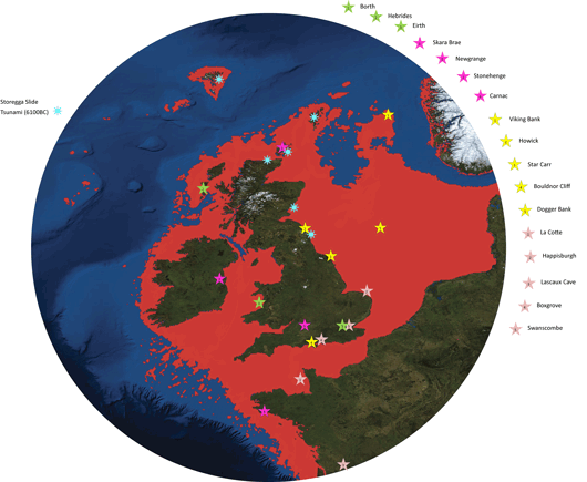
A map of the UK with Doggerland, now sunken, marked as red. In the Norwegian Sea, the Storegga Slide caused a megatsunami approximately 7,000 years ago and caused the final end of Doggerland which had been slowly submerging since the end of the Ice Age.. The hypothesis is a major tsunami was generated by an underwater slide off the west coast of Norway was first proposed by J. I. Svendsen in 1985 and further elaborated in a large number of studies a comparatively large number of deposits on the coasts of Norway and eastern Scotland can now be safely attributed to the Second Storegga Slide tsunami. The generation of the megatsunami apparently involved some 2400–3200km of material that spread across the North Atlantic sea floor, altogether covering an area of around 95000 km that is about the size of Scotland. It has been suggested the cause of the Storegga slide was a strong earthquake in the North Atlantic, but further investigations are necessary to substantiate this hypothesis. Due to the large slide/slump volume and extensive reworking, the direct dating of the slide sediments is no easy matter.
A hidden underwater world with a dramatic past is being revealed by University of St Andrews scientists this week (3-8 July 2012) at a major public science festival. The story behind Doggerland, a land that was slowly submerged by water between 18000 BC and 5500 BC, will be unveiled at the annual Royal Society Summer Science Exhibition opening Tuesday 3 July 2012. Organised by Dr Richard Bates of the Department of Earth Sciences at St Andrews, the Drowned Landscapes exhibit reveals the human story behind Doggerland, a now submerged area of the North Sea that was once larger than many modern European countries. Dr Bates, a geophysicist, commented, “Doggerland was the real heartland of Europe until sea levels rose to give us the UK coastline of today. We have speculated for years on the lost land’s existence from bones dredged by fishermen all over the North Sea, but it’s only since working with oil companies in the last few years that we have been able to re-create what this lost land looked like.
“When the data was first being processed, I thought it unlikely to give us any useful information, however as more area was covered it revealed a vast and complex landscape. We have now been able to model its flora and fauna, build up a picture of the ancient people that lived there and begin to understand some of the dramatic events that subsequently changed the land, including the sea rising and a devastating tsunami.”
The research project is a collaboration between St Andrews and the Universities of Aberdeen, Birmingham, Dundee and Wales Trinity St David. Rediscovering the land through pioneering scientific research, the research reveals a story of a dramatic past that featured massive climate change. The public exhibit brings back to life the Mesolithic populations of Doggerland through artefacts discovered deep within the sea bed. The research suggests that the populations of these drowned lands could have been tens of thousands, living in an area that stretched from Northern Scotland across to Denmark and down the English Channel as far as the Channel Islands. The research, a result of a painstaking 15 years of fieldwork around the murky waters of the UK, is one of the highlights of the London event. The interactive display examines the lost landscape of Doggerland and includes artefacts from various times represented by the exhibit – from pieces of flint used by humans as tools to the animals that also inhabited these lands. Using a combination of geophysical modelling of data obtained from oil and gas companies and direct evidence from material recovered from the seafloor, the research team was able to build up a reconstruction of the lost land. The findings suggest a picture of a land with hills and valleys, large swamps and lakes with major rivers dissecting a convoluted coastline. As the sea rose the hills would have become an isolated archipelago of low islands. By examining the fossil record (such as pollen grains, microfauna and macrofauna) the researchers can tell what kind of vegetation grew in Doggerland and what animals roamed there. Using this information, they were able to build up a model of the ‘carrying capacity’ of the land and work out roughly how many humans could have lived there.
The research team is currently investigating more evidence of human behaviour, including possible human burial sites, intriguing standing stones and a mass mammoth grave. Dr Bates continued, “We haven’t found an ‘x marks the spot’ or ‘Joe created this’, but we have found many artefacts and submerged features that are very difficult to explain by natural causes, such as mounds surrounded by ditches and fossilised tree stumps on the seafloor. “There is actually very little evidence left because much of it has eroded underwater; it’s like trying to find just part of a needle within a haystack. What we have found though is a remarkable amount of evidence and we are now able to pinpoint the best places to find preserved signs of life.” The only lands on Earth that have not been extensively explored are those that have been lost to the oceans. After the end of the last Ice Age extensive landscapes that had once been home to thousands of people were inundated by the sea. Although scientists predicted their existence for many years, exploration has only recently become a reality. A virtual visualisation of an Agent Based model of life in the Mesolithic on the Doggerbank.
This exhibit explores those drowned landscapes around the UK and shows how they are being rediscovered through pioneering scientific research. It reveals their human story through the artefacts left by the people - a story of a dramatic past that featured lost lands, devastating tsunamis and massive climate change. These were the challenges that our ancestors met and that we face once more today. How it works Current climate change and associated sea level rise are at the forefront of social and scientific discussion, but research shows that dramatic changes in the environment have occurred numerous times in the past.
edit on 4-7-2012 by WiindWalker because: (no reason given)
edit on 4-7-2012 by WiindWalker because: (no reason
given)
edit on 4-7-2012 by WiindWalker because: (no reason given)
edit on 4-7-2012 by WiindWalker because: (no reason
given)
ambiguous title of yesterdays thread makes it harder to find, but here's all that already and an existing thread
www.abovetopsecret.com...
www.abovetopsecret.com...
One of the most significant landscapes lost to sea level rise is the European world of Doggerland. Occupying much of the North Sea basin, this inundated landscape, bigger than many modern European countries, was slowly submerged between 18,000 BC and 5,500 BC. Archaeologists now consider Doggerland to have been the heartland of human occupation within Northern Europe at that time, but understanding it depends on being able to locate and visualise the landscape. Perhaps many people don't realise but until about 6000 years ago, 6-7000 years ago, the current area of the southern North Sea was actually dry land. It was inhabited by hunter gatherers who roamed across pretty much the whole of the area between Yorkshire and Denmark, says Gaffney However, of course, global warming, the end of the Ice Age, rising sea levels, meant that this landscape was actually swallowed up by the sea over time and it was pretty much lost to knowledge. About 6/7 years ago, we started a project using oil data - data collected by the oil industry from seismic actually - to start mapping this lost landscape and the results have actually been wonderful. Currently we've mapped rivers, hills, lakes, marshes, over an area of about 23000 square kilometres. That's an entirely new prehistoric country in fact and we're now starting to try and use that information to model where hunter gatherers may have lived with the idea that we'll eventually go back to sea and use modern coring techniques to see if we can find traces of settlement, says Gaffney. That's a first and we're very excited that we've been able to carry out that sort of innovative exploration at Birmingham. But we are recognised as innovators within digital archaeology and remote sensing and this probably has been one of the most important and largest projects of its kind in this country or indeed the world.
The past is sometimes said to be a foreign country, but less than 12,000 years ago Europe was a very different and almost unrecognisable place where Britain did not exist as a separate land. Over thousands of years the climate changed, sea levels rose and the entire coast of Europe morphed into the familiar shape we know today. Britain, formerly a range of hills on the edge of a great plain, gradually separated from continental Europe. This lost country, known as Doggerland, was not empty but inhabited by communities of hunter-gatherers who roamed, hunting and gathering resources, just as they did in many other areas of northern Europe. Using the latest technologies we can now describe this amazing landscape in detail for the first time and reveal the valleys, hills, rivers and plains which lie beneath the North Sea and which were home to unique cultures, tribes and, perhaps, thousands of people. This lecture by Vince Gaffney presents the results of a remarkable programme of archaeological research by the University of Birmingham to rediscover Doggerland, the enigmatic country which once linked the Yorkshire coast with a stretch of Continental Europe from Denmark to Normandy but which now lies beneath the North Sea. to rediscover Doggerland, the enigmatic country which once linked the Yorkshire coast with a stretch of Continental Europe from Denmark to Normandy but which now lies beneath the North Sea.
edit on 4-7-2012 by WiindWalker because: (no reason given)
1) It's not a continent.
2) It's not the Cradle of Europe.
3) It's not news, they've been aware of Doggerland for ages - this is just the first time human remains have been found (human artifacts, flint for instance, has been found before - but not remains).
2) It's not the Cradle of Europe.
3) It's not news, they've been aware of Doggerland for ages - this is just the first time human remains have been found (human artifacts, flint for instance, has been found before - but not remains).
edit on 4/7/2012 by Kolya because: (no reason given)
Originally posted by Kolya
1) It's not a continent.
2) It's not the Cradle of Europe.
3) It's not news, they've been aware of Doggerland for ages - this is just the first time human remains have been found (human artifacts, flint for instance, has been found before - but not remains).
edit on 4/7/2012 by Kolya because: (no reason given)
1.I apologized for re-threading
2. I could care less
3. I am here to inform
Originally posted by WiindWalker
Originally posted by Kolya
1) It's not a continent.
2) It's not the Cradle of Europe.
3) It's not news, they've been aware of Doggerland for ages - this is just the first time human remains have been found (human artifacts, flint for instance, has been found before - but not remains).
edit on 4/7/2012 by Kolya because: (no reason given)
1.I apologized for re-threading
2. I could care less
3. I am here to inform
Idd, Nice find mate was a nice read! never heard about Doggerland before.
new topics
-
Maestro Benedetto
Literature: 1 minutes ago -
Is AI Better Than the Hollywood Elite?
Movies: 10 minutes ago -
Las Vegas UFO Spotting Teen Traumatized by Demon Creature in Backyard
Aliens and UFOs: 3 hours ago -
2024 Pigeon Forge Rod Run - On the Strip (Video made for you)
Automotive Discussion: 4 hours ago -
Gaza Terrorists Attack US Humanitarian Pier During Construction
Middle East Issues: 4 hours ago -
The functionality of boldening and italics is clunky and no post char limit warning?
ATS Freshman's Forum: 5 hours ago -
Meadows, Giuliani Among 11 Indicted in Arizona in Latest 2020 Election Subversion Case
Mainstream News: 6 hours ago -
Massachusetts Drag Queen Leads Young Kids in Free Palestine Chant
Social Issues and Civil Unrest: 6 hours ago -
Weinstein's conviction overturned
Mainstream News: 8 hours ago -
Supreme Court Oral Arguments 4.25.2024 - Are PRESIDENTS IMMUNE From Later Being Prosecuted.
Above Politics: 9 hours ago
top topics
-
Krystalnacht on today's most elite Universities?
Social Issues and Civil Unrest: 9 hours ago, 9 flags -
Supreme Court Oral Arguments 4.25.2024 - Are PRESIDENTS IMMUNE From Later Being Prosecuted.
Above Politics: 9 hours ago, 8 flags -
Weinstein's conviction overturned
Mainstream News: 8 hours ago, 7 flags -
University of Texas Instantly Shuts Down Anti Israel Protests
Education and Media: 12 hours ago, 6 flags -
Massachusetts Drag Queen Leads Young Kids in Free Palestine Chant
Social Issues and Civil Unrest: 6 hours ago, 6 flags -
Gaza Terrorists Attack US Humanitarian Pier During Construction
Middle East Issues: 4 hours ago, 6 flags -
Meadows, Giuliani Among 11 Indicted in Arizona in Latest 2020 Election Subversion Case
Mainstream News: 6 hours ago, 5 flags -
Las Vegas UFO Spotting Teen Traumatized by Demon Creature in Backyard
Aliens and UFOs: 3 hours ago, 3 flags -
2024 Pigeon Forge Rod Run - On the Strip (Video made for you)
Automotive Discussion: 4 hours ago, 2 flags -
Any one suspicious of fever promotions events, major investor Goldman Sachs card only.
The Gray Area: 14 hours ago, 2 flags
active topics
-
University of Texas Instantly Shuts Down Anti Israel Protests
Education and Media • 209 • : cherokeetroy -
Maestro Benedetto
Literature • 0 • : BrotherKinsMan -
Massachusetts Drag Queen Leads Young Kids in Free Palestine Chant
Social Issues and Civil Unrest • 11 • : marg6043 -
Electrical tricks for saving money
Education and Media • 7 • : chr0naut -
Definitive 9.11 Pentagon EVIDENCE.
9/11 Conspiracies • 424 • : Zanti Misfit -
Is AI Better Than the Hollywood Elite?
Movies • 0 • : 5thHead -
Las Vegas UFO Spotting Teen Traumatized by Demon Creature in Backyard
Aliens and UFOs • 8 • : Macenroe82 -
British TV Presenter Refuses To Use Guest's Preferred Pronouns
Education and Media • 163 • : rigel4 -
SHORT STORY WRITERS CONTEST -- April 2024 -- TIME -- TIME2024
Short Stories • 23 • : DontTreadOnMe -
Meadows, Giuliani Among 11 Indicted in Arizona in Latest 2020 Election Subversion Case
Mainstream News • 13 • : xuenchen
3