It looks like you're using an Ad Blocker.
Please white-list or disable AboveTopSecret.com in your ad-blocking tool.
Thank you.
Some features of ATS will be disabled while you continue to use an ad-blocker.

USAF Marker at Abandoned Airfield Near TTR/Area 51
page: 12
share:
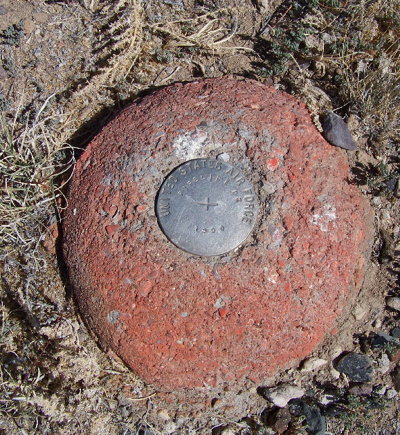
On my recent trip (last week of May, first week of June) to the range, I found this marker while exploring "Tonopah #2 Auxiliary Army Airfield", near
Cactus Gate, which is near Cedar Gate.
As per my Garmin GPS, it is at:
37° 44.111'N, 116° 9.169'W
Anyone seen one of these before? Peter Merlin, gariac? I have seen pics of elevation markers, but not one marked:
United States Air Force
Pipeline DZ (drop zone?)
1990
EDITED TO ADD:
It seems I follow in gariac's footsteps - here is a detailed explanation of what and where these marker(s) are:
www.lazygranch.com...
edit on 1-7-2012 by FosterVS because: (no reason given)
reply to post by FosterVS
Haha, we shoulda known and kinda had a feeling. Go figure.
Haha, we shoulda known and kinda had a feeling. Go figure.
edit on 7/1/2012 by DesertWatchdog because: (no reason given)
reply to post by FosterVS
www.abovetopsecret.com...
skinwalkerranch.org...
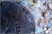
Photo from skinwalker original from the above link
This looks very similar to the one you posted..this one is located on Skinwalker ranch in Utah and it's an old Observing Monument.
www.abovetopsecret.com...
skinwalkerranch.org...
Photo from skinwalker original from the above link
This looks very similar to the one you posted..this one is located on Skinwalker ranch in Utah and it's an old Observing Monument.
reply to post by DesertWatchdog
They had signs to the drop zones there for the longest time. Then some fool (me) decided it would be just barely interesting to document the drop zones and the signs. Well on my next visit to the range, the signs were removed. Who knew they actually cared about the locations. The cattle depended on those signs for scratching!
You would think that if anyone had to find the drop zones, the USAF would just give them GPS coordinates and a map. Well I was out there with a group and somebody wanted to see the drop zones. (Why, I forget). We headed out in a small convoy (3 cars) with me at the lead. I had all the turns marked on my GPS. What I didn't count on was the USAF conducting GPS jamming. The signal just disappeared from my GPS. No satellites seen. What I discovered was the USAF has put a large rock by the turn to the Pipeline DZ. The rock is painted fire engine red. [OK, now I guess they will remove that rock.]
The drop zones are used sometimes during MAFEX.
www.abovetopsecret.com...
Usually they just drop barrels full of water. The barrels are heavy enough to make work for the loadmaster, but easy enough to recover on the ground by dumping the water and hauling away the empty barrels. Other times the drop zones are used for HALO jumps.
If you are in the area and there is a drop scheduled, the people in charge will move you to a safe location, but not run you out of the area. They have a rough idea about the accuracy of the drop, and just put you out of danger. I saw a heavy crate dropped once (no idea what was inside) and one of the chutes failed to open. It didn't look good.;-)
The only other defense related marker I have seen around the range is the one on Mt. Diablo. Not Mt. Diablo California (a serious mountain), but the molehill known as Mt. Diablo by the TTR. For reasons I can't fathom, that insignificant hill is the marker for much of south Nevada.
www.satelliteviews.net...
In the satellite image, that is the TTR mancamp at the bottom.
I don't think I have a photo online of the Mt. Diablo marker, but it is stamped Defense Mapping Agency or DMA. There is a small concrete pad in the area. It might be related to JEFX, since I saw a temporary microwave relay site set up on the pad.
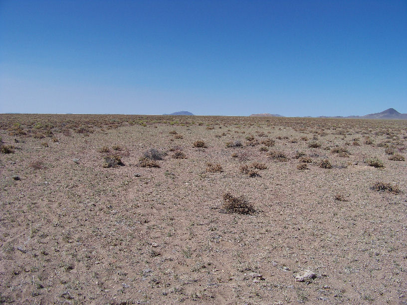
FYI to anyone who has the urge to visit this "airfield" or the other ones i.e. Tonopah AAA #1 on public land. This is what you can expect to see,
looking SW from that marker. Despite what GE shows, you can barely tell you are on an "airstrip", other than more patchy white ground than the
surrounding desert.
reply to post by FosterVS
I suppose it would be nice if a plane that landed on a emergency runway would be in condition to take off again. I don't think that would be true for the emergency runways around the Cedar Pipeline ranch.
Possibly the F-15 that crashed near the Cedar Pipeline Ranch was headed to one of the emergency runways.
www.lazygranch.com...
new topics
-
VP's Secret Service agent brawls with other agents at Andrews
Mainstream News: 6 minutes ago -
Sunak spinning the sickness figures
Other Current Events: 47 minutes ago -
Nearly 70% Of Americans Want Talks To End War In Ukraine
Political Issues: 58 minutes ago -
Late Night with the Devil - a really good unusual modern horror film.
Movies: 2 hours ago -
Cats Used as Live Bait to Train Ferocious Pitbulls in Illegal NYC Dogfighting
Social Issues and Civil Unrest: 4 hours ago -
The Good News According to Jesus - Episode 1
Religion, Faith, And Theology: 6 hours ago -
HORRIBLE !! Russian Soldier Drinking Own Urine To Survive In Battle
World War Three: 8 hours ago -
Bobiverse
Fantasy & Science Fiction: 11 hours ago -
Florida man's trip overseas ends in shock over $143,000 T-Mobile phone bill
Social Issues and Civil Unrest: 11 hours ago
top topics
-
Florida man's trip overseas ends in shock over $143,000 T-Mobile phone bill
Social Issues and Civil Unrest: 11 hours ago, 8 flags -
SETI chief says US has no evidence for alien technology. 'And we never have'
Aliens and UFOs: 15 hours ago, 7 flags -
Cats Used as Live Bait to Train Ferocious Pitbulls in Illegal NYC Dogfighting
Social Issues and Civil Unrest: 4 hours ago, 7 flags -
This is our Story
General Entertainment: 17 hours ago, 4 flags -
Former Labour minister Frank Field dies aged 81
People: 13 hours ago, 4 flags -
Bobiverse
Fantasy & Science Fiction: 11 hours ago, 3 flags -
HORRIBLE !! Russian Soldier Drinking Own Urine To Survive In Battle
World War Three: 8 hours ago, 2 flags -
Late Night with the Devil - a really good unusual modern horror film.
Movies: 2 hours ago, 2 flags -
Nearly 70% Of Americans Want Talks To End War In Ukraine
Political Issues: 58 minutes ago, 1 flags -
VP's Secret Service agent brawls with other agents at Andrews
Mainstream News: 6 minutes ago, 1 flags
2