It looks like you're using an Ad Blocker.
Please white-list or disable AboveTopSecret.com in your ad-blocking tool.
Thank you.
Some features of ATS will be disabled while you continue to use an ad-blocker.

Colorado Springs Apocolypse?! Waldo Canyon Wildfire 32,000 Evacuated, Many Houses/Buildings Burned!
page: 21share:
reply to post by autopat51
From KKTV web site...Updated
4:30 p.m. June 27
Important Note
Please don't call 911 about the smoke. Agencies are getting flooded with calls and are already responding to the fire.
Estimated Containment Date
Monday July 16th, 2012 approx. 12:00 AM
Estimated Size
15,517 acres
Number of personnel
764
Containment
5%
Fuels Involved
Brush, hardwood slash, Mountain shrub, oak, grass, Pinon pine, juniper, Ponderosa pine, Douglas fir, spruce, Limber pine, White pine
Fire Behavior
Extreme fire behavior with extreme rates of spread and active surface fire. Increase in fire perimeter along the north and east flanks. Active crown fire with sustained runs. Fire continues to back down toward Highway 24.
Significant Events
Fire activity increased along the entire perimeter due to Red Flag Conditions, wind shifts and Haines Index of 6 (very high). Fire has reached the south side of Rampart Recreation Area and reservior with a burnout being conducted to protect infrastructure. Indirect line location opportunities are being assessed north of Lucky 4 Road. Incident has expanded to include Division D and X based on northwest growth of fire perimeter. An evacuation has been issued by the City of Colorado Springs for Mt Springs, Peregrine and Westwood. At approximately 4 pm the fire progressed west to east in Division Y crossing Queens Canyon and established itself on the east aspect of the Front Range. The evacuation order for Crystal Park subdivision has been lifted and residents allowed to return.
Planned Actions
Improve pipeline easement contingency line south of Woodland Park going east from Hwy 24 and tying into Rampart Recreation Area. Continue to hold Rampart Range Road to prevent fire from moving northeast and east. Continue point protection in Cedar Heights and continue structure protection along the west side of Colorado Springs.
Growth Potential
Extreme
Terrain Difficulty
Extreme
reply to post by ManicDepresive1
thank you for the report
isnt it wonderful that they can pinpoint containment
3 weeks away..and to the hour!!! wow
thank you for the report
isnt it wonderful that they can pinpoint containment
3 weeks away..and to the hour!!! wow
edit on 27-6-2012 by autopat51 because: (no reason given)
From Wikipedia: "Haines Index is a weather index developed by meteorologist Donald Haines in 1988 that measures the potential for rapid forest fire
growth. The index is derived from the stability (temperature difference between different levels of the atmosphere) and moisture content (dew point
depression) of the lower atmosphere. These data may be acquired with a radiosonde. The index is calculated over three ranges of atmospheric pressure:
low elevation (950-850 millibars (mb)), mid elevation (850-700 mb), and high elevation (700-500 mb).[1]
A Haines index of 6 means a high potential for large fire growth, 5 medium potential, 4 low potential, and anything less than 4 equates to very low potential."
A Haines index of 6 means a high potential for large fire growth, 5 medium potential, 4 low potential, and anything less than 4 equates to very low potential."
reply to post by ManicDepresive1
Thanks for posting the report as concerning as
it is. I am sending postive energy to all of those
in need at this time. Stay safe and check in with
us when you can.
Thanks for posting the report as concerning as
it is. I am sending postive energy to all of those
in need at this time. Stay safe and check in with
us when you can.
inciweb.org....
"Waldo Canyon Fire Update
Incident: Waldo Canyon Fire Wildfire
Released: 6 hrs. ago
Fire Facts:
Date started: June 23, 2012
Number of Personnel: 764
Location: West of Colorado Springs
Crews: 19
Size: 15,517 acres
Engines: 50
Percent Contained: 5%
Water Tenders: 1
Estimated Containment: 7/16/12
Helicopters: 2 Type 1, 3 Type 2 and 2Type 3
Cause: Under investigation
Injuries to Date: 0
Structures threatened: 20,085 residences and 160 commercial structures
Evacuees: Approx. 32, 000
Cost to Date: $1, 950, 000
Structures lost Yet to be determined
Today's Events:
Overnight the fire continued to back down towards Hwy 24 as firefighters continued to hold and maintain the perimeter east of the Hwy. Structure protection continued along the Hwy, north of the current fire line. Firefighters continued to hold improve the line on the northwest perimeter, which had been created using burnout operations earlier in the day, along Rampart Range Road. On the northeast flank, fire continued to back down to West Monument Creek. A spot fire north of Rampart Reservoir was very active overnight. Structure protection continued in around the Eagle Lake Camp and in Cedar Heights.
Today firefighters will once again face Red Flag conditions with thunderstorms expected in the afternoon. They will continue to secure structures in Wellington Canyon, and secure the community of Cascade. Firefighters will initiate structure protection further to the north along Hwy 24 and scout for contingency lines. Control operations will continue on the north and east along West Monument Creek. Firefighters are working with the City of Colorado Springs Fire Department on the west to focus primarily on structure protection. Structure protection will continue around Eagle Camp and Cedar Heights.
Evacuations and Closures
Cascade, Cedar Heights Subdivision, Chipita Park, Crystal Park, Green Mountain Falls,
Currently on mandatory evacuation.
City of Colorado Springs
All areas north of Garden of the Gods Rd. between I-25 to the east all the way to the western City limits and north to the Air Force Academy.
Air Force Academy
Evacuated areas included Academy Dr. to their southern and western boundaries.
US 24
Closed in both directions between Cave of the Winds and Crystola.
I-25
I-25 southbound at Interquest Parkway
Woodland Park
On pre-evacuation notice as a precaution (be prepared and follow local news).
Pike National Forest
Order 12-08 closes the Pike National Forest in the area of the Waldo Canyon Fire as shown on map of order.
Red Cross Shelters
Lewis Palmer High School (1300 Higby, Monument, CO)
Cheyenne Mountain High School (1200 Cresta Road, Colorado Springs, CO)
Southeast YMCA (2190 Jet Wing Drive, Colorado Springs, CO)
Summit Elementary School, Divide, CO
Evacuees should register on www.redcross.org/safeandwell. Family and friends can check status there and also by phone at (719) 785-2724.
For information on sheltering animals, please refer to this document:
www.springsgov.com...
Donations/Volunteers
Pikes Peak Red Cross www.pparc.org... Money only; will also register volunteers
Care and Share 2605 Preamble Point Food and non-perishables, M-F, 7 am - 6 pm
Goodwill www.discovermygoodwill.org... Distributing donations to evacuees as needed
Please DO NOT bring donations directly to shelters or the incident command post. They cannot handle donations or distribution of them.
Non-Emergency Assistance and Service Referrals
Pikes Peak United Way (719) 955-0742"
Originally posted by Wookiep
Overhead view of Flying W Ranch posted by Flying W Ranch Inc on Facebook..
What a shame. :/
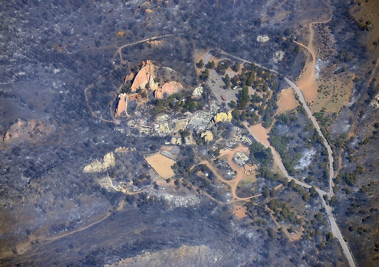
Wow that is my first time seeing an aerial of it. I grew up here and my folks who live near Gardon of the Gods, just north of Coronado High School, were evacuated early yesterday. Their house hasn't been hit but they are not being allowed anywhere near.
Originally posted by Agarta
Originally posted by Foxe
reply to post by Agarta
"then you come to a solid vault type door 25 feet thick
This is all you need to call BS.
The reports posted from KKTV and Inciweb are still pretty muh accurate, except the acres has reached 18,500 as the live news reports said on T.V. a
few hours ago.
Otherwise, no news is good news. Looks like tonight may bring some rest, finally.
Otherwise, no news is good news. Looks like tonight may bring some rest, finally.
Wildfires can be a horrifying experience, even for those not directly involved. Black saturday was one of the saddest and most devistating events in
Ausralias history. I feel for the people of Colorado Springs, and all americans watching this unfold.
We had a fizzer of a fire season down here last year, nothing much happened at all. This season (which starts officially in about four months), will be different. Things have dried out a bit and the re-growth from the last fires has come back with a vengence.
To make matteres worse, the DSE/Parks Vic/CFA here in Victoria only got about 40% of our fuel reducion burns done. Even worse than that, our beloved Senetor Ted Baillieu, started sacking Firefighters and contractors (nearly 450 jobs all up). He also plans to drop the intake number of seasonal fire workers further this coming season, yet he wants twice the ammount of fuel reduction done.
How half the number of workers are going to accomplish double the burns and fight wildfires at the same time this year is beyond me...
If TSHTF in Victoria in 2012-2013, we'll be seeing more images like the ones in the OP from down here...
edit on 6/28/2012 by Ironclad because: (no reason given)
Originally posted by Wookiep
The reports posted from KKTV and Inciweb are still pretty muh accurate, except the acres has reached 18,500 as the live news reports said on T.V. a few hours ago.
Otherwise, no news is good news. Looks like tonight may bring some rest, finally.
Accurate acreage will be available at the 08:00MST briefing. This is after the 23:00MST over flight of the fire with infrared camera data has been processed by the GIS folks.
Originally posted by Wookiep
Overhead view of Flying W Ranch posted by Flying W Ranch Inc on Facebook..
What a shame. :/
I can't believe its gone....
I hope Glenn Eryie isn't next.
I can't explain how horrific it is to see a beutiful city burn....my home.
Updated info from Inciweb:
Total Personnel
1,200
Size
18,500 acres
Percent Contained
5%
Estimated Containment Date
Monday July 16th, 2012 approx. 12:00 AM
Fuels Involved
Brush, hardwood slash, Mountain shrub, oak, grass, Pinon pine, juniper, Ponderosa pine, Douglas fir, spruce, Limber pine, White pine
Fire Behavior
Extreme fire behavior with extreme rates of spread and active surface fire. Increase in fire perimeter along the north and east flanks. Active crown fire with sustained runs. Fire continues to back down toward Highway 24.
Significant Events
Fire activity increased along the entire perimeter due to Red Flag Conditions, wind shifts and Haines Index of 6 (very high). Fire has reached the south side of Rampart Recreation Area and reservior with a burnout being conducted to protect infrastructure. Indirect line location opportunities are being assessed north of Lucky 4 Road. Incident has expanded to include Division D and X based on northwest growth of fire perimeter. An evacuation has been issued by the City of Colorado Springs for Mt Springs, Peregrine and Westwood. At approximately 4 pm the fire progressed west to east in Division Y crossing Queens Canyon and established itself on the east aspect of the Front Range. The evacuation order for Crystal Park subdivision has been lifted and residents allowed to return.
Outlook
Planned Actions
Improve pipelone easement contingency line south of Woodland Park going east from Hwy 24 and tying into Rampart Recreation Area. Continue to hold Rampart Ridge Road to prevent fire from moving northeast and east. Continue point protection in Cedar Heights and continue structure protection along the west side of Colorado Springs.
Growth Potential
Extreme
Terrain Difficulty
Extreme
Current Weather
Wind Conditions
12 mph SW
Temperature
93 degrees
Humidity
8%
www.inciweb.org...
edit on 28-6-2012 by Wookiep because: (no reason given)
reply to post by Wookiep
Hey Wookiep,
just jumping in and haven't read the last few pages...my brother in NY told me he saw a press conference yesterday where Hinkenlooper said he had information that indicated the fires were manmade...anyone else hear this? Stay well.
CJ
Hey Wookiep,
just jumping in and haven't read the last few pages...my brother in NY told me he saw a press conference yesterday where Hinkenlooper said he had information that indicated the fires were manmade...anyone else hear this? Stay well.
CJ
I talked to my friend and she is 30 miles from the fire with the
wind in their direction. I was wondering if the fire would go that
far, I certainly hope not. She said the air was thick with smoke.
Stay safe Colorado friends - I continue to read all posts
and updates on this thread.
wind in their direction. I was wondering if the fire would go that
far, I certainly hope not. She said the air was thick with smoke.
Stay safe Colorado friends - I continue to read all posts
and updates on this thread.
Morning. Latest is....... 300+ homes burned, still 32,000 evacuated,Thursday will be a similar day compared to Wednesday, but the fire danger will be
a bit lower. For the first time since the Waldo Canon fire started there is not a red flag warning in effect. The overall wind pattern today will be
lighter, but gusty outflow winds are possible later
Latest Update
Latest Update
edit on 28-6-2012 by ManicDepresive1
because: added link
reply to post by ColoradoJens
There was a story on Colrado Springs cragslist wher a guy say he saw the person and has pic for the athourities , he says he has left his info on tip line, but so far no one has contacted him. Is it true?? Who knows.
Link
There was a story on Colrado Springs cragslist wher a guy say he saw the person and has pic for the athourities , he says he has left his info on tip line, but so far no one has contacted him. Is it true?? Who knows.
Link
Just re-posting the link to Google maps for this fire. It was just updated 2 hours ago.
Google Maps - Waldo Canyon fire
Google Maps - Waldo Canyon fire
My father told me that he heard a report that some folks upon the mountain, around Rampart Range Rd. Encountered a man who was leaving the scene
shortly after the fire started. He said that they confronted the man and asked him to help put the fires out and the man refused to help and left the
scene. He did provide a brief description of the man, but since I don't know what his source for this man or remember the description accurately I am
not going to post the brief description, to protect the innocent. But he did tell me that there was a person of interest and currently they are
looking for this person.
reply to post by ManicDepresive1
Thanks for that update ManicDepresive1. I've been out of the house today and have been wondering how everything was in the area.
Just came across a link that has before & after photos of some of the neighborhoods that have been hit. So incredibly sad to see those homes completely leveled.
www.denverpost.com
My thoughts continue to be with you all!
OiO
Originally posted by ColoradoJens
reply to post by Wookiep
Hey Wookiep,
just jumping in and haven't read the last few pages...my brother in NY told me he saw a press conference yesterday where Hinkenlooper said he had information that indicated the fires were manmade...anyone else hear this? Stay well.
CJ
There still has been no info (officially released to my knowledge) about the cause of the fire, but many are saying what you are. The investigation is still going on. Yesterday, video came out from someone who was there when it started, so they are aware of the exact location.
EDIT: Oh and they did say last night that lightning has been ruled out.
edit on 28-6-2012 by Wookiep because: (no reason given)
new topics
-
Las Vegas UFO Spotting Teen Traumatized by Demon Creature in Backyard
Aliens and UFOs: 1 hours ago -
2024 Pigeon Forge Rod Run - On the Strip (Video made for you)
Automotive Discussion: 2 hours ago -
Gaza Terrorists Attack US Humanitarian Pier During Construction
Middle East Issues: 3 hours ago -
The functionality of boldening and italics is clunky and no post char limit warning?
ATS Freshman's Forum: 4 hours ago -
Meadows, Giuliani Among 11 Indicted in Arizona in Latest 2020 Election Subversion Case
Mainstream News: 4 hours ago -
Massachusetts Drag Queen Leads Young Kids in Free Palestine Chant
Social Issues and Civil Unrest: 4 hours ago -
Weinstein's conviction overturned
Mainstream News: 6 hours ago -
Supreme Court Oral Arguments 4.25.2024 - Are PRESIDENTS IMMUNE From Later Being Prosecuted.
Above Politics: 7 hours ago -
Krystalnacht on today's most elite Universities?
Social Issues and Civil Unrest: 7 hours ago -
Chris Christie Wishes Death Upon Trump and Ramaswamy
Politicians & People: 8 hours ago
top topics
-
Krystalnacht on today's most elite Universities?
Social Issues and Civil Unrest: 7 hours ago, 9 flags -
Weinstein's conviction overturned
Mainstream News: 6 hours ago, 6 flags -
Supreme Court Oral Arguments 4.25.2024 - Are PRESIDENTS IMMUNE From Later Being Prosecuted.
Above Politics: 7 hours ago, 6 flags -
University of Texas Instantly Shuts Down Anti Israel Protests
Education and Media: 10 hours ago, 6 flags -
Massachusetts Drag Queen Leads Young Kids in Free Palestine Chant
Social Issues and Civil Unrest: 4 hours ago, 4 flags -
Meadows, Giuliani Among 11 Indicted in Arizona in Latest 2020 Election Subversion Case
Mainstream News: 4 hours ago, 4 flags -
Chris Christie Wishes Death Upon Trump and Ramaswamy
Politicians & People: 8 hours ago, 2 flags -
Any one suspicious of fever promotions events, major investor Goldman Sachs card only.
The Gray Area: 12 hours ago, 2 flags -
Gaza Terrorists Attack US Humanitarian Pier During Construction
Middle East Issues: 3 hours ago, 2 flags -
2024 Pigeon Forge Rod Run - On the Strip (Video made for you)
Automotive Discussion: 2 hours ago, 1 flags
active topics
-
-@TH3WH17ERABB17- -Q- ---TIME TO SHOW THE WORLD--- -Part- --44--
Dissecting Disinformation • 680 • : 777Vader -
Supreme Court Oral Arguments 4.25.2024 - Are PRESIDENTS IMMUNE From Later Being Prosecuted.
Above Politics • 73 • : xuenchen -
Is there a hole at the North Pole?
ATS Skunk Works • 40 • : Oldcarpy2 -
Fossils in Greece Suggest Human Ancestors Evolved in Europe, Not Africa
Origins and Creationism • 89 • : whereislogic -
Meadows, Giuliani Among 11 Indicted in Arizona in Latest 2020 Election Subversion Case
Mainstream News • 7 • : chr0naut -
University of Texas Instantly Shuts Down Anti Israel Protests
Education and Media • 197 • : NorthOS -
Candidate TRUMP Now Has Crazy Judge JUAN MERCHAN After Him - The Stormy Daniels Hush-Money Case.
Political Conspiracies • 790 • : Oldcarpy2 -
Weinstein's conviction overturned
Mainstream News • 20 • : Xtrozero -
Cats Used as Live Bait to Train Ferocious Pitbulls in Illegal NYC Dogfighting
Social Issues and Civil Unrest • 22 • : NoviceStoic4 -
Sunak spinning the sickness figures
Other Current Events • 22 • : angelchemuel