It looks like you're using an Ad Blocker.
Please white-list or disable AboveTopSecret.com in your ad-blocking tool.
Thank you.
Some features of ATS will be disabled while you continue to use an ad-blocker.

Earthquakes since 1898 (beautiful map)
page: 19
share:
IDV Solutions
The lines are right where one would expect them, but the results a beautiful.
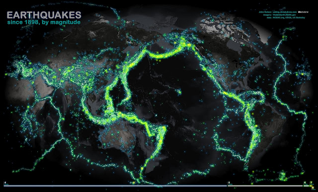
Here, data from NCEDC.org and the USGS and UC Berkeley have been sliced out into veneers based on magnitude, then glued onto and image that began it's life at NASA's Visual Earth and wrung into the Times projection (centered at the interesting bits). The result looks an awful lot like a fleet of Nickelodeon tankers spilled the world's supply of floam.
The lines are right where one would expect them, but the results a beautiful.
Very nice man!!!
It shows you how the countries were connected at one time... but it's getting worse by i talk.
It shows you how the countries were connected at one time... but it's getting worse by i talk.
reply to post by AnonymousCitizen
The only issue I have with it is that the article does not give a clear minimum of earthquake size to be included on the map. It is clear to see the New Madrid area is empty, as well as the fault line along the Nebraska/Iowa/Missouri boarder, as well as Oklahoma. I would venture to say this is far from complete. I am not dissing the work put into it and it is visually nice and does show the Ring of Fire very well.
The only issue I have with it is that the article does not give a clear minimum of earthquake size to be included on the map. It is clear to see the New Madrid area is empty, as well as the fault line along the Nebraska/Iowa/Missouri boarder, as well as Oklahoma. I would venture to say this is far from complete. I am not dissing the work put into it and it is visually nice and does show the Ring of Fire very well.
its a shame they didn't spilt the map in 2, or have they?
1898 to 1956 and 1956 to 2012, would be a good visual guide to any changes.
1898 to 1956 and 1956 to 2012, would be a good visual guide to any changes.
new topics
-
We need less laws in the UK not more
General Chit Chat: 2 hours ago -
The Baloney aka BS Detection Kit
Social Issues and Civil Unrest: 7 hours ago -
Suspected Iranian agent working for Pentagon while U.S. coordinated defense of Israel
US Political Madness: 7 hours ago -
How does my computer know
Education and Media: 10 hours ago
top topics
-
Suspected Iranian agent working for Pentagon while U.S. coordinated defense of Israel
US Political Madness: 7 hours ago, 13 flags -
USO 10 miles west of caladesi island, Clearwater beach Florida
Aliens and UFOs: 14 hours ago, 9 flags -
The Baloney aka BS Detection Kit
Social Issues and Civil Unrest: 7 hours ago, 6 flags -
How does my computer know
Education and Media: 10 hours ago, 3 flags -
We need less laws in the UK not more
General Chit Chat: 2 hours ago, 2 flags
9